
The question “Where is the Amazon Basin?” transcends simple geography in the 21st century. While its vast contours on a world map define its physical location, understanding its dynamic presence, intricate ecosystems, and the myriad challenges it faces requires a sophisticated technological lens. In an era dominated by rapid innovation, technology has become indispensable in not just pinpointing this monumental region but also in comprehending its profound global significance, monitoring its health, and safeguarding its future. This article explores how cutting-edge technological advancements are revolutionizing our ability to locate, analyze, and interact with the Amazon Basin, transforming a static geographical query into a dynamic exploration of data, connectivity, and proactive stewardship.
Pinpointing the Amazon: Geospatial Technologies at the Forefront
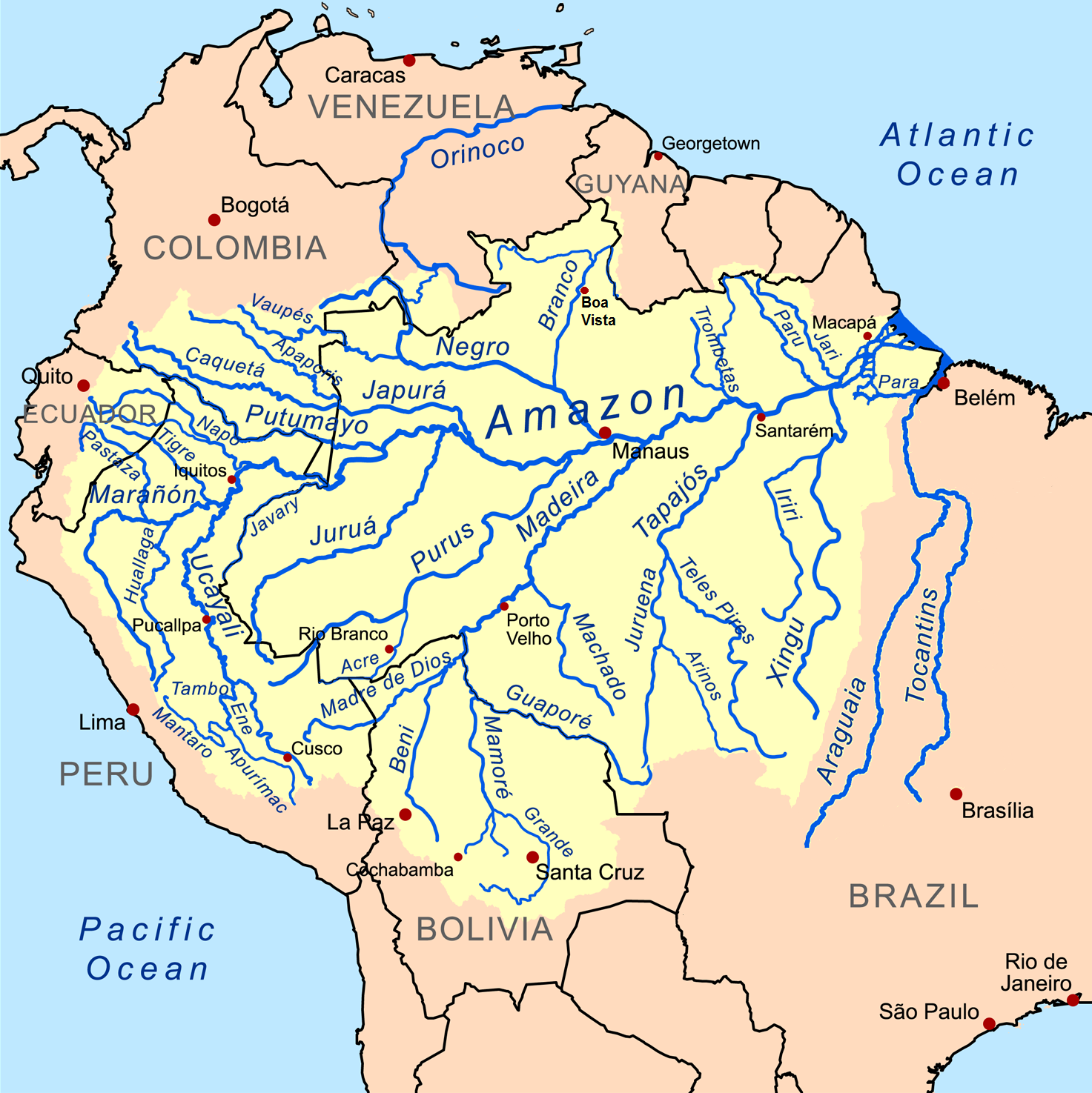
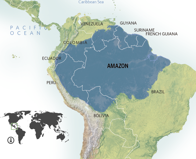
The sheer scale of the Amazon Basin, encompassing over 7.05 million square kilometers across nine South American countries, makes it one of the most challenging environments to map and monitor comprehensively. Traditional cartography alone is insufficient; modern geospatial technologies provide the “eyes in the sky” and the analytical frameworks necessary to truly grasp its immense presence and intricate changes. These tools not only tell us where the Amazon Basin is, but also what it is, and how it is evolving.
Satellite Imaging and Remote Sensing: The Eyes in the Sky
Satellite technology serves as the primary instrument for understanding the Amazon Basin’s vastness and fluidity. Orbiting satellites equipped with advanced sensors continuously collect data across various electromagnetic spectra, allowing scientists and conservationists to track phenomena invisible to the naked eye. High-resolution optical imagery from satellites like Landsat, Sentinel, and Planet Labs provides stunning visual data, revealing the basin’s expansive rainforests, intricate river networks, and diverse land uses. These images are crucial for defining the precise geographical boundaries of the Amazon, identifying its constituent countries (Brazil, Peru, Ecuador, Colombia, Venezuela, Bolivia, Guyana, Suriname, and French Guiana), and understanding the distribution of its distinct ecosystems.
Beyond mere visualization, remote sensing goes deeper. Synthetic Aperture Radar (SAR) systems, for instance, can penetrate dense cloud cover and forest canopies, offering invaluable data even during the Amazon’s rainy seasons. This capability is critical for monitoring illegal mining operations, logging activities, and infrastructure development that often occur under cover or in remote, inaccessible areas. By comparing sequential satellite images, researchers can quantify deforestation rates, track changes in river courses, identify areas of drought or flooding, and monitor the spread of agricultural frontiers. This real-time, comprehensive data fundamentally alters our ability to understand where human impacts are most pronounced and where conservation efforts are most urgently needed.
GIS and Data Visualization: Mapping the Unseen Depths
Geographic Information Systems (GIS) provide the crucial platform for integrating, analyzing, and visualizing the immense datasets generated by satellite imaging and other sources. GIS technology allows experts to layer different types of spatial information – from topographical maps and river networks to biodiversity hotspots, indigenous territories, and land use classifications. This multi-layered approach helps to paint a holistic picture of the Amazon Basin, moving beyond a simple outline to reveal its underlying complexities.
For instance, a GIS map can simultaneously display areas of high biodiversity alongside the presence of protected areas, historical deforestation patterns, and the proposed routes of new roads or dams. This visual synthesis empowers researchers, policymakers, and local communities to make informed decisions. It helps answer “where” in a nuanced way, by highlighting where conflicts between development and conservation are most likely to arise, where critical habitats are located, and where vulnerable populations reside. Advanced data visualization tools, often integrated within GIS platforms, further enhance this understanding, making complex spatial relationships intuitive and accessible, which is vital for effective communication and advocacy.
Drone Technology for Micro-Mapping and Local Monitoring
While satellites offer a macro view, drones provide invaluable micro-level insights, bridging the gap between vast aerial surveillance and ground-level observation. Unmanned Aerial Vehicles (UAVs) equipped with high-resolution cameras, thermal sensors, and even LiDAR (Light Detection and Ranging) technology can capture extremely detailed data over specific, smaller areas. For conservation efforts, drones are deployed to map individual tree species, monitor wildlife populations with minimal disturbance, and conduct precise assessments of forest degradation.
For indigenous communities living within the basin, drones offer a powerful tool for self-determination. They can use this technology to map their ancestral lands, document incursions by illegal miners or loggers, and provide irrefutable evidence for land claims. This localized application of technology helps answer “where” with hyper-accuracy, allowing for targeted interventions and empowering local guardians of the forest to protect their specific corners of the Amazon Basin. The flexibility and cost-effectiveness of drones, compared to manned aircraft, make them an increasingly vital asset in the basin’s ongoing monitoring and protection.
AI and Machine Learning: Unlocking the Basin’s Secrets
Beyond merely collecting and displaying data, the true power of technology in understanding the Amazon Basin lies in its ability to process and interpret vast, complex information. Artificial Intelligence (AI) and Machine Learning (ML) algorithms are transforming raw data into actionable intelligence, revealing patterns, predicting future scenarios, and helping us comprehend the deeper “secrets” of the basin that might otherwise remain hidden.
Predictive Analytics for Environmental Shifts
AI’s capacity for predictive analytics is revolutionizing how we anticipate and respond to environmental threats within the Amazon. By feeding historical data – including satellite imagery, climate patterns, socioeconomic factors, and infrastructure development – into sophisticated ML models, scientists can forecast deforestation hotspots with remarkable accuracy. These models can identify specific areas at high risk of illegal logging, agricultural expansion, or fire outbreaks, allowing conservation organizations and governmental agencies to deploy resources proactively. This shifts the paradigm from reactive damage control to preventive action, helping to protect areas before they are impacted. Such predictions are crucial for identifying where future battles for conservation will be fought and where interventions will have the greatest impact.
Similarly, AI models can predict the impacts of climate change on specific Amazonian ecosystems, forecasting shifts in biodiversity distribution, the spread of invasive species, or changes in water availability. This foresight allows for the strategic planning of protected areas and the development of adaptation strategies for both wildlife and human communities, ensuring that efforts are directed to where they will be most effective in mitigating future harm.
Automated Species Identification and Ecological Monitoring
The Amazon Basin is Earth’s most biodiverse region, home to millions of species, many yet undiscovered. Manual identification and monitoring of this biodiversity are monumental tasks. AI is stepping in to automate parts of this process, particularly through acoustic and visual monitoring. Sensors placed throughout the forest can continuously record sounds and images. AI algorithms can then analyze these vast data streams to identify specific animal calls (e.g., birds, monkeys, frogs), track their presence and movements, and even detect unusual sounds indicative of human activity like chainsaws or vehicles.
For visual data, AI-powered image recognition can identify individual animals from camera trap photos or classify plant species from drone imagery. This allows for large-scale, non-invasive ecological surveys that would be impossible with human effort alone. By automatically cataloging species presence and activity, AI helps to precisely map where particular species thrive, where their habitats are threatened, and where populations are declining, providing critical data for biodiversity conservation strategies.
AI-Powered Platforms for Data Integration and Collaboration
The challenges facing the Amazon Basin are multifaceted, requiring collaboration across disciplines, institutions, and nations. AI-powered platforms are emerging as crucial tools for integrating disparate datasets and fostering collaborative efforts. These platforms can ingest data from various sources – governmental reports, scientific studies, indigenous knowledge systems, citizen science contributions, and real-time sensor networks – and synthesize them into comprehensive, easily searchable databases.
By using natural language processing and advanced search algorithms, these platforms allow researchers and policymakers to quickly access relevant information about specific regions, ecological processes, or socioeconomic trends. This facilitates a more holistic understanding of the basin’s complex dynamics and helps identify where information gaps exist or where cross-sectoral interventions might be most effective. Furthermore, AI can help identify experts and stakeholders relevant to specific issues, streamlining communication and fostering international cooperation on critical conservation and development initiatives.
Digital Tools for Basin Stewardship and Connectivity
Technology isn’t just about monitoring from afar; it’s also about empowering those on the ground and fostering global responsibility. Digital tools are becoming increasingly vital for direct stewardship within the Amazon Basin, enhancing connectivity, strengthening indigenous rights, and promoting sustainable economic practices.
Empowering Indigenous Communities with Digital Literacy and Communication
Indigenous communities are the frontline guardians of the Amazon, possessing invaluable traditional ecological knowledge. Technology can significantly amplify their voices and capabilities. Mobile phones, satellite internet terminals, and solar-powered charging stations are slowly bridging the digital divide, allowing these communities to communicate with the outside world, access vital information, and participate in global dialogues about their homeland.
Digital literacy initiatives train community members to use GPS devices, smartphones, and mapping software to delineate their ancestral territories, document illegal activities, and monitor the health of their local environments. Apps designed for offline use allow them to record data on biodiversity, deforestation, or resource extraction, which can then be uploaded when connectivity is available. This empowerment helps them to clearly articulate “where” their boundaries lie, “where” their heritage is rooted, and “where” their rights are being infringed upon, making them powerful advocates for their territories and the entire basin.
Sustainable Supply Chains and Traceability via Blockchain
The global demand for products sourced from the Amazon, such as timber, minerals, and agricultural goods, can often drive unsustainable practices and illegal deforestation. Blockchain technology offers a powerful solution for establishing transparent and verifiable supply chains. By creating an immutable digital ledger, blockchain can track products from their point of origin in the Amazon all the way to the consumer.
This technology can record data at each stage – harvest location, processing, transport – ensuring that products are legally and sustainably sourced. Consumers, in turn, can scan QR codes or use apps to trace the exact “where” of their purchase, verifying its ethical journey. This transparency incentivizes sustainable practices, helps combat illegal trade, and provides a premium for responsibly sourced Amazonian products, linking the financial health of local communities to the ecological health of the basin.
Citizen Science Platforms and Mobile Apps for Data Collection
The sheer size of the Amazon Basin means that comprehensive data collection cannot rely solely on professional scientists. Citizen science platforms and mobile applications are democratizing data collection, allowing a global network of volunteers and local inhabitants to contribute valuable information. Apps like iNaturalist or specific conservation-focused platforms enable individuals to photograph and log species sightings, report environmental anomalies, or contribute to mapping efforts.
These crowd-sourced datasets, when verified by experts, significantly augment scientific understanding of species distribution, ecological changes, and the presence of threats. By empowering anyone with a smartphone to contribute, these platforms help to continuously update our understanding of “where” biodiversity is thriving or struggling, and “where” human impacts are most visible, engaging a global community in the stewardship of this vital region.
The Future of Amazonian Discovery: Tech’s Evolving Role
As technology continues to advance, so too will our capacity to understand and protect the Amazon Basin. The convergence of new sensors, AI breakthroughs, and enhanced connectivity promises an even more integrated and immersive understanding of this global treasure.
Advanced Sensor Networks and IoT in Rainforest Monitoring
The future will likely see the deployment of vast networks of interconnected sensors across the Amazon Basin, creating an “Internet of Things” for environmental monitoring. Miniaturized, low-power sensors embedded in trees, rivers, and the forest floor will continuously collect real-time data on temperature, humidity, rainfall, water quality, and even specific chemical compositions. Acoustic sensors will listen for a wider range of biodiversity, and seismic sensors could detect subtle ground vibrations from illegal activities. This continuous, multi-faceted stream of data will provide an unprecedented, granular understanding of the basin’s health, allowing for immediate alerts and responses to any significant environmental changes or threats. This will enable us to know exactly where critical shifts are occurring, minute by minute.

Virtual and Augmented Reality for Experiential Learning and Advocacy
While digital maps provide crucial information, Virtual Reality (VR) and Augmented Reality (AR) technologies offer immersive experiences that can transport people into the heart of the Amazon without physical travel. VR applications can simulate expeditions through the rainforest, allowing users to “walk” through diverse ecosystems, encounter virtual wildlife, and learn about the basin’s cultural and ecological significance. This powerful form of experiential learning can foster a deeper emotional connection and understanding of where the Amazon Basin is and what it represents.
AR, on the other hand, can overlay digital information onto the real world. Imagine conservationists using AR glasses to identify plant species, access real-time data on forest health, or visualize deforestation patterns directly within the landscape. For advocacy, AR could allow policymakers or global citizens to visualize the impact of distant decisions directly onto a map or even a physical model, bringing the remote Amazon into their immediate reality. These technologies will be instrumental in educating future generations, engaging global audiences, and inspiring action to protect this irreplaceable ecosystem, allowing for a profound, personal understanding of “where” this natural wonder exists and thrives.
In conclusion, “Where is the Amazon Basin?” is no longer a question answered solely by geographical coordinates. It is a dynamic inquiry addressed through the sophisticated interplay of satellites, AI, drones, blockchain, and digital community tools. Technology empowers us to map its vastness, monitor its vitality, predict its challenges, and ultimately, safeguard its future. By leveraging these innovations, humanity can move beyond mere knowledge of its location to a deep, data-driven stewardship of this planetary lifeline.
aViewFromTheCave is a participant in the Amazon Services LLC Associates Program, an affiliate advertising program designed to provide a means for sites to earn advertising fees by advertising and linking to Amazon.com. Amazon, the Amazon logo, AmazonSupply, and the AmazonSupply logo are trademarks of Amazon.com, Inc. or its affiliates. As an Amazon Associate we earn affiliate commissions from qualifying purchases.