
The ubiquitous five-digit sequence known as the ZIP code is far more than just a component of an address; it is a foundational pillar of modern digital infrastructure, silently powering countless applications, services, and analyses that shape our daily lives. While its origins lie in the humble need for efficient mail delivery, the ZIP code has evolved into a critical piece of geographic data, indispensable across the technological landscape, from e-commerce to AI-driven analytics, and even digital security. To truly understand “what is a ZIP code” in today’s interconnected world, one must look beyond its postal function and appreciate its profound impact on the digital realm.

Initially conceived by the United States Post Office Department (now USPS) in the early 1960s, the Zone Improvement Plan (ZIP) code was a revolutionary system designed to streamline the increasingly complex and voluminous mail sorting process. Before its introduction, mail sorting relied heavily on manual labor and familiarity with local areas. The advent of the ZIP code, however, introduced a standardized, numerical approach to segmenting geographic areas, enabling automated sorting and significantly boosting efficiency. What began as a logistical solution for physical mail has since transcended its original purpose, becoming a vital data point that underpins a vast array of technological innovations and digital services we often take for granted. This article delves into the technical essence of ZIP codes, exploring their structure, their pivotal role in modern software and applications, and their future relevance in an ever-evolving digital ecosystem.
The Genesis and Evolution of Geographic Data
Understanding the technical utility of a ZIP code begins with appreciating its origins and the clever design behind its structure. What started as a simple solution to a logistical challenge rapidly grew into a sophisticated system of geographic segmentation that continues to adapt to the complexities of the digital age.
From Mail Routing to Data Revolution
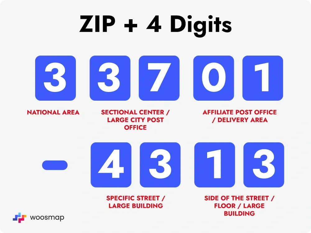
The journey of the ZIP code began in 1963, a response to a burgeoning postal system strained by increasing mail volumes. Before this, large cities were divided into “postal zones” (e.g., “New York 18, N.Y.”), a localized system that lacked uniformity and scalability. The ZIP code introduced a national, standardized numerical system. The initial five-digit code was later expanded in 1983 with ZIP+4, adding four more digits to identify a specific delivery segment within a five-digit delivery area, such as a street block, a group of apartments, or even a single high-volume receiver.
This seemingly minor change in mail routing had profound, unforeseen consequences for data management. By assigning a unique identifier to virtually every deliverable location in the U.S., the USPS created a foundational geographic database. This database, initially designed for internal postal use, quickly became an invaluable resource for businesses, researchers, and eventually, the nascent digital industry. It provided a common language for identifying locations at various granularities, from broad regions to specific neighborhoods, paving the way for data analysis and software applications far beyond simple mail delivery. The ZIP code evolved from a mere postal directive into a fundamental unit of geographic information, ready to be digitized and leveraged by emerging technologies.
Structure and Significance
The five digits of a standard ZIP code are not arbitrary; they are meticulously structured to convey specific geographical information, forming a hierarchical system that aids both human understanding and algorithmic processing.
-
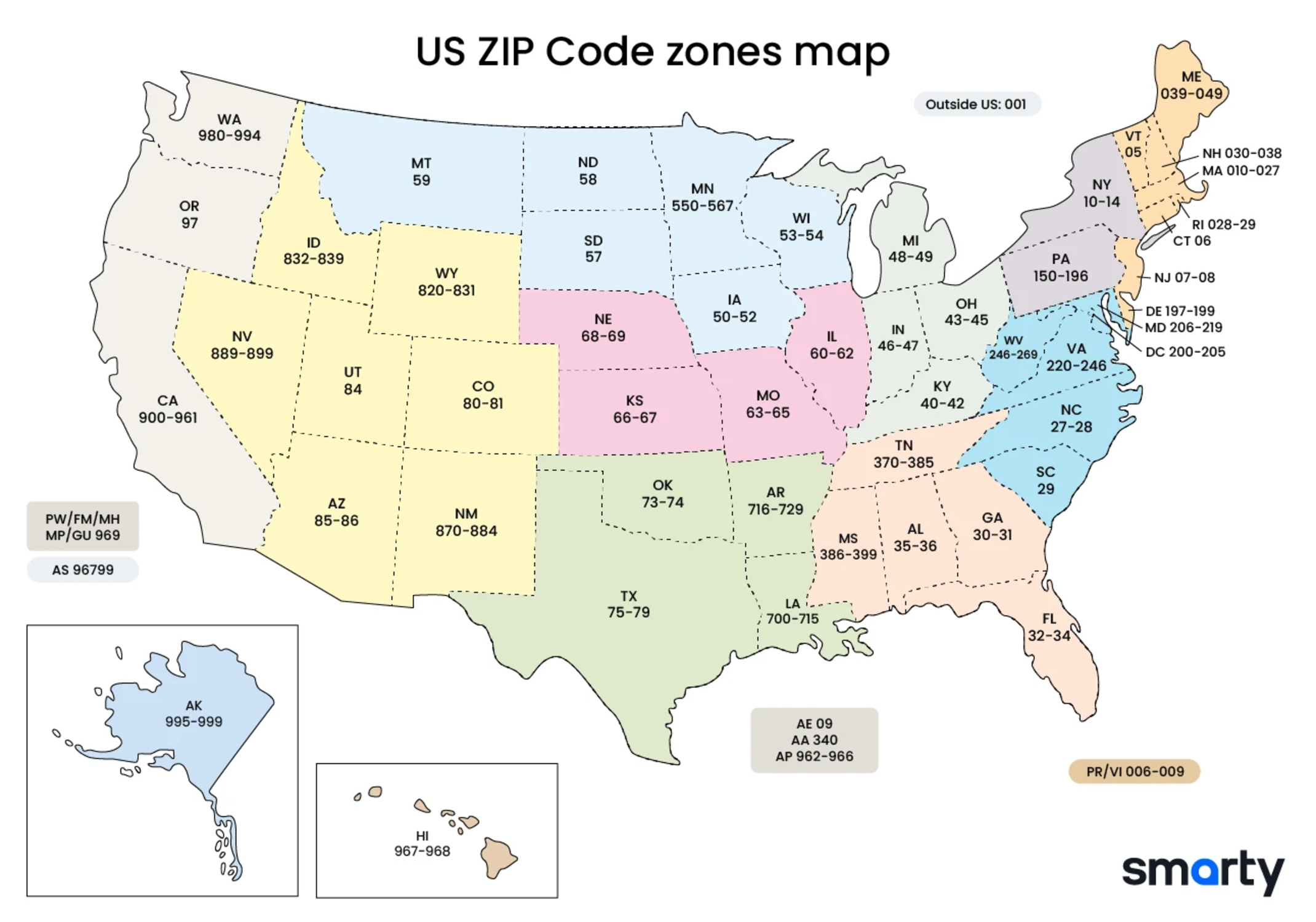
The First Digit: This identifies a broad geographical region of the U.S., ranging from 0 (Northeast) to 9 (Far West). For instance, codes starting with 0 represent states like Massachusetts and New Jersey, while codes starting with 9 cover California, Oregon, and Washington.
-
The Second and Third Digits: These together identify a sectional center facility (SCF) or a large city post office within that region. An SCF is a major sorting and distribution center that serves a specific area.
-
The Fourth and Fifth Digits: These narrow down the location further, identifying a specific delivery area or post office within the SCF’s service area. This could be a small town, a part of a city, or even a specific building or institution with high mail volume.
The subsequent four digits of the ZIP+4 code provide even finer detail, typically identifying a specific street segment, a high-rise building, or a group of post office boxes. This granular level of detail is particularly significant for automated systems, allowing for precise targeting and highly efficient data organization. For software developers, database architects, and data scientists, this structured hierarchy is incredibly valuable. It means a ZIP code isn’t just a label; it’s a coded piece of geographic information that can be systematically parsed, categorized, and analyzed, forming the backbone of countless location-aware applications.
ZIP Codes as a Cornerstone of Modern Software and Applications
In the digital age, the ZIP code transcends its role as a postal identifier to become a crucial data point that enables sophisticated functionalities across a multitude of software platforms and applications. Its simplicity belies its power in facilitating complex operations, from e-commerce logistics to advanced data analytics.
Powering E-commerce and Logistics
The modern e-commerce landscape, characterized by global reach and hyper-local delivery, would be virtually impossible without the reliable structure of ZIP codes. They are the linchpin of the entire logistical chain, ensuring that goods move efficiently from warehouse to doorstep.
-
Shipping and Delivery: Every online purchase requires a shipping address, and the ZIP code is the primary data point for calculating shipping costs, estimated delivery times, and routing packages through complex hub-and-spoke networks. Logistics software uses ZIP codes to determine optimal delivery routes, consolidate shipments, and assign packages to the correct regional distribution centers and local carriers.
-
Address Verification: Before a package even leaves the warehouse, e-commerce platforms and payment gateways utilize ZIP codes for address verification. This digital check compares the entered address against official databases, ensuring accuracy, preventing misdeliveries, and reducing fraudulent transactions. This seemingly simple check saves companies millions in lost goods and wasted shipping efforts.
-
Inventory Management: For businesses with multiple warehouses or physical stores, ZIP codes are instrumental in optimizing inventory placement. By analyzing customer demand patterns by ZIP code, companies can strategically stock products closer to their target markets, reducing shipping times and costs. This is a crucial element in modern supply chain management software.
Enhancing Geolocation and Mapping Services
While GPS provides precise coordinates, ZIP codes offer a human-readable and geographically meaningful layer for location-based services, making them intuitive and actionable for users and developers alike.
-
Navigation and Local Search: Mapping applications like Google Maps or Apple Maps leverage ZIP codes to help users find local businesses, services, or directions. When you search for “restaurants near me,” your current location (often triangulated by GPS or IP address) is cross-referenced with local ZIP code data to deliver relevant results. Similarly, inputting a ZIP code quickly centers the map on a specific area, simplifying navigation planning.
-
Ride-Sharing and Delivery Apps: Services like Uber, Lyft, DoorDash, and Instacart heavily rely on ZIP codes (or their underlying geographic polygons) for operational efficiency. They use them to define service areas, match drivers/delivery personnel with customers, calculate fares/fees, and analyze demand density in different neighborhoods.
-
Weather and Emergency Alerts: Many weather apps and emergency notification systems use ZIP codes to deliver hyper-local forecasts and alerts. By knowing a user’s ZIP code, these applications can provide highly relevant information, from severe weather warnings to public safety announcements, ensuring timely and targeted communication.
Data Analytics and Business Intelligence
Beyond operational efficiency, ZIP codes are invaluable tools for data scientists and business analysts, offering a powerful lens through which to understand markets, demographics, and consumer behavior.
-
Market Segmentation: Businesses use ZIP codes to segment their target markets. By aggregating demographic data (income, age, household size, education) and consumer behavior (purchasing habits, preferences) by ZIP code, companies can identify distinct customer groups. This allows for highly targeted marketing campaigns and product development strategies.
-
Demographic Analysis: Researchers, urban planners, and government agencies utilize ZIP code-level data for demographic studies. This helps in understanding population distribution, migration patterns, income disparities, and the allocation of resources for public services.
-
Site Selection: For businesses looking to open new physical locations (e.g., retail stores, restaurants, service centers), ZIP code analysis is critical. By examining the demographics, competition, and traffic patterns associated with different ZIP codes, companies can make data-driven decisions about the optimal placement for maximum success.
-
Predictive Modeling: In sophisticated AI tools, ZIP codes are often used as features in predictive models. For example, in real estate, models might predict property values based on the ZIP code, combined with other features. In marketing, AI can predict which ZIP codes are most likely to respond to a particular advertisement based on past performance and demographic profiles.
Leveraging ZIP Code Data for Digital Security and User Experience
The utility of ZIP codes extends beyond mere logistics and analytics; they play a crucial role in safeguarding digital transactions and personal information, while simultaneously enhancing the personalization and relevance of online experiences.
Address Verification and Fraud Prevention
In an increasingly digital world, verifying the identity and location of users is paramount for security. ZIP codes serve as a simple yet effective tool in this crucial task, acting as a first line of defense against various forms of digital fraud.
-
Confirming Identity: When you sign up for a new online service, apply for a credit card, or make a significant purchase, providing your ZIP code is often a required field. This information is cross-referenced with other data points, such as your street address and name, to confirm your identity. Banks and financial institutions rely heavily on this for “Know Your Customer” (KYC) compliance and anti-money laundering (AML) efforts.
-
Reducing Fraudulent Transactions: A common fraud detection technique involves comparing the billing ZIP code provided during an online purchase with the ZIP code associated with the credit card on file (Address Verification System – AVS). If there’s a mismatch, the transaction might be flagged for further review or outright denied. This mechanism significantly reduces credit card fraud, protecting both consumers and businesses.
-
Subscription and Age Verification: Services that offer region-specific content or require age verification (e.g., streaming services with licensing restrictions, alcohol delivery platforms) often use ZIP codes to ensure compliance with local regulations and to prevent access by unauthorized users.
Personalization and Localized Content
Beyond security, ZIP codes are fundamental to creating tailored digital experiences, making online interactions feel more relevant and engaging for individual users.
-
Tailoring Experiences: Many websites and apps ask for your ZIP code upon first use or automatically detect your location to personalize content. This could mean showing you the local weather, news headlines from your area, or special offers from businesses within your vicinity. This localization significantly enhances user engagement by delivering information that truly matters to them.
-
Targeted Advertising: The advertising industry heavily leverages ZIP code data for hyper-local targeting. Advertisers can segment audiences based on their geographic location, ensuring that promotional messages for a local store, event, or service are delivered only to users in the relevant ZIP codes. This precision targeting improves campaign efficiency and reduces wasted ad spend.
-
Community and Social Engagement: Social networking platforms and community-focused apps often use ZIP codes to connect users with local groups, events, and discussions. This fosters stronger local communities online by allowing people to interact with others in their immediate geographic area.
Emergency Services and Public Safety
In critical situations, the efficient and accurate allocation of resources is vital, and ZIP codes play an understated but crucial role in public safety technologies.
-
Directing Responders: While emergency services primarily use precise address information and GPS coordinates for dispatch, ZIP codes can serve as a valuable initial filter for routing calls and allocating resources to the correct regional dispatch centers. In large-scale emergencies, understanding the affected ZIP codes helps in quickly assessing the scope and scale of an incident.
-
Resource Allocation: Government agencies and public safety organizations use ZIP code-level data to plan for emergency preparedness, allocate resources (e.g., fire stations, police precincts, hospitals), and identify areas that may require specific interventions based on demographics or past incident data. This proactive planning is often driven by detailed geographic analysis using ZIP code boundaries.
The Future of Geographic Identification in a Digital World
As technology continues its relentless march forward, the humble ZIP code, while robust, is also evolving. Its interaction with new technologies promises even more granular and dynamic applications, though not without new challenges.
Beyond Traditional Boundaries
The digital landscape is pushing the boundaries of what constitutes a “location,” moving beyond static postal codes to more dynamic and precise forms of geographic identification.
-
Geofencing: This technology creates virtual geographic boundaries, often much smaller and more precise than a ZIP code. When a mobile device enters or exits a geofenced area, it can trigger an action, such as a push notification for a retail offer or an alert for a security system. While ZIP codes define broad areas, geofencing allows for hyper-local interactions within those areas, enabling a new level of context-aware computing.
-
Hyper-local Targeting: The future of marketing and service delivery is increasingly hyper-local, targeting individuals based on their real-time location rather than just their residential ZIP code. This involves combining ZIP code data with GPS, Wi-Fi, and beacon technologies to offer highly personalized services or advertisements relevant to where a person is right now.
-
Integration with IoT: The Internet of Things (IoT) will increasingly integrate location data, including the geographic context provided by ZIP codes, into smart devices and environments. Smart cities, for instance, will use this data for traffic management, waste collection optimization, and public safety monitoring, all informed by the geographic segments initially delineated by postal codes.
Challenges and Ethical Considerations
Despite their immense utility, the increasing reliance on ZIP codes and other geographic data also brings forth significant challenges and ethical considerations that technology must address.
-
Data Privacy: The collection and use of location data, often linked to ZIP codes, raise significant privacy concerns. Companies and governments must navigate the delicate balance between leveraging this data for improved services and protecting individual privacy. Regulations like GDPR and CCPA are attempts to address this, giving individuals more control over their geographic data.
-
Accuracy and Granularity: While ZIP codes are generally accurate for their intended purpose, they may not always reflect the precise geographic or community boundaries perceived by residents. As digital services demand ever-greater precision, the need for more granular and up-to-date geographic data will continue to grow, requiring constant maintenance and refinement of geographic datasets.
-
Digital Divide: Access to technology and location-based services is not uniform. The “digital divide,” characterized by disparities in internet access and digital literacy, means that certain communities (often identifiable by ZIP code) may be excluded from the benefits of location-aware technologies. Addressing this requires equitable infrastructure development and digital inclusion initiatives.
Conclusion
From a simple system designed to route mail in mid-20th century America, the ZIP code has profoundly transformed into a cornerstone of the digital age. It is a testament to the enduring power of structured data that a sequence of numbers, initially conceived for postal efficiency, now underpins an astonishing array of technological applications. Whether it’s enabling global e-commerce, personalizing digital experiences, enhancing public safety, or fueling sophisticated data analytics, the ZIP code remains an indispensable piece of our technological landscape.
As we look to the future, with advancements in AI, IoT, and hyper-local services, the role of geographic identification will only become more critical. While new, more granular forms of location data emerge, the ZIP code will likely retain its fundamental importance as a common, widely understood, and legally recognized geographic identifier. Its enduring legacy is a powerful reminder that even the simplest, most unassuming data points can become the robust foundations upon which complex, innovative, and essential digital systems are built. The next time you enter those five digits, remember you’re not just providing an address; you’re engaging with a piece of technology that seamlessly connects the physical world with the vast and intricate digital one.
aViewFromTheCave is a participant in the Amazon Services LLC Associates Program, an affiliate advertising program designed to provide a means for sites to earn advertising fees by advertising and linking to Amazon.com. Amazon, the Amazon logo, AmazonSupply, and the AmazonSupply logo are trademarks of Amazon.com, Inc. or its affiliates. As an Amazon Associate we earn affiliate commissions from qualifying purchases.