
The popular image of a storm chaser often involves a rugged individual, eyes fixed on a menacing sky, barreling down a desolate road. While the grit and determination are certainly real, the true essence of modern storm chasing is fundamentally rooted in an intricate web of advanced technology. Far from being a purely visceral pursuit, it is a highly technical endeavor, driven by sophisticated gadgets, powerful software, and relentless data analysis. For the contemporary storm chaser, “what they do” is inextricably linked to the tools and technological ecosystems they deploy to understand, track, and ultimately intercept severe weather phenomena. This article delves into the technological backbone that defines the activities of today’s storm chasers, exploring the critical role of innovation in forecasting, navigation, data collection, and communication.
The Technological Nerve Center: Forecasting and Navigation
At the heart of every successful storm chase lies meticulous preparation, heavily reliant on cutting-edge meteorological technology. Before a chaser even starts their engine, hours are spent analyzing complex data, making informed decisions that dramatically increase the chances of intercepting a target storm safely and effectively.
Advanced Weather Models and Forecasting Software
Modern storm chasing begins with sophisticated forecasting. Chasers utilize a suite of powerful software applications that provide access to numerical weather prediction (NWP) models. These models, run on supercomputers, simulate atmospheric conditions based on vast amounts of observational data. Key models include the Global Forecast System (GFS), the European Centre for Medium-Range Weather Forecasts (ECMWF), and various high-resolution rapid refresh (HRRR) models. Chasers don’t just look at a single model; they cross-reference multiple models, comparing their outputs to identify consistent patterns and potential discrepancies. They analyze parameters like convective available potential energy (CAPE), storm-relative helicity (SRH), shear, and dew points, often displayed through highly customizable graphical user interfaces (GUIs). Specialized software like GR2Analyst, RadarScope, or even web-based platforms like Pivotal Weather or the College of DuPage’s NEXLAB, allow for deep dives into these atmospheric variables, enabling chasers to pinpoint areas with the highest potential for severe weather development. This is not simply checking the weather; it’s a deep scientific inquiry into atmospheric mechanics, powered by complex algorithms and vast datasets.
Real-Time Radar Systems and Data Interpretation
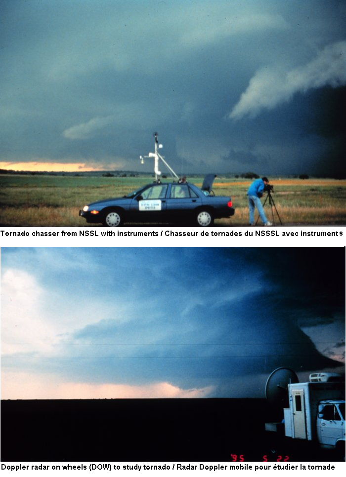
Once in the field, the most indispensable tool for a storm chaser is undoubtedly radar. High-resolution, real-time Doppler radar data provides a dynamic picture of storm structure and movement. Chasers use mobile applications and dedicated software to access NEXRAD (Next-Generation Radar) data from across the country. They interpret various radar products:
- Reflectivity: Shows precipitation intensity, helping identify storm cores, hook echoes (a signature of rotating supercells), and hail cores.
- Velocity: Indicates wind speed and direction relative to the radar, crucial for identifying rotation (mesocyclones) within a storm, a precursor to tornadogenesis. Dual-polarization radar further enhances this by providing insights into precipitation type (rain, hail, debris), which is vital for distinguishing meteorologically significant targets from ground clutter or non-tornadic circulations.
- Spectrum Width: Helps identify areas of strong turbulence or wind shear.
Interpreting these rapidly updating radar images in real-time requires significant expertise and quick decision-making under pressure. Chasers use this data to navigate safely, anticipate storm behavior, and position themselves strategically for observation or data collection, often triangulating their position relative to the storm and surrounding terrain using integrated GPS.
GPS and Advanced Mapping Applications
Accurate navigation is paramount for storm chasing, especially in unfamiliar terrain or rapidly changing weather conditions. GPS receivers, integrated into smartphones, dedicated navigation devices, and specialized vehicle setups, provide precise location data. Complementing GPS are advanced mapping applications, often overlaid with road networks, topographic data, and real-time weather information. Platforms like Google Maps, Gaia GPS, or custom-built mapping software allow chasers to plot routes, identify escape options, and visualize their proximity to storm features or critical infrastructure. Many chasers also utilize GIS (Geographic Information System) tools to layer various data points – storm tracks, road closures, terrain elevation, and even cell tower locations – to create a comprehensive operational picture. This spatial awareness, powered by satellite positioning and robust mapping software, is critical for safety and successful intercepts.
Field Operations: Instrumentation and Data Collection
The “doing” of storm chasing also involves active data collection, transforming the chaser from a mere observer into a mobile scientific platform. This requires a suite of specialized sensors and robust recording equipment.
Onboard Vehicle Technology and Mobile Weather Stations
Modern chase vehicles are often mobile command centers. Beyond basic navigation, many are equipped with advanced onboard computers and displays that integrate radar data, GPS, and custom software. Some vehicles feature roof-mounted weather stations that continuously record ambient conditions like temperature, humidity, wind speed and direction, and barometric pressure. These mobile weather stations provide hyper-local, real-time data that complements larger-scale radar observations, helping chasers understand the microclimates influencing storm development and behavior directly at their location. Data loggers within these systems capture critical information, which can later be analyzed to correlate environmental conditions with observed storm characteristics.
Specialized Probes and Sensor Arrays
For more in-depth scientific data collection, some storm chasers deploy specialized probes directly into or near severe storms.
- Mesonet/Pods: These are portable, often ruggedized, weather stations that can be rapidly deployed on tripods or stakes in the path of an approaching storm. They measure wind speed, temperature, humidity, and pressure with high frequency (e.g., every second), providing ground-level data crucial for understanding near-surface atmospheric processes in a tornadic environment.
- Dropsonde-like devices: Some advanced groups utilize small, expendable probes that can be launched into updrafts or downdrafts to gather vertical atmospheric profiles. While not as common as ground-based pods, these represent the cutting edge of in-situ data collection.
- Anemometers and Pressure Sensors: Handheld or vehicle-mounted versions are used to directly measure intense winds and rapid pressure drops, offering direct, ground-truth data often not observable by remote radar.
These instruments collect valuable information that contributes to a better understanding of storm dynamics, helping meteorologists refine models and improve warning systems.
Drones and Remote Sensing Platforms

The advent of affordable, high-quality drones has introduced a new dimension to storm chasing. Drones equipped with cameras, and sometimes even miniaturized meteorological sensors, allow chasers to gather aerial perspectives of storm structure, damage paths, and environmental interactions that would be impossible or too dangerous from the ground. They can provide unparalleled views of mesocyclone rotation, inflow bands, and the broader context of a storm’s environment. However, operating drones near severe weather presents significant technical challenges, including strong winds, precipitation, and potential interference, requiring robust, wind-resistant models and advanced flight stabilization technology. The use of drones requires careful adherence to aviation regulations and safety protocols, especially given the dynamic nature of their operating environment.
Photography and Videography Equipment
While often perceived as merely for aesthetic or documentary purposes, high-quality photography and videography equipment are crucial data-gathering tools for storm chasers. High-resolution cameras capture visual evidence of storm evolution, funnel cloud formation, tornado characteristics, and damage. Time-lapse photography can illustrate rapid changes in cloud structure and movement. Advanced cameras with high frame rates and low-light capabilities are essential for capturing events in challenging conditions. The visual data collected serves multiple purposes: documenting events for public awareness, providing ground-truth verification for radar and model data, and contributing to scientific research by allowing detailed post-analysis of storm features and behavior. Robust tripods, weatherproof housings, and long-lasting batteries are all critical components of a chaser’s visual tech arsenal.
Connectivity and Data Management in Extreme Environments
Operating in remote, often severe, environments presents unique challenges for maintaining communication and managing the vast amounts of data collected. Technology plays a pivotal role in ensuring chasers remain connected and their data is secured.
Robust Communication Systems
Reliable communication is not just about convenience; it’s a critical safety feature for storm chasers.
- Satellite Communications: When cellular networks fail or are non-existent in remote areas, satellite phones or satellite internet devices (e.g., Starlink) become indispensable. These provide a lifeline for communication with chase partners, emergency services, and for transmitting critical weather updates.
- Mobile Data Boosters and Routers: Even within cellular range, signals can be weak or unreliable. Vehicle-mounted cellular signal boosters and multi-carrier routers enhance connectivity, ensuring chasers can access real-time radar, receive urgent alerts, and communicate effectively.
- Two-Way Radios (VHF/UHF): For short-range, line-of-sight communication between chase team members, traditional two-way radios provide a robust alternative to cellular, especially in areas with poor service or during power outages.
These diverse communication tools ensure that chasers can continuously receive and transmit vital information, coordinate their movements, and call for help if needed.
Data Storage, Processing, and Dissemination
The sheer volume of data collected during a chase – radar screenshots, video footage, photographic stills, sensor readings, GPS tracks – requires robust data management.
- Ruggedized Storage: Chasers utilize durable external hard drives, solid-state drives (SSDs), and high-capacity memory cards designed to withstand vibrations, temperature fluctuations, and occasional moisture.
- Cloud Backup: Whenever connectivity allows, data is often uploaded to cloud storage services (e.g., Google Drive, Dropbox) as a crucial backup against equipment failure or loss.
- On-the-Go Processing: Laptops and tablets equipped with powerful processors are used for initial data review, quick edits of video clips for social media or news outlets, and preliminary analysis of sensor data.
- Real-time Data Feeds: Some storm chasing teams are equipped to process and transmit live video feeds or specialized sensor data directly to meteorologists, news organizations, or even public platforms, providing invaluable ground-truth observations as events unfold. This real-time dissemination relies on robust mobile internet solutions and optimized streaming technologies.
The ability to efficiently store, process, and potentially share this wealth of information is a hallmark of modern, tech-savvy storm chasing.
The Future of Storm Chasing Technology
The evolution of storm chasing is intimately tied to technological advancements. As new technologies emerge, they invariably find applications in the pursuit of severe weather, pushing the boundaries of what storm chasers “do.”
Artificial Intelligence and Machine Learning in Forecasting
The future promises even more sophisticated forecasting tools. AI and machine learning algorithms are increasingly being applied to meteorological data, capable of identifying subtle patterns and relationships that human forecasters or traditional models might miss. This could lead to even more accurate and earlier predictions of severe storm development and intensification. Chasers may soon utilize AI-powered real-time decision support systems that analyze multiple data streams and suggest optimal chase routes or observational points.
Miniaturized Sensors and IoT Integration
The trend towards miniaturization will likely lead to even smaller, more numerous, and more easily deployable sensors. Imagine a “swarm” of tiny, autonomous drones or ground-based sensors, communicating with each other and a central command unit via the Internet of Things (IoT). These networks could provide an unprecedented density of real-time environmental data across a wide area, giving chasers and meteorologists a highly detailed, 3D picture of atmospheric conditions around a storm.

Augmented Reality and Enhanced Visualization
Augmented Reality (AR) could transform the in-vehicle experience. Picture a chaser wearing AR glasses that overlay radar data, storm tracks, and critical atmospheric parameters directly onto their real-world view through the windshield. This could dramatically improve situational awareness, allowing chasers to literally “see” the invisible forces at play around a storm, enhancing both safety and data interpretation.
In conclusion, “what does a storm chaser do?” is a question that reveals a deeply technical and technologically reliant profession. From the initial forecast analysis driven by supercomputer models to the real-time interpretation of Doppler radar, the deployment of advanced sensors, and the intricate systems for communication and data management, technology empowers every facet of the storm chaser’s activities. As innovation continues, the methods and capabilities of storm chasers will undoubtedly evolve, continuing to push the frontiers of meteorological understanding and public safety, all thanks to an ever-advancing technological toolkit.
aViewFromTheCave is a participant in the Amazon Services LLC Associates Program, an affiliate advertising program designed to provide a means for sites to earn advertising fees by advertising and linking to Amazon.com. Amazon, the Amazon logo, AmazonSupply, and the AmazonSupply logo are trademarks of Amazon.com, Inc. or its affiliates. As an Amazon Associate we earn affiliate commissions from qualifying purchases.