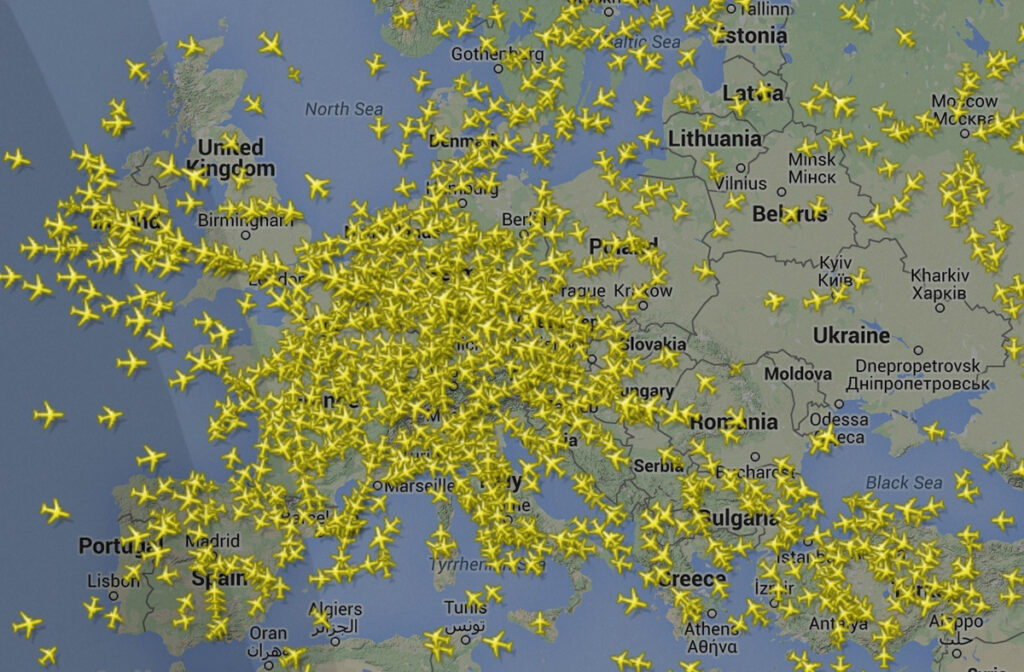
It’s a question that sparks curiosity, a seemingly simple query that, upon closer inspection, reveals a breathtaking tapestry of advanced technology, intricate data networks, and a silent, ceaseless effort to monitor every winged journey across our planet. “How many planes are in the air right now?” The immediate answer is a fluctuating number, typically ranging from 9,000 to 20,000 commercial and cargo flights at any given moment, with peak times seeing even higher figures. But the real fascination isn’t just the number itself; it’s the invisible symphony of satellites, ground stations, software algorithms, and human ingenuity that allows us to answer it with such precision, transforming the vast, once-untrackable skies into a meticulously monitored digital canvas.
From the first rudimentary air traffic control systems of the early 20th century to the sophisticated, real-time global tracking platforms of today, aviation surveillance has undergone a profound technological revolution. This evolution is driven by an unyielding demand for safety, efficiency, and interconnectedness in an era where air travel is no longer a luxury but a fundamental pillar of global commerce and personal mobility. To understand “how many planes are in the air right now” is to peer into the very heart of modern air traffic management – a complex, dynamic system built upon layers of cutting-edge technology that continuously watches over the world’s airspace.
The Unseen Network: How Air Traffic Is Monitored
Answering the seemingly simple question of how many planes are airborne is a monumental task orchestrated by a global network of interconnected technologies. This unseen infrastructure ensures that every aircraft, from a jumbo jet crossing an ocean to a small propeller plane traversing regional skies, is accounted for and safely guided.
The Pillars of Air Traffic Control (ATC) Technology
Historically, and still significantly today, air traffic control relies on various robust systems to track aircraft:
- Radar Systems: The foundational technology, radar, comes in two main forms. Primary Surveillance Radar (PSR) works by emitting radio waves that bounce off an aircraft and return to a receiver, determining its range and bearing. It doesn’t require any equipment on the aircraft itself, making it invaluable for detecting non-cooperating or unidentified targets. However, its range is limited by the curvature of the Earth and terrain. Secondary Surveillance Radar (SSR), often paired with PSR, is more sophisticated. It actively “interrogates” an aircraft’s transponder, which then replies with specific information such as altitude, a unique identification code, and sometimes speed. SSR provides clearer, more detailed data and has a greater range than PSR, but it requires a functioning transponder on the aircraft.
- Automatic Dependent Surveillance-Broadcast (ADS-B): This technology has revolutionized air traffic surveillance. Unlike radar, which “pings” an aircraft, ADS-B relies on an aircraft’s precise location, determined via GPS, being broadcast continuously to any equipped ground station or other aircraft within range. Aircraft equipped with ADS-B Out regularly transmit data packets containing their identity, position (latitude, longitude, altitude), velocity, and other critical information. This “broadcast” nature makes ADS-B significantly more accurate, offers a much wider range than ground-based radar, and provides traffic information to the cockpit (ADS-B In), enhancing pilots’ situational awareness. Its implementation has been mandated in many parts of the world, marking a significant shift towards more efficient and safer air traffic management.
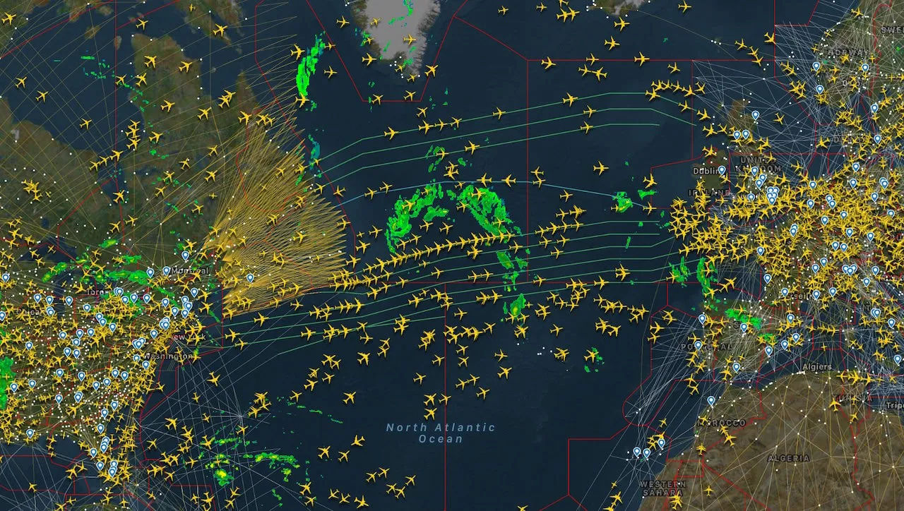
- Satellite Tracking: While ground-based ADS-B stations have greatly expanded coverage, vast oceanic and remote regions remained blind spots. This gap is being addressed by satellite-based ADS-B. Companies like Aireon have deployed constellations of low Earth orbit (LEO) satellites equipped with ADS-B receivers. These satellites pick up ADS-B broadcasts from aircraft flying anywhere in the world, including over oceans, poles, and deserts, and relay the data to ground stations. This innovation provides truly global, real-time air traffic surveillance, eliminating traditional “dark areas” and enabling more direct, fuel-efficient flight paths across previously untracked airspace.
Data Aggregation and Dissemination
The raw data generated by these diverse tracking systems – radar pings, ADS-B broadcasts, satellite relays – is just the beginning. The true magic lies in its aggregation, processing, and visualization. Specialized data providers and air navigation service providers (ANSPs) worldwide collect this disparate information. Sophisticated software fuses the data streams, filtering out noise, correlating aircraft identifications, and filling in potential gaps to create a cohesive, real-time picture of global airspace.
This processed data is then disseminated to various stakeholders. Air traffic controllers receive a highly refined view of their designated sectors, allowing them to issue precise instructions and maintain separation. Public-facing platforms like FlightAware, FlightRadar24, and AirNav RadarBox leverage this data (often with a slight delay for security reasons) to provide captivating real-time maps of global air traffic to millions of users. These platforms demonstrate the power of big data and advanced mapping technologies, making the once-exclusive world of aviation surveillance accessible to anyone with an internet connection.
Beyond the Numbers: The Impact of Real-Time Aviation Data
The ability to know “how many planes are in the air right now” is more than a mere numerical curiosity; it underpins the entire ecosystem of modern aviation. The real-time data generated by these tracking technologies has far-reaching implications, enhancing safety, optimizing operations, and empowering a wide array of users.
Enhancing Safety and Efficiency
At its core, air traffic surveillance is about safety. Real-time data allows air traffic controllers to:
- Maintain Separation: The fundamental principle of ATC is to ensure adequate separation between aircraft to prevent collisions. Precise, up-to-the-second position data allows controllers to identify potential conflicts and issue vectors or altitude changes proactively.
- Weather Avoidance: Pilots and controllers can use real-time weather overlays on their tracking displays to identify and safely navigate around severe weather phenomena like thunderstorms, turbulence, and icing conditions, enhancing passenger comfort and safety.
- Emergency Response: In the event of an in-flight emergency or an aircraft going off course, accurate real-time tracking is crucial for quickly locating the aircraft, coordinating search and rescue operations, and understanding the progression of an incident. The improved oceanic tracking from satellite ADS-B, for example, significantly reduces the risk of an aircraft disappearing without a trace.
- Optimizing Flight Paths and Fuel Consumption: With precise tracking, controllers can guide aircraft along more direct routes, avoid congested airspace, and manage arrival and departure flows more smoothly. This not only reduces flight times but also leads to significant fuel savings for airlines, lowering operational costs and environmental impact.
Operational Insights for Airlines and Airports
Airlines and airports are massive logistical operations, and real-time flight data is their lifeblood:
- Turnaround Management: Knowing the exact arrival time of an inbound flight allows ground crews at airports to prepare for its arrival, ensuring baggage handlers, fuel trucks, cleaning crews, and catering services are ready to minimize turnaround time, crucial for maintaining schedules.
- Crew Scheduling: Airlines use real-time tracking to monitor their fleet and adjust crew assignments. If a flight is delayed, they can quickly reassign crews or re-optimize schedules to prevent further disruptions and comply with crew rest regulations.
- Gate Assignments: Airports utilize live data to manage gate allocation efficiently, ensuring arriving aircraft have a vacant gate and minimizing taxi times, which can otherwise lead to lengthy delays on the ground.
- Predictive Maintenance: By tracking flight hours and operational parameters, airlines can move towards more predictive maintenance schedules, addressing potential issues before they cause costly in-service failures or delays.
Empowering Travelers and Enthusiasts
The accessibility of flight data has transformed the experience for the general public:
- Personal Travel Planning: Travelers can track their own flights, incoming connections, or the flights of loved ones, providing peace of mind and allowing them to react to delays or gate changes more effectively. This transparency has become an expected part of the modern travel experience.
- Plane Spotting and Aviation Community Engagement: For aviation enthusiasts, real-time flight trackers are indispensable tools. They can identify aircraft flying overhead, locate interesting or rare aircraft at nearby airports, and connect with a global community sharing their passion.
- Public Awareness and Transparency: The ability for anyone to see global air traffic fosters greater understanding and transparency about the aviation industry. It highlights the sheer volume of air travel, the complexity of managing it, and the continuous activity in our skies.
The Technological Evolution: From Ground Radar to Global Coverage
The journey from early, localized radar systems to today’s pervasive global tracking capabilities is a testament to continuous innovation in aviation technology. Each new development has built upon its predecessors, addressing limitations and pushing the boundaries of what’s possible.
The Rise of ADS-B
The introduction and widespread adoption of ADS-B represents a paradigm shift. Unlike traditional radar, which relies on a ground station sending out a signal and waiting for a return, ADS-B is “dependent” on the aircraft’s own navigation system (GPS) and “broadcasts” this information.
- How it Works: Each ADS-B equipped aircraft precisely determines its own position using GPS receivers. This position, along with other data like velocity and flight number, is then automatically broadcast on a dedicated radio frequency.
- Advantages Over Traditional Radar: ADS-B offers numerous benefits: higher accuracy (thanks to GPS), lower operational costs (fewer ground stations, less maintenance), and greater range for a given power output. It also provides “ADS-B In” capabilities, allowing aircraft to receive information about surrounding traffic and even weather, directly in the cockpit, significantly enhancing situational awareness for pilots.
- Mandates and Global Adoption: Recognizing these advantages, aviation authorities around the world, including the FAA in the US and EASA in Europe, have mandated ADS-B Out equipage for aircraft operating in controlled airspace, accelerating its global rollout and cementing its role as a primary surveillance technology.
Satellite-Based Surveillance
Despite the efficiency of ground-based ADS-B, large portions of the Earth’s surface – particularly oceans, deserts, and polar regions – remained outside the range of terrestrial receivers. This created “blind spots” where aircraft could essentially disappear from real-time tracking for hours.
- Overcoming Terrestrial Limitations: The solution came in the form of space-based ADS-B. Companies like Aireon partnered with Iridium Communications to host ADS-B receivers on Iridium’s next-generation LEO (Low Earth Orbit) satellite constellation.
- Aireon’s LEO Constellation and its Significance: With 66 active satellites covering the entire globe, Aireon’s system captures ADS-B transmissions from any equipped aircraft, anywhere on Earth, in near real-time. This eliminated the previous reliance on costly and limited procedural separation standards over oceans and provided a continuous, precise track of every flight, drastically improving safety and enabling more direct, fuel-efficient routes previously deemed too risky due to lack of surveillance.
- Future Potential for Truly Global Real-Time Tracking: Satellite-based ADS-B has opened the door to a future where every single flight, regardless of its location, is continuously monitored, laying the groundwork for even more advanced air traffic management concepts.
AI and Machine Learning in Aviation Analytics
The sheer volume of real-time flight data, combined with historical patterns and contextual information, provides an ideal playground for artificial intelligence and machine learning.
- Predictive Models for Delays: AI algorithms can analyze factors like weather forecasts, air traffic congestion, airport slot availability, and crew schedules to predict potential flight delays hours or even days in advance, allowing airlines and airports to take proactive measures.
- Anomaly Detection: Machine learning can identify unusual flight patterns or deviations from expected behavior that might indicate an operational issue, a security concern, or an emergency, flagging these events for human operators.
- Optimized Air Traffic Flow Management: AI can assist ATC by suggesting optimized routes, speeds, and altitudes for aircraft to minimize congestion, reduce fuel burn, and prevent bottlenecks, especially in busy terminal areas or during periods of high demand. This moves beyond simple tracking to intelligent, proactive management of the entire airspace.
Challenges and Future Frontiers in Aviation Tracking
While today’s aviation tracking systems are remarkably sophisticated, the industry faces ongoing challenges and is constantly innovating to meet the demands of an ever-growing and evolving airspace. The future promises even greater integration, autonomy, and security in air traffic surveillance.
Data Volume and Velocity
The scale of data generated by global air traffic is immense and continuously expanding. With thousands of aircraft each broadcasting multiple data points per second, the challenge is enormous.
- Managing Petabytes of Real-Time Data: Data platforms must be robust enough to ingest, process, store, and analyze petabytes of information flowing in at extremely high speeds. This requires scalable cloud infrastructure, advanced database technologies, and efficient data pipelines.
- Ensuring Low Latency and High Reliability: For air traffic control, delays in data processing can have critical safety implications. Systems must deliver information with minimal latency to ensure controllers and pilots have the most up-to-date picture of the airspace. Furthermore, the reliability of these systems must be near perfect, with built-in redundancies to prevent outages.
Security and Resilience
As aviation tracking becomes increasingly digitized and interconnected, the vulnerability to cyber threats also increases.
- Protecting Critical Infrastructure from Cyber Threats: The systems that monitor air traffic are critical national infrastructure. Protecting them from cyberattacks, data breaches, and malicious interference is paramount. This includes securing networks, encrypting data, and implementing robust access controls.
- Redundancy in Tracking Systems: To enhance resilience, aviation authorities employ multiple, often overlapping, tracking technologies. If one system (e.g., ground radar) fails, others (e.g., ADS-B, satellite) can continue to provide surveillance, ensuring continuity of service and maintaining safety.
Integration with Unmanned Aerial Systems (UAS)
The proliferation of drones, from recreational quadcopters to large commercial delivery UAVs, presents a new and complex challenge for air traffic management.
- Tracking Drones in Controlled Airspace: Integrating unmanned aerial systems (UAS) safely into airspace traditionally reserved for manned aircraft requires new tracking paradigms. Drones, especially smaller ones, often lack traditional transponders or ADS-B capabilities, making them difficult to detect and track with existing systems.
- UTM (UAS Traffic Management) Systems: The development of UAS Traffic Management (UTM) systems is crucial. These are envisioned as independent but interoperable systems that can manage drone operations at lower altitudes, providing services like flight planning, conflict avoidance, and real-time tracking for a multitude of diverse drone types.
- Harmonizing Manned and Unmanned Air Traffic: The ultimate goal is a fully integrated airspace where manned and unmanned aircraft can operate safely and efficiently alongside each other, leveraging advanced communication, navigation, and surveillance technologies tailored to their specific operational needs and capabilities.

Conclusion
The question “how many planes are in the air right now?” opens a window into one of the most remarkable technological achievements of our time. It’s a number that defies a static answer, an ever-shifting figure that is precisely quantifiable thanks to an intricate web of radar, ADS-B, and satellite technologies. This invisible symphony of data collection, aggregation, and analysis transforms the immense volume of airspace into a meticulously managed domain, ensuring that thousands of flights can crisscross the globe simultaneously with unprecedented levels of safety and efficiency.
The journey from ground-based radar to satellite-powered global surveillance, augmented by the predictive power of AI, reflects a relentless pursuit of innovation. It underpins the very fabric of global connectivity, enabling economies to thrive and cultures to intertwine. As air travel continues to grow and new forms of aerial mobility emerge, the technologies that track and manage our skies will evolve further, becoming even more integrated, intelligent, and ubiquitous. The silent, intricate dance of technology making global air travel possible is not just about counting planes; it’s about connecting the world, one precisely tracked flight at a time.
aViewFromTheCave is a participant in the Amazon Services LLC Associates Program, an affiliate advertising program designed to provide a means for sites to earn advertising fees by advertising and linking to Amazon.com. Amazon, the Amazon logo, AmazonSupply, and the AmazonSupply logo are trademarks of Amazon.com, Inc. or its affiliates. As an Amazon Associate we earn affiliate commissions from qualifying purchases.