
For most of human history, looking up at a passing aircraft evoked a sense of mystery. We could identify a plane by its vapor trail or the low rumble of its engines, but its origin, destination, and identity remained unknown to anyone without a radio tower and a transponder code. Today, that mystery has been replaced by instant, granular data. With a smartphone in your pocket, the question “What’s flying over me?” is answered through a complex ecosystem of satellite networks, terrestrial receivers, and sophisticated software. This digital transformation of our airspace has turned skywatching from a niche hobby into a mainstream technological marvel.
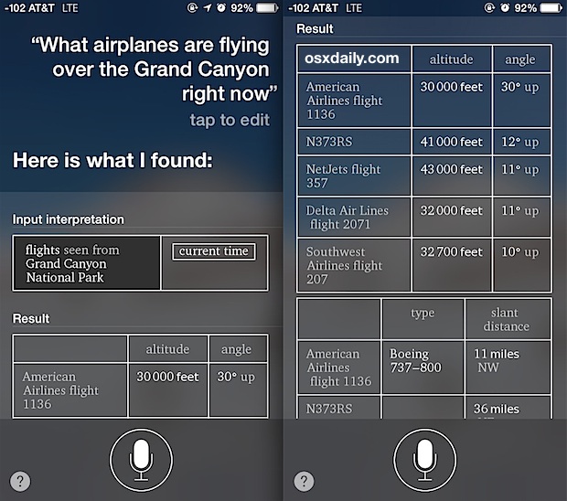
The Digital Infrastructure of the Skies: How ADS-B Works
At the heart of modern flight tracking is a technology known as Automatic Dependent Surveillance-Broadcast, or ADS-B. Unlike traditional radar, which relies on ground stations “bouncing” radio waves off the fuselage of an aircraft, ADS-B is a cooperative surveillance technology. It represents a paradigm shift from passive observation to active broadcasting.
Automatic Dependent Surveillance-Broadcast (ADS-B)
ADS-B-equipped aircraft determine their position via satellite navigation (GPS) and periodically broadcast it through a transponder. This broadcast includes the aircraft’s altitude, airspeed, and identification number. The “Automatic” part of the name means it requires no pilot or operator intervention. “Dependent” signifies that its validity depends on the data from the aircraft’s navigation system. This signal is transmitted on the 1090 MHz frequency, a standard used globally. Because these signals are unencrypted, they can be intercepted by anyone with the right equipment, which has paved the way for the consumer-grade tracking apps we use today.
Multilateration (MLAT) and Satellite Integration
Not every aircraft is equipped with the latest ADS-B Out technology, particularly older private planes or specific military hardware. In these cases, flight tracking platforms utilize Multilateration (MLAT). By measuring the Time Difference of Arrival (TDOA) of a signal at four or more separate ground-based receivers, software can calculate the precise position of the aircraft. Furthermore, the advent of space-based ADS-B—receivers placed on low-earth orbit (LEO) satellites—has eliminated “blind spots” over oceans and remote deserts, ensuring that the question of “what’s flying over me” can be answered even in the middle of the Atlantic.
The Role of Crowdsourced Receiver Networks
The massive datasets displayed on your screen are rarely the product of a single government agency. Instead, platforms like Flightradar24 and ADS-B Exchange rely on a global network of tens of thousands of volunteers. These hobbyists host small, low-cost Raspberry Pi computers connected to SDR (Software Defined Radio) antennas. These home setups capture local 1090 MHz signals and feed them into a central server via the internet. This decentralized approach to data collection is one of the greatest success stories of the modern “Internet of Things” (IoT) era.
The Best Tools for Identifying Aircraft in Real-Time
As the data became more accessible, the software used to visualize it evolved from simple lists to immersive, interactive maps. Choosing the right tool depends on whether you are a casual observer, a frequent traveler, or an aviation professional.
Flightradar24: The Global Gold Standard
Flightradar24 is arguably the most recognizable name in the industry. Its success lies in its polished user interface and its massive network of over 30,000 receivers. The app provides a high-fidelity experience, featuring 3D views that allow users to see what the pilot sees through a simulated cockpit window. For the average user asking “what’s flying over me,” Flightradar24 offers the most comprehensive database of commercial flight schedules, airline liveries, and historical flight paths.
ADS-B Exchange: The Unfiltered Alternative
While commercial apps often filter out “sensitive” flights—such as private jets belonging to high-profile individuals or certain military movements—ADS-B Exchange prides itself on being the world’s largest source of unfiltered flight data. It is the preferred tool for investigative journalists and “plane spotters” who are interested in the hardware that commercial sites might hide. Because it does not participate in the “LADD” (Limiting Aircraft Data Display) program, it provides a raw, tech-centric view of the sky.
FlightAware: Precision and Enterprise Utility
FlightAware focuses heavily on the predictive side of aviation. Utilizing “HyperFeed” machine learning algorithms, it predicts taxi times, runway delays, and arrival gates with uncanny accuracy. For tech enthusiasts interested in the intersection of Big Data and logistics, FlightAware provides a masterclass in how raw telemetry can be converted into actionable business intelligence. It integrates weather overlays and NEXRAD radar, allowing users to see how a storm cell is physically diverting the tech-heavy metal birds above them.

Augmented Reality: Turning Your Smartphone into a Radar Hub
One of the most impressive technological leaps in skywatching is the integration of Augmented Reality (AR). Instead of looking at a 2D map and trying to correlate a blue icon with a speck in the sky, AR allows users to point their camera at the heavens and see a digital overlay of the aircraft’s data.
Real-Time Visual Overlays
When you lift your phone toward a plane, the software uses the device’s GPS to determine your location and the internal magnetometer to determine which direction you are facing. It then cross-references your “field of view” with the live ADS-B data stream. Within milliseconds, an information tag appears on your screen, hovering over the physical aircraft. This tag usually displays the flight number, altitude, and destination. This seamless merger of the physical and digital worlds is a prime example of AR’s practical utility beyond gaming.
The Hardware Behind the Magic: Sensors and Gyroscopes
The accuracy of these AR features is a testament to the sophistication of modern smartphone hardware. High-frequency gyroscopes and accelerometers work in tandem with the visual API (Application Programming Interface) of the phone to ensure that the “label” follows the plane accurately, even if the user is moving. As mobile processing power increases, these apps are beginning to incorporate computer vision, which can potentially identify an aircraft’s model simply by analyzing the silhouette captured by the camera lens.
The Intersection of Privacy, Security, and Open Data
The ability for any citizen to know exactly what is flying over their head has sparked a significant debate regarding digital privacy and national security. The technology is a double-edged sword: it provides transparency, but it also removes the “clout of invisibility” once enjoyed by the elite.
The “LADD” Program and Privacy Filters
The FAA (Federal Aviation Administration) operates the Limiting Aircraft Data Display (LADD) program, which allows aircraft owners to request that their flight data be hidden from public view on websites that use FAA data feeds. However, because ADS-B signals are broadcast openly, crowdsourced networks that don’t rely on the FAA can still track these planes. This has led to a technological “arms race” between privacy-seeking jet owners and the open-source intelligence (OSINT) community.
Sky-Based OSINT in Modern Journalism
Tracking aircraft has become a cornerstone of modern investigative journalism. By monitoring the movement of government-contracted planes or private jets, researchers can track diplomatic movements, corporate mergers, or even potential human rights violations. The “What’s flying over me” query has evolved from idle curiosity into a powerful tool for holding power to account, all made possible by the democratization of transponder data and the software that organizes it.
Beyond Airplanes: Tracking the Next Generation of Aerial Objects
As we look to the future, the sky is becoming increasingly crowded with objects that aren’t traditional planes. The tech stack used to track these objects is expanding to include low-earth orbit (LEO) satellites and Unmanned Aerial Vehicles (UAVs).
Tracking the Starlink Constellation
SpaceX’s Starlink program has launched thousands of small satellites into orbit, creating “trains” of lights that often confuse observers. New tracking apps use TLE (Two-Line Element) sets—data formats used by NORAD—to track these satellites in real-time. Just as we track planes, we can now track the very satellites that may eventually provide the internet backbone for the next generation of flight tracking.

Drone Remote ID and Urban Air Mobility
The next frontier for “What’s flying over me” involves the “Remote ID” for drones. The FAA has recently mandated that drones broadcast their identity and location, essentially creating an “ADS-B for the low-altitude sky.” This will allow for the integration of delivery drones and “air taxis” into our digital maps. In the coming years, your tracking app won’t just show a Boeing 747 at 30,000 feet; it will show a delivery drone 200 feet above your neighbor’s yard, completing the total digitization of our local airspace.
aViewFromTheCave is a participant in the Amazon Services LLC Associates Program, an affiliate advertising program designed to provide a means for sites to earn advertising fees by advertising and linking to Amazon.com. Amazon, the Amazon logo, AmazonSupply, and the AmazonSupply logo are trademarks of Amazon.com, Inc. or its affiliates. As an Amazon Associate we earn affiliate commissions from qualifying purchases.