In the contemporary digital landscape, a ZIP code is far more than a sequence of numbers used by postal services to route physical mail. To the software engineer, the data scientist, and the cybersecurity expert, the Zone Improvement Plan (ZIP) code represents a foundational data point in the global tech stack. It is a vital component of geolocation algorithms, a primary key in relational databases, and a critical layer in transactional security. Understanding what a ZIP code is from a technological perspective requires looking past the paper envelope and into the complex world of geospatial data, API integration, and algorithmic logistics.

The Digital Anatomy of a ZIP Code: Data Structures and Hierarchy
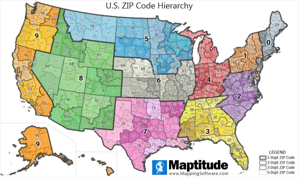
At its core, a ZIP code is a hierarchical data structure designed for efficient sorting. While it appears to be a simple integer, it functions more like an IP address for physical geography. Introduced in 1963, the system was the first major step toward automating logistics through numerical indexing. In modern software architecture, these codes are treated as strings rather than integers to preserve leading zeros—a crucial distinction for data integrity in large-scale databases.
The Boolean Logic of Logistics
The five-digit ZIP code operates on a logic of narrowing parameters. The first digit represents a specific group of U.S. states, acting as the highest level of the directory. The second and third digits represent the sectional center facility (SCF), which is the central processing hub for a region. The final two digits identify the specific post office or delivery area. This tiered structure allows sorting algorithms to process information in a “top-down” manner, significantly reducing the computational overhead required to route a package or a service request.
In programming terms, this is analogous to a nested object or a tree-based search algorithm. When a user inputs a ZIP code into a web application, the backend does not search every possible location; it filters through the hierarchy, making the search process nearly instantaneous.
ZIP+4 and the Granularity of Modern Databases
The evolution of the ZIP code into the ZIP+4 system in 1983 introduced an even higher level of granularity. These additional four digits represent specific delivery segments, such as a city block, an office building, or even a specific floor within a skyscraper. For tech platforms, this represents a leap from “neighborhood-level” data to “point-level” data.
Modern database management systems (DBMS) utilize these extended codes to perform hyper-local data analysis. When a food delivery app calculates the precise distance between a restaurant and a customer, it often relies on the ZIP+4 data to pinpoint the delivery entrance rather than just the general vicinity. This precision is what enables the high-efficiency “last-mile” delivery services that define the modern gig economy.
Geolocation and Mapping: How ZIP Codes Power the Global Tech Stack
The most prominent use of ZIP codes in technology today is in the field of geocoding. Geocoding is the process of transforming a description of a location—such as an address or a ZIP code—into numerical coordinates (latitude and longitude). These coordinates are the “language” of Global Positioning Systems (GPS) and digital mapping services.
APIs and the Geocoding Revolution
Application Programming Interfaces (APIs), such as the Google Maps Platform, Mapbox, and OpenStreetMap, serve as the bridge between a human-readable ZIP code and a machine-readable coordinate. When a user enters their ZIP code into a weather app or a store locator, an API call is triggered. The server takes the five-digit string, references it against a massive geospatial database, and returns a JSON (JavaScript Object Notation) object containing the exact geographic center (centroid) of that ZIP code.
This process is essential for front-end development. By utilizing ZIP-based geocoding, developers can create dynamic user experiences that automatically show the nearest service center or local news without requiring the user to share their precise, real-time GPS location, which many users opt out of for privacy reasons.
Spatial Data Analysis in Modern Software
Beyond simple mapping, ZIP codes are the primary units for spatial data analysis. Tech companies use this data to perform “clustering.” For example, a streaming service might analyze which ZIP codes have the highest density of high-speed fiber-optic internet to determine where to roll out 4K streaming tiers.

Software like ArcGIS or QGIS allows developers to overlay ZIP code boundaries with other data layers, such as cellular tower range or server node latency. By visualizing data through the lens of ZIP codes, tech infrastructure providers can identify “dead zones” in their networks and optimize the placement of edge computing nodes to reduce latency for the end-user.
Cybersecurity and Digital Authentication: The ZIP Code as a Security Layer
In the realm of digital security and fintech, the ZIP code serves as a ubiquitous tool for identity verification and fraud prevention. It is a “something you know” factor that adds a layer of friction for unauthorized transactions without significantly degrading the user experience.
Address Verification Systems (AVS) in E-commerce
Whenever you make an online purchase, the payment gateway uses an Address Verification System (AVS). This is a technology that checks the ZIP code provided by the user against the ZIP code on file with the credit card issuer. If the numbers do not match, the transaction is flagged or declined.
From a technical standpoint, AVS is a real-time data validation protocol. The payment processor sends a request to the bank’s server, which returns a response code (e.g., “Y” for a match, “N” for no match). This simple check is one of the most effective tools in a developer’s arsenal for preventing “card-not-present” (CNP) fraud. It ensures that even if a hacker has a card number and CVV, they cannot easily monetize it without the associated geographic data.
Fraud Detection and IP-to-ZIP Mapping
Sophisticated cybersecurity frameworks use ZIP codes in conjunction with IP addresses to detect account takeovers. Every IP address can be roughly mapped to a geographic location. If a user typically logs in from a ZIP code in New York, but an authentication attempt suddenly comes from an IP address associated with a ZIP code in London, the system’s risk-scoring algorithm will trigger a multi-factor authentication (MFA) requirement.
Developers implement these “velocity checks” and “geo-fencing” rules to protect user accounts. By comparing the “IP-to-ZIP” data, software can create a behavioral profile for a user, using geography as a biometric-like marker of legitimacy.
The Future of Zonal Data: Machine Learning and Smart City Integration
As we move toward an era of autonomous vehicles and smart cities, the “static” nature of the ZIP code is being transformed by machine learning and real-time data streams. The tech industry is no longer viewing these codes as fixed boundaries, but as dynamic zones of activity.
Predictive Logistics and AI-Driven Delivery
Machine learning models are now being trained on historical delivery data categorized by ZIP code. These models can predict peak traffic hours, common parking difficulties, and delivery success rates within specific codes. Companies like Amazon and FedEx use these predictive analytics to load delivery vans in a specific order, optimizing the route before the driver even starts the engine.
In this context, the ZIP code is a feature in a high-dimensional dataset. AI agents analyze variables like “average time spent at ZIP 94105” to adjust the estimated time of arrival (ETA) for thousands of customers simultaneously. This level of computational efficiency is only possible because the ZIP code provides a standardized framework for organizing massive amounts of location data.
From Static Codes to Dynamic Geofencing
The next frontier of ZIP code technology is the integration with IoT (Internet of Things). Smart city sensors can aggregate environmental data—such as air quality or noise levels—and tag it with a ZIP code. This data is then fed into public APIs, allowing developers to build “neighborhood health” apps.
Furthermore, “geofencing” technology allows mobile apps to trigger specific actions when a device enters a certain ZIP code. While GPS is the primary driver here, ZIP codes provide the “containers” for these fences. As we look to the future, the ZIP code will likely evolve from a delivery tool into a comprehensive data envelope that houses information about the digital and physical health of a community, served through high-speed 5G networks and processed by edge-computing algorithms.
In conclusion, a ZIP code is not merely a postal relic; it is a sophisticated piece of digital infrastructure. It is the language through which software communicates with the physical world, enabling everything from secure e-commerce to the precise geocoding of the global map. As technology continues to advance, our reliance on this 60-year-old numerical system only deepens, proving that some of the most powerful tools in the tech world are those that successfully bridge the gap between the physical and the virtual.
aViewFromTheCave is a participant in the Amazon Services LLC Associates Program, an affiliate advertising program designed to provide a means for sites to earn advertising fees by advertising and linking to Amazon.com. Amazon, the Amazon logo, AmazonSupply, and the AmazonSupply logo are trademarks of Amazon.com, Inc. or its affiliates. As an Amazon Associate we earn affiliate commissions from qualifying purchases.