
For decades, the question “what weather is it going to be today” was answered by a quick glance at a morning newspaper or a localized television broadcast featuring static maps and general predictions. Today, that same question triggers a complex symphony of high-performance computing, artificial intelligence, and global sensor networks. The transition from general regional forecasts to hyper-local, minute-by-minute predictions represents one of the most significant triumphs of modern software engineering and data science.
The technology behind weather forecasting has moved far beyond simple thermometers and barometers. We are now in an era where atmospheric fluid dynamics are simulated on massive supercomputer clusters, and machine learning models can predict a rainstorm’s arrival at a specific street corner with startling accuracy.

The Computational Power of Global and Regional Modeling
At the core of every weather app on your smartphone are Numerical Weather Prediction (NWP) models. These are massive software programs that simulate the Earth’s atmosphere by solving complex mathematical equations based on the laws of physics, fluid dynamics, and thermodynamics.
The GFS and ECMWF: The Titans of Global Data
The two most prominent models that dictate global forecasting are the Global Forecast System (GFS), operated by the National Oceanic and Atmospheric Administration (NOAA), and the European Centre for Medium-Range Weather Forecasts (ECMWF), often referred to as the “Euro model.” These models process petabytes of data daily, ingested from satellites, weather balloons, and ocean buoys.
The ECMWF is widely considered the gold standard due to its high resolution and sophisticated data assimilation techniques. It divides the world into a grid; the smaller the grid squares, the more accurate the forecast. Recent upgrades in supercomputing hardware have allowed these models to shrink their grid sizes from 50 kilometers down to 9 kilometers, providing a much higher degree of granularity for regional predictions.
High-Resolution Rapid Refresh (HRRR) and Nowcasting
While global models look at the long term, “nowcasting” is the tech that tells you it will start raining in seven minutes. This relies on high-resolution models like the HRRR. This model updates hourly and uses a 3-kilometer grid. It is specifically designed to handle rapidly changing conditions, such as the development of thunderstorms or sudden shifts in wind speed. The software architecture of HRRR is optimized for speed, ensuring that by the time a sensor picks up a change, the updated forecast is already pushed to the cloud and available on your device.
Artificial Intelligence: The New Frontier in Predictive Analysis
While traditional NWP models rely on physics-based equations, a new wave of weather technology is emerging that relies strictly on data: Artificial Intelligence and Machine Learning (ML). This shift is revolutionizing how we interpret “what weather is it going to be today” by significantly reducing the time and energy required to generate a forecast.
DeepMind’s GraphCast and AI Speed
Google’s DeepMind recently introduced GraphCast, an AI model that can predict weather variables up to 10 days in advance in under a minute. In comparison, traditional models running on supercomputers can take hours to produce the same results. GraphCast uses a “graph neural network” that has been trained on decades of historical weather data. Instead of calculating the physics of every air molecule, it recognizes patterns in how weather systems have historically moved and evolved.
This AI-driven approach is particularly effective at identifying extreme weather events, such as hurricane tracks or atmospheric rivers, providing more lead time for emergency responses. The integration of AI doesn’t replace traditional physics-based models but rather complements them, acting as a high-speed verification layer that can identify anomalies faster than human meteorologists.
Neural Networks for Hyper-Local Precision
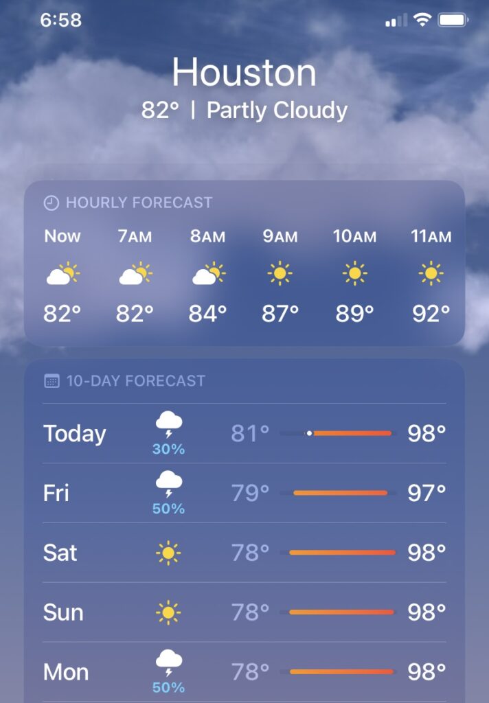
Consumer-facing apps like AccuWeather and The Weather Channel use proprietary ML algorithms to bridge the gap between a 9-kilometer model and your specific GPS coordinates. These neural networks take the broad model data and adjust it based on “micro-factors” such as urban heat islands, local topography, and historical biases in the model’s performance for that specific area. This is why two different weather apps might give you slightly different answers for the same location; their underlying AI “interprets” the raw data differently.
The Internet of Things (IoT) and the Crowdsourced Atmosphere
The accuracy of a forecast is only as good as the data fed into it. One of the most significant tech trends in meteorology is the decentralization of data collection. We are no longer solely dependent on government-run weather stations.
Your Smartphone as a Weather Station
Most modern smartphones are equipped with barometric pressure sensors. While originally included to help GPS determine altitude, this hardware has become a goldmine for meteorologists. Software like Apple’s WeatherKit or the crowdsourced platform Weather Underground can aggregate pressure readings from millions of devices simultaneously. This creates a real-time, high-density map of atmospheric pressure changes, which is a key indicator of approaching storm fronts.
Personal Weather Stations (PWS) and Smart Home Integration
The rise of consumer-grade IoT weather hardware has expanded the global sensor mesh. Systems like Netatmo, Tempest, and Ambient Weather allow users to install professional-grade sensors in their backyards. These devices connect to the internet via Wi-Fi and upload live data to global networks.
For the tech-savvy consumer, this data isn’t just for viewing on a screen; it’s part of a broader smart home ecosystem. Using platforms like Home Assistant or IFTTT (If This Then That), users can automate their homes based on precise local conditions. For example, if the local sensor detects a specific UV threshold, smart blinds automatically close to conserve energy. This is the practical application of weather tech: moving from “knowing” the weather to “reacting” to it automatically.
Hardware Revolution: From Supercomputers to CubeSats
Behind the software lies the physical infrastructure that makes modern forecasting possible. We are seeing a massive shift in both the computing power on the ground and the satellite technology in orbit.
GPU Acceleration in Meteorology
Traditionally, weather models ran on Central Processing Units (CPUs). However, the parallel processing nature of weather simulations is perfectly suited for Graphics Processing Units (GPUs). Tech giants like NVIDIA are now working with meteorological agencies to port their codebases to GPU-accelerated architectures. This shift allows for more simulations to run simultaneously (known as ensemble forecasting), which provides a better understanding of the probability of different weather outcomes.
The Rise of Microsatellites and CubeSats
In the past, weather satellites were the size of school buses and cost billions of dollars. The current trend is toward “SmallSats” and “CubeSats”—satellites no larger than a shoebox. Companies like Spire Global and Planet operate constellations of these small satellites that use “radio occultation” to measure the atmosphere.
By observing how GPS signals from other satellites are bent as they pass through the Earth’s atmosphere, these CubeSats can calculate temperature, pressure, and humidity profiles with incredible precision. Because these constellations consist of dozens or hundreds of satellites, they provide much more frequent updates than a single large geostationary satellite, ensuring that the “current conditions” on your app are truly current.
Digital Security and Data Privacy in Weather Apps
While the technology provides immense value, the “what weather is it going to be today” query often comes with a hidden cost: digital privacy. Weather apps are notorious in the tech industry for being data-hungry, often requesting constant access to high-precision location data.
The Location Data Economy
To provide a hyper-local forecast, an app needs to know where you are. However, many apps have been caught selling this granular location history to third-party data brokers and advertisers. From a digital security perspective, it is crucial to understand the “least privilege” principle. Users should opt for apps that offer “Approximate Location” settings (introduced in iOS and Android updates) or those that use on-device processing to handle location data without uploading it to a central server.
Protecting Your Digital Footprint
When selecting a weather tool, the “tech-first” approach involves looking for transparency reports and data-handling policies. Apps that utilize the Apple WeatherKit API or the OpenWeatherMap API often have more standardized privacy controls. Furthermore, utilizing decentralized or open-source weather platforms can mitigate the risk of your movement patterns being weaponized by the ad-tech industry. As we move toward more integrated AI assistants, the security of this data becomes even more paramount, as your “daily routine” can be easily inferred from the weather queries you make at specific times and places.
The question of “what weather is it going to be today” is no longer a simple inquiry. It is the end product of a massive technological pipeline that spans from the depths of the ocean to the vacuum of space, processed by some of the most advanced AI and hardware ever built. As these technologies continue to converge, our ability to predict, adapt to, and harness the elements will only become more precise.
aViewFromTheCave is a participant in the Amazon Services LLC Associates Program, an affiliate advertising program designed to provide a means for sites to earn advertising fees by advertising and linking to Amazon.com. Amazon, the Amazon logo, AmazonSupply, and the AmazonSupply logo are trademarks of Amazon.com, Inc. or its affiliates. As an Amazon Associate we earn affiliate commissions from qualifying purchases.