On January 4, 2007, the Red Planet was not merely a distant celestial body; it was a bustling laboratory of cutting-edge technology. While the world on Earth was witnessing the dawn of the smartphone era and the expansion of social media, millions of miles away, a fleet of sophisticated machines was redefining our understanding of the solar system. To ask what Mars was “doing” on this specific date is to delve into a masterclass of aerospace engineering, remote sensing, and autonomous software management.
This date represents a pivotal moment in the “Golden Age” of Martian exploration. On January 4, 2007, NASA’s Spirit and Opportunity rovers were well into their extended missions, and the Mars Reconnaissance Orbiter (MRO) was beginning to revolutionize planetary imaging. The technology active on that day laid the groundwork for every AI-driven mission we see today, from the Perseverance rover to the Ingenuity helicopter.
The Engineering Marvel of the Mars Exploration Rovers (MER)
By January 4, 2007, the Spirit rover (MER-A) was celebrating a significant milestone: its third anniversary on the Martian surface. Originally designed for a 90-day mission, the rover’s survival until 2007 was a testament to robust hardware engineering and innovative power management.
The Hardware Resilience of Spirit at Gusev Crater
On this specific day, Spirit was located at a feature known as “Home Plate” within the Gusev Crater. The tech behind this exploration was centered on its Mobility System. Each of Spirit’s six wheels had its own motor, allowing the rover to navigate the treacherous, sandy terrain that would have immobilized lesser machines. On January 4, engineers were utilizing the rover’s robotic arm—the Instrument Deployment Device (IDD)—to place sensors against volcanic rock formations.
The primary technological challenge in 2007 was power. Mars was approaching its winter, and dust accumulation on solar panels was a constant threat. The engineers used “cleaning events”—natural wind gusts—to clear the panels, but the tech-driven solution was “deep sleep” modes. On January 4, the software protocols managed the rover’s internal heaters with surgical precision to ensure the battery didn’t freeze during the -100°C Martian nights.
Software Resilience: Coding for the Martian Environment
The rovers operated on a radiation-hardened 20 MHz RAD6000 CPU, a processor that seems primitive by modern standards but was the pinnacle of reliability in 2007. The operating system, VxWorks, allowed for real-time multitasking. On January 4, the software was tasked with processing images from the Panoramic Camera (Pancam) and the Microscopic Imager. This involved on-board data compression—using the ICER wavelet-based image compressor—to ensure that the limited bandwidth of the Deep Space Network (DSN) wasn’t overwhelmed by raw data.
January 4, 2007: Spirit’s Technological Deep Dive at “Home Plate”
While the Opportunity rover was traversing the Meridiani Planum, Spirit was performing intensive geological “tech work” at the Home Plate plateau. This site was suspected to be an ancient volcanic explosion vent, and the technology deployed on January 4 was crucial in confirming this hypothesis.
Investigating “Home Plate” with Spectrometers
The rover utilized its Alpha Particle X-Ray Spectrometer (APXS) and the Mössbauer Spectrometer to analyze the chemical composition of the soil. On January 4, the tech team on Earth was analyzing data that showed high levels of silica in the vicinity—a discovery made possible by Spirit’s “mini-TES” (Miniature Thermal Emission Spectrometer). This instrument could identify minerals from a distance by measuring their infrared radiation. The integration of these tools allowed the rover to act as a mobile laboratory, proving that the technology of 2007 was already capable of detecting signs of past hydrothermal activity.
Data Transmission: Relaying Information Across the Void
One of the most impressive tech feats occurring on January 4, 2007, was the communication relay. Spirit did not always talk directly to Earth. Instead, it used its Ultra High Frequency (UHF) antenna to transmit data to the Mars Odyssey orbiter passing overhead. Odyssey then acted as a high-tech router, beaming the data back to the Deep Space Network’s giant dishes in California, Spain, and Australia. This “interplanetary internet” protocol ensured that high-resolution images and sensor data reached scientists with minimal packet loss, despite the massive distance and signal delay of approximately 10 to 20 minutes.
The Orbital Perspective: MRO and the High-Tech Eye in the Sky
While the rovers were busy on the ground, the Mars Reconnaissance Orbiter (MRO) was performing its primary science phase in January 2007. MRO represented a massive leap in orbital technology, carrying instruments that provided a resolution never before seen from space.
HiRISE: The Most Powerful Camera Ever Sent to Another Planet
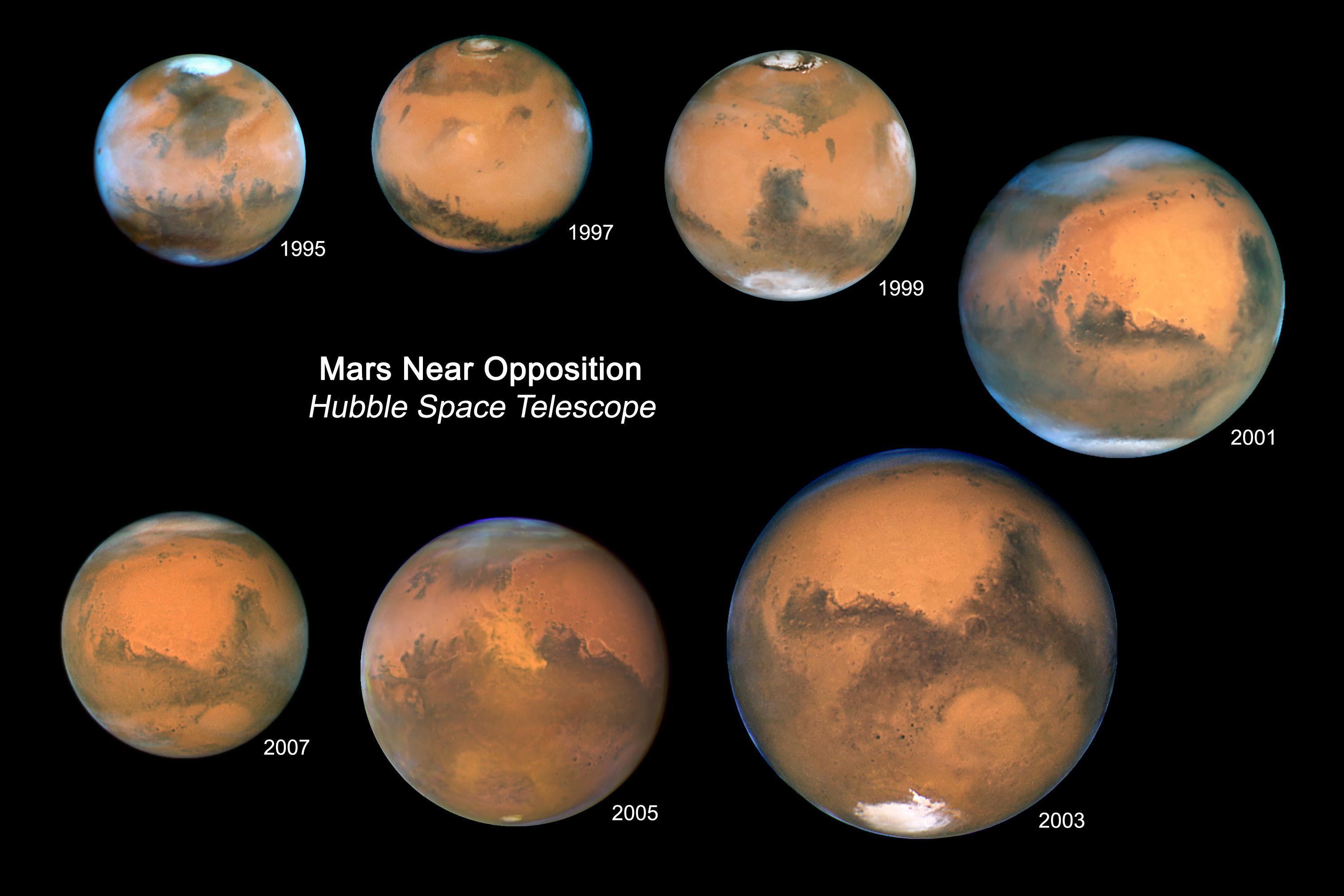
The High-Resolution Imaging Science Experiment (HiRISE) camera was the centerpiece of MRO’s technological arsenal. In early 2007, HiRISE was capturing images with a resolution of 30 centimeters per pixel. To put this in perspective, this technology allowed scientists to see individual rocks the size of a dinner plate from an altitude of 300 kilometers.
On January 4, 2007, MRO’s data buffers were working overtime. The camera used a 0.5-meter primary mirror and 14 CCD detectors. The sheer volume of data generated by HiRISE required a specialized telecommunications system called the X-band high-gain antenna. This tech allowed MRO to transmit data at rates of up to 6 megabits per second—blazing fast for 2007 space tech—enabling the creation of the first high-definition 3D maps of the Martian surface.
Precision Mapping and Geological Analysis
Beyond imaging, MRO utilized the CRISM (Compact Reconnaissance Imaging Spectrometer for Mars) on January 4 to map the mineralogy of the planet. This instrument could “see” in thousands of colors, identifying minerals that formed in the presence of water. This technological synergy between the rovers on the ground and the orbiters above created a comprehensive data ecosystem, allowing NASA to verify ground-level findings with orbital perspectives.
The Legacy of 2007 in Modern AI and Autonomous Exploration
The technology active on Mars on January 4, 2007, served as a “beta test” for the advanced AI we use today. The limitations of that era’s hardware forced engineers to develop highly efficient algorithms that paved the way for modern autonomous systems.
From Manual Scripting to Autonomous Navigation
In 2007, the rovers were largely “commanded” through daily sequences. However, they featured early versions of GESTALT (Grid-based Estimation of Surface Traversability Applied to Local Terrain), a navigation software that allowed the rover to detect hazards like rocks or steep slopes autonomously. By January 4, 2007, Spirit had become proficient at identifying “safe” paths without constant human intervention. This early computer vision and pathfinding tech are the direct ancestors of the AutoNav systems used by the Perseverance rover today, which can navigate five times faster than Spirit ever could.
How 2007 Tech Paved the Way for Perseverance and Ingenuity
The successes and failures of January 2007 influenced the design of every subsequent Martian mission. For instance, the dust issues Spirit faced on January 4 led to the development of better dust-repellent coatings and the eventual shift toward nuclear power (RTGs) for larger rovers like Curiosity and Perseverance. Furthermore, the communication protocols established in 2007 are still the backbone of the Mars Relay Network, which now supports the Ingenuity helicopter—a machine that requires millisecond-perfect data synchronization.
The Digital Frontier: Preserving Martian Data for the Future
The “work” Mars was doing on January 4, 2007, was essentially a massive data-generation exercise. That data didn’t just stay on a NASA server; it transformed how we handle “Big Data” in the tech industry.
Cloud Computing and Global Access to Space Data
The massive influx of data from MRO and the MER rovers in 2007 necessitated new ways to store and share information. This led to the development of the Planetary Data System (PDS), a precursor to modern cloud-based data repositories. By making the data from January 4, 2007, accessible to researchers worldwide, NASA fostered a collaborative tech environment. Developers created specialized software to stitch HiRISE images together, creating virtual reality environments of Mars long before VR became a consumer tech trend.
The Longevity of Software and Hardware
Perhaps the most significant tech takeaway from this date is the concept of “longevity through software.” On January 4, Spirit was performing tasks its hardware was never meant to survive for. This was achieved through “over-the-air” (OTA) software updates beamed across space—a practice that is now standard in the automotive and tech industries (such as Tesla’s updates). The ability to fix, patch, and upgrade a machine millions of miles away remains one of the greatest technological achievements of the early 21st century.
In conclusion, January 4, 2007, was a day of intense technological activity on Mars. It was a day where hardware resilience, sophisticated remote sensing, and innovative software management converged to turn a cold, dead planet into an active site of human discovery. The rovers and orbiters active on that day were more than just cameras; they were the pioneers of the autonomous and data-driven world we live in today.
aViewFromTheCave is a participant in the Amazon Services LLC Associates Program, an affiliate advertising program designed to provide a means for sites to earn advertising fees by advertising and linking to Amazon.com. Amazon, the Amazon logo, AmazonSupply, and the AmazonSupply logo are trademarks of Amazon.com, Inc. or its affiliates. As an Amazon Associate we earn affiliate commissions from qualifying purchases.