The transformation of a landscape into a winter wonderland is not merely a seasonal aesthetic; it is a complex physical event governed by the intricate interplay of thermodynamics and atmospheric science. For the average observer, the question of “when does snow stick?” seems simple. However, for meteorologists, data scientists, and infrastructure engineers, the answer lies within a sophisticated web of sensor technology, predictive algorithms, and thermal mapping. Understanding the precise temperature at which snow begins to accumulate—and the technology we use to monitor it—is critical for everything from autonomous vehicle safety to municipal resource management.
The Physics of Adhesion: Sensors and Thermal Mapping
At its core, the point at which snow “sticks” is determined by the relationship between air temperature and surface temperature. While the freezing point of water is a fixed 32°F (0°C), the behavior of snow as it hits a surface is highly variable. Modern meteorological tech differentiates between these two layers using advanced sensing equipment.
Surface vs. Air Temperature Data
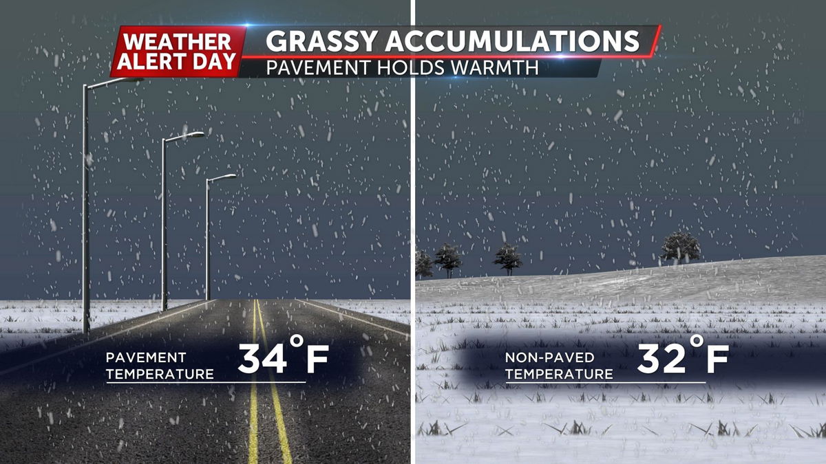
In professional meteorology, air temperature is measured at a standard height (usually 1.5 to 2 meters) to avoid the influence of the ground’s heat. However, for snow to stick, the ground itself must be at or below freezing. This is where the “lag effect” comes into play. Tech-driven weather stations now utilize ground probes—specialized thermistors buried at varying depths—to monitor how much heat the earth is retaining.
If the air is 28°F but the ground is 38°F due to a previous week of sunshine, the snow will melt upon contact. Conversely, if the ground has been “cold-soaked” by a long deep freeze, snow can stick even if the air temperature rises slightly above freezing. Capturing this data requires a network of high-precision sensors that feed real-time analytics to weather models, allowing for more accurate “accumulation start” predictions.
Infrared Thermography in Infrastructure
Beyond stationary probes, remote sensing technology has revolutionized how we understand surface adhesion. Infrared (IR) thermography allows for non-contact temperature measurement across large areas. Handheld IR thermometers and vehicle-mounted thermal sensors are now standard tools for road salt crews and civil engineers.
These devices detect the thermal radiation emitted by surfaces like asphalt, concrete, and bridge decks. Bridges are of particular interest to tech-heavy monitoring because they lack the insulating “thermal mass” of the earth beneath them, causing their surface temperature to drop much faster than the surrounding roads. This “bridge freezes before road” phenomenon is now monitored by automated thermal alert systems that trigger de-icing protocols before a single flake even falls.
AI and Machine Learning in Winter Weather Prediction
The transition from “simple forecasting” to “predictive analytics” has been fueled by the integration of Artificial Intelligence (AI) and Machine Learning (ML). Predicting when snow will stick is no longer just about reading a thermometer; it is about processing petabytes of historical and real-time data to find patterns.
Predictive Modeling for Municipal Planning
Smart cities now leverage AI-driven platforms to manage winter storms. These systems ingest data from satellite imagery, doppler radar, and localized weather stations to create “heat maps” of a city’s infrastructure. By applying ML algorithms to this data, these platforms can predict exactly which neighborhoods will see sticking snow first.
This tech allows for “predictive salting.” Rather than waiting for snow to accumulate, algorithms suggest the optimal time to apply brine based on when the “stick point” is anticipated. This precision reduces chemical runoff and saves millions in municipal budgets by ensuring that crews are deployed only when the atmospheric conditions reach the precise threshold for snow-to-surface adhesion.
Neural Networks and Microphysics
On a more granular level, the “stickiness” of snow depends on the crystal structure of the snowflake itself—a field known as cloud microphysics. High-tech weather models now use neural networks to simulate the growth of snow crystals in the atmosphere.
“Dry” snow, which forms in very cold, low-humidity air, does not stick easily; it acts more like sand. “Wet” snow, forming near the 32°F mark with high moisture content, acts as a natural adhesive. AI models help meteorologists predict the “snow-to-liquid ratio” (SLR). By understanding the SLR through complex simulation, technology can tell us if the snow will be a light dusting that blows away or a heavy, sticking layer that threatens power lines and transit.
Smart Infrastructure: Pavement Sensors and IoT
The Internet of Things (IoT) has turned our roadways into intelligent networks. The question of when snow sticks is now answered by “connected” pavement that communicates its status directly to central servers.
Road Weather Information Systems (RWIS)
An RWIS is a specialized collection of sensors designed specifically for monitoring the road environment. These stations are more robust than standard weather stations, featuring embedded pavement sensors that measure not just temperature, but also the chemical concentration of de-icing agents and the “surface state” (dry, wet, snowy, or icy).
These sensors work by measuring the electrical conductivity or the freezing point of the liquid on the road. When the system detects that the temperature is approaching the “sticking point” and the moisture levels are rising, it automatically sends an alert to transit authorities. This IoT integration ensures that the human response to sticking snow is driven by objective, real-time data rather than visual estimation.
Integrating IoT for Real-time Surface Feedback
As we move toward a world of autonomous vehicles (AVs), the tech behind sticking snow becomes even more critical. Self-driving cars rely on LiDAR and camera systems, both of which struggle when snow begins to stick to the road or the vehicle’s sensors.
Future-facing tech involves “V2I” (Vehicle-to-Infrastructure) communication. In this ecosystem, the road itself tells the car, “The surface temperature is 31°F, and snow is now adhering to the asphalt.” The vehicle can then adjust its braking distance, torque distribution, and sensor calibration. This creates a feedback loop where the tech doesn’t just monitor the snow—it adapts the entire transportation network to handle the physical reality of the weather.
Digital Tools for the Consumer: Apps and Personal Meteorological Tech
While massive infrastructure benefits from high-end sensors, the consumer tech market has also seen a surge in sophisticated tools that help individuals track the exact moment snow will begin to accumulate.
The Role of Crowdsourced Data and Hyper-local APIs
Modern weather apps like Apple Weather (integrating Dark Sky tech) and AccuWeather use hyper-local APIs to provide minute-by-minute forecasts. These apps don’t just tell you it’s snowing; they provide “ground truth” data. By utilizing the barometric sensors built into millions of smartphones, these apps create a massive, crowdsourced weather observation network.
When thousands of phones in a specific zip code detect a sudden drop in pressure and temperature, the central algorithm updates the forecast for that specific block. This allows for incredibly high-resolution “nowcasting,” telling a user that snow will start sticking on their specific driveway in approximately twelve minutes.
Wearable Tech and Professional Grade Personal Sensors
For outdoor professionals, such as ski patrollers or mountaineers, knowing when snow sticks is a matter of safety and performance. Wearable tech now includes miniaturized sensors that can be clipped to gear to monitor ambient temperature and humidity in real-time.
Furthermore, “smart” winter apparel is beginning to emerge, using integrated fibers that can sense moisture and temperature, providing data back to a smartphone app. For enthusiasts, high-end personal weather stations (like those from Tempest or Netatmo) allow users to contribute to the global weather community while receiving hyper-localized alerts on their own property’s “stick point.”
Conclusion: The Convergence of Tech and Nature
The question “what temperature does snow stick?” is no longer a matter of looking at a simple mercury thermometer. It is a data-driven inquiry that spans from the microscopic structure of an ice crystal to the massive arrays of satellites orbiting our planet.
As technology continues to evolve, our ability to predict, monitor, and react to snow accumulation will only become more precise. Through the combination of AI-driven predictive modeling, IoT-connected infrastructure, and hyper-local consumer apps, we have mastered the ability to translate the chaotic beauty of a snowstorm into actionable digital insights. In the modern era, we don’t just wait for the snow to stick; we use technology to see it coming, measure its impact, and navigate the winter world with unprecedented clarity.
aViewFromTheCave is a participant in the Amazon Services LLC Associates Program, an affiliate advertising program designed to provide a means for sites to earn advertising fees by advertising and linking to Amazon.com. Amazon, the Amazon logo, AmazonSupply, and the AmazonSupply logo are trademarks of Amazon.com, Inc. or its affiliates. As an Amazon Associate we earn affiliate commissions from qualifying purchases.