
The vast expanse of the sky, once an enigma reserved for birds and the imagination, is now an open book thanks to a remarkable convergence of modern technology. What used to be a mere flicker of light or a distant hum, prompting curious gazes and unanswered questions, can now be precisely identified, tracked, and analyzed in real-time. The query, “What planes are above me right now?” is no longer a rhetorical musing but a solvable puzzle, offering a fascinating glimpse into the intricate ballet of global air traffic. This transformation from aerial mystery to accessible data is a testament to sophisticated technological advancements, from satellite-based broadcast systems to intelligent software applications, democratizing access to aviation information for enthusiasts, professionals, and the general public alike. This article delves into the technological marvels that make real-time flight tracking possible, exploring the underlying infrastructure, the essential tools at your fingertips, the depth of insights available, and even how you can become a part of this global network.
The Invisible Infrastructure: How Real-Time Flight Data Reaches You
The seemingly magical ability to pinpoint every aircraft in the sky is not magic at all, but the result of a meticulously engineered global infrastructure. This system relies on aircraft broadcasting their own positions, ground stations receiving these signals, and powerful networks aggregating and distributing this information. Understanding these core components is key to appreciating the transparency offered by modern flight tracking.
Automatic Dependent Surveillance-Broadcast (ADS-B): The Modern Standard
At the heart of contemporary real-time flight tracking lies Automatic Dependent Surveillance-Broadcast, or ADS-B. This technology represents a significant leap forward from older radar-based systems. Instead of waiting to be pinged by ground radar, ADS-B equipped aircraft continuously broadcast their precise position, altitude, speed, heading, and identification information derived from onboard GPS receivers. These signals are transmitted on a dedicated radio frequency (1090 MHz) and can be picked up by relatively inexpensive ground-based receivers. Most modern aircraft, particularly in developed nations like the United States and Europe, are mandated to carry ADS-B Out transponders, making their movements transparent to anyone with the right equipment. This self-reporting mechanism offers significantly more accurate and frequent updates than traditional radar, creating a more complete and real-time picture of air traffic.
Traditional Radar and Multilateration (MLAT)
While ADS-B is the primary driver of public flight tracking, it doesn’t cover every aircraft or every corner of the globe. Traditional radar systems, operated by air traffic control (ATC), still play a crucial role in aviation safety and guidance, but their data is not typically publicly accessible in real-time. To fill gaps where aircraft may not be ADS-B equipped or where ground-based ADS-B receiver coverage is sparse, another technology called Multilateration (MLAT) comes into play. MLAT systems work by detecting the faint, unfiltered transponder “squawks” that all aircraft (even older ones) emit. By measuring the tiny differences in the time it takes for these signals to arrive at several geographically dispersed ground receivers, sophisticated algorithms can precisely calculate an aircraft’s position. This method effectively triangulates the aircraft’s location, extending tracking capabilities to areas and aircraft types that might otherwise be invisible to ADS-B. Together, ADS-B and MLAT form a robust, multi-layered approach to tracking virtually all significant air traffic.
The Network Effect: Global Receivers and Data Aggregation
The raw ADS-B and MLAT signals would be fragmented and localized without a powerful aggregation network. This is where the true ingenuity of modern flight tracking services shines. Thousands of individuals, aviation enthusiasts, and companies worldwide operate small, often self-built or company-provided, ADS-B receivers. These receivers pick up local aircraft transmissions and then feed this data, often via the internet, to centralized servers run by major flight tracking platforms. This creates a vast, distributed network that collectively covers huge swathes of the globe. Each receiver acts as a node, contributing its localized data to build a comprehensive, real-time map of global air traffic. The more receivers contributing data, especially in remote or less-covered areas, the more complete and accurate the global tracking picture becomes. This collaborative, community-driven approach is fundamental to the pervasive and detailed flight tracking we enjoy today.
Your Digital Window to the Skies: Leading Flight Tracking Applications
With the underlying data infrastructure in place, the next step is accessing and interpreting this information. A suite of sophisticated applications and online platforms has emerged, each offering unique features and catering to different user needs. These tools transform raw data into intuitive, interactive maps, putting the world’s airspace at your fingertips.
FlightAware: Professionalism Meets Public Access
FlightAware stands out as a robust platform that seamlessly blends professional-grade tools with accessible public features. Originating with a strong focus on aviation professionals, including pilots, airlines, and airport operations, FlightAware offers incredibly detailed predictive modeling for flight arrival and departure times, often surpassing airline estimates. Its comprehensive historical data archives are invaluable for analyzing past flight performance, understanding trends, and even investigating incidents. For the general user, FlightAware provides a clean interface to track specific flights by tail number, airline, or route, offering real-time status updates, gate information, and even ground speed. The platform also aggregates extensive airport status information, including delays, weather conditions, and active runways, making it a go-to resource for anyone concerned with air travel logistics.
FlightRadar24: The Global Real-Time Map
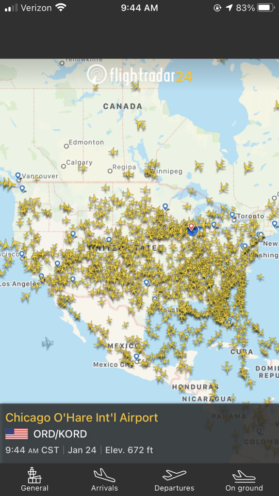
Perhaps the most recognized name in public flight tracking, FlightRadar24 has carved out a niche with its highly visual, user-friendly interface and extensive global coverage. Its interactive map is famous for displaying a vibrant tapestry of aircraft icons moving in real-time, instantly gratifying the curiosity of “what planes are above me.” FlightRadar24 boasts an impressive network of over 40,000 ADS-B receivers worldwide, many contributed by enthusiasts, ensuring broad coverage. Beyond basic tracking, it offers unique features like an augmented reality view, allowing users to point their smartphone camera at the sky and instantly identify overhead aircraft. Detailed aircraft information, historical data playback, and comprehensive filters (by airline, aircraft type, altitude, speed, etc.) make it a powerful tool for both casual observers and dedicated aviation enthusiasts who want to delve deeper into the data.
PlaneFinder and ADSBExchange: Diverse Approaches
While FlightAware and FlightRadar24 dominate, other platforms offer compelling alternatives or specialized services. PlaneFinder provides a similar comprehensive experience, often lauded for its intuitive interface and high refresh rates. It offers similar features like detailed aircraft information, historical tracking, and robust filtering options, often serving as a strong competitor for users seeking a slightly different aesthetic or feature set.
ADSBExchange, on the other hand, operates with a distinct philosophy centered on unfiltered transparency. Unlike commercial trackers that might filter out certain private or military flights, ADSBExchange prides itself on displaying all available ADS-B data. This makes it a favorite among aviation enthusiasts, journalists, and researchers interested in tracking flights that might be intentionally obscured by other services. It’s a community-driven, open-source-focused platform that prioritizes raw data access, providing a more comprehensive, albeit sometimes less polished, view of the skies. Its commitment to showing everything detected, without commercial censorship or filtering, makes it an invaluable resource for specific analytical needs and for those who believe in complete airspace transparency.
Beyond the Basics: Advanced Insights and Analytics
Modern flight tracking applications offer much more than just a moving dot on a map. They are sophisticated analytical tools, capable of revealing a wealth of information that can satisfy casual curiosity, inform complex logistical decisions, or even aid in investigative journalism. The depth of data available transforms simple tracking into comprehensive airspace analysis.
Deep Diving into Aircraft Information
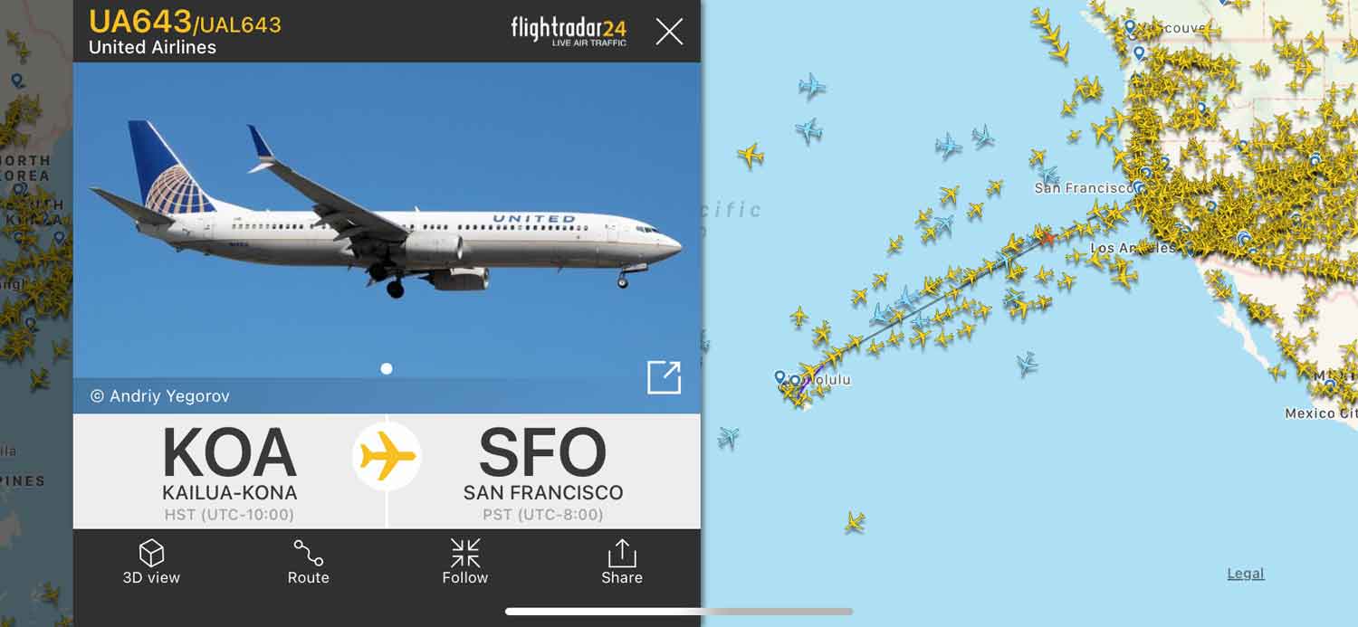
Clicking on an aircraft icon in a tracking app opens up a treasure trove of information. Beyond the obvious flight number and destination, you can often retrieve the aircraft’s unique tail number (registration), its specific aircraft type (e.g., Boeing 737-800, Airbus A320), the airline operating it, and even details like its age, specific engine types, and previous registrations. For aviation enthusiasts, this level of detail is a goldmine for “spotting” and identification. For professionals, it can be crucial for maintenance, repair, and overhaul (MRO) operations, helping to identify specific parts or service schedules based on the aircraft’s configuration and history. This granular data humanizes the impersonal dots on a map, connecting them to real machines with unique identities and histories.
Predictive Analytics and Historical Data
The power of these platforms extends beyond the present moment. Advanced algorithms analyze current flight parameters, weather conditions, and historical performance to provide highly accurate estimated times of arrival (ETAs) and identify potential delays. This predictive capability is invaluable for travelers meeting flights, logistics companies tracking cargo, and airport operators managing gate assignments. Furthermore, comprehensive historical data archives allow users to replay past flights, analyze typical flight paths for specific routes, investigate the causes of delays on particular days, or even research an aircraft’s complete operational history. This data is critical for incident investigation, performance benchmarking, and understanding long-term trends in air traffic patterns, offering insights into everything from fuel efficiency to airspace congestion.
Enhancing Situational Awareness: Weather and Airspace
To provide a truly comprehensive view of the skies, leading tracking applications integrate various layers of critical information. Real-time weather overlays, showing precipitation, wind patterns, and storm fronts, allow users to understand how atmospheric conditions might be impacting flight paths or causing turbulence. This is not only fascinating for observers but also vital for pilots, who use this data for flight planning and in-flight decision-making. Moreover, these apps often display airspace restrictions, such as Temporary Flight Restrictions (TFRs) around special events or government installations, and permanent restricted airspaces. For drone operators, pilots of general aviation aircraft, and even amateur astronomers, this contextual information is essential for ensuring safety and compliance within the complex structure of regulated airspace. The integration of these diverse data streams creates a holistic digital representation of the airspace.
DIY Sky Gazing: Building Your Own ADS-B Receiver Station
For those with a penchant for technology and a desire to contribute to the global aviation community, building a personal ADS-B receiver station is an immensely rewarding project. It transforms a passive observer into an active participant, enhancing local coverage and deepening one’s understanding of this fascinating technology.
The Appeal of Personal Contribution
The primary allure of setting up your own ADS-B receiver lies in the direct contribution to the global flight tracking network. By feeding data from your location, you enhance the coverage and accuracy of popular platforms like FlightAware and FlightRadar24, particularly benefiting regions with sparse existing receiver coverage. Beyond this altruistic aspect, it’s a fantastic hands-on hobby for tech enthusiasts. It provides a deeper insight into radio frequency reception, data processing, and network protocols, offering a practical learning experience. Furthermore, having a personal receiver often grants access to premium features on the major tracking sites as a thank-you for your data contribution, providing an enhanced viewing experience.
Essential Hardware and Software
Building an ADS-B receiver is surprisingly affordable and accessible for anyone with basic tech skills. The core hardware components typically include:
- RTL-SDR Dongle: This is a low-cost USB device, originally designed as a digital TV tuner, which can be repurposed to receive a wide range of radio frequencies, including the 1090 MHz ADS-B signal.
- Antenna: A specialized 1090 MHz antenna is crucial for optimal reception. While basic antennas can work, dedicated outdoor antennas significantly improve range and signal quality.
- Mini-Computer: A Raspberry Pi is the most popular choice due to its low power consumption, small form factor, and robust community support. Other single-board computers or even an old PC can also serve the purpose.
- Cables and Power Supply: Necessary for connecting components and powering the Raspberry Pi.
On the software side, the setup typically involves installing a Linux-based operating system (like Raspberry Pi OS) on the mini-computer, followed by specific ADS-B decoder software (such as dump1090 or ADSB-Receiver Project which is a comprehensive script to automate the setup). This software processes the raw radio signals from the RTL-SDR dongle into usable aircraft data.
Joining the Global Network: Community and Impact
Once your receiver is operational and decoding ADS-B signals, the next step is to feed this data to one or more of the major flight tracking platforms. Both FlightAware (via “PiAware”) and FlightRadar24 (via “FR24feed”) provide simple scripts and instructions to configure your Raspberry Pi to automatically send your collected data to their servers. This seamless integration means your local observations instantly become part of a global, real-time dataset. The satisfaction of seeing your receiver’s contributions highlighted on a global coverage map, often with incentives like premium subscription upgrades, reinforces the community aspect of this hobby. Your small setup, combined with thousands of others, creates a robust, distributed sensing network that collectively paints an unparalleled picture of the world’s airspace, truly embodying the power of collaborative technology.
The Broader Spectrum: Why Real-Time Air Traffic Data Matters
The ability to track planes above us in real-time extends far beyond satisfying idle curiosity or serving a niche hobby. It represents a profound technological shift with significant implications for safety, efficiency, economy, and transparency across various sectors. The data generated and disseminated by these systems plays a crucial role in the modern world.
Enhancing Aviation Safety and Efficiency
At its core, real-time air traffic data significantly enhances aviation safety. Air traffic controllers utilize this data, often from sources like ADS-B and radar, to maintain safe separation between aircraft, guide them through complex airspace, and manage traffic flow, preventing potential collisions. In emergency situations, precise, real-time position data can drastically reduce search and rescue times, improving outcomes for distressed aircraft. Furthermore, the ability to observe and analyze flight paths and performance helps in understanding near-miss incidents, identifying airspace choke points, and continually refining safety protocols. Beyond safety, real-time data contributes to efficiency by enabling optimized flight paths, reducing holding patterns, and minimizing delays, which in turn leads to lower fuel consumption, reduced emissions, and more punctual travel for passengers and cargo.
Economic and Business Applications
The economic ramifications of real-time air traffic data are substantial and diverse. In the realm of logistics and supply chain management, tracking cargo flights allows businesses to monitor the progress of critical shipments, anticipate delivery times, and react proactively to delays, thereby optimizing inventory management and customer expectations. For airlines, the data provides invaluable insights into their own fleet utilization, operational efficiency, and adherence to schedules. Aviation market analysts use aggregated data to track new aircraft deliveries, monitor fleet compositions, and assess airline performance and market share. Even in journalism and crisis monitoring, real-time flight data becomes a powerful tool. Journalists can track flights related to major news events, such as humanitarian aid missions during natural disasters or the movements of specific aircraft during geopolitical developments, adding a crucial layer of transparency and verification to their reporting.
The Future of Airspace Transparency
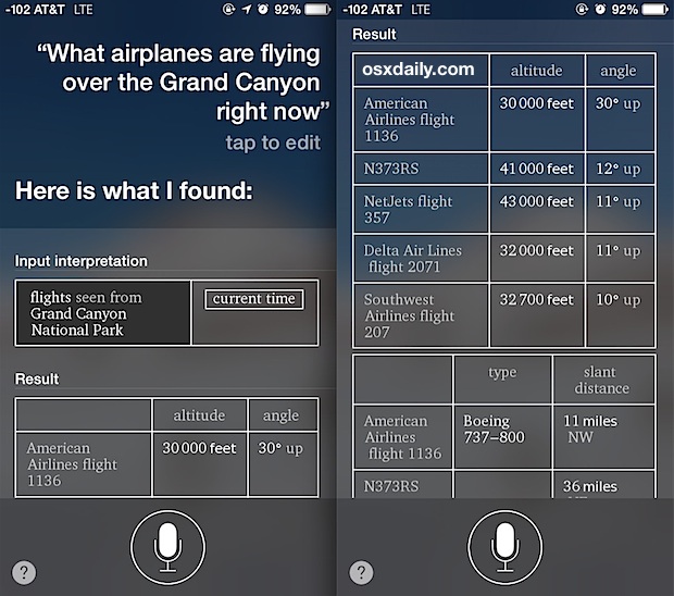
The ongoing evolution of real-time air traffic monitoring points towards an increasingly transparent and data-rich future for our skies. As drone technology proliferates, the concept of Unmanned Traffic Management (UTM) systems is emerging, which will rely heavily on real-time positional data of drones to integrate them safely into existing airspace. This will likely involve similar broadcast technologies to ADS-B, scaled for smaller, lower-flying craft. Beyond terrestrial airspace, the principles of real-time tracking are even being extended to space traffic monitoring, where the increasing number of satellites and orbital debris necessitates similar tracking and collision avoidance systems. The drive towards greater airspace transparency, fueled by ever more sophisticated sensors, data processing, and communication networks, ensures that the answer to “what planes are above me right now” will only become more detailed, more accurate, and more profoundly integrated into our daily lives and global operations.
The seemingly simple question, “What planes are above me right now?” unlocks a fascinating world of technological innovation. From the ubiquitous ADS-B broadcasts transmitted by aircraft to the intricate global network of volunteer-operated receivers, and the sophisticated software applications that aggregate and present this data, a complex ecosystem is at play. This fusion of hardware, software, and human collaboration has demystified the skies, turning fleeting glimpses into a rich tapestry of real-time information. Whether you’re a casual observer admiring the ballet of flight, an aviation professional making critical decisions, or a tech enthusiast building your own receiver, the tools to unveil the skies above you are readily available. This ongoing technological journey not only satisfies our inherent curiosity but also underpins critical aspects of modern safety, efficiency, and global connectivity, promising an even more transparent and interconnected future for our airspace.
aViewFromTheCave is a participant in the Amazon Services LLC Associates Program, an affiliate advertising program designed to provide a means for sites to earn advertising fees by advertising and linking to Amazon.com. Amazon, the Amazon logo, AmazonSupply, and the AmazonSupply logo are trademarks of Amazon.com, Inc. or its affiliates. As an Amazon Associate we earn affiliate commissions from qualifying purchases.