
The Fundamental Nature of Groundwater Reservoirs
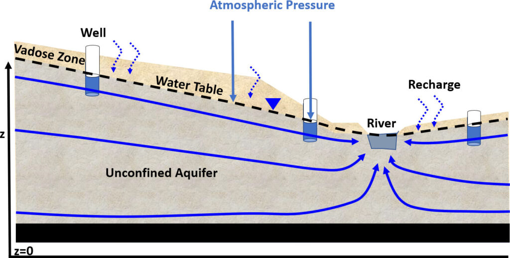
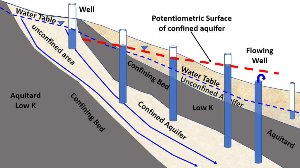
At the core of hydrological understanding lies the concept of an aquifer, a crucial subterranean layer of rock or sediment that holds and transmits groundwater. Among these, the unconfined aquifer stands out due to its direct interaction with the Earth’s surface and the atmosphere. Unlike its confined counterparts, an unconfined aquifer has no overlying impermeable layer (aquitard) to separate it from the ground surface. Its upper boundary is defined by the water table—the level below which the ground is saturated with water. This direct connection makes it particularly responsive to surface conditions, absorbing recharge directly from precipitation, snowmelt, rivers, and lakes, yet also rendering it uniquely vulnerable to surface activities.
Defining the Unconfined Aquifer
An unconfined aquifer, often referred to as a water table aquifer, is essentially a permeable geological formation that is not overlain by a confining layer. The water within it is under atmospheric pressure, and if a well is drilled into it, the water level in the well will rise to the level of the water table. This dynamic relationship means that the water table can fluctuate significantly in response to rainfall events, drought periods, and human activities like pumping. Understanding its characteristics is paramount for water resource management, agricultural planning, and urban development, especially when considering the implications of climate change and increasing water demand. Its accessibility makes it a primary source of freshwater globally, necessitating sophisticated technological approaches for its sustainable management.
Geological Formations and Characteristics
Unconfined aquifers are typically found in geological formations composed of highly permeable materials such as sand, gravel, fractured sandstone, or highly weathered granite. These materials possess a high porosity, meaning they have numerous interconnected pores or spaces that can hold water, and critically, a high hydraulic conductivity, allowing water to flow relatively freely through them. The movement of water within these aquifers is primarily driven by gravity, flowing from areas of higher water table elevation to areas of lower elevation, eventually discharging into rivers, springs, or other bodies of water. The unconsolidated nature of many unconfined aquifers also means they are often more susceptible to land subsidence if large volumes of water are extracted, reducing the structural support provided by the groundwater. This combination of direct recharge and permeability, while beneficial for replenishment, also presents significant challenges, particularly regarding the ease with which pollutants from the surface can infiltrate and contaminate the groundwater supply, underscoring the need for advanced monitoring and mitigation technologies.
Digital Eyes on Hidden Waters: Monitoring Technologies
The elusive nature of groundwater, hidden beneath the Earth’s surface, necessitates advanced technological solutions for effective monitoring. For unconfined aquifers, where the water table’s fluctuations directly reflect environmental conditions and human interaction, real-time data acquisition is crucial. Modern technology, from sophisticated sensor networks to satellite-based remote sensing, provides the “digital eyes” needed to observe these vital reservoirs. These tools not only track quantitative aspects like water levels and extraction rates but also provide qualitative data on water quality, enabling proactive management and intervention. The integration of these diverse technologies forms a comprehensive surveillance system, transforming abstract geological concepts into actionable data points for environmental scientists and resource managers.
Sensor Networks and IoT for Real-time Data
The backbone of modern unconfined aquifer monitoring lies in deploying extensive sensor networks, often leveraging the Internet of Things (IoT) paradigm. Piezometers equipped with pressure transducers are installed in monitoring wells to continuously measure groundwater levels and pressure. These sensors, along with multi-parameter probes that assess water quality (e.g., pH, conductivity, temperature, dissolved oxygen), are interconnected through wireless communication modules. Data collected is transmitted in real-time to cloud-based platforms, offering immediate insights into aquifer conditions. This continuous flow of data enables water managers to detect rapid declines in water levels indicative of over-pumping, identify sudden changes in water quality that might signal contamination, or anticipate flood risks. The benefits are profound: enhanced decision-making for irrigation scheduling, early warning systems for drought and contamination events, and optimized resource allocation, all leading to more efficient and sustainable groundwater management. Furthermore, the granularity of data from IoT networks allows for localized interventions, preventing broader impacts.
Remote Sensing and GIS Applications
Beyond on-site sensors, remote sensing technologies offer a macroscopic view of aquifer dynamics. Satellite missions, such as NASA’s Gravity Recovery and Climate Experiment (GRACE and GRACE-FO), measure subtle changes in Earth’s gravity field, which can be correlated with large-scale changes in terrestrial water storage, including groundwater within unconfined aquifers. While not providing the granular detail of individual wells, GRACE data offers invaluable regional trends, especially for vast aquifer systems. Complementing this, Geographic Information Systems (GIS) play a pivotal role in integrating, analyzing, and visualizing diverse datasets. GIS platforms are used to map aquifer boundaries, delineate recharge zones, plot monitoring well locations, analyze land use patterns, and identify potential sources of contamination. By overlaying these spatial data layers, hydrologists can understand the complex interactions between surface activities and groundwater quality and quantity. Drones equipped with hyperspectral cameras or ground-penetrating radar can further enhance this by providing high-resolution local data, detecting subtle changes in surface moisture, vegetation stress, or even subsurface structures that influence groundwater flow, making GIS an indispensable tool for spatial decision support in aquifer management.
Predictive Power: Software and AI in Aquifer Management
Understanding the current state of an unconfined aquifer is only one part of effective management; predicting its future behavior is equally critical. This is where the formidable capabilities of advanced software and Artificial Intelligence (AI) tools come into play. These technologies move beyond simple data collection, offering sophisticated analytical models that can simulate complex hydrological processes and forecast trends under various scenarios. By feeding historical and real-time data into these models, scientists and managers can gain invaluable foresight, enabling proactive strategies to mitigate risks and ensure long-term sustainability. The predictive power of these digital tools transforms groundwater management from a reactive exercise into a strategic, data-driven discipline.
Hydrological Modeling Software
Hydrological modeling software forms the cornerstone of predictive aquifer analysis. Programs like MODFLOW, developed by the U.S. Geological Survey, are widely used numerical models that simulate groundwater flow and solute transport in complex hydrogeological systems, including unconfined aquifers. These models divide the aquifer into a grid of cells and apply mathematical equations to describe water movement, interaction with surface water bodies, and the transport of dissolved substances. Users can input parameters such such as hydraulic conductivity, recharge rates, pumping schedules, and boundary conditions to simulate how the water table will respond to different stresses over time. For unconfined aquifers, accurately simulating the dynamic interaction of the water table with the land surface is crucial. These software tools help quantify the impacts of climate change, varying precipitation patterns, and increasing groundwater extraction on aquifer storage and discharge rates. By running “what-if” scenarios, decision-makers can evaluate the efficacy of various management strategies—such as limiting pumping in certain areas or implementing artificial recharge projects—before committing resources in the field. This capability is indispensable for designing sustainable water resource policies and infrastructure.
Artificial Intelligence for Forecasting and Optimization
Building on the foundation of hydrological models, Artificial Intelligence (AI) and machine learning (ML) algorithms are revolutionizing the forecasting and optimization of unconfined aquifer management. Unlike traditional deterministic models, AI can excel at identifying complex, non-linear relationships within vast datasets that might elude human analysis. For instance, ML models can be trained on historical data of groundwater levels, precipitation, temperature, land use, and pumping rates to predict future water table fluctuations with remarkable accuracy. Neural networks and deep learning models can learn patterns in climate variability and human water demand to forecast drought impacts or predict the spread of contamination plumes more quickly and precisely.
Beyond prediction, AI also offers powerful optimization capabilities. Algorithms can be developed to optimize pumping schedules across multiple wells to meet demand while minimizing energy consumption, preventing localized drawdown, or controlling saltwater intrusion in coastal unconfined aquifers. AI-driven decision support systems can integrate real-time sensor data, model outputs, and external factors to provide actionable recommendations to water managers, enhancing their ability to respond dynamically to changing conditions. Furthermore, AI can aid in identifying optimal locations for new monitoring wells or artificial recharge facilities, maximizing their effectiveness based on spatial and temporal patterns. The integration of AI tools transforms raw data into intelligent insights, making aquifer management more adaptive, efficient, and resilient.
Protecting the Digital and Physical Resource: Security and Sustainability Tech
The increasing reliance on digital technologies for monitoring and managing unconfined aquifers introduces a dual challenge: safeguarding the integrity of the data and systems, and employing advanced technological solutions to ensure the physical sustainability of the water resource itself. As groundwater infrastructure becomes more interconnected and data-driven, cybersecurity is no longer a peripheral concern but a critical component of water security. Concurrently, innovation in environmental technology provides new avenues for remediation and conservation, addressing the very real threats of contamination and depletion that unconfined aquifers face.
Digital Security for Water Infrastructure Data
The vast networks of sensors, IoT devices, cloud platforms, and control systems (SCADA) that monitor and manage unconfined aquifers represent critical infrastructure. A cyberattack on these systems could have catastrophic consequences, from manipulating groundwater level data to disrupting pumping operations, potentially leading to water shortages or the intentional release of contaminants. Therefore, robust digital security measures are paramount. This includes implementing strong encryption protocols for data transmission from sensors to central databases, securing cloud storage platforms with multi-factor authentication and regular vulnerability assessments, and protecting SCADA systems from unauthorized access. Regular penetration testing and employee training on cybersecurity best practices are essential to create a resilient defense against cyber threats. The integrity of hydrological models and AI algorithms also depends on the security of the input data; compromised data could lead to flawed predictions and poor management decisions. Ensuring the confidentiality, integrity, and availability of water-related data is not just an IT concern but a fundamental aspect of national security and public health.
Advanced Remediation and Recharge Technologies
Beyond digital protection, technology plays a crucial role in the physical protection and sustainability of unconfined aquifers. Given their direct connection to the surface, these aquifers are particularly vulnerable to contamination from agricultural runoff, industrial spills, and wastewater. Advanced remediation technologies are critical for restoring water quality. Techniques like in-situ bioremediation utilize microorganisms to break down pollutants directly within the aquifer, while permeable reactive barriers (PRBs) are subsurface walls filled with reactive materials that chemically transform or adsorb contaminants as groundwater flows through them. These methods are often optimized and monitored using subsurface sensors and modeling software.
Furthermore, Managed Aquifer Recharge (MAR) technologies are increasingly important for enhancing the sustainability of unconfined aquifers, particularly in regions facing water stress. MAR involves intentionally recharging aquifers with treated wastewater, stormwater, or excess surface water during wet periods. Technologies include infiltration basins, which allow water to percolate through natural soils, and injection wells, which directly deliver water into the aquifer. The design and operation of MAR schemes are heavily reliant on hydrological modeling software to determine optimal locations, injection rates, and predict the movement and mixing of recharged water. Monitoring technologies, including advanced sensors and real-time water quality analysis, are vital for ensuring the effectiveness and safety of these projects, preventing the introduction of new contaminants, and tracking the recovery of the aquifer. These integrated technological approaches are key to preserving this invaluable freshwater resource for future generations.

The Future of Unconfined Aquifer Management in a Digital Age
The trajectory of unconfined aquifer management is undeniably intertwined with the rapid advancements in digital technology. The future envisions even more integrated and intelligent systems, moving towards truly “smart” water management that can respond to environmental shifts and human demands with unprecedented agility. This evolution will be characterized by a deeper convergence of data science, artificial intelligence, and physical infrastructure, transforming how we perceive, protect, and utilize our most vital freshwater reserves. The ongoing digital revolution promises a future where water scarcity and quality issues in unconfined aquifers are tackled with precision, foresight, and a comprehensive understanding of complex hydrological processes.
This advanced future will see the full integration of big data analytics, processing petabytes of information from sensor networks, satellite imagery, climate models, and socio-economic indicators. Machine learning algorithms will evolve to not only predict but also to autonomously recommend adaptive management strategies, learning from past outcomes and continuously refining their performance. Cloud-native platforms will offer real-time visualization dashboards that are accessible to a broader range of stakeholders, fostering collaborative decision-making across government agencies, local communities, and agricultural sectors. Furthermore, the role of open-source tools and collaborative data-sharing platforms will expand, enabling global scientific communities to contribute to and benefit from shared hydrological insights, accelerating innovation in groundwater management worldwide. The ultimate goal is to achieve a state of dynamic equilibrium, where technology facilitates the sustainable interaction between human needs and the natural capacity of unconfined aquifers.
aViewFromTheCave is a participant in the Amazon Services LLC Associates Program, an affiliate advertising program designed to provide a means for sites to earn advertising fees by advertising and linking to Amazon.com. Amazon, the Amazon logo, AmazonSupply, and the AmazonSupply logo are trademarks of Amazon.com, Inc. or its affiliates. As an Amazon Associate we earn affiliate commissions from qualifying purchases.