
The term “zip code” is a quintessentially American designation, rooted in the Zone Improvement Plan introduced by the U.S. Postal Service in the 1960s. However, for those navigating the digital or physical landscape of the United Kingdom, the equivalent system is known as the “postcode.” While it serves the same fundamental purpose—facilitating the delivery of mail—the UK postcode is a far more complex, granular, and technically sophisticated data string than its five-digit American counterpart.
In the modern era of big data, e-commerce logistics, and geospatial intelligence, the UK postcode has evolved from a simple sorting tool into a critical piece of digital infrastructure. This article explores the technical architecture of the UK postcode, its role in data systems, and how it functions as a primary key in the nation’s vast information ecosystem.
1. The Alphanumeric Architecture: Understanding the Data Structure
Unlike the purely numeric ZIP codes used in the United States, UK postcodes are alphanumeric. This design allows for a significantly higher number of permutations, enabling the system to identify locations with surgical precision—often down to a single side of a street or even a single building.
The Anatomy of a Postcode
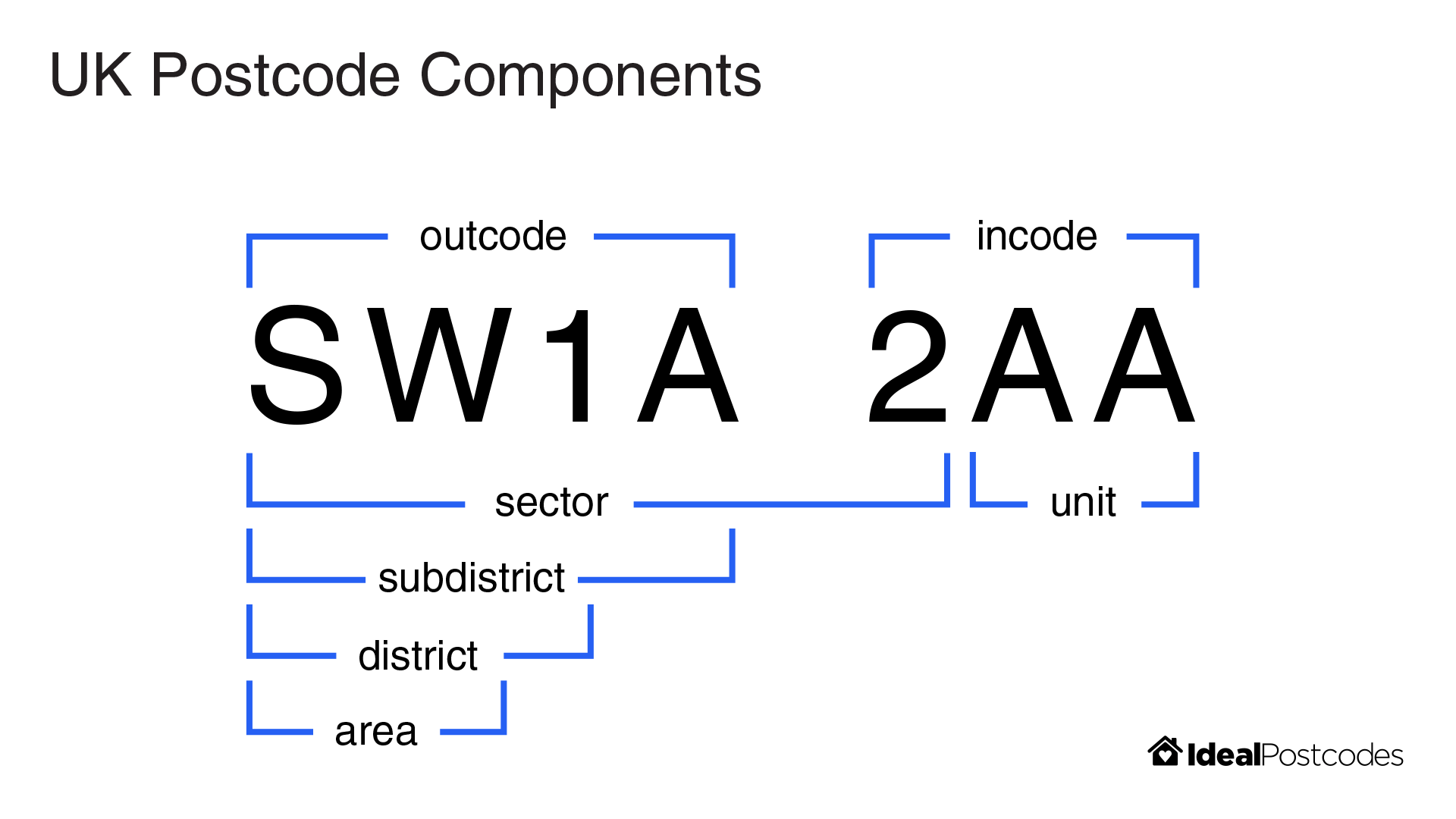
A UK postcode is divided into two distinct parts separated by a single space: the Outward Code and the Inward Code.
- The Outward Code (Outcode): This is the first half of the postcode (e.g., SW1A, M1, EH1). It identifies the postal area and the postal district. It is used by sorting offices to direct mail to the correct regional distribution center.
- Area: The first one or two letters (e.g., “L” for Liverpool, “G” for Glasgow).
- District: The subsequent numbers or letters that narrow the location down to a specific town or part of a city.
- The Inward Code (Incode): This is the second half (e.g., 0AA, 2BT). It is essential for the final stage of delivery.
- Sector: The first digit of the incode, which aids in sorting mail into local delivery beats.
- Unit: The final two letters, which define a group of up to 80 addresses (the “delivery point”).
Data Validation and Formatting
From a technical standpoint, the UK postcode system follows a strict set of rules defined by the British Standard BS 7666. For software developers and database administrators, implementing regex (Regular Expression) patterns to validate these strings is a common task. Because the format can vary in length (from five to seven characters excluding the space), the data validation logic must account for specific positional rules—such as the fact that the letters Q, V, and X are never used in the first position of the outcode.
2. Postcodes in the Digital Economy: APIs and Address Verification
In the realm of e-commerce and fintech, the postcode is the linchpin of the user experience. Whenever a user enters their postcode into a “Find Address” field on a website, they are interacting with a complex web of APIs and databases.
The Postcode Address File (PAF)
The backbone of all UK address-related technology is the Postcode Address File (PAF), maintained by the Royal Mail. This database contains over 30 million delivery points. Tech companies license this data to build Address Verification Systems (AVS). When a developer integrates a service like Postcode Anywhere or Loqate, they are essentially querying a cloud-based version of the PAF.
Integration in Software Development
For modern web applications, the postcode serves as a primary search parameter. Technically, this involves:
- Frontend Capture: A user inputs a string.
- API Call: The application sends a GET request to an address lookup service.
- JSON Response: The service returns an array of addresses associated with that specific unit code.
- Parsing: The software parses the JSON to populate fields for “Street,” “City,” and “County,” reducing friction and preventing “fat-finger” data entry errors.
This automation is not merely a convenience; it is a critical component of digital security and fraud prevention. In fintech, matching a user’s provided address against the registered address of their credit card (via the postcode) is a primary layer of defense in “Card Not Present” (CNP) transactions.
3. Geospatial Intelligence: From Alphanumeric Strings to GPS Coordinates
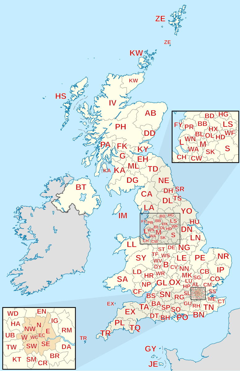
One of the most powerful applications of the UK postcode system is in Geographic Information Systems (GIS). Because UK postcodes are so granular, they can be translated into precise geographic coordinates (latitude and longitude) through a process known as geocoding.
The Concept of the “Centroid”
Every postcode in the UK has a “centroid”—a central point calculated by the Ordnance Survey (the UK’s national mapping agency). In a database, a postcode like “SW1A 1AA” is mapped to an Easting and Northing coordinate.
This technical link allows businesses to perform sophisticated spatial analysis:
- Logistics Optimization: Delivery algorithms use postcode centroids to calculate the “Traveling Salesman Problem,” determining the most efficient route for a fleet of vehicles.
- Catchment Analysis: Retailers use geocoded postcode data from customers to create heat maps, identifying where their audience lives and where to strategically open new physical locations.
- Risk Modeling: For insurance technology (InsurTech), postcodes are used to assess localized risks. An algorithm can query historical data linked to a specific postcode to determine the probability of flooding, subsidence, or theft, instantly adjusting premium prices via automated underwriting engines.
4. Database Management and Data Integrity Challenges
While the postcode system is robust, it is not static. The Royal Mail updates the PAF constantly, adding new postcodes for new housing developments and retiring old ones when buildings are demolished. For data engineers, this presents a significant challenge in maintaining data integrity.
Dealing with “Dirty Data”
In large-scale enterprise databases, address data often becomes “dirty”—inconsistent, outdated, or incorrectly formatted. Maintaining a “Single Source of Truth” requires:
- Data Normalization: Ensuring all postcodes are stored in a consistent format (e.g., all uppercase with a standardized space).
- Periodic Deduplication: Using fuzzy matching algorithms to identify duplicate records that may have slight variations in the address but share the same postcode.
- Real-time Cleansing: Implementing triggers that validate a postcode against a live API whenever a record is updated.
Privacy and the GDPR
From a digital security and legal perspective, a full postcode is often classified as “Personal Data” under the General Data Protection Regulation (GDPR). Because a UK postcode can represent such a small number of households (sometimes just one), it can, when combined with other data points, lead to the identification of an individual. Therefore, technical architectures must ensure that postcode data is encrypted at rest and that access is logged and audited to comply with modern privacy standards.
5. The Future of Addressing: AI, Automation, and Beyond
As we move toward a future of autonomous deliveries and smart cities, the traditional postcode is being augmented by new technologies. While the alphanumeric string remains the standard, the underlying tech is shifting.
Machine Learning in Routing
Modern logistics companies are no longer relying solely on static postcode maps. They are using machine learning models that ingest real-time traffic data, weather patterns, and historical delivery times associated with specific postcodes. This creates “dynamic routing” protocols that can predict delivery windows with minute-by-minute accuracy.
Alternative Addressing Systems
We are also seeing the rise of proprietary digital addressing systems like what3words, which divides the world into 3-meter squares. While some emergency services and delivery apps have integrated these technologies, they function alongside, rather than instead of, the UK postcode. The postcode’s deep integration into the UK’s legal, financial, and governmental software systems ensures its longevity.
The Role of IoT
The Internet of Things (IoT) is further embedding the postcode into the fabric of daily life. Smart home devices and local grid sensors use postcode data to localize software updates, weather alerts, and energy distribution. In this context, the postcode is less about mail and more about “digital localization”—telling a cloud-connected device exactly where it sits within a global network.

Conclusion
The question “what is a UK zip code number” invites a simple answer: it is a postcode. However, the technical reality is far more profound. The UK postcode is a sophisticated alphanumeric protocol that serves as the backbone of the nation’s digital and physical infrastructure. From the regex patterns used by developers to validate input, to the geospatial centroids used by AI to optimize logistics, the postcode is a masterpiece of data organization.
For businesses and technologists, understanding the granular architecture of this system is essential. It is not just an address; it is a data point that facilitates secure commerce, powers complex spatial analytics, and enables the seamless flow of information in an increasingly connected world. As technology continues to evolve, the UK postcode will remain a vital primary key in the database of British life.
aViewFromTheCave is a participant in the Amazon Services LLC Associates Program, an affiliate advertising program designed to provide a means for sites to earn advertising fees by advertising and linking to Amazon.com. Amazon, the Amazon logo, AmazonSupply, and the AmazonSupply logo are trademarks of Amazon.com, Inc. or its affiliates. As an Amazon Associate we earn affiliate commissions from qualifying purchases.