
The Tropics of Cancer and Capricorn, enigmatic lines that encircle our planet, have long captivated human curiosity. More than just abstract geographical markers, they delineate a vibrant, diverse, and crucially important band of Earth, heavily influenced by solar dynamics. While their fundamental definition stems from astronomy and geography, our contemporary understanding, monitoring, and interaction with these tropical zones are profoundly shaped by advancements in technology. From the precision of satellite mapping to the predictive power of AI in climate modeling, technology serves as our indispensable tool for comprehending, managing, and sustaining life within and around these vital latitudes. This article delves into what the Tropics of Cancer and Capricorn represent, fundamentally, and then explores how cutting-edge technology illuminates their significance, addresses their unique challenges, and unlocks their vast potential.
Unpacking the Tropical Lines: A Foundation for Digital Understanding
Before we examine the technological interface, it’s essential to ground ourselves in the basic scientific principles behind the Tropics of Cancer and Capricorn. These lines are not arbitrary but are direct consequences of Earth’s cosmic dance.
The Astronomical Basis: Earth’s Tilt and Solstices
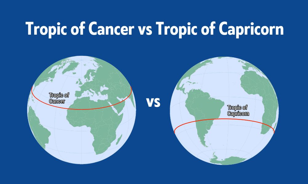
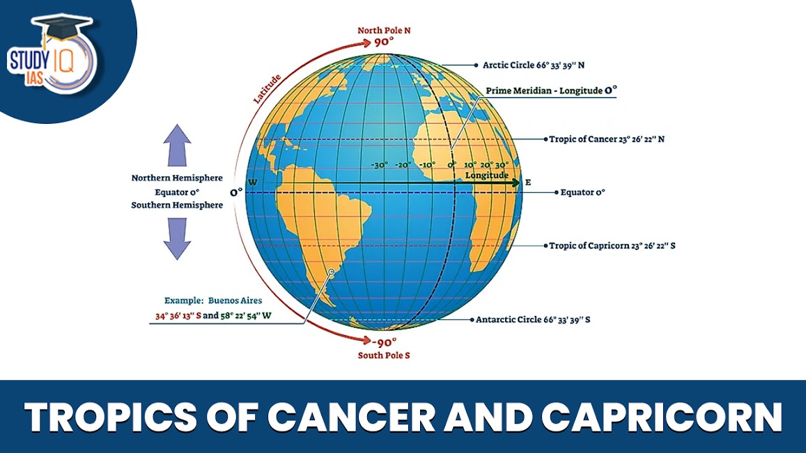
At their core, the Tropics of Cancer and Capricorn are defined by the Earth’s axial tilt. Our planet spins on an axis that is currently tilted at approximately 23.5 degrees relative to its orbital plane around the Sun. This tilt is the primary reason for seasons. The Tropic of Cancer is located at 23.5 degrees North latitude, and the Tropic of Capricorn is at 23.5 degrees South latitude. These specific latitudes mark the northernmost and southernmost points, respectively, where the Sun’s rays can be directly overhead at noon.
For the Tropic of Cancer, this overhead solar position occurs around June 21st, coinciding with the Northern Hemisphere’s summer solstice. On this day, the Sun reaches its highest point in the northern sky, directly illuminating the Tropic of Cancer. Conversely, the Tropic of Capricorn experiences the Sun directly overhead around December 21st, marking the Southern Hemisphere’s summer solstice. These solstices represent the extremes of the Sun’s apparent path across the sky throughout the year, defining the boundaries of the tropical zone where direct overhead sunlight is possible at some point.
Geographical Significance: Climate Zones and Biodiversity
The regions between the Tropics of Cancer and Capricorn constitute the Earth’s tropical zone. This expansive belt covers roughly 40% of the Earth’s land area and is home to nearly half of the world’s population. Geographically, these regions are characterized by consistently warm temperatures and, in many areas, abundant rainfall, supporting some of the planet’s most diverse ecosystems. Rainforests, savannas, coral reefs, and vast deserts all find their home within these tropical boundaries.
The consistent solar input within the tropics drives intense biological activity, leading to unparalleled biodiversity. This zone is a crucible for life, hosting a majority of the world’s plant and animal species. Furthermore, it plays a critical role in global weather patterns, influencing ocean currents, atmospheric circulation, and the formation of major weather systems like hurricanes and monsoons. Understanding these geographical and ecological dynamics is the groundwork upon which technological interventions are built, allowing us to interact with these complex systems more effectively.
Mapping the Tropics: Precision Through Geographic Information Systems (GIS) and GPS
The precise delineation and dynamic monitoring of the Tropics of Cancer and Capricorn, along with the vast territories they encompass, are unimaginable without modern mapping technologies. Geographic Information Systems (GIS) and Global Positioning Systems (GPS) have revolutionized our ability to understand, navigate, and manage these critical regions.
The Evolution of Cartography to Digital Mapping
Historically, mapping the Earth was a laborious process, relying on celestial observations, land surveys, and rudimentary instruments. Early cartographers painstakingly charted coastlines and major landforms, but the precise location of abstract lines like the Tropics of Cancer and Capricorn was an intellectual construct, difficult to pinpoint on the ground with high accuracy. The advent of digital mapping, powered by GIS, has transformed this.
GIS platforms integrate various types of spatial data – satellite imagery, topographical maps, demographic information, climate data, and more – into layered, interactive digital maps. For the tropics, this means we can visualize not just the 23.5-degree latitude lines themselves, but also overlay data on rainforest cover, urban development, agricultural zones, ocean temperatures, and even disease prevalence within these areas. GIS allows for complex spatial analysis, helping researchers identify patterns, predict changes, and inform decision-making concerning land use, conservation efforts, and urban planning across the tropical belt. The ability to model different scenarios digitally is invaluable for proactive management in these rapidly changing regions.
GPS and Satellite Technology: Pinpointing Our Position
Complementing GIS, GPS technology offers real-time positioning with extraordinary accuracy. A network of satellites orbiting Earth constantly transmits signals, which GPS receivers on the ground use to calculate their precise location. This technology is fundamental for navigation within the sprawling and often challenging terrains of the tropics, from guiding ships through intricate coral reefs to aiding explorers in dense rainforests.

Beyond personal navigation, satellite technology is pivotal for monitoring the Tropics of Cancer and Capricorn on a macro scale. Earth observation satellites continuously collect vast amounts of data, providing high-resolution imagery and sensor readings. This data allows scientists to track deforestation rates in the Amazon, monitor the health of the Great Barrier Reef, detect changes in glacier mass on tropical mountains, and observe the migration patterns of tropical wildlife. Furthermore, sophisticated radar and lidar technologies onboard satellites can penetrate cloud cover and vegetation, providing detailed topographical maps and insights into forest structure, which are crucial for understanding biomass and carbon sequestration potential in tropical ecosystems. The sheer volume and granularity of data gathered by these satellite systems are transforming our capacity to observe, analyze, and react to environmental shifts within the tropics.
Beyond Geography: Technological Applications in Tropical Regions
The influence of technology extends far beyond simply mapping and defining the Tropics of Cancer and Capricorn. It plays a crucial role in addressing the unique environmental, social, and economic challenges and opportunities prevalent in these zones.
Climate Modeling and Environmental Monitoring
The tropical zone is at the forefront of climate change impacts, experiencing more frequent and intense extreme weather events, rising sea levels, and shifting precipitation patterns. Advanced technological tools are indispensable for understanding and mitigating these effects. Supercomputers and sophisticated climate models run complex simulations, integrating vast datasets on ocean temperatures, atmospheric pressure, and greenhouse gas concentrations to predict future climate scenarios for the tropical belt. These models help us forecast hurricane trajectories, anticipate monsoon failures or excesses, and project long-term changes in biodiversity.
Furthermore, a network of Internet of Things (IoT) sensors deployed across tropical ecosystems provides real-time environmental monitoring. These sensors can track temperature, humidity, soil moisture, water quality, and even acoustic data to monitor wildlife populations or detect illegal logging activities. Data analytics and artificial intelligence (AI) algorithms process this continuous stream of information, identifying anomalies, alerting authorities to potential threats, and providing scientists with unprecedented insights into the health and resilience of tropical environments. From smart weather stations to underwater sensor networks, these technologies are giving us an early warning system for a region critically vulnerable to environmental shifts.
Sustainable Development and Resource Management Tech
Many nations within the Tropics of Cancer and Capricorn face significant development challenges, including food security, access to clean water, and sustainable energy. Technology offers innovative solutions tailored to these unique contexts. In agriculture, precision farming techniques, enabled by drones and AI, allow farmers to optimize irrigation, fertilizer application, and pest control, boosting yields while minimizing environmental impact. Drones can survey vast tropical plantations, identify crop diseases early, and even aid in targeted spraying, reducing chemical use.
For energy, the abundant solar radiation within the tropics makes solar power a highly viable and scalable solution. Innovations in solar panel efficiency, energy storage, and smart grid technology are making renewable energy more accessible and affordable for remote tropical communities. Beyond energy, digital platforms are being developed to enhance supply chain transparency for tropical commodities like coffee, cocoa, and timber, helping to combat illegal deforestation and ensure fair trade practices. These platforms leverage blockchain and other tracking technologies to provide consumers with verifiable information about the origin and sustainability of products sourced from tropical regions. Technology, therefore, acts as a critical enabler for sustainable economic growth and environmental stewardship in these sensitive areas.
The Future of Tropical Exploration and Data: AI and Advanced Analytics
As technology continues its rapid evolution, the future holds even more profound possibilities for our engagement with the Tropics of Cancer and Capricorn. Artificial intelligence and advanced analytics are poised to unlock deeper insights and create transformative solutions for the region.
Predictive Analytics for Tropical Challenges
AI’s capacity for pattern recognition and predictive modeling is particularly relevant to the complex challenges of the tropics. In public health, AI algorithms can analyze climate data, population movements, and epidemiological records to predict outbreaks of vector-borne diseases like malaria, dengue, and Zika, which are prevalent in tropical climates. This allows for proactive public health interventions, such as targeted mosquito control programs or early deployment of medical resources. Similarly, machine learning can optimize logistics and infrastructure development in challenging tropical terrains, identifying optimal routes for roads or power lines while minimizing environmental disruption. By processing vast datasets on topography, soil composition, and weather patterns, AI can design more resilient and sustainable infrastructure solutions.
Immersive Technologies for Education and Research
Immersive technologies such as Virtual Reality (VR) and Augmented Reality (AR) are set to revolutionize how we experience and study the tropics. VR applications can transport students and researchers into the heart of a rainforest or beneath the surface of a coral reef, offering highly detailed, interactive, and safe explorations of these fragile ecosystems without physical travel. This is invaluable for educational outreach and for training conservationists and scientists. AR tools can overlay digital information onto the real world, assisting field researchers with species identification, data collection, and mapping in remote tropical locations. Furthermore, the concept of “digital twins” – virtual replicas of physical systems – can be applied to tropical ecosystems, allowing scientists to simulate the effects of climate change, pollution, or conservation strategies in a controlled digital environment before implementing them in the real world. This offers a powerful new avenue for research and policy-making.
Conclusion: Tech as the Compass for the Tropics
The Tropics of Cancer and Capricorn, defined by Earth’s tilt and the Sun’s direct rays, represent a global zone of immense ecological significance and human habitation. While their astronomical and geographical definitions remain constant, our ability to understand, navigate, and protect these regions has been fundamentally transformed by technology. From the precise mapping capabilities of GIS and GPS that delineate these crucial latitudes to the advanced climate models and AI-driven predictive analytics that safeguard tropical environments and communities, technology serves as our indispensable compass.
As we face the escalating challenges of climate change, biodiversity loss, and sustainable development within this vital belt, the role of technological innovation will only grow. By leveraging cutting-edge tools in environmental monitoring, sustainable agriculture, renewable energy, and public health, we can foster resilience, promote equitable growth, and ensure the long-term health of the diverse ecosystems and communities that thrive between the Tropics of Cancer and Capricorn. Technology doesn’t just explain what these lines are; it empowers us to shape a more informed and sustainable future for the entire tropical world.
aViewFromTheCave is a participant in the Amazon Services LLC Associates Program, an affiliate advertising program designed to provide a means for sites to earn advertising fees by advertising and linking to Amazon.com. Amazon, the Amazon logo, AmazonSupply, and the AmazonSupply logo are trademarks of Amazon.com, Inc. or its affiliates. As an Amazon Associate we earn affiliate commissions from qualifying purchases.