
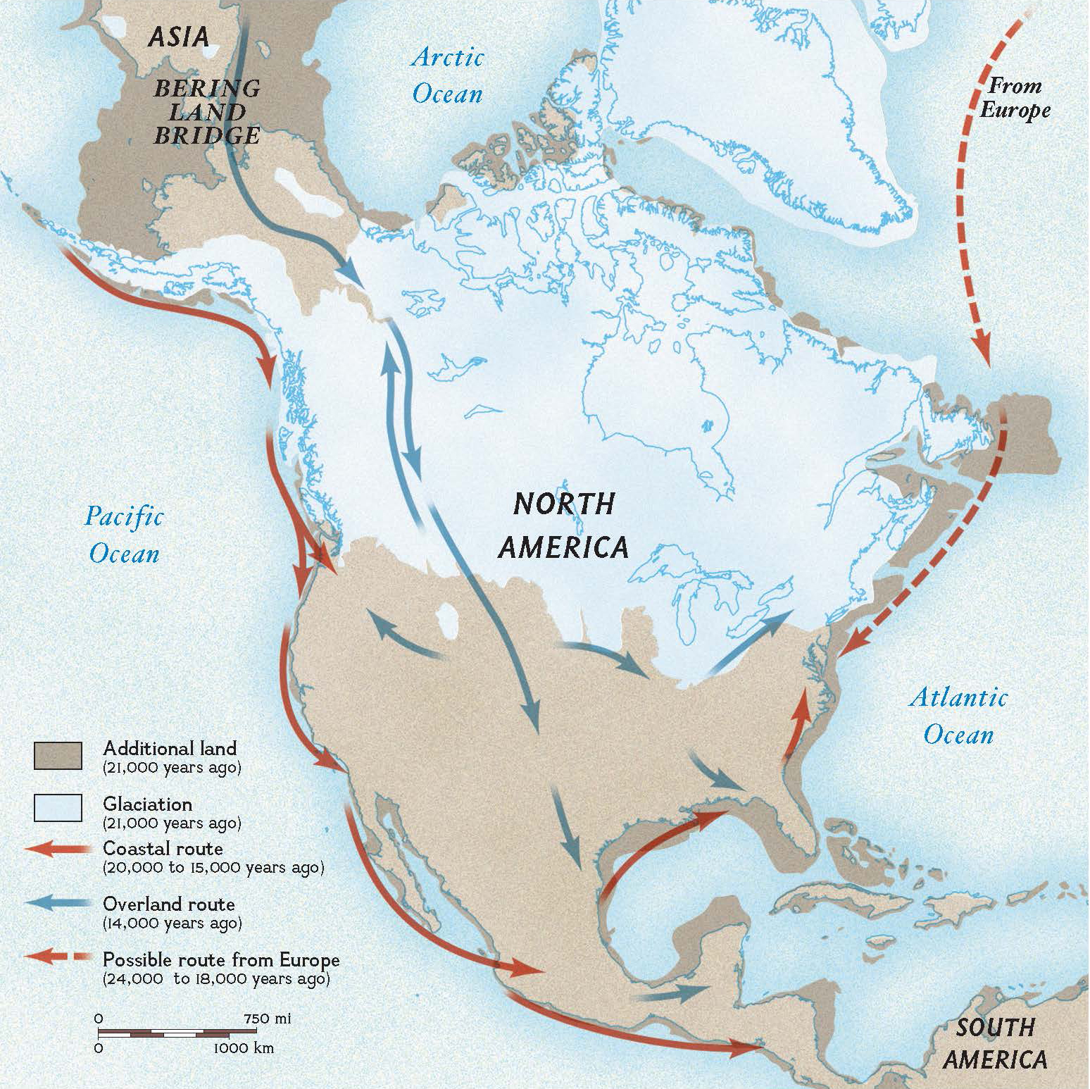
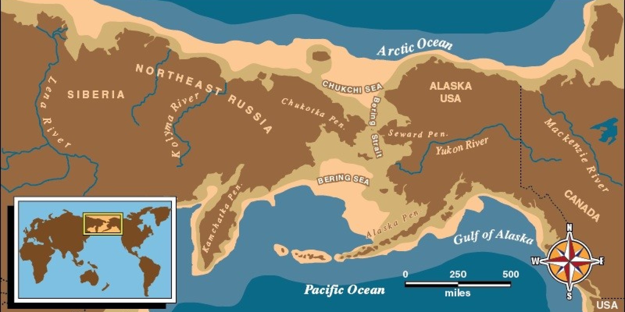
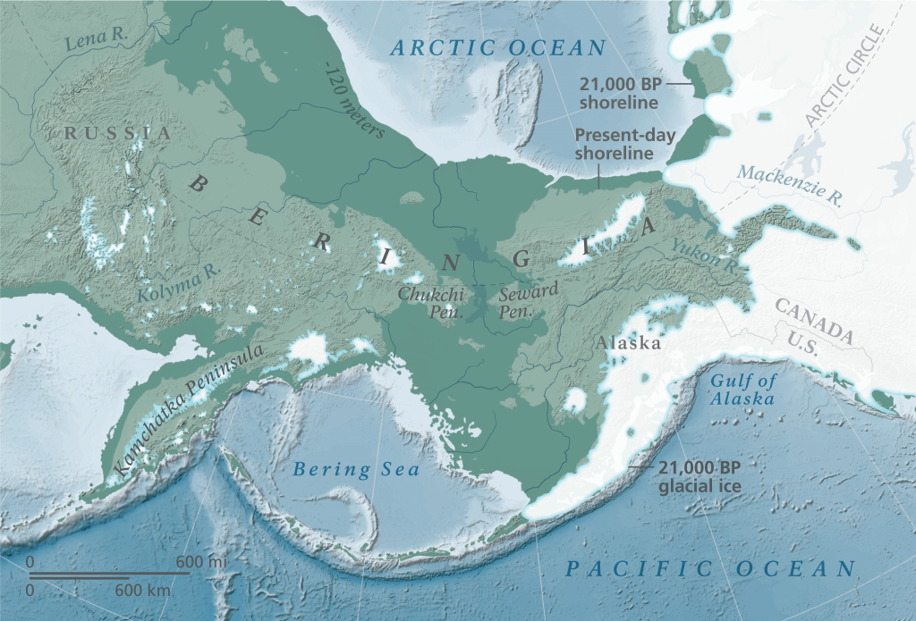
The Land Bridge Theory, most famously exemplified by Beringia, posits that periods of lowered global sea levels, primarily during ice ages, exposed stretches of land that connected continents or major landmasses previously separated by water. These “land bridges” served as vital corridors, facilitating the migration of plants, animals, and, most significantly, early humans, shaping biodiversity and human dispersal across the globe. While the core concept is rooted in geology and anthropology, our modern understanding, verification, and articulation of this profound theory are inextricably linked to cutting-edge technological advancements. From sophisticated geospatial mapping to artificial intelligence-driven data analysis and immersive educational tools, technology has transformed the study of ancient pathways, bridging the gap between historical conjecture and scientific certainty.
Unearthing Ancient Pathways: The Role of Geospatial Technology
The reconstruction of ancient landscapes and the identification of potential land bridge corridors rely heavily on advanced geospatial technologies. These tools allow scientists to peer back through millennia, mapping features that have long since disappeared under modern oceans or ice sheets, providing critical evidence for the Land Bridge Theory.
GIS and Remote Sensing for Paleogeographic Reconstruction
Geographic Information Systems (GIS) stand at the forefront of paleogeographic research. By integrating diverse datasets—including bathymetry (ocean floor topography), sediment cores, geological surveys, and fossil records—GIS platforms create dynamic, layered maps that depict past environments. Researchers can input data points representing ancient coastlines inferred from sea-level markers or glacial extents, then use GIS to interpolate the probable existence and extent of land bridges like Beringia.
Remote sensing technologies further augment this capability. While satellites observe the present Earth, the principles applied to interpret modern landscapes can be extended. For instance, Lidar (Light Detection and Ranging) data, when applied to coastal and submerged areas, can reveal subtle topographical features that might indicate ancient riverbeds or shorelines, later submerged by rising sea levels. High-resolution satellite imagery, coupled with advanced image processing algorithms, can help identify geological signatures of past glacial activity or sediment deposition patterns that corroborate land bridge formation. The visualization capabilities of GIS are also paramount, allowing for the creation of compelling 3D models and animations that illustrate the dynamic nature of these ancient connections over vast timescales.
Computational Models of Climate and Sea Level Dynamics
Understanding when and where land bridges formed is contingent upon accurate estimations of past global sea levels, which are primarily dictated by glacial cycles. This is where powerful computational models come into play. Paleoclimatologists and geophysicists employ complex atmospheric-oceanic general circulation models (AOGCMs) to simulate past climate conditions, including temperature fluctuations, precipitation patterns, and the growth and retreat of massive ice sheets.
These simulations are critical because they directly inform models of global ice volume, which, in turn, predict global average sea levels. By integrating data from ice cores, deep-sea sediments, and geological proxies, supercomputers run scenarios that reconstruct glacial maxima and minima, precisely pinpointing periods when vast amounts of water were locked up in ice, causing sea levels to drop significantly (sometimes over 100 meters below present levels). These computational models not only predict the existence of land bridges but also their timing and duration, offering crucial chronological frameworks for migration events. The accuracy of these models is continuously refined through the input of new geological and climatic data, making them indispensable tools for validating the Land Bridge Theory.
Beyond Maps: AI, Data Science, and Archaeological Discovery
While geospatial tech provides the stage, artificial intelligence (AI) and advanced data science delve into the details of who traversed these land bridges and how. These technologies enable researchers to process vast, complex datasets, uncovering patterns and connections that would be impossible to discern through traditional methods.
AI-Driven Analysis of Archaeological and Genetic Data
AI and machine learning (ML) algorithms are revolutionizing how archaeologists and geneticists interpret evidence related to human migration across land bridges. In archaeology, AI can analyze vast collections of artifacts—such as tools, pottery shards, and remnants of human activity—to identify stylistic similarities, temporal patterns, and geographic distributions. For instance, ML models can be trained on known artifact types to classify new discoveries, map their spread, and even suggest potential migration routes that align with land bridge timings. Predictive analytics, a subset of AI, can also forecast probable settlement patterns or resource exploitation strategies based on environmental conditions and known human behaviors, offering new hypotheses for exploration.
In the realm of genetics, AI processes massive genomic datasets from ancient and modern human populations. Machine learning algorithms can identify genetic markers, track lineage diversification, and estimate divergence times between populations. By analyzing ancient DNA (aDNA) extracted from skeletal remains, AI can pinpoint the origins of specific genetic groups and trace their dispersal paths, often providing compelling corroboration for migrations across land bridges. For example, the genetic commonalities between indigenous populations of the Americas and certain Siberian groups strongly support the Beringian land bridge hypothesis, with AI models refining the timings and specific routes of these early migrations.
Big Data and Interdisciplinary Synthesis
The Land Bridge Theory is inherently interdisciplinary, drawing insights from geology, climatology, oceanography, archaeology, anthropology, and genetics. Integrating and synthesizing this enormous volume of disparate data is a monumental task, made manageable through big data analytics platforms. These platforms are designed to ingest, process, and analyze heterogeneous datasets, allowing researchers to find correlations and construct a coherent narrative from fragmented evidence.
Cloud computing infrastructure provides the scalable storage and computational power required to manage these vast databases. Researchers can upload and share data globally, fostering collaborative research efforts that transcend geographical boundaries. Data visualization tools within these platforms help to present complex findings in an accessible manner, revealing overarching trends and confirming or challenging existing hypotheses. By enabling the seamless integration and cross-referencing of geological evidence of land bridges with archaeological findings of human presence and genetic markers of population movements, big data analytics creates a robust, evidence-based understanding of the Land Bridge Theory that no single discipline could achieve alone.
Immersive Technology: Bridging the Past and Present for Education and Research
Beyond scientific discovery, technology plays a crucial role in making the Land Bridge Theory accessible and understandable to a broader audience, fostering engagement and facilitating advanced research collaboration.
Virtual and Augmented Reality for Experiential Learning
Virtual Reality (VR) and Augmented Reality (AR) technologies offer unprecedented opportunities for experiential learning about ancient landscapes and migrations. Imagine donning a VR headset and being transported back to the height of the last ice age, standing on the vast, treeless steppe of Beringia. Users can “walk across” the exposed land, observe the flora and fauna that once thrived there, and visualize the scale of the ice sheets that covered much of North America. This immersive experience transforms abstract geological and historical concepts into tangible, memorable realities, making the complexities of the Land Bridge Theory accessible to students and the public alike.
AR applications, conversely, can overlay digital reconstructions of land bridges onto real-world maps or geographical features, allowing users to interact with ancient geography in their current environment. These tools are invaluable for educational institutions, museums, and science centers, providing engaging and interactive ways to explore human origins and the dynamic history of our planet. They bring a level of engagement that traditional textbooks or static maps simply cannot achieve, fostering a deeper appreciation for the scientific process and the scale of geological time.
Digital Archiving and Collaborative Platforms
The preservation of research data, archaeological findings, and scientific literature is paramount for the ongoing study and validation of the Land Bridge Theory. Digital archiving, supported by robust cloud storage and distributed database systems, ensures that invaluable data remains secure, accessible, and immutable for future generations of researchers. High-resolution scans of artifacts, 3D models of excavation sites, genomic sequences, and detailed environmental data can all be stored, indexed, and retrieved with ease.
Furthermore, collaborative online platforms leverage these digital archives to create virtual research environments. Scientists from different continents can co-author papers, share preliminary findings, analyze data collectively, and engage in real-time discussions, irrespective of their physical location. Tools like secure file-sharing services, video conferencing, and shared digital workspaces facilitate this global collaboration. These platforms accelerate the pace of discovery, allow for peer review and validation on an unprecedented scale, and ensure that the most current understanding of the Land Bridge Theory is built upon a foundation of shared, verifiable digital evidence, continually refined by a global scientific community.
In conclusion, the Land Bridge Theory is a cornerstone of our understanding of human history and global biodiversity. While its core principles are rooted in geological and anthropological inquiry, it is through the pervasive application of modern technology—from advanced geospatial mapping and computational modeling to AI-driven data analysis and immersive VR experiences—that this ancient narrative truly comes to life. These technological tools not only confirm the theory’s validity but also deepen our insights, foster global collaboration, and make the incredible journey of our ancestors accessible to all, continually pushing the boundaries of what we can learn about our planet’s past.
aViewFromTheCave is a participant in the Amazon Services LLC Associates Program, an affiliate advertising program designed to provide a means for sites to earn advertising fees by advertising and linking to Amazon.com. Amazon, the Amazon logo, AmazonSupply, and the AmazonSupply logo are trademarks of Amazon.com, Inc. or its affiliates. As an Amazon Associate we earn affiliate commissions from qualifying purchases.