
For centuries, the human understanding of our planet’s form has evolved from a flat disc to a perfect sphere. However, as our technological capabilities have advanced into the digital age, we have discovered that the Earth is far more complex than a simple geometric solid. To the modern technologist, data scientist, and engineer, the “real shape of the Earth” is not a static image, but a dynamic, data-driven model known as the Geoid.
Today, the pursuit of defining the Earth’s true shape is driven by cutting-edge technology: from gravity-mapping satellites and LiDAR sensors to complex AI algorithms that process petabytes of geospatial data. Understanding this shape is not merely a matter of scientific curiosity; it is the foundation upon which our global positioning systems, telecommunications, and autonomous transport industries are built.
Satellite Geodesy: The Eyes in the Sky
The most significant leaps in understanding the Earth’s shape have come from our ability to observe the planet from orbit. Satellite geodesy is the branch of technology that uses artificial satellites to measure the Earth’s size, shape, and gravity field with millimeter precision.
The GRACE and GOCE Missions
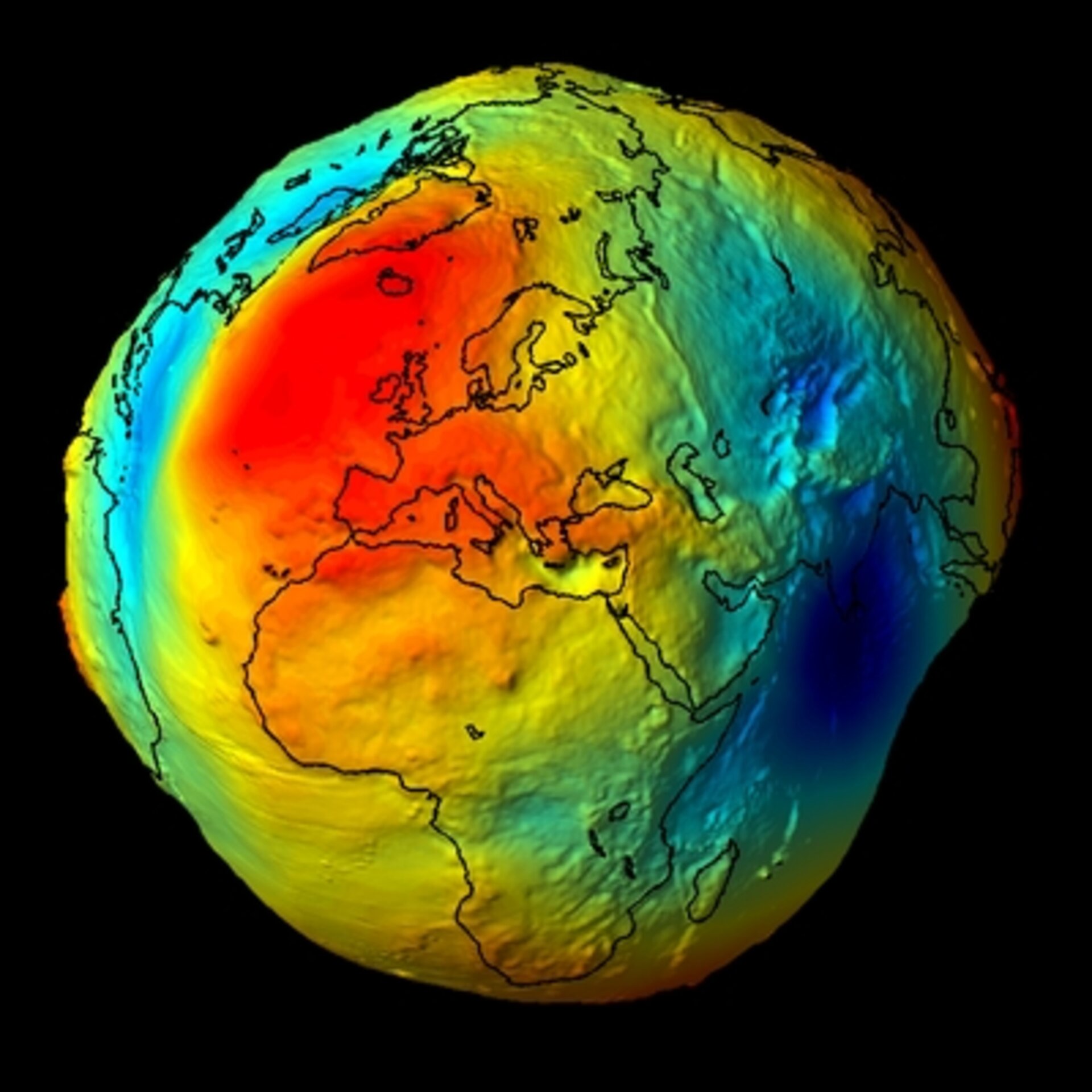
To understand the “real” shape of the Earth, tech professionals look to missions like GRACE (Gravity Recovery and Climate Experiment) and GOCE (Gravity Field and Steady-State Ocean Circulation Explorer). These satellites did not just take photos; they measured the Earth’s gravitational pull. Because the Earth’s mass is not distributed evenly—due to mountains, deep ocean trenches, and varying densities of rock—gravity varies from place to place.
The GOCE satellite, in particular, utilized high-tech gradiometers to sense these tiny variations. The resulting data allowed scientists to create a “Geoid,” a model representing the surface of an ideal global ocean in the absence of tides and currents, shaped only by gravity. This model looks less like a smooth marble and more like a “lumpy potato,” which is the most accurate representation of the planet’s gravitational reality.
GNSS and Precise Positioning Technology
Global Navigation Satellite Systems (GNSS), including GPS, GLONASS, and Galileo, rely entirely on our digital models of the Earth’s shape. For a smartphone to tell you your exact location, it must reference a mathematical model called an ellipsoid (specifically WGS 84).
However, tech advancements in Real-Time Kinematic (RTK) positioning now allow for centimeter-level accuracy by accounting for the discrepancies between the smooth ellipsoid and the irregular Geoid. This layer of technology is what enables precision agriculture, where autonomous tractors plant seeds with surgical precision, and drone delivery systems that require exact altitude data to navigate urban environments safely.
Data Visualization and Digital Twins: Modeling the Oblate Spheroid
Once the raw data is captured by satellites and ground stations, the challenge shifts to the realm of software engineering and data visualization. We no longer rely on paper maps; we use dynamic digital twins—virtual representations of the Earth that update in real-time.
GIS (Geographic Information Systems) in Modern Cartography
Geographic Information Systems (GIS) are the software backbone of modern Earth modeling. Tools like Esri’s ArcGIS and open-source platforms like QGIS allow developers to layer complex datasets over the Earth’s irregular shape. These platforms translate the “oblate spheroid” (the fact that the Earth bulges at the equator due to rotation) into usable digital interfaces.
For tech companies, GIS is vital for infrastructure planning. When laying transoceanic fiber-optic cables or building 5G towers, engineers must account for the Earth’s curvature and its gravitational irregularities to ensure signal integrity and structural stability. The software must calculate the “true” distance over a curved, irregular surface, a task that requires immense computational power.
The Role of LiDAR and Remote Sensing
While satellites provide the macro-view, LiDAR (Light Detection and Ranging) technology provides the micro-view. By mounting LiDAR sensors on aircraft or terrestrial vehicles, we can create high-resolution 3D maps of the Earth’s surface topography.
LiDAR works by firing rapid laser pulses at the ground and measuring the time it takes for them to bounce back. This tech is instrumental in identifying how the Earth’s physical crust deviates from the theoretical models. In the tech sector, this data is integrated into “Digital Elevation Models” (DEMs), which are essential for everything from flood risk AI modeling to the development of high-definition maps for self-driving cars.

AI and Machine Learning: Refining the Geoid
The sheer volume of data generated by modern geodesy is staggering. We are no longer limited by a lack of data, but by the speed at which we can process it. This is where Artificial Intelligence and Machine Learning (ML) have become indispensable tools in determining the Earth’s real shape.
Processing Big Geospatial Data
Machine learning algorithms are now used to “clean” satellite data. Signals from space are often distorted by atmospheric interference, solar flares, or hardware noise. AI models are trained to recognize these patterns and filter them out, leaving behind a much “sharper” image of the Earth’s gravitational and physical contours.
Furthermore, AI helps in merging disparate datasets. For example, it can combine sea-level altimetry from one satellite with land-based gravity measurements from another, creating a seamless global model that was previously impossible to synthesize manually.
Predictive Modeling for Geological Shifts
The Earth’s shape is not static; it is “elastic.” Factors such as post-glacial rebound (where the land rises after the weight of ice sheets is removed) and tectonic plate movements constantly alter the planet’s dimensions.
Advanced ML models are now capable of predictive geomorphology. By analyzing decades of historical data, these AI tools can predict how the Earth’s shape will shift in the coming years. For tech firms invested in long-term infrastructure, such as coastal data centers or satellite ground stations, this predictive tech is essential for mitigating risk associated with the changing shape and sea levels of the planet.
The Practical Tech Applications of an Accurate Earth Model
Why does the “real” shape of the Earth matter to the tech industry? The answer lies in the precision required by our modern digital ecosystem. If our models were off by even a fraction of a percentage, the technologies we take for granted would fail.
Telecommunications and Satellite Orbits
Satellite internet providers, such as Starlink or Kuiper, must maintain precise orbits to provide high-speed coverage. Since the Earth is an oblate spheroid with uneven gravity, a satellite does not orbit in a perfect circle. It “wobbles” as it passes over areas of higher mass (like the Himalayas).
Engineers use high-fidelity gravity models to program the automated station-keeping thrusters on these satellites. Without an accurate understanding of the Earth’s lumpy shape, satellites would eventually drift out of position, leading to signal dropouts and potential orbital collisions.
Autonomous Navigation and Aerospace Engineering
For the aerospace industry, the Earth’s shape dictates the physics of flight. Modern flight management systems (FMS) in commercial aircraft use Geoid height calculations to determine true altitude above mean sea level.
In the emerging sector of Urban Air Mobility (UAM)—such as electric vertical take-off and landing (eVTOL) vehicles—the tech requirements are even more stringent. Navigating through a “smart city” requires a 3D understanding of the environment that accounts for the Earth’s irregular surface. The integration of high-definition Geoid models into the onboard AI of these vehicles is what will make autonomous flight a reality.
The Future of Planetary Measurement
As we look to the future, the technology used to measure our planet will only become more sophisticated. We are moving toward “Geodesy 4.0,” where quantum sensors may replace traditional accelerometers, allowing us to measure gravity with a precision that can detect underground water movements or magma shifts in real-time.
The real shape of the Earth is a testament to the power of human technology. It is a transition from a simple idea to a complex, digital, and ever-changing model. For those in the tech sector, the Earth is not just a planet; it is a massive, complex data set that requires constant monitoring, sophisticated software, and innovative hardware to decode. By mastering the shape of our world, we provide the steady ground upon which the entirety of the digital revolution is built.
aViewFromTheCave is a participant in the Amazon Services LLC Associates Program, an affiliate advertising program designed to provide a means for sites to earn advertising fees by advertising and linking to Amazon.com. Amazon, the Amazon logo, AmazonSupply, and the AmazonSupply logo are trademarks of Amazon.com, Inc. or its affiliates. As an Amazon Associate we earn affiliate commissions from qualifying purchases.