
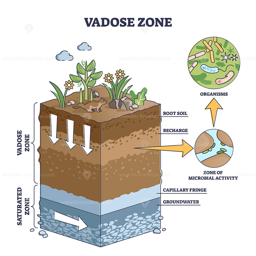
The intersection of earth science and digital innovation has birthed a new era of environmental monitoring, where the most critical insights are no longer found on the surface, but deep within the earth’s “skin.” At the heart of this technological revolution is the vadose zone. Often referred to as the unsaturated zone, the vadose zone is the region of the subsurface that lies between the land surface and the top of the phreatic zone (the water table). While it might sound like a purely geological concern, the vadose zone has become a high-stakes arena for sensor technology, data analytics, and precision engineering.

In the context of modern technology trends, the vadose zone represents a complex data environment. It is the filter through which all surface water must pass before becoming groundwater, and it is the reservoir from which plants draw their lifeblood. For software developers, hardware engineers, and data scientists, understanding and monitoring this zone is essential for solving some of the world’s most pressing challenges, from agricultural efficiency to hazardous waste management.
The Digital Architecture of the Subsurface: Defining the Vadose Zone
To understand why the vadose zone is a burgeoning niche in the tech sector, one must first understand its physical properties through the lens of a systems architect. Unlike the saturated zone below it, where every pore in the soil or rock is filled with water, the vadose zone is a multiphase system. It contains air, water, and solid matter in a constant state of flux.
From Pore Space to Data Points
From a technological perspective, the vadose zone is characterized by “nonlinear dynamics.” The way water moves through this zone is not constant; it depends on the moisture content already present, the tension of the soil particles, and the biological activity within the “rhizosphere” (the root zone). Mapping these variables requires sophisticated sensors capable of measuring soil matric potential and volumetric water content in real-time.
In the past, studying the vadose zone involved manual soil core sampling—a destructive and slow process. Today, we treat the vadose zone as a network of nodes. By deploying IoT (Internet of Things) arrays, engineers can visualize the movement of “wetting fronts” (moisture moving downward) with the same precision that a network admin monitors traffic across a server cluster.
Why Tech is Revolutionizing Unsaturated Zone Monitoring
The shift from geological observation to “Subsurface Tech” is driven by the need for high-resolution data. Traditional models were often based on broad assumptions and regional averages. However, with the rise of edge computing and low-power wide-area networks (LPWAN), we can now collect granular data from deep within the soil profile. This is crucial for “Smart City” infrastructure, where engineers must predict how urban runoff will infiltrate the ground to prevent sinkholes or groundwater contamination.
Next-Generation Sensors: The Hardware Powering Vadose Analytics
The hardware used to monitor the vadose zone has evolved from simple probes to advanced electrochemical and electromagnetic instruments. This hardware must be rugged enough to survive acidic soil conditions and high pressure while remaining sensitive enough to detect minute changes in humidity and chemical composition.
IoT-Enabled Tensiometers and Dielectric Sensors
The gold standard in vadose zone hardware includes Time Domain Reflectometry (TDR) and Frequency Domain Reflectometry (FDR) sensors. These devices measure the dielectric constant of the soil, which is a direct proxy for moisture content.
Modern iterations of these sensors are now fully integrated with IoT stacks. Instead of a technician visiting a field to download data via a serial port, these sensors use LoRaWAN or NB-IoT protocols to transmit data directly to the cloud. This allows for the creation of digital twins—virtual models of the subsurface that update in real-time. For a tech-driven agricultural enterprise, this means being able to trigger automated irrigation systems the moment the vadose zone’s moisture level drops below a specific programmed threshold.
Remote Sensing and Geophysical Imaging Tech
Beyond in-situ sensors, the tech industry is leveraging remote sensing to understand the vadose zone on a macro scale. Satellite-based Synthetic Aperture Radar (SAR) and Thermal Infrared (TIR) imaging provide data on soil moisture that can be integrated with ground-level sensor arrays.
Furthermore, Electrical Resistivity Tomography (ERT) is being used as a “medical imaging” tool for the earth. By passing electrical currents through the ground, tech firms can create 3D maps of the vadose zone’s structure without ever digging a hole. This non-invasive technology is essential for monitoring the integrity of “tailings dams” in mining operations or detecting leaks in underground storage tanks before they reach the water table.
Software and Modeling: Turning Hydrogeological Data into Actionable Insight

Hardware provides the raw data, but it is the software layer that provides the “intelligence.” The vadose zone is notoriously difficult to model because it involves the Richards Equation—a complex partial differential equation that describes water movement in unsaturated soils.
Predictive Analytics for Agricultural Optimization
In the Agritech sector, software platforms are now incorporating “Vadose Zone Modeling” as a core feature. By processing data on soil type, crop stage, and weather forecasts, these AI-driven platforms can predict how a specific volume of water will behave once it enters the soil.
This isn’t just about watering plants; it’s about nutrient management. Nitrogen and other fertilizers move through the vadose zone at different rates. Advanced software tools allow farmers to time their applications so that the nutrients remain in the root zone (the upper vadose zone) rather than leaching into the groundwater. This “Precision Fertigation” is a prime example of how subsurface tech contributes to both profitability and environmental sustainability.
AI and Machine Learning in Groundwater Recharge Models
As climate change disrupts traditional rainfall patterns, many regions are turning to Managed Aquifer Recharge (MAR). This process involves intentionally infiltrating water into the vadose zone to replenish aquifers.
Machine learning algorithms are now used to optimize this process. By analyzing historical data on infiltration rates and soil saturation, AI can determine the optimal “loading rate” for a recharge basin. If water is added too quickly, the vadose zone becomes clogged with fine sediments; if added too slowly, the process is inefficient. Tech firms specializing in environmental AI are developing “autonomous recharge controllers” that adjust water flow based on real-time feedback from subsurface sensors.
The Intersection of Digital Security and Environmental Infrastructure
As we digitize the vadose zone, we also open it up to the risks inherent in any connected system. Environmental monitoring networks are part of our critical infrastructure, and as such, they are becoming targets for cyber-attacks.
Protecting Hydrological Data Networks
The integrity of vadose zone data is paramount. If a bad actor were to spoof the data coming from an industrial site’s monitoring wells, they could hide a toxic leak for months. This has led to an increased focus on digital security within the environmental tech space.
Encrypted data transmission and secure boot protocols for IoT devices are now standard requirements for environmental sensors. Furthermore, firms are looking at “Air-Gapped” data storage for sensitive hydrological records, ensuring that even if a corporate network is compromised, the environmental safety data remains untampered.
Blockchain for Water Right Transparency
In many parts of the world, water is a traded commodity. The movement of water through the vadose zone and into an aquifer determines a landowner’s “water wealth.” Some fintech and environmental tech hybrids are exploring the use of blockchain to track these water movements.
By logging sensor data from the vadose zone onto a decentralized ledger, stakeholders can have an immutable record of how much water was naturally recharged versus how much was extracted. This level of transparency is essential for the future of water markets and the equitable distribution of resources in arid regions.
Future Trends: The Evolution of Subsurface Technology
The next decade will see even deeper integration between the physical vadose zone and the digital world. We are moving toward a “Transparent Earth” where the subsurface is no longer a “black box” but a well-mapped and monitored component of the global ecosystem.
Autonomous Monitoring Systems
We are currently seeing the development of “Subsurface Drones”—small, autonomous robotic probes that can navigate the pore spaces or fractures within the vadose zone. While still in the experimental phase, these micro-bots could revolutionize how we map contamination plumes. Instead of waiting for a plume to reach a static sensor, these autonomous units could seek out the source of a leak in real-time.
The Role of Big Data in Global Water Scarcity Solutions
Ultimately, the data harvested from the vadose zone will feed into global climate models. As we aggregate billions of data points from sensors across the globe, our ability to predict droughts and floods will improve exponentially.
The “vadose zone” may be a term from geology, but its future belongs to the tech sector. From the silicon chips in soil moisture probes to the cloud-based AI that predicts groundwater flow, technology is the key to unlocking the secrets of the unsaturated zone. As we continue to innovate, the vadose zone will serve as the ultimate proving ground for the power of digital transformation to protect and manage our most vital natural resources.
aViewFromTheCave is a participant in the Amazon Services LLC Associates Program, an affiliate advertising program designed to provide a means for sites to earn advertising fees by advertising and linking to Amazon.com. Amazon, the Amazon logo, AmazonSupply, and the AmazonSupply logo are trademarks of Amazon.com, Inc. or its affiliates. As an Amazon Associate we earn affiliate commissions from qualifying purchases.