Mantle convection is a fundamental geodynamic process, an immense engine operating beneath our feet that drives plate tectonics, shapes continents, and influences the very surface features of Earth. While its essence lies in the slow, churning movement of silicate rock within the planet’s mantle, our contemporary understanding of this profound phenomenon is almost entirely a product of advanced technological innovation. From sophisticated sensory equipment to cutting-edge computational models, technology provides the critical tools to peer into the inaccessible depths of our planet, transforming abstract theories into quantifiable data and dynamic simulations.
Unveiling Earth’s Engine Through Advanced Technology
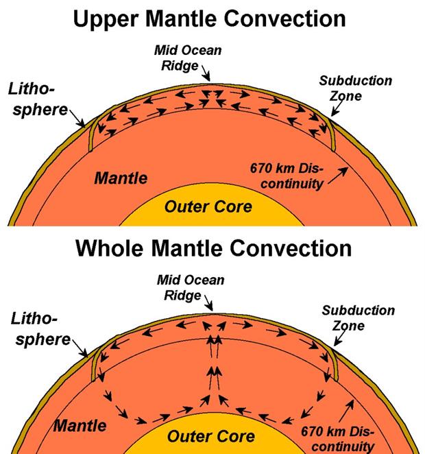
The Earth’s mantle, extending from roughly 30 km to 2,900 km deep, is a high-pressure, high-temperature realm. Direct observation is impossible, necessitating ingenious technological approaches to infer its structure and behavior. These methods leverage diverse physical principles, translating geophysical signals into interpretable data sets that reveal the intricacies of convection.

Seismic Tomography: Peering into the Depths
One of the most powerful technological advancements in understanding mantle convection comes from seismic tomography. This technique, analogous to medical CT scans, uses seismic waves generated by earthquakes or controlled sources to create three-dimensional images of Earth’s interior. Networks of highly sensitive seismographs, acting as advanced sensors, are deployed globally—on land and increasingly on ocean floors—to record the travel times and amplitudes of these waves.
The underlying principle relies on the fact that seismic waves travel at different speeds through materials of varying temperature, composition, and phase. Hotter, less dense rock, characteristic of upwelling mantle plumes or convection cells, tends to slow down seismic waves, while colder, denser material, such as subducting slabs, speeds them up. Sophisticated software algorithms then invert these vast datasets of seismic wave travel times, alongside wave attenuation and anisotropy, to construct detailed maps of seismic velocity anomalies throughout the mantle. These maps reveal the architecture of mantle convection, illustrating regions of fast (cold, sinking) and slow (hot, rising) material, thereby outlining the circulatory patterns of heat and mass. The precision and resolution of these models are constantly improving, thanks to denser sensor networks, higher computational power, and refined inversion techniques, allowing geophysicists to track the fate of subducting plates and identify the roots of volcanic hotspots.
Satellite Geodesy: Measuring Surface Manifestations
While seismic tomography provides a subsurface view, satellite geodesy offers a complementary perspective by measuring the subtle surface expressions of deep mantle processes. These advanced satellite-based systems operate as remote sensors, detecting minuscule changes in Earth’s gravitational field, crustal deformation, and surface topography.
Global Positioning System (GPS) networks, for instance, precisely measure plate tectonic movements, which are the direct surface manifestation of mantle convection. By tracking the motion of millions of receivers worldwide, GPS data reveal how continents drift and deform, providing critical input for models of mantle flow. Interferometric Synthetic Aperture Radar (InSAR) uses radar signals from orbiting satellites to detect minute changes in ground elevation over broad areas, capable of identifying volcanic uplift or subsidence related to magmatic activity driven by mantle plumes. Furthermore, missions like GRACE (Gravity Recovery and Climate Experiment) and GRACE-FO measure variations in Earth’s gravitational field. These data, processed by specialized software, can reveal mass redistributions within the Earth, including large-scale changes in mantle density associated with convection patterns, or even the subtle post-glacial rebound linked to past mantle viscoelastic response to ice sheet removal. These technological capabilities provide crucial constraints on the viscosity and dynamics of the mantle, bridging the gap between deep Earth processes and observable surface phenomena.
Computational Geodynamics: Simulating the Unseen
Understanding the complex physics of mantle convection requires more than just observation; it demands advanced simulation. The mantle behaves as an extremely viscous fluid over geological timescales, but with non-Newtonian properties, phase transitions, and chemical heterogeneities, all operating under immense pressures and temperatures. Modeling such a system is a grand challenge in computational science.

Supercomputing and Fluid Dynamics Models
Supercomputing power is absolutely indispensable for simulating mantle convection. Researchers utilize highly specialized software, often based on finite element, finite difference, or spectral element methods, to numerically solve the complex equations of fluid dynamics (Navier-Stokes equations), heat transfer, and continuum mechanics. These models incorporate thermodynamic parameters, rheological laws describing the mantle’s deformation, and boundary conditions (e.g., heat flux from the core, cooling at the surface).
Supercomputers allow geodynamicists to run simulations over millions to billions of years of geological time, capturing the slow evolution of convection patterns. These computational experiments help test hypotheses about key parameters, such as the mantle’s viscosity structure, the mechanisms of plume generation, the fate of subducted slabs, and the interaction between the core and the mantle. The outputs of these simulations, visualized through sophisticated rendering software, generate dynamic 3D representations of mantle flow, temperature anomalies, and chemical mixing, offering insights into processes that are otherwise inaccessible to direct human perception. They are essential tools for predicting how Earth’s interior might evolve and how its dynamics influence surface geology over geological eras.
AI and Machine Learning in Geophysical Data Interpretation
The sheer volume and complexity of data generated by global sensor networks and supercomputer simulations have outpaced traditional analytical methods. This is where AI tools and machine learning (ML) algorithms are rapidly becoming indispensable. These advanced software techniques are transforming how geoscientists interpret and extract meaningful insights from vast geophysical datasets.
In seismic analysis, machine learning algorithms can rapidly identify and classify earthquake events, distinguish between different types of seismic waves, and automatically detect subtle patterns in noise that might indicate deeper structures. Neural networks are being trained on large seismic tomography datasets to improve the resolution and accuracy of mantle images, speeding up the inversion process and enhancing the detection of mantle plumes or subducted slabs. Furthermore, ML models are proving effective in anomaly detection, identifying unusual seismic signatures that could point to previously unrecognized mantle structures or dynamic processes. Beyond seismic data, AI is applied to satellite geodesy data to refine deformation models and to extract signals related to mantle processes from noisy measurements. By automating pattern recognition, optimizing computational workflows, and uncovering hidden correlations within multi-parameter datasets, AI tools are accelerating discovery and refining our understanding of mantle convection’s intricate mechanisms.
Emerging Technologies and Future Research Directions
The continuous evolution of technology promises even deeper insights into mantle convection. Future research will increasingly rely on a new generation of sensors and more integrated, intelligent modeling platforms.
Next-Generation Sensors and Data Acquisition
Advancements in sensor technology are pushing the boundaries of what can be observed. Ocean bottom seismometers (OBS) are becoming more widespread and sophisticated, extending seismic coverage into vast oceanic regions where critical mantle processes like subduction initiation and mid-ocean ridge dynamics occur. Distributed Acoustic Sensing (DAS), which transforms standard fiber optic cables into dense arrays of seismic sensors, offers unprecedented spatial resolution for seismic imaging near coastlines and even within boreholes. New satellite missions are continually improving temporal and spatial resolution for geodetic measurements, providing finer details on surface deformation and gravity changes. These next-generation gadgets and data acquisition techniques will provide richer, denser, and more continuous datasets, offering an even clearer picture of the mantle’s dynamic state.
Integrated Modeling Platforms
The future of understanding mantle convection lies in the integration of diverse data types and computational models. Researchers are developing sophisticated software platforms that can simultaneously assimilate seismic, geodetic, geochemical, and mineral physics data into unified geodynamic models. These integrated platforms aim to create a holistic, four-dimensional (3D spatial + time) representation of the Earth’s interior. This involves complex data management and security considerations to handle vast, multi-source datasets, ensuring data integrity and accessibility for global collaborative efforts. Furthermore, the incorporation of advanced AI tools into these integrated platforms will facilitate real-time data analysis, predictive modeling of geological events driven by mantle dynamics, and even autonomous model refinement based on new observations. This convergence of sensing technology, supercomputing, and artificial intelligence is paving the way for a comprehensive and dynamic understanding of the Earth’s engine, fundamentally redefining “what is a mantle convection” in the context of our technologically enhanced planetary awareness.
aViewFromTheCave is a participant in the Amazon Services LLC Associates Program, an affiliate advertising program designed to provide a means for sites to earn advertising fees by advertising and linking to Amazon.com. Amazon, the Amazon logo, AmazonSupply, and the AmazonSupply logo are trademarks of Amazon.com, Inc. or its affiliates. As an Amazon Associate we earn affiliate commissions from qualifying purchases.