The intricate dance of our planet’s atmosphere, dictating everything from our daily commutes to agricultural yields and the trajectory of global commerce, is a phenomenon meticulously observed and understood through a diverse array of technological instruments. In the realm of “Tech,” understanding these instruments is not merely an academic pursuit; it’s fundamental to appreciating the sophisticated systems that underpin our modern lives. From the ubiquitous smartphone apps that inform our personal decisions to the massive supercomputers that model future climate scenarios, technology is inextricably linked to weather data acquisition. This article delves into the technological marvels that allow us to peer into the atmosphere, providing insights into current conditions and predicting future patterns.
Ground-Based Observation Networks: The Foundation of Weather Intelligence
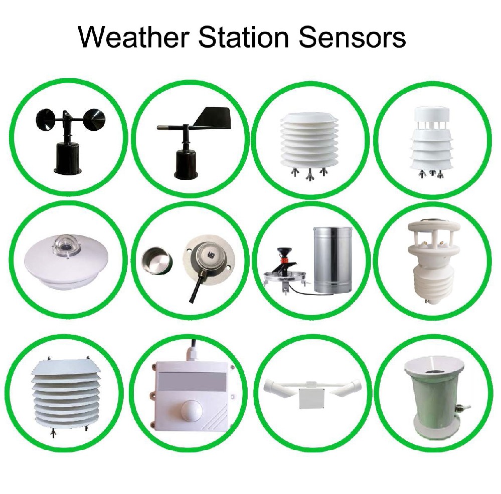
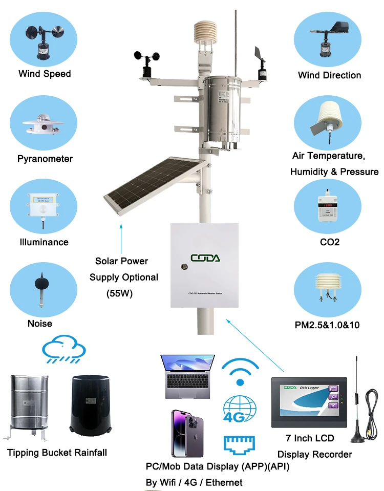
The most immediate and pervasive method of gathering weather information relies on a vast network of ground-based instruments. These are the silent sentinels, constantly measuring and transmitting vital data that forms the bedrock of meteorological understanding. The sheer density and diversity of these instruments ensure comprehensive coverage, even in remote or challenging environments.
Thermometers and Hygrometers: The Basics of Atmospheric State
At the most fundamental level, understanding weather requires knowing its current state. Thermometers measure air temperature, a critical factor influencing everything from cloud formation to the likelihood of precipitation. Different types of thermometers exist, from simple mercury-in-glass devices to highly accurate digital sensors, but their core function remains the same: quantifying thermal energy in the atmosphere.
Complementing temperature readings are hygrometers, which measure the amount of water vapor in the air, or humidity. High humidity levels are crucial for cloud and fog development, and understanding relative humidity is essential for predicting precipitation and assessing potential for heatstroke or dehydration. Advanced hygrometers often utilize capacitive or resistive sensing technologies, providing precise and continuous measurements.
Barometers: The Pulse of Atmospheric Pressure
Atmospheric pressure is a key indicator of weather systems. High-pressure systems are typically associated with fair weather, while low-pressure systems often bring storms and unsettled conditions. Barometers measure this pressure. Aneroid barometers, which use a sealed, flexible metal box that expands or contracts with changes in pressure, are common in domestic settings and for general forecasting. For more precise meteorological applications, mercury barometers were historically used, and modern digital barometers, often incorporating microelectromechanical systems (MEMS) technology, offer exceptional accuracy and stability. The ability to track pressure changes over time allows meteorologists to identify the movement and intensity of weather fronts.
Anemometers and Wind Vanes: Capturing the Air’s Motion
Wind is a powerful force that shapes weather patterns and poses significant risks. Anemometers are designed to measure wind speed, with the most common type being the cup anemometer, where rotating cups catch the wind, and the rotation speed directly correlates to wind velocity. Other technologies include ultrasonic anemometers, which use sound waves to determine wind speed and direction without moving parts, offering greater durability and accuracy in extreme conditions.
Wind vanes, on the other hand, indicate wind direction. These are typically feather-shaped or arrow-shaped devices mounted on a pivot, allowing them to align with the prevailing wind. By combining wind speed and direction data, meteorologists can understand the movement of air masses and predict how weather systems will evolve.
Precipitation Gauges: Quantifying Rainfall and Snowfall
Accurate measurement of precipitation is vital for agriculture, water resource management, and flood prediction. Precipitation gauges, or rain gauges, collect and measure the amount of rainfall over a specific period. Simple cylinder-shaped gauges are common, but more sophisticated tipping-bucket rain gauges automatically record measurements as they fill and empty. For snowfall, specialized gauges are used to measure the depth and water equivalent of snow, often requiring heating elements to melt snow before it can be measured. Advanced radar systems also play a crucial role in estimating precipitation over large areas.
Remote Sensing Technologies: Expanding Our Atmospheric View
While ground-based instruments provide invaluable localized data, remote sensing technologies offer a broader, more comprehensive perspective of the atmosphere. These instruments, often deployed on aircraft, satellites, or balloons, can gather information from vast distances and at various altitudes, revealing patterns and phenomena that would otherwise go unnoticed.
Weather Balloons and Radiosondes: Probing the Upper Atmosphere
Weather balloons, equipped with radiosondes, are crucial for understanding the vertical structure of the atmosphere. A radiosonde is an electronic instrument that measures various atmospheric parameters, including temperature, humidity, pressure, and wind speed and direction, as it ascends into the upper atmosphere. These balloons can reach altitudes of over 30 kilometers, providing data that is critical for numerical weather prediction models. The data is transmitted wirelessly back to ground stations in real-time. The development of advanced materials for balloons and more sensitive sensor technology has significantly improved the accuracy and reach of these atmospheric soundings.
Radar Systems: Visualizing Precipitation and Wind

Radar, short for Radio Detection and Ranging, is a cornerstone of modern weather forecasting. Doppler radar, in particular, can detect not only the presence and intensity of precipitation (rain, snow, hail) but also its movement and velocity. By analyzing the Doppler shift of the reflected radio waves, meteorologists can determine whether precipitation is moving towards or away from the radar and at what speed. This capability is essential for tracking storms, predicting their intensity, and issuing timely warnings for severe weather events like thunderstorms and tornadoes. Advanced radar networks, such as the NEXRAD system in the United States, provide a continuous stream of high-resolution data across vast regions.
Satellites: A Global Vantage Point
Weather satellites are arguably the most powerful tools for gathering global atmospheric information. These artificial celestial bodies orbit the Earth, equipped with a suite of sensors that capture a wide range of data.
Visible and Infrared Imaging: Seeing Clouds and Temperatures
Visible light imagers on satellites capture photographs of the Earth’s surface and cloud cover, similar to how our eyes perceive the world. These images are invaluable for tracking the movement of weather systems and identifying cloud types. Infrared imagers, however, can “see” heat. By measuring the infrared radiation emitted by the Earth’s surface and clouds, these instruments can determine cloud-top temperatures. Colder cloud tops, for instance, often indicate higher altitudes and potentially more intense storm systems. This data is critical for understanding atmospheric circulation and identifying areas of instability.
Microwave Sensors: Penetrating Clouds for Data
While visible and infrared light can be obscured by thick cloud cover, microwave sensors can penetrate clouds to gather information about atmospheric moisture content, sea surface temperatures, and even the structure of storms. These sensors are particularly useful for observing tropical cyclones and other weather phenomena in regions where persistent cloudiness is common.
Sounders: Vertical Profiles of the Atmosphere
Satellite-based sounders are designed to measure atmospheric properties at different altitudes, essentially creating vertical profiles of temperature, humidity, and atmospheric gases. These instruments work by analyzing specific wavelengths of electromagnetic radiation that are absorbed or emitted by different atmospheric constituents. The data from sounders complements the information gathered by radiosondes, providing a more complete picture of atmospheric conditions across the globe.
Advanced Sensing and Data Integration: The Future of Weather Intelligence
The evolution of weather data gathering is not solely about individual instruments but also about how these instruments are integrated and how new technologies are enhancing our capabilities. The digital revolution has transformed meteorology, enabling unprecedented levels of data processing, analysis, and dissemination.
Citizen Science and Crowd-Sourced Data: Empowering the Public
In recent years, the concept of citizen science has gained significant traction in meteorology. Personal weather stations (PWS), connected to the internet, allow individuals to contribute their local weather data to public networks. These PWS can measure temperature, humidity, barometric pressure, wind speed and direction, and precipitation. While individual PWS may not have the same accuracy as professional meteorological equipment, the sheer volume of data from thousands of contributors can provide valuable hyper-local insights and help fill gaps in traditional observation networks. Smartphone apps that leverage crowd-sourced data, such as reporting precipitation intensity or visible fog, are also becoming increasingly prevalent.
The Role of AI and Machine Learning in Data Analysis
The sheer volume of data generated by the global network of weather instruments is immense. Extracting meaningful insights from this data requires sophisticated analytical tools. Artificial intelligence (AI) and machine learning (ML) are playing an increasingly vital role in weather forecasting. AI algorithms can sift through massive datasets to identify complex patterns and relationships that might be missed by human analysts. They are used for tasks such as:
- Improving Data Quality: Identifying and correcting erroneous data from individual instruments.
- Pattern Recognition: Detecting subtle precursors to severe weather events.
- Model Enhancement: Assimilating diverse data sources into numerical weather prediction models with greater efficiency.
- Nowcasting: Providing highly localized, short-term forecasts by rapidly processing real-time sensor data.
The integration of AI and ML with data from advanced instruments is pushing the boundaries of predictive accuracy, allowing for more timely and precise warnings and a deeper understanding of atmospheric dynamics.
The Internet of Things (IoT) and Interconnected Weather Networks
The proliferation of Internet of Things (IoT) devices is further revolutionizing weather data collection. Beyond personal weather stations, IoT is enabling the development of interconnected weather sensing networks in various sectors. Smart cities can deploy sensors on traffic lights and public infrastructure to monitor microclimates. Agriculture can utilize soil moisture sensors, temperature probes, and weather stations to optimize irrigation and crop management. Transportation networks can integrate real-time weather data from sensors along roads and railways to improve safety and efficiency. This interconnectedness allows for a dynamic and responsive approach to weather monitoring, where data from different sources can be combined and analyzed in real-time to provide a holistic view of atmospheric conditions and their impact.
In conclusion, the instruments used to gather information about weather represent a remarkable fusion of engineering, physics, and computer science. From the fundamental measurements taken by ground-based sensors to the expansive reach of satellite-based remote sensing and the analytical power of AI, technology continuously evolves to provide us with a clearer and more predictive understanding of our planet’s atmosphere. This technological tapestry not only informs our daily lives but also underpins critical global efforts in disaster preparedness, climate change mitigation, and sustainable resource management.
aViewFromTheCave is a participant in the Amazon Services LLC Associates Program, an affiliate advertising program designed to provide a means for sites to earn advertising fees by advertising and linking to Amazon.com. Amazon, the Amazon logo, AmazonSupply, and the AmazonSupply logo are trademarks of Amazon.com, Inc. or its affiliates. As an Amazon Associate we earn affiliate commissions from qualifying purchases.