
For decades, the interior of a tornado was the ultimate “black box” of meteorology—a place where physics reached its most violent extremes and where human observation was functionally impossible. To see inside a vortex was to witness the raw engine of atmospheric destruction, yet the opacity of debris and the lethality of the environment kept the truth hidden. Today, the question of what it looks like inside a tornado is no longer being answered by brave eyewitnesses, but by a sophisticated suite of technology ranging from hardened IoT sensors to dual-polarization radar and AI-driven fluid dynamics simulations.
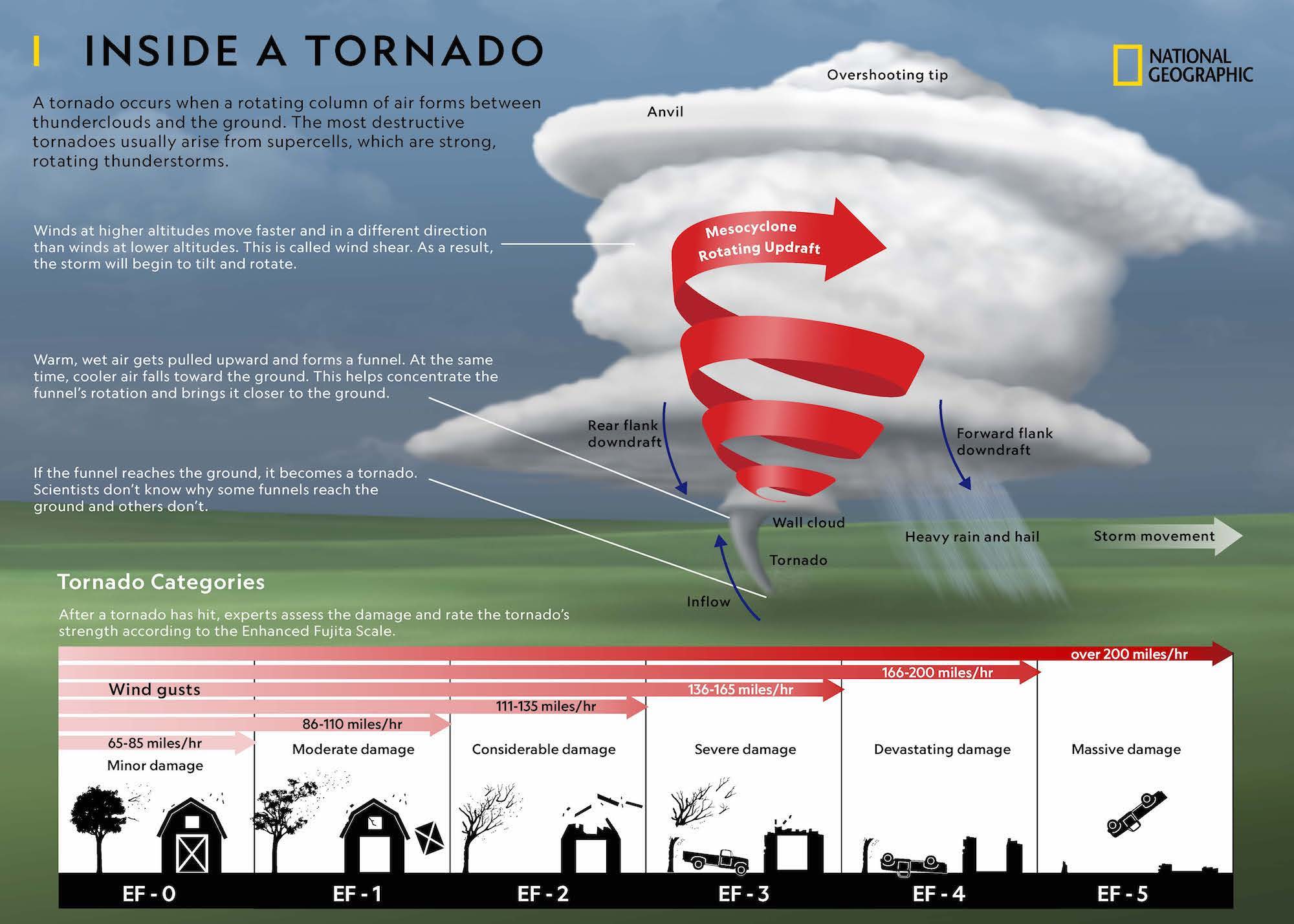
Mapping the interior of a tornado represents one of the most significant challenges in modern tech-driven science. It requires hardware that can withstand supersonic debris and software capable of processing chaotic, high-velocity data points in real-time. By leveraging cutting-edge advancements in remote sensing and digital modeling, we are finally moving past the myths to see the digital skeleton of the world’s most powerful storms.
The Digital Eye: Deploying Advanced Sensor Arrays and IoT
The first step in “seeing” inside a tornado involves placing physical hardware directly in the path of the storm. This is the domain of in-situ sensing—a field that has evolved from basic weighted pods to highly networked, “smart” devices that act as the digital eyes and ears of researchers.
In-Situ Probes and the Evolution of Hardened Hardware
The conceptual ancestor of modern tornado probes was the “TOtable Tornado Observatory” (TOTO), but today’s technology is vastly more advanced. Modern probes are aerodynamic, low-profile discs equipped with high-speed cameras, barometers, and hygrometers. These devices must solve a primary engineering hurdle: staying grounded in 200+ mph winds.
Current tech utilizes “turtling” designs—heavy, lead-weighted shells with spiked anchors. Inside these shells, high-definition cameras are protected by sapphire glass, capable of recording at high frame rates to capture the rapid movement of debris. When a tornado passes over these probes, the data captured reveals a surprising “calm” at the very center—a localized pressure drop so extreme it can cause structural failure in buildings before the wind even hits.
Smart Sensors and Mesh Networking
The newest frontier in this niche is the deployment of “swarm” sensors. Instead of one large probe, researchers are experimenting with hundreds of micro-sensors deployed via drone or air-cannon. These sensors utilize mesh networking to communicate with one another as they are lofted into the vortex.
By treating the tornado as a distributed network of data points, scientists can track the three-dimensional flow of the wind. These IoT (Internet of Things) devices transmit data via hardened radio frequencies to a command vehicle several miles away. This allows for a real-time digital reconstruction of the tornado’s “inflow” and “outflow” jets, providing a look at the thermodynamic engine driving the storm from the inside out.
Visualizing the Vortex: Remote Sensing and Lidar Technology
While physical probes provide a “point” view, remote sensing technology provides the “spatial” view. To truly see the structure of a tornado without being inside it, meteorologists rely on electromagnetic waves to peer through the rain and debris that obscure the view to the naked eye.
Mobile Doppler Radar: Scanning the Unseen
The most vital tool in the tech arsenal is the Mobile Doppler Radar, specifically Dual-Polarization (Dual-Pol) systems. Unlike traditional fixed radar, mobile units like the “Doppler on Wheels” (DOW) can be positioned within a few kilometers of a vortex.
Dual-Pol technology works by transmitting and receiving pulses in both horizontal and vertical orientations. This allows the system to differentiate between “hydrometeors” (rain and hail) and “non-meteorological echoes” (shredded wood, metal, and glass). By filtering out the debris digitally, scientists can see the “Tornado Debris Signature” (TDS). This creates a high-resolution 3D map of the wind field inside the funnel, revealing sub-vortices—smaller, faster-spinning “suction spots” that do the majority of the damage.
Lidar and the Mapping of Wind Velocity
While radar uses radio waves, Lidar (Light Detection and Ranging) uses laser pulses to map the atmosphere. In the context of a tornado, Lidar is used to scan the outer “shroud” of the storm and the clear-air turbulence surrounding it.
The tech behind Lidar allows for a much higher resolution than radar, though it struggles to penetrate heavy rain. However, when used in the early stages of tornadogenesis, Lidar provides a high-fidelity look at the “shear” layers where a tornado begins to form. It captures the invisible rotation of the air, allowing researchers to see the “ghost” of a tornado before the condensation funnel even becomes visible to the human eye.

The Silicon Storm: AI and Machine Learning in Tornado Modeling
Perhaps the most impressive way we “see” inside a tornado is not through a camera lens, but through a GPU-accelerated simulation. When we ask what it looks like inside, we are often looking at a digital twin—a mathematical reconstruction powered by supercomputing.
Predictive Analytics and Early Warning Systems
Artificial Intelligence (AI) and Machine Learning (ML) are now being applied to the massive datasets collected by radar and satellites. Deep learning models are trained on decades of storm data to recognize the specific patterns that lead to a “hook echo” or a “velocity triplet.”
These AI tools can analyze the internal pressure gradients of a storm in milliseconds, predicting where a tornado will touch down with increasing accuracy. By “seeing” the internal logic of the storm’s development through pattern recognition, these systems provide lead times that were once thought impossible.
Simulating the Inner Core with Supercomputing
To visualize the interior of a tornado at the molecular level, researchers use Large Eddy Simulations (LES). These simulations require massive computational power, often running on thousands of cores simultaneously.
By inputting variables such as temperature, humidity, and wind shear, software can render a visually accurate representation of the tornado’s interior. These models have revealed that the “eye” of a tornado is often a complex, multi-vortex environment where air is forced downward in a “central downdraft,” similar to the eye of a hurricane but on a much tighter, more violent scale. The tech allows us to freeze time, slice the tornado in half, and examine the pressure differentials that create the “debris ball” at the base.
Immersive Reconstruction: VR and AR in Storm Research
The final stage of “looking inside” a tornado is making that data accessible to humans. This is where Virtual Reality (VR) and Augmented Reality (AR) become essential tools for both researchers and public safety officials.
Synthesizing Visual Data for Public Safety
Using the data gathered from Lidar, Radar, and Probes, developers create immersive VR environments. A researcher can put on a headset and “stand” inside a 1:1 scale digital reconstruction of a historic tornado, such as the Moore, Oklahoma, or Joplin, Missouri storms.
This tech allows for “volumetric rendering,” where the user can move through the storm cloud and see the interaction of different wind currents. It provides a visceral understanding of the storm’s scale and the speed of the debris field. For engineers, this data is used to visualize how wind loads hit a structure from the inside of the vortex, leading to the development of better building materials and “safe room” technologies.
The Future of Interactive Meteorological Training
AR technology is also being used in the field. Storm chasers and emergency responders can use AR overlays on tablets or heads-up displays (HUDs) to see the radar data projected onto the actual horizon. This “X-ray vision” allows them to see the rotation hidden behind a rain-wrapped wall cloud. By merging digital data with the physical world, technology provides a way to “see” the internal structure of the storm in real-time, drastically improving safety and data collection efficiency.
The Technical Challenges of Extreme Data Collection
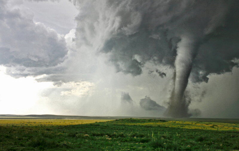
Despite these advancements, the interior of a tornado remains a “high-noise” environment for tech. The sheer amount of electromagnetic interference caused by lightning and the physical destruction of sensors means that “looking inside” is often a race against hardware failure.
The next generation of tech is focusing on “disposable” computing—low-cost, high-performance sensors that can be lost without significant financial impact, yet transmit enough data before their destruction to complete the picture. We are also seeing the rise of autonomous “interceptor” drones—UAVs designed with high-torque motors and reinforced airframes to fly directly into the inflow.
As we refine the software that processes this data and the hardware that survives the environment, our view of the “inside” of a tornado will shift from grainy, low-res images to high-fidelity, real-time 3D streams. Technology has turned the most terrifying mystery of the natural world into a quantifiable, visualizable, and ultimately, a more survivable phenomenon. The “look” inside a tornado is no longer a matter of chance; it is a triumph of digital engineering.
aViewFromTheCave is a participant in the Amazon Services LLC Associates Program, an affiliate advertising program designed to provide a means for sites to earn advertising fees by advertising and linking to Amazon.com. Amazon, the Amazon logo, AmazonSupply, and the AmazonSupply logo are trademarks of Amazon.com, Inc. or its affiliates. As an Amazon Associate we earn affiliate commissions from qualifying purchases.