
For decades, the human perception of Earth from space was defined by a single, static image: the 1972 “Blue Marble” photograph taken by the crew of Apollo 17. It was a beautiful, fragile, and solitary sphere suspended in the void. However, in the twenty-first century, what Earth “looks like” has undergone a radical technological transformation. We no longer rely on sporadic snapshots; instead, we view our planet through a sophisticated digital mirror constructed from trillions of data points, high-frequency sensors, and artificial intelligence.
Today, seeing Earth from space is less about a physical camera lens and more about a complex tech stack. From multispectral imaging to the creation of “Digital Twins,” technology has moved us from a passive observation of the planet to a real-time, high-definition immersion.
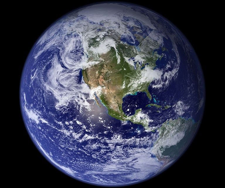
The Evolution of Orbital Imaging: From Film to Multispectral Sensors
The first images of Earth from space were grainy, black-and-white exposures captured by suborbital rockets. Today, the technology used to visualize the planet has evolved into a sophisticated array of sensors that extend far beyond the capabilities of the human eye.
High-Resolution Optical Systems
Modern satellites, such as those operated by Maxar or Planet Labs, utilize advanced CMOS (Complementary Metal-Oxide-Semiconductor) sensors that can resolve objects on the ground as small as 30 centimeters. This level of detail allows us to see Earth not just as a blue sphere, but as a living, breathing network of infrastructure and natural systems. These optical systems use complex mirror assemblies and stabilization tech to capture crisp images while traveling at speeds of over 17,000 miles per hour.
Beyond the Visible Spectrum: Hyperspectral and Infrared
What Earth looks like is no longer limited to the “visible light” spectrum. Tech-driven visualization now incorporates infrared and hyperspectral imaging. Infrared sensors allow us to “see” heat signatures, revealing the health of forests or the intensity of urban heat islands. Hyperspectral sensors break down light into hundreds of narrow bands, allowing scientists to identify the chemical composition of the atmosphere or the specific mineral content of the soil from hundreds of miles above. In this tech-driven view, Earth looks like a vibrant map of chemical and thermal energy.
Synthetic Aperture Radar (SAR)
One of the most significant leaps in Earth observation technology is Synthetic Aperture Radar (SAR). Unlike optical cameras, SAR sends microwave pulses to the Earth’s surface and measures the echoes that bounce back. This allows us to “see” the Earth through thick cloud cover, smoke, or total darkness. Through SAR technology, the planet looks like a high-contrast topographical map, providing critical data for disaster response and environmental monitoring regardless of atmospheric conditions.
AI and Machine Learning: Synthesizing the Big Data of the Blue Marble
Capturing images is only half the battle. The sheer volume of data being beamed down from thousands of satellites is overwhelming. To understand what Earth looks like today, we rely on Artificial Intelligence (AI) and Machine Learning (ML) to process and synthesize this “Big Data” into visual intelligence.
Automated Image Correction and Stitching
Raw satellite data is often distorted by the Earth’s curvature, atmospheric haze, and sensor noise. Advanced software algorithms perform “orthorectification,” a process that corrects these distortions to create a geometrically accurate view. AI-driven “cloud masking” is also used to identify and remove cloud cover from images, allowing software to stitch together “clear-sky” mosaics of the entire planet. This creates a seamless, unobstructed view of the Earth that would be physically impossible to capture in a single moment.
Predictive Analytics and Feature Extraction
AI doesn’t just look at the image; it understands it. Computer vision algorithms can automatically identify and track changes over time—such as the rate of deforestation in the Amazon or the expansion of urban sprawls in Asia. By analyzing historical data, AI can predict future changes, effectively showing us what the Earth will look like if current trends continue. This transition from descriptive to predictive visualization is a hallmark of modern space technology.
Real-Time Data Streaming
The “latency” of space imagery has dropped significantly. In the past, it took days or weeks to process space-based images. Today, edge computing—processing data on the satellite itself before it even reaches Earth—allows for near-real-time visualization. This enables us to see the Earth as a dynamic, changing entity, where events like wildfires or floods are rendered on our screens almost as they happen.
Digital Twins and the Architecture of Virtual Earths
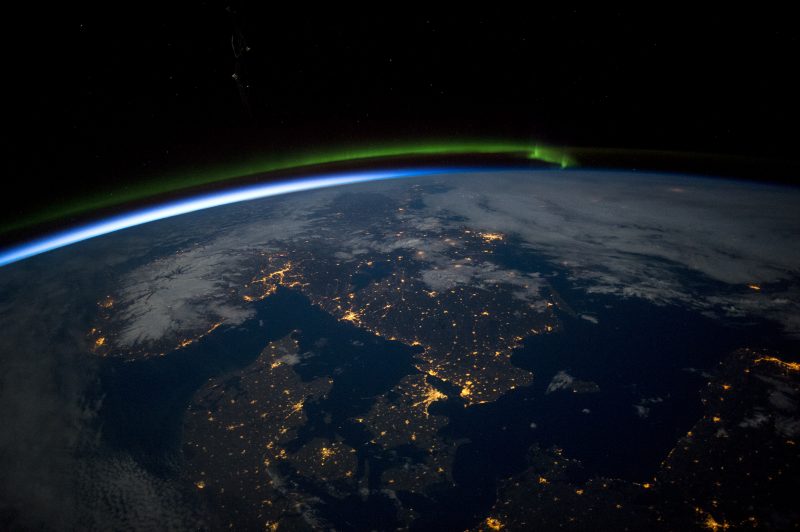
One of the most exciting trends in tech today is the creation of a “Digital Twin” of the Earth. This is not just a map, but a highly complex, 4D virtual model of the planet that integrates real-time satellite feeds with ground-based IoT (Internet of Things) sensors.
The Role of NVIDIA and Earth-2
Tech giants like NVIDIA are at the forefront of this movement. Their “Earth-2” initiative aims to create a digital twin of the Earth using supercomputing and AI. By simulating the planet’s atmosphere and magnetosphere at an unprecedented scale, researchers can visualize weather patterns with incredible accuracy. In this context, what Earth looks like is a fluid, interactive simulation that allows users to toggle through different layers of data—from sea-level rises to carbon dioxide concentrations.
Software Integration: Unreal Engine and GIS
The gaming and film industries have also contributed to how we visualize Earth. Geographic Information Systems (GIS) are now being integrated with powerful rendering engines like Unreal Engine 5. This allows for “photogrammetry,” where thousands of satellite photos are used to create 3D models of Earth’s terrain. When you explore “Earth” in a VR environment or a modern flight simulator, you are interacting with a tech-driven reconstruction of the planet that is indistinguishable from reality.
Democratizing the View: APIs and Open Data
The view of Earth from space is no longer reserved for government agencies like NASA or the ESA. Modern software APIs (Application Programming Interfaces) allow developers to integrate high-resolution satellite imagery into everyday apps. From Google Earth to logistics software that tracks cargo ships, the “Tech Earth” is now a utility, accessible to anyone with an internet connection.
Security, Connectivity, and the Infrastructure of the Global Stream
As our visualization of Earth becomes increasingly digital, the technology required to protect and transmit that data has become a critical focus of the tech industry.
Cybersecurity in the Orbital Layer
Satellites are essentially flying servers, and they are vulnerable to hacking. Protecting the “view of Earth” involves sophisticated encryption and digital security protocols. If a satellite’s data stream is compromised, the visual representation of our planet could be manipulated or blacked out. The tech sector is currently investing heavily in “space-hardened” cybersecurity to ensure that the images we receive are authentic and untampered with.
The Role of Satellite Constellations (Starlink and Beyond)
The way we receive data about Earth has changed due to the rise of Low Earth Orbit (LEO) constellations like SpaceX’s Starlink. These networks provide the high-speed, low-latency connectivity required to move massive amounts of orbital data down to Earth. This infrastructure ensures that the digital image of our planet is updated constantly, rather than being a static archive.
Edge Computing and Orbital Processing
To reduce the burden on ground stations, more “Tech” is being moved into space. Satellites are now being equipped with powerful onboard processors that can analyze images in orbit. Instead of sending a massive, high-resolution file of a forest, the satellite can use AI to detect a fire and send a small, high-priority alert. This shift toward “intelligent” satellites is changing the very nature of orbital observation.
The Future of Remote Sensing: Quantum Sensors and Beyond
As we look toward the next decade, the technology used to visualize Earth will continue to push the boundaries of physics.
Quantum Sensing
Quantum technology is expected to revolutionize remote sensing. Quantum sensors could potentially detect minute changes in Earth’s gravity or magnetic fields with a precision that current technology cannot match. This would allow us to “see” deep underground or monitor the movement of magma beneath volcanoes, adding a subterranean dimension to what Earth looks like from space.
Increased Revisit Rates
The goal of many tech startups is “persistent surveillance”—the ability to have a satellite over any point on Earth at any time. This would require constellations of thousands of SmallSats (small satellites). Once achieved, Earth will not just be a picture; it will be a live, 24/7 video feed. This will have profound implications for everything from global trade to environmental protection.

The Merging of Reality and Data
Eventually, the distinction between “looking at Earth” and “looking at data” will vanish. Through Augmented Reality (AR) and advanced visualization software, we will see the physical world overlaid with digital layers—showing us air quality, traffic patterns, and energy usage in a single, unified interface.
In conclusion, what Earth looks like in space is no longer a matter of simple optics. It is a sophisticated technological construct—a blend of high-end hardware, AI-driven software, and massive data processing. We have moved beyond the “Blue Marble” into an era of the “Digital Earth,” where our planet is visualized as a complex, data-rich, and interconnected system. This tech-driven perspective is not just about aesthetics; it is the essential toolkit we need to manage, protect, and understand our home in the digital age.
aViewFromTheCave is a participant in the Amazon Services LLC Associates Program, an affiliate advertising program designed to provide a means for sites to earn advertising fees by advertising and linking to Amazon.com. Amazon, the Amazon logo, AmazonSupply, and the AmazonSupply logo are trademarks of Amazon.com, Inc. or its affiliates. As an Amazon Associate we earn affiliate commissions from qualifying purchases.