
The 2004 Boxing Day Tsunami, triggered by the Sumatra-Andaman earthquake, remains one of the most significant seismic events in recorded history. While the human toll was devastating, from a technological and engineering perspective, the event served as a critical inflection point for seismology, oceanography, and disaster-warning software. To understand what caused the tsunami, one must look beyond the moving tectonic plates and examine the physics of the rupture, the technological limitations of early-2000s detection systems, and the data-driven evolution that has occurred since.
The Mechanics of the Megathrust: Geotechnics and Subduction Data
The primary cause of the 2004 tsunami was a massive undersea earthquake reaching a magnitude of 9.1 to 9.3. This event was a “megathrust” earthquake, occurring where the Indian Plate is subducted beneath the Burma Microplate. From a technical standpoint, the cause was a sudden release of accumulated elastic strain energy along a 1,600-kilometer (1,000-mile) segment of the fault line.
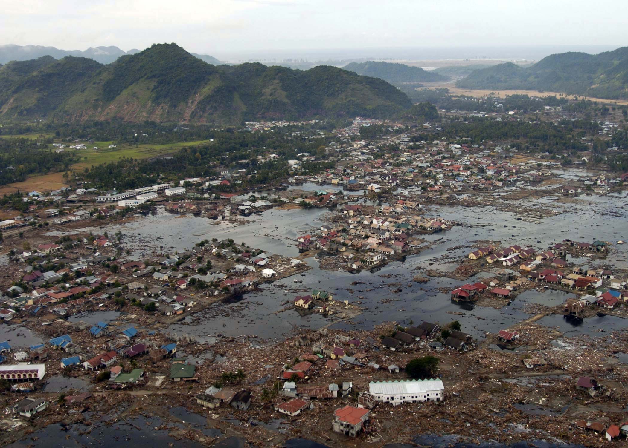
Understanding the 9.1 Magnitude Rupture
The rupture was not a singular point of failure but a sequential propagation of energy. Using modern back-projection algorithms and seismic waveform analysis, researchers have since mapped the rupture as it traveled at speeds of approximately 2.8 kilometers per second. The vertical displacement of the seafloor was the critical technical “cause” of the tsunami. In some areas along the fault, the ocean floor rose by as much as several meters, instantly displacing approximately 30 cubic kilometers of seawater.
This displacement created a massive wave train. Unlike wind-driven waves, which only affect the surface of the water, this seismic wave involved the entire column of water from the seabed to the surface. The kinetic energy involved was equivalent to over 23,000 Hiroshima-type atomic bombs. Technologically, the challenge in 2004 was the inability to measure this vertical displacement in real-time, as most seismic software at the time focused on horizontal movement and magnitude estimation rather than volumetric water displacement.
The Physics of Wave Propagation
Once the water was displaced, gravity acted as the restoring force, causing the energy to ripple outward. In the deep ocean, these waves traveled at speeds exceeding 700 kilometers per hour—comparable to a commercial jetliner. Because the wavelength was hundreds of kilometers long, the amplitude (height) in the open ocean was less than a meter, making the “cause” of the disaster invisible to ships and traditional radar systems of the era. The transformation of this energy into a destructive force occurred via “shoaling,” where the wave slows down in shallower water, causing the back of the wave to catch up with the front and the height to increase exponentially.
Systemic Failure: Why Technology Failed to Alert the Indian Ocean
While the tectonic shift was the physical cause, the scale of the disaster was exacerbated by a technological vacuum. In 2004, the Indian Ocean lacked the sophisticated sensor networks and data-sharing protocols that were already present in the Pacific. The “cause” of the high casualty rate was essentially a data transmission and infrastructure gap.
Gaps in the Global DART Network
At the time of the Boxing Day event, the Deep-ocean Assessment and Reporting of Tsunamis (DART) system was in its infancy. DART stations consist of a Bottom Pressure Recorder (BPR) that communicates with a surface buoy, which then relays data to satellites. In December 2004, there were no DART buoys deployed in the Indian Ocean. While seismologists at the Pacific Tsunami Warning Center (PTWC) in Hawaii detected the earthquake almost immediately, they lacked the hardware infrastructure in the Indian Ocean to confirm whether a tsunami had been generated.
The technology of 2004 relied heavily on land-based seismometers. While these could determine the earthquake’s magnitude and epicenter, they could not provide “wet” data—confirmation that the water was actually moving. Without sea-level gauges and pressure sensors in the region, the “cause” of the disaster remained a theoretical risk until the waves physically struck the coastlines.
Data Transmission Latency in the Pre-Cloud Era
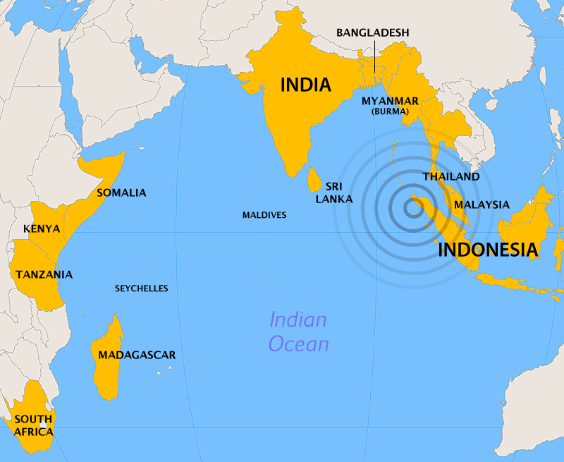
Another significant technological hurdle was the latency in data dissemination. In 2004, internet infrastructure in Southeast Asia was limited, and mobile technology was not yet capable of mass-broadcasting emergency alerts. The software used by meteorological departments was often siloed, preventing the rapid sharing of seismic data between nations. There was no centralized “API” for disaster management that could trigger automated sirens or SMS alerts across international borders. The delay between the earthquake and the first wave’s impact in Thailand and Sri Lanka was several hours—a window that modern high-speed data networks would have utilized to save countless lives.
The Evolution of Tsunami Early Warning Systems (TEWS)
Following the 2004 event, the global tech community and governmental bodies overhauled the infrastructure for maritime monitoring. The “cause” of tsunamis—seismic activity—cannot be prevented, but the technological response has been digitized and automated to mitigate the impact.
Advanced Hydrophone Arrays and Satellite Altimetry
Today, the Indian Ocean is monitored by an extensive network of DART-II and DART-ET (Enhanced Telemetry) buoys. These systems utilize sophisticated hydrophones and pressure sensors capable of detecting a change in water level as small as one millimeter at a depth of 6,000 meters. The communication software has also transitioned from low-bandwidth radio to Iridium satellite constellations, ensuring that data packets are transmitted to global monitoring centers in less than two minutes.
Furthermore, satellite altimetry—the use of radar pulses to measure the sea surface height from space—has become a secondary layer of detection. While satellites used to have significant revisit times, modern constellations provide more frequent “eyes” on the open ocean, allowing for the visual confirmation of wave propagation that was impossible in 2004.
IoT and Real-Time Buoy Connectivity
The integration of the Internet of Things (IoT) into oceanography has turned individual buoys into “smart nodes.” Modern TEWS software utilizes “edge computing,” where the sensor itself performs initial data filtering to distinguish between a tsunami wave and a passing storm surge or large vessel. This reduces the noise in the data stream and ensures that only high-probability alerts are escalated to human analysts, significantly reducing the false-alarm rate that plagued earlier versions of the software.
AI and Predictive Modeling: Preventing the Next Tech Blind Spot
The most significant shift since 2004 has been the application of Artificial Intelligence and Machine Learning to seismic data. We now understand the “cause” of tsunamis with much higher resolution thanks to digital twins and predictive algorithms.
Machine Learning in Seismic Waveform Analysis
Modern seismic software uses deep learning models to analyze “P-waves” (the fast-moving initial waves of an earthquake) to predict the likelihood of a tsunami before the slower “S-waves” even arrive. In 2004, calculating the exact magnitude of a megathrust earthquake took hours because the seismic waves “saturated” the sensors, making the earthquake look smaller than it actually was. Modern AI algorithms can now deconvolve these complex signals in seconds, providing an accurate magnitude and rupture length almost instantly.
Digital Twins and Urban Resilience Simulations
Engineers now use high-fidelity hydrodynamic models, such as MOST (Method of Splitting Tsunami) and COMCOT (Cornell Multi-grid Ocean Tsunami model), to create digital twins of coastal cities. These software tools simulate how a wave caused by a specific fault line will interact with local bathymetry (underwater topography) and urban infrastructure. By running millions of “what-if” scenarios on cloud servers, emergency planners can identify exactly which streets will flood and which buildings will survive, allowing for the technological hardening of coastal “Brand” identities and infrastructure.
Future-Proofing Global Disaster Tech Infrastructure
The 2004 Boxing Day tsunami was caused by a rare geological alignment, but its impact was a result of a technological era that was not yet interconnected. Today, the focus has shifted toward “universal connectivity.” The goal is a seamless tech stack that links a subduction zone rupture to a citizen’s smartphone in seconds.
Future developments include the use of undersea fiber-optic cables as giant seismic sensors. By using a technology called Distributed Acoustic Sensing (DAS), telecommunications companies can monitor minute vibrations in the cables that crisscross the ocean floor. This would effectively turn the global internet infrastructure into a massive, planet-sized seismometer, providing a density of data that was unimaginable in 2004.
As we continue to refine the software and hardware used to monitor our oceans, the legacy of the 2004 tsunami serves as a reminder of the vital role tech plays in human safety. We may never be able to stop the tectonic causes of these events, but through AI-driven modeling, robust sensor networks, and high-speed data transmission, we can ensure that the technological failures of the past are never repeated.
aViewFromTheCave is a participant in the Amazon Services LLC Associates Program, an affiliate advertising program designed to provide a means for sites to earn advertising fees by advertising and linking to Amazon.com. Amazon, the Amazon logo, AmazonSupply, and the AmazonSupply logo are trademarks of Amazon.com, Inc. or its affiliates. As an Amazon Associate we earn affiliate commissions from qualifying purchases.