
In the modern era, a hurricane is no longer just a meteorological event; it is a massive data challenge. As the climate shifts and storm intensity becomes more volatile, the technology used to track, predict, and respond to these giants has undergone a digital revolution. The transition from simple radar tracking to AI-driven predictive modeling and satellite-based infrared analysis has transformed how we perceive the five most recent major hurricanes: Milton, Helene, Ernesto, Debby, and Beryl.
While the human and economic toll of these storms remains significant, the technological infrastructure supporting our response systems has never been more sophisticated. From the use of autonomous underwater vehicles to high-altitude drones and neural-network-based forecasting, the “Tech Stack” of meteorology is now our primary line of defense.
The Evolution of Meteorological Tech: Monitoring the Big Five
The ability to track the five most recent hurricanes began long before they made landfall. It started in the vacuum of space and the depths of the ocean. Modern meteorology relies on a multi-layered hardware approach to gather the raw data necessary for survival.
Satellite Imagery and Remote Sensing
For storms like Hurricane Milton and Hurricane Helene, the GOES-R (Geostationary Operational Environmental Satellite) series provided the foundational data. These satellites utilize Advanced Baseline Imagers (ABI) to monitor storm development in real-time across 16 different spectral bands. This allows tech analysts to see not just the visible clouds, but the moisture levels, surface temperatures, and lightning activity within the storm’s core.
The integration of infrared technology has been crucial. By measuring the temperature of cloud tops, satellites allow meteorologists to determine the intensity of a storm’s convection. For Beryl, which became a record-breaking early-season Category 5 storm, this tech was vital in identifying rapid intensification cycles that traditional radar might have missed until it was too late.
IoT and Ground-Level Sensors
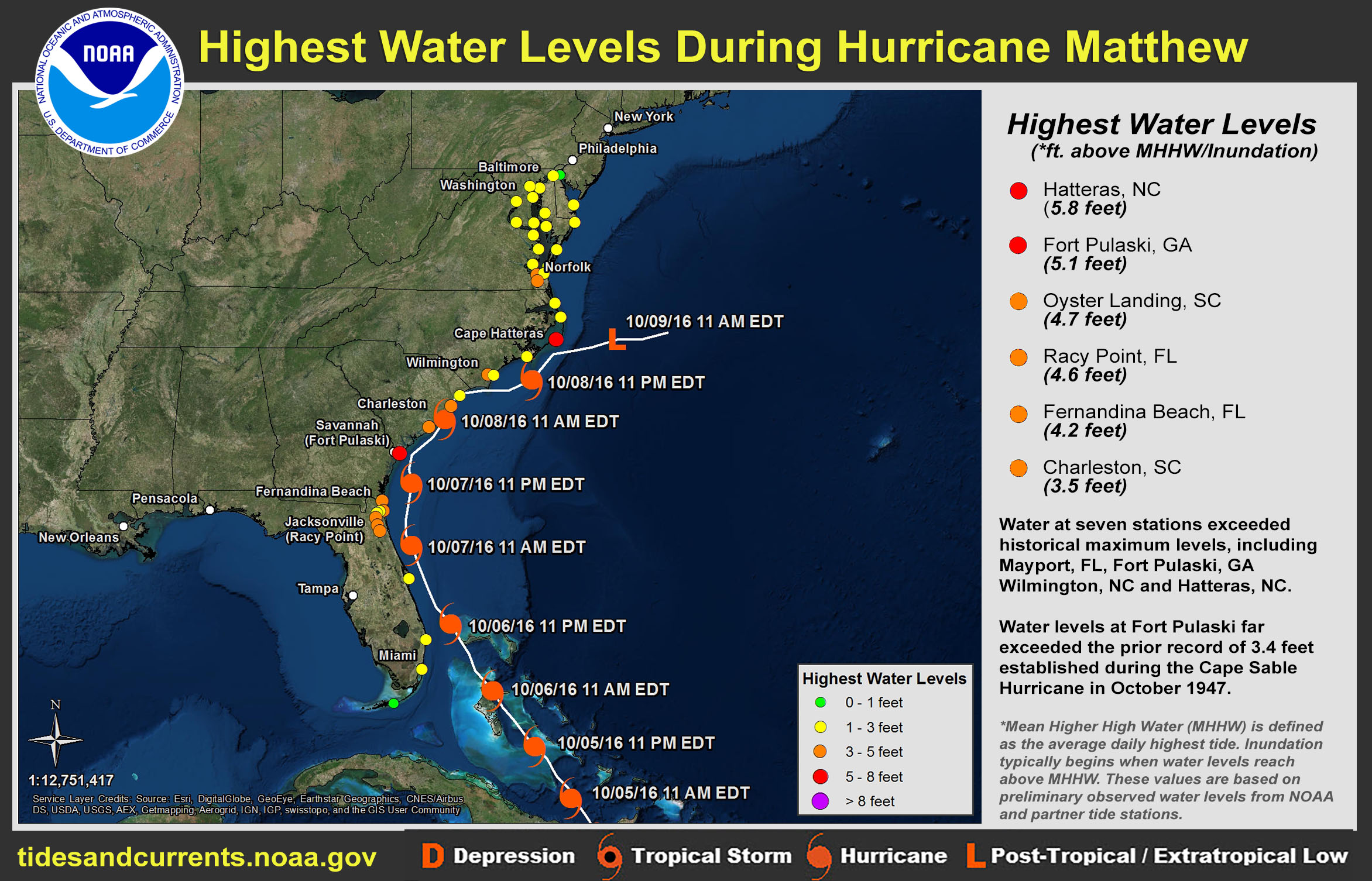
As these five hurricanes approached land, the focus shifted to the Internet of Things (IoT). Coastal regions are now outfitted with thousands of hardened sensors that measure barometric pressure, wind speed, and water levels. During Hurricane Debby, these sensors provided a granular look at storm surge that surpassed the capabilities of older, more localized stations. This data is fed instantly into cloud-based servers, allowing for “nowcasting”—the ability to provide hyper-local updates to emergency services and the public every few minutes.
AI and Machine Learning: Predicting the Path
The most significant tech shift in recent years is the move away from purely physics-based models to AI-enhanced forecasting. Traditional models like the GFS (Global Forecast System) and the European Model (ECMWF) are being augmented—and sometimes outperformed—by machine learning algorithms.
Neural Networks vs. Traditional Physics Models
When tracking Hurricane Ernesto, the use of AI models like Google’s GraphCast and NVIDIA’s FourCastNet became a focal point for tech enthusiasts and meteorologists alike. Unlike traditional models that require massive supercomputing power to solve complex fluid dynamics equations, AI models are trained on decades of historical weather data.
These neural networks can predict a hurricane’s trajectory in seconds rather than hours. During the 2024 season, these AI tools were instrumental in narrowing the “cone of uncertainty” for storms like Helene, providing a more precise target for evacuation orders. The efficiency of AI allows for thousands of “ensemble” runs, where slight variables are changed to see every possible outcome, creating a probabilistic map that is far more accurate than a single deterministic line.
Generative AI in Storm Modeling
Beyond trajectory, Generative AI is now being used to visualize potential damage. By feeding current storm data into generative engines, researchers can create high-fidelity simulations of how a 10-foot storm surge will interact with specific urban architectures. This “digital twin” technology—creating a virtual replica of a city like Tampa or Cancun—allows officials to run “what-if” scenarios, testing the resilience of power grids and drainage systems before the first raindrop falls.
Communication and Emergency Response Software

Data is only useful if it can be communicated. The 5 most recent hurricanes highlighted a shift toward resilient, high-tech communication platforms that bypass traditional infrastructure that often fails during a disaster.
Starlink and Resilient Connectivity
One of the breakout technologies during the aftermath of Hurricane Helene was the deployment of satellite-based internet, specifically SpaceX’s Starlink. When ground-based fiber optics and cellular towers were decimated, LEO (Low Earth Orbit) satellites provided the only viable link for search and rescue teams.
The tech community has also seen an uptick in the use of “mesh networking” apps. These tools allow smartphones to connect directly to one another via Bluetooth or Wi-Fi radio waves, creating a localized web of communication that doesn’t rely on a central carrier. This peer-to-peer tech has become a staple in modern disaster toolkits, ensuring that even in total blackouts, data can still flow.
Crisis Management Platforms and Apps
Government agencies have moved toward integrated SaaS (Software as a Service) platforms for disaster management. These platforms aggregate data from social media, emergency calls, and satellite feeds into a single “pane of glass” for decision-makers. During Hurricane Milton, AI-driven sentiment analysis was used to monitor social media feeds, identifying “hot zones” where people were trapped or where infrastructure had failed, often before official reports could be filed.
The Role of Big Data in Post-Storm Assessment
Once a hurricane passes, the technological work is far from over. The assessment phase for the five most recent storms has been characterized by the use of Big Data and automated visual analysis to streamline recovery.
Computer Vision for Damage Analysis
In the wake of Hurricane Beryl, insurance companies and government agencies utilized computer vision algorithms to process millions of images taken by drones and high-altitude planes. These AI systems are trained to recognize structural damage, such as missing roof shingles or flooded basements, with a high degree of accuracy.
This tech speeds up the claims process from months to days. Instead of waiting for a human adjuster to physically visit a site, a drone can fly an entire neighborhood, and the software can automatically categorize the severity of damage for every property. This “InsurTech” revolution is critical for getting capital back into the hands of survivors to begin the rebuilding process.
GIS Mapping and Hydrological Modeling
The flooding caused by Hurricane Debby required sophisticated Geographic Information Systems (GIS) to manage. By layering satellite rainfall data over topographical maps, tech teams created real-time flood maps that evolved as rivers crested. These maps are shared via open-source platforms, allowing NGOs and private citizens to see which roads are passable and which areas remain high-risk.
The integration of “Big Data” here involves combining historical flood records with current soil saturation levels and real-time precipitation. This allows for the creation of predictive hydrological models that can warn downstream communities of flooding hours before the water arrives.
The Future of Hurricane Tech: Towards Autonomous Response
As we look at the patterns of the five most recent hurricanes, the trajectory of technology is clear: we are moving toward an autonomous and proactive defense system.
The next frontier involves the deployment of “hurricane hunters” that are entirely unmanned. While the NOAA still flies manned aircraft into the eye of storms, autonomous Saildrones and underwater gliders are increasingly doing the heavy lifting. These robots can stay inside a storm for weeks, capturing data at the air-sea interface—the “engine room” of the hurricane—where it is too dangerous for humans to linger.
Furthermore, the development of smart infrastructure—sea walls that deploy automatically based on sensor data and power grids that use AI to “self-heal” by rerouting electricity around damaged nodes—represents the pinnacle of disaster tech. The 5 most recent hurricanes have served as a rigorous testing ground for these innovations. Each storm provides a new set of data points, refining the algorithms and hardening the hardware.
In conclusion, while the power of nature remains humbled, our digital arsenal is growing. The story of the five most recent hurricanes is not just a story of wind and rain; it is a story of bits and bytes, of satellites and sensors, and of the relentless pursuit of technological solutions to one of humanity’s oldest challenges. As we refine these tools, we move closer to a future where data doesn’t just track the storm—it helps us survive it.
aViewFromTheCave is a participant in the Amazon Services LLC Associates Program, an affiliate advertising program designed to provide a means for sites to earn advertising fees by advertising and linking to Amazon.com. Amazon, the Amazon logo, AmazonSupply, and the AmazonSupply logo are trademarks of Amazon.com, Inc. or its affiliates. As an Amazon Associate we earn affiliate commissions from qualifying purchases.