In an era defined by instant information and global connectivity, the seemingly simple question, “how many planes are flying right now?” unveils a sophisticated tapestry of advanced technology, intricate data networks, and the relentless pursuit of precision. It’s a query that taps into the very pulse of modern aviation, revealing not just a number, but a dynamic, real-time snapshot of one of humanity’s greatest technological achievements. Far from being a mere curiosity, the ability to track every aircraft in the sky is a testament to decades of technological innovation, underpinning safety, efficiency, and a myriad of ancillary services that touch nearly every aspect of our globalized world.
From the casual observer checking a loved one’s flight status to the air traffic controller managing a complex airspace, the technology enabling this omnipresent view of the skies is nothing short of revolutionary. This article delves into the technological underpinnings that allow us to answer this question with astonishing accuracy, exploring the systems, platforms, and future innovations that shape our digital sky.
The Invisible Infrastructure: How We Track Flights
The sheer volume of air traffic—tens of thousands of flights crisscrossing continents daily—requires an equally vast and robust technological infrastructure to monitor and manage it. This capability didn’t emerge overnight; it’s the culmination of continuous development in radar, satellite communication, and digital data processing. Understanding “how many planes are flying right now” starts with dissecting the primary data sources that feed into our global flight tracking systems.
ADS-B and Radar: The Ground-Based Network
At the heart of modern air traffic surveillance are two foundational technologies: radar and Automatic Dependent Surveillance-Broadcast (ADS-B). For decades, radar has been the workhorse of air traffic control (ATC), bouncing radio waves off aircraft to determine their position, altitude, and speed. Primary surveillance radar detects aircraft without any cooperation from the aircraft itself, while secondary surveillance radar (SSR) interrogates a transponder on the aircraft, which then replies with identifying information and altitude. While effective, radar has limitations: its range is restricted by the curvature of the Earth and terrain, creating “blind spots” over oceans and remote areas.
This is where ADS-B comes into its own. ADS-B is a cooperative surveillance technology in which an aircraft determines its position via satellite navigation and then periodically broadcasts it, enabling it to be tracked. Unlike radar, ADS-B is an “always-on” broadcast, transmitting not just position, but also velocity, heading, and other data, with higher accuracy and more frequent updates. Crucially, ADS-B signals can be picked up by relatively inexpensive ground receivers, many operated by enthusiasts, forming a dense, crowdsourced network that significantly extends coverage beyond traditional radar sites. Most commercial aircraft today are equipped with ADS-B Out, making it a cornerstone of modern flight tracking.
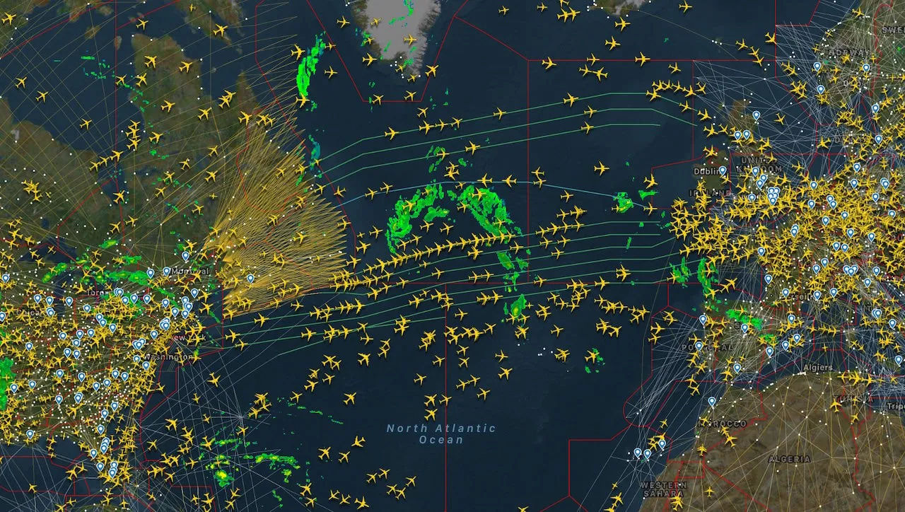
Satellite Tracking: Filling the Gaps
Despite the widespread adoption of ADS-B and the extensive radar networks, vast oceanic and polar regions remained difficult to monitor with ground-based systems. This challenge spurred the development of satellite-based ADS-B (space-based ADS-B). Companies like Aireon have deployed constellations of low-Earth orbit satellites equipped with ADS-B receivers. These satellites pick up the same ADS-B signals broadcast by aircraft, but from an orbital vantage point, providing seamless global coverage. This innovation has been transformative, eliminating large swathes of previously untracked airspace, enhancing safety, and enabling more efficient, direct flight paths over oceans, leading to significant fuel savings and reduced flight times. The ability to track every plane, everywhere, became a reality with satellite ADS-B, providing an unprecedented level of situational awareness to ATC centers worldwide.
Data Fusion and Aggregation: Creating the Global Picture
The raw data streaming from ADS-B receivers, radar stations, and satellites is immense and varied. To create a coherent, real-time picture of global air traffic, this data must be collected, processed, and aggregated. This involves sophisticated data fusion algorithms that combine information from multiple sources, reconcile discrepancies, and filter out noise. High-speed data networks ensure that this information is transmitted from thousands of ground stations and satellite gateways to centralized servers. These servers then perform complex computations, such as predicting flight paths, identifying potential conflicts, and preparing the data for distribution to various stakeholders, from air traffic controllers to public flight tracking websites. The ability to process terabytes of data every minute, with minimal latency, is a marvel of distributed computing and network engineering.
Real-Time Flight Tracking Platforms: A Technological Marvel
The culmination of this invisible infrastructure is the array of real-time flight tracking platforms that have become ubiquitous. These platforms translate complex raw data into user-friendly visual interfaces, accessible to anyone with an internet connection. They showcase the power of sophisticated software engineering, database management, and intuitive design in making highly technical information broadly consumable.
User-Facing Innovation: From FlightAware to Flightradar24
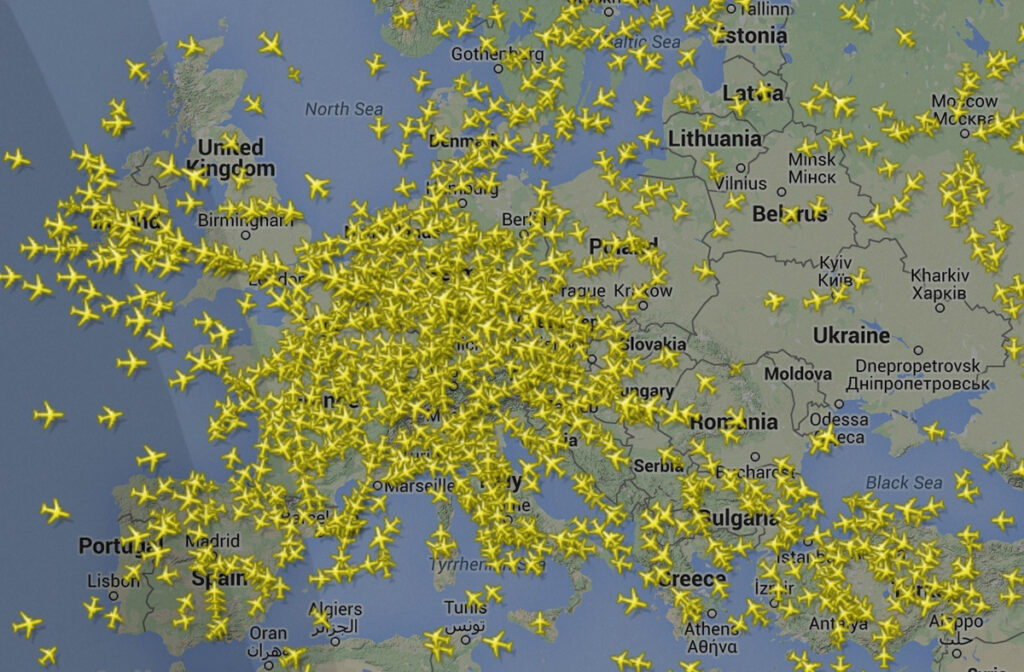
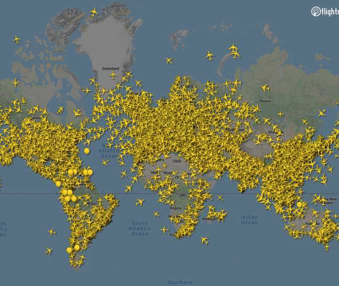
Platforms like FlightAware, Flightradar24, and Plane Finder are perhaps the most recognizable manifestations of flight tracking technology for the public. These services operate by collecting data from their own networks of ADS-B receivers (often crowdsourced from enthusiasts), official ATC feeds, and increasingly, satellite data providers. Their innovation lies not just in data acquisition but in how they present this data. Interactive maps display thousands of aircraft icons, each representing a live flight, clickable to reveal detailed information: aircraft type, airline, flight number, origin, destination, altitude, speed, and estimated arrival time.
The user experience (UX) is paramount. These platforms employ advanced mapping technologies, often leveraging APIs from Google Maps or OpenStreetMap, overlaid with custom graphical elements. Filters allow users to search for specific flights, view aircraft by type, or even observe historical flight paths. This blend of rich data visualization and intuitive navigation has transformed flight tracking from a niche interest into a mainstream activity, fueling both public curiosity and vital industry functions.
The Engineering Behind Low-Latency Data
Delivering real-time data on a global scale demands robust and scalable engineering. The challenge is not just collecting data but distributing it to millions of users simultaneously, with minimal delay. This involves:
- Massive Data Ingestion: Systems capable of receiving continuous data streams from tens of thousands of sources.
- High-Performance Databases: Optimized for real-time reads and writes, often employing in-memory databases or highly sharded architectures.
- Distributed Architectures: Cloud-based infrastructures leveraging content delivery networks (CDNs) and edge computing to serve data closer to users, reducing latency.
- Sophisticated Backend Logic: Algorithms that process and interpret raw data, identify flight segments, handle discrepancies, and manage state changes for each aircraft.
- Real-time Communication Protocols: Utilizing technologies like WebSockets to push updates to user interfaces instantly, without requiring constant page refreshes.
The engineering prowess required to maintain such complex systems, ensuring high availability and accuracy 24/7, is a significant technological achievement in itself.
APIs and SDKs: Empowering Developers and Businesses
Beyond their public-facing websites, these flight tracking platforms offer robust Application Programming Interfaces (APIs) and Software Development Kits (SDKs). These tools allow developers and businesses to integrate real-time flight data into their own applications and systems. Airlines use these APIs to provide real-time updates to passengers, logistics companies track cargo, and airports optimize ground operations. Travel agencies, news organizations, and even financial analysts leverage this data for various purposes. The availability of these programmatic interfaces underscores the value of real-time flight information as a critical component of the digital economy, enabling a new generation of data-driven services and operational efficiencies.
Beyond Tracking: AI, ML, and the Future of Air Traffic Management (ATM)
While current technologies provide an astonishing view of the skies, the future of air traffic management is being shaped by even more advanced concepts, particularly artificial intelligence (AI) and machine learning (ML). These technologies promise to move beyond mere tracking to predictive analysis, autonomous decision-making, and unprecedented levels of efficiency and safety.
Predictive Analytics for Congestion and Efficiency
The complexity of modern airspace, with thousands of aircraft interacting, creates a challenging environment for traditional human-centric air traffic control. AI and ML are poised to revolutionize this. Predictive analytics can forecast congestion at airports, anticipate potential delays due to weather or operational issues, and recommend proactive adjustments to flight schedules or routes. By analyzing historical data on flight paths, weather patterns, and traffic flows, AI models can identify optimal trajectories that minimize fuel consumption, reduce emissions, and shorten travel times, while maintaining safety margins. This moves ATC from a reactive system to a proactive, predictive one, significantly enhancing overall network efficiency.
Automation and Decision Support Systems
AI-powered decision support systems are becoming invaluable tools for air traffic controllers. These systems can process vast amounts of data—from flight plans and weather forecasts to radar and ADS-B feeds—and present controllers with actionable insights and recommended solutions for complex situations, such as managing traffic during peak hours, handling unexpected emergencies, or optimizing runway utilization. Automation, ranging from automated conflict detection to semi-autonomous sequencing of arrivals and departures, can reduce controller workload, improve response times, and enhance safety by minimizing human error.
The Dawn of Autonomous Airspace and Urban Air Mobility (UAM)
Looking further ahead, AI and ML are fundamental to enabling autonomous airspace operations and the burgeoning field of Urban Air Mobility (UAM). As drones and future flying taxis become commonplace, managing thousands of low-altitude, highly dynamic aerial vehicles will be impossible without advanced AI. AI will manage dynamic flight corridors, detect and avoid obstacles in real-time, coordinate take-offs and landings, and ensure safety in incredibly complex, three-dimensional urban environments. The ability to track, predict, and manage autonomous aircraft on a massive scale represents the next frontier in air traffic technology, promising to transform how we move people and goods within cities.
The Societal and Economic Implications of Flight Data
The real-time data revealing “how many planes are flying right now” extends its influence far beyond aviation professionals and enthusiasts. This continuously updated global dataset has profound societal and economic implications, serving as a critical resource for various sectors.
Aviation Safety and Crisis Response
For air navigation service providers (ANSPs) and regulatory bodies, comprehensive flight tracking is paramount for aviation safety. The ability to monitor every aircraft ensures that deviations from planned routes or unexpected events are immediately detected, allowing for rapid response. In times of crisis, such as natural disasters or political unrest, real-time flight data becomes indispensable for coordinating rescue efforts, managing airspace restrictions, and ensuring the safe evacuation of individuals. The post-event analysis of flight data is also crucial for accident investigation, contributing to continuous improvements in safety protocols and aircraft design.
Economic Barometers and Supply Chain Insights
Beyond aviation, flight data serves as a subtle yet powerful economic indicator. Patterns in air traffic—the number of flights, passenger load factors, cargo volumes, and the prevalence of business jets—can offer insights into global economic health, trade activity, and consumer confidence. Analysts use this data to track manufacturing output, assess supply chain resilience, and even predict market trends. For logistics and supply chain management, real-time tracking of cargo flights is critical for ensuring just-in-time delivery, optimizing inventory levels, and responding quickly to disruptions. The transparency offered by flight data empowers businesses with better planning and risk management capabilities.
Environmental Monitoring and Route Optimization
In an era of increasing environmental consciousness, flight data also plays a vital role in environmental monitoring and sustainability efforts. By analyzing flight paths, speeds, and altitudes, aviation authorities and environmental agencies can model and assess the carbon footprint of air travel. This data supports initiatives to optimize flight routes for fuel efficiency, reducing greenhouse gas emissions and noise pollution. Predictive tools, often leveraging AI, can help air traffic controllers guide aircraft through favorable atmospheric conditions or avoid areas requiring power-intensive maneuvers, contributing to a greener aviation industry.
Navigating the Digital Sky: Challenges and Opportunities
While the technological strides in flight tracking are impressive, the journey is not without its challenges. The continuous evolution of aviation and digital technology presents both hurdles to overcome and new opportunities to seize.
Data Security and Privacy Concerns
The immense volume of real-time flight data, much of it publicly accessible, raises significant data security and privacy concerns. Protecting this data from malicious attacks, ensuring its integrity, and managing access rights are critical. Furthermore, while the public benefits from transparency, there are discussions around what level of detail should be publicly available, particularly concerning sensitive flights or individual privacy. Balancing transparency with security and privacy is an ongoing challenge that requires robust cybersecurity measures and thoughtful policy development.
Regulatory Harmonization and Global Standards
The global nature of aviation means that technological solutions must contend with a patchwork of regulatory frameworks and standards across different nations and blocs. Achieving seamless global flight tracking and air traffic management requires harmonization of these regulations. International bodies like the International Civil Aviation Organization (ICAO) play a crucial role in developing common standards for ADS-B deployment, data sharing, and future ATM systems. The slow pace of international consensus can, however, hinder the rapid adoption of cutting-edge technologies.
The Continuous Pursuit of Innovation
The aviation industry is never static, and neither is the technology that supports it. The continuous pursuit of innovation drives the next generation of solutions. This includes developing more resilient communication systems, integrating quantum computing for faster data processing, and exploring holographic displays for ATC. The advent of supersonic travel, space tourism, and the widespread use of drones will demand even more sophisticated tracking and management systems. The question “how many planes are flying right now” will always have a real-time answer, but the technologies providing that answer will continue to evolve, pushing the boundaries of what is possible in our increasingly connected skies.
In conclusion, the ability to know precisely “how many planes are flying right now” is a testament to an incredible orchestration of technology. From ground-based radar and crowdsourced ADS-B receivers to orbiting satellites and sophisticated AI, a complex ecosystem of hardware and software works in concert to paint a dynamic, living picture of global air traffic. This continuous technological evolution not only ensures the safety and efficiency of air travel but also provides invaluable insights that ripple through our economy, environment, and society, making the digital sky a crucial component of our modern world.
aViewFromTheCave is a participant in the Amazon Services LLC Associates Program, an affiliate advertising program designed to provide a means for sites to earn advertising fees by advertising and linking to Amazon.com. Amazon, the Amazon logo, AmazonSupply, and the AmazonSupply logo are trademarks of Amazon.com, Inc. or its affiliates. As an Amazon Associate we earn affiliate commissions from qualifying purchases.