
At any given second, if you were to look up at the sky, you might see a solitary contrail or a blinking light navigating the stratosphere. However, that single visible aircraft is merely one pixel in a massive, high-definition digital map of global commerce and mobility. To answer the question of how many flights are in the air right now requires more than a simple headcount; it requires an understanding of a sophisticated technological ecosystem that processes millions of data points every second.
On average, at peak times during the day, there are between 10,000 and 20,000 aircraft in the air simultaneously across the globe. During the busiest periods—typically Friday afternoons in the Northern Hemisphere summer—that number can surge toward 25,000. Behind these staggering numbers lies a complex web of ADS-B transponders, satellite constellations, and ground-based receiver networks that have democratized flight data, moving it from the closed screens of Air Traffic Control (ATC) centers to the smartphones of millions.
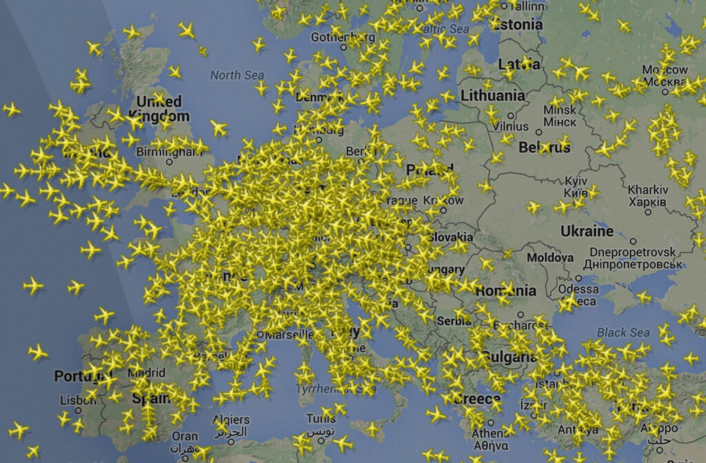
The Data Network: How We Track 10,000+ Aircraft Simultaneously
The ability to pinpoint the exact location, altitude, and velocity of thousands of aircraft is not the result of a single radar dish spinning on a hilltop. Instead, it is the product of a technological shift from primary radar to cooperative surveillance.
ADS-B Technology: The Backbone of Modern Tracking
Automatic Dependent Surveillance-Broadcast (ADS-B) is the primary technology that allows us to answer the question of “how many.” Unlike traditional radar, which works by bouncing a radio signal off an object to determine its position, ADS-B is “dependent.” The aircraft determines its own position via GPS and “broadcasts” that information, along with its altitude, speed, and flight number, at regular intervals.
This broadcast occurs on a 1090 MHz frequency. Because the signal is unencrypted and open, a global network of hobbyists and professional organizations can intercept these signals using inexpensive Software Defined Radios (SDRs). This decentralization of data collection is what allows consumer-facing platforms to aggregate a global view of the sky that was previously impossible.
Multilateration (MLAT) and Satellite Integration
While most modern commercial aircraft are equipped with ADS-B, older planes or some private jets still rely on older transponder modes (Mode S). To track these, tech platforms use Multilateration (MLAT). By measuring the “Time Difference of Arrival” (TDOA) of a signal at four or more different ground-based receivers, complex algorithms can triangulate the aircraft’s position with high precision.
Furthermore, the “black spots” of the globe—the vast oceans and remote polar regions where ground receivers cannot reach—are being filled by Space-based ADS-B. Companies like Aireon have placed ADS-B receivers on Iridium NEXT satellites, ensuring that the count of “how many flights are in the air” remains accurate even when a plane is 1,000 miles from the nearest coastline.
Software Engineering Behind the Visualization
Collecting the data is only the first half of the technological challenge. The second half is the computational heavy lifting required to visualize twenty thousand moving objects in real-time for millions of concurrent users.
Processing Millions of Data Points
Every aircraft sends out a signal at least once per second. When you multiply that by 20,000 aircraft, the sheer volume of telemetry data is immense. Tracking platforms utilize high-performance backend architectures, often built on languages like Erlang or Go, which are designed for high concurrency and low latency.
These systems must filter, validate, and normalize the data. For instance, if five different ground stations receive the same ADS-B packet from a Boeing 747 over the Atlantic, the software must deduplicate that data instantly to ensure the UI doesn’t show five ghost planes. It then merges this telemetry with static databases containing aircraft registrations, airline schedules, and historical flight paths.
The User Interface and Real-Time Rendering
The front-end challenge of displaying these flights is equally significant. Modern flight tracking apps use WebGL and specialized mapping libraries to render thousands of moving icons without crashing the user’s browser or slowing down their smartphone.
Through the use of WebSockets, a persistent connection is maintained between the client and the server. This allows the server to “push” updates to the device as they happen, rather than the device having to “poll” or ask for updates. This is why you can watch a plane turn in real-time on your screen; the technology is facilitating a live stream of geographic coordinates translated into a smooth graphical interface.
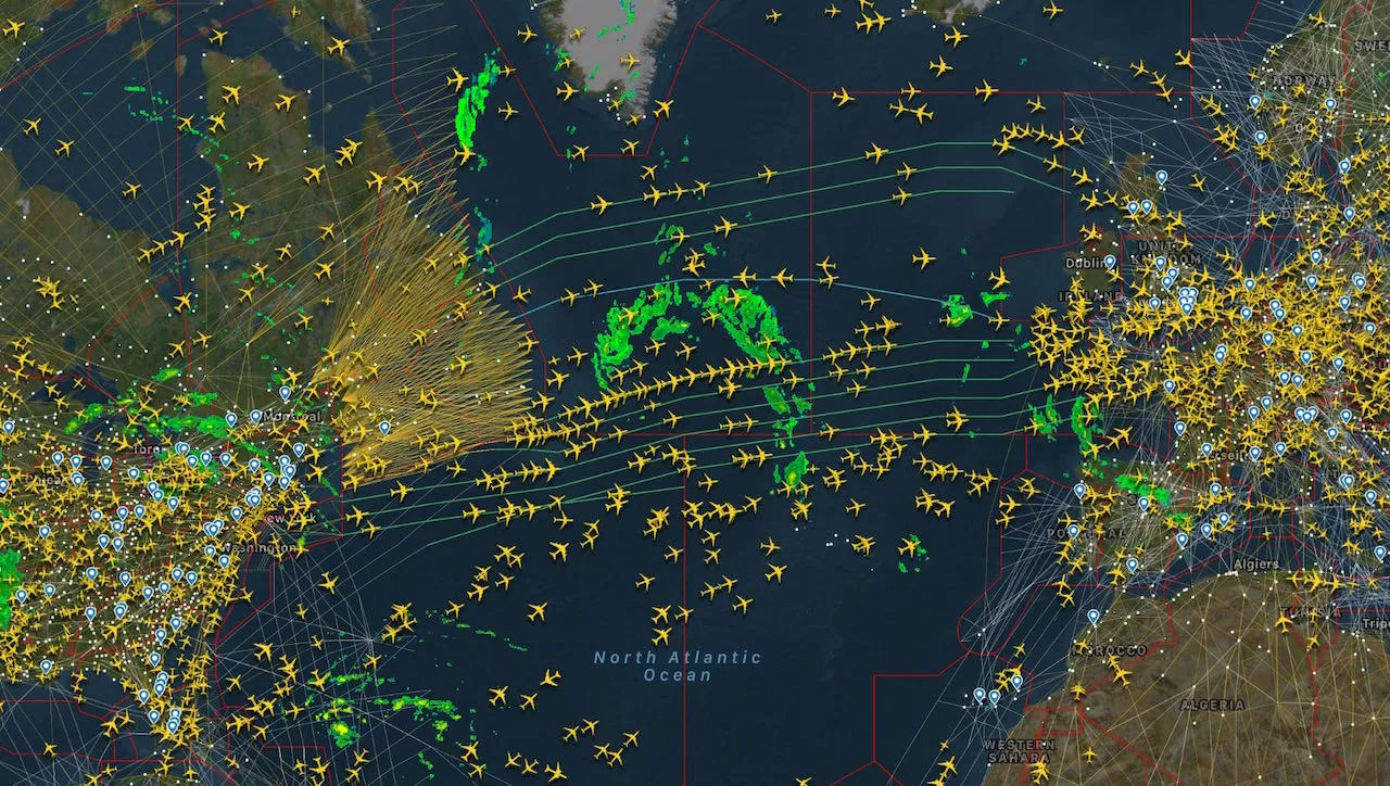
The Global Infrastructure: Servers, Sensors, and Security
To maintain a live count of global flights, a massive physical and digital infrastructure must operate 24/7. This infrastructure is a blend of volunteer-driven hardware and enterprise-grade cloud computing.
Decentralized Receiver Networks
The reason we know how many flights are over the remote regions of the Amazon or the Australian Outback is due to a network of tens of thousands of ground receivers. Many of these are hosted by individuals who use a Raspberry Pi connected to a small antenna. This “crowdsourced” hardware network provides a level of redundancy and granular coverage that even some national aviation authorities struggle to match.
The tech platforms incentivize this by providing “Enterprise” level software access to anyone hosting a receiver. This creates a symbiotic ecosystem where the community provides the raw data (the “sensors”), and the platform provides the sophisticated processing and visualization (the “intelligence”).
Data Security and Filtering
In an era of open data, security and privacy remain paramount. While the technology allows for the tracking of almost everything, “how many flights are in the air” is often a filtered number. For reasons of national security or executive privacy, certain aircraft are blocked from public view.
Software filters check the ICAO (International Civil Aviation Organization) address of every incoming signal against a “Blocked” list. This requires a robust, real-time database management system that can cross-reference thousands of signals per second without introducing lag into the live feed. The balance between transparency and security is managed through these sophisticated software gatekeepers.
Future Trends: AI and the Next Generation of Air Traffic Management
As the number of flights in the air continues to grow, the technology used to track and manage them is evolving from reactive monitoring to proactive, AI-driven orchestration.
Predicting Delays with Machine Learning
The question “how many flights are in the air” is increasingly being followed by “and which ones will be late?” Tech companies are now applying Machine Learning (ML) models to historical flight data to predict delays before they happen. By analyzing weather patterns, airport congestion, and the real-time “flow” of aircraft, AI can predict a gate arrival time more accurately than the airlines themselves.
These models look at the “state of the sky” holistically. If an AI detects a bottleneck forming over a specific waypoint in the mid-Atlantic, it can adjust the estimated arrival times for hundreds of downstream flights. This is a shift from simple tracking to predictive analytics.
Autonomous Flight and Drone Integration
The most significant upcoming change to the flight-count landscape is the integration of Unmanned Aerial Systems (UAS). In the next decade, the number of “flights” in the air could increase by an order of magnitude as commercial delivery drones and Advanced Air Mobility (AAM) vehicles (air taxis) become common.
This will require a new tier of technology: UTM (Unmanned Traffic Management). UTM systems will need to be entirely automated, utilizing AI to manage “deconfliction”—ensuring that thousands of autonomous drones don’t collide with each other or with manned aircraft. The tech stack for this will involve 5G connectivity for ultra-low latency communication and edge computing to process flight paths locally rather than relying on a central server.

The Technological Marvel of the Connected Sky
When you see the number of flights currently in the air, you are looking at more than just transportation; you are looking at a masterpiece of modern engineering. The transition from the era of “lost flights” to an era of total global visibility was made possible by the convergence of GPS, open-source hardware, cloud computing, and sophisticated software algorithms.
As we look forward, the technology that tracks these flights will become even more integral to our global economy. Whether it is reducing carbon footprints through more efficient routing or managing the complex dance of thousands of drones, the “digital sky” is becoming as structured and vital as the ground-based internet. The next time you check a flight tracking app, remember that the tiny yellow icon moving across your screen is the result of a global, high-tech symphony that never sleeps.
aViewFromTheCave is a participant in the Amazon Services LLC Associates Program, an affiliate advertising program designed to provide a means for sites to earn advertising fees by advertising and linking to Amazon.com. Amazon, the Amazon logo, AmazonSupply, and the AmazonSupply logo are trademarks of Amazon.com, Inc. or its affiliates. As an Amazon Associate we earn affiliate commissions from qualifying purchases.