
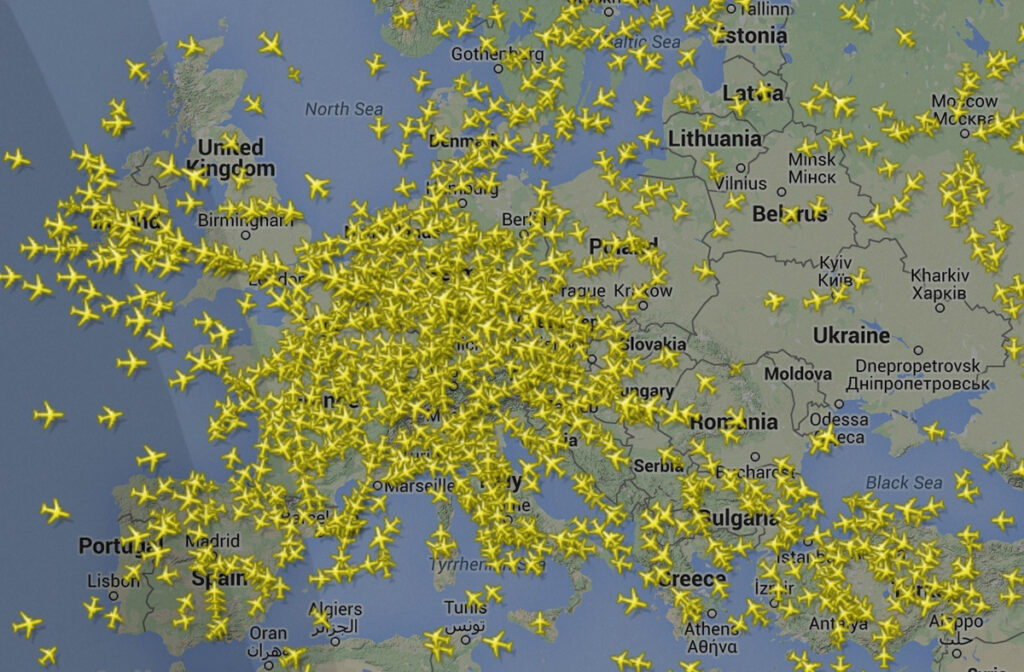
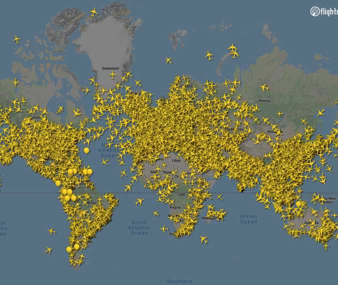
At any given moment, thousands of aircraft traverse the world’s skies, a silent ballet of precision and immense scale. From commercial airliners shuttling millions of passengers to cargo planes delivering essential goods, private jets, and military aircraft, the global airspace is a bustling, dynamic environment. The question, “how many airplanes are in the air right now?” isn’t merely a matter of curiosity; it underscores a profound technological marvel that enables us to not only know this number but to manage, track, and optimize every single flight in real-time. This article delves into the sophisticated technologies that power this intricate system, transforming an endless expanse into a meticulously organized digital sky.
The Quest for Real-Time Air Traffic Data
The ability to know the precise location and status of every aircraft aloft is not just a technological feat but a fundamental requirement for global aviation. It ensures safety, optimizes efficiency, and provides an unprecedented level of situational awareness for everyone from air traffic controllers to logistics managers and curious enthusiasts.
Why Knowing Matters: Safety, Efficiency, and Curiosity
For air traffic controllers (ATCs), real-time data is their eyes and ears, preventing collisions and guiding aircraft safely through complex airspace. Without accurate, up-to-the-second information, the sheer volume of air traffic would be unmanageable, leading to chaos and catastrophic risks. Airlines rely on this data for operational efficiency, adjusting routes for weather, managing gate assignments, and ensuring timely arrivals and departures. Ground crews use it for turnarounds, and maintenance teams for scheduling. Beyond the operational necessities, there’s a widespread public fascination. Flight tracking apps, powered by the very same underlying technologies, allow millions to track loved ones’ flights, monitor interesting aircraft, or simply marvel at the density of global air travel. This collective curiosity fuels a demand for increasingly granular and accessible flight data, pushing the boundaries of what technology can deliver.
The Evolution of Air Traffic Monitoring
From the earliest days of aviation, when pilots navigated by landmark and communicated with ground stations via rudimentary radio, air traffic monitoring has undergone a radical transformation. Post-World War II, the advent of radar provided a revolutionary leap, offering the first true “eyes” in the sky. However, early radar systems had limitations in range and detail. The subsequent decades saw continuous innovation, driven by increasing air traffic volumes and the imperative for greater safety and efficiency. This evolution has led us to the highly integrated, data-driven systems we have today, where analog signals have largely given way to digital precision, and local observations are merged into a seamless global picture. The journey has been one of continuous refinement, moving from basic positional awareness to comprehensive, predictive, and collaborative air traffic management.
Core Technologies Powering Global Aviation Tracking
The real-time tracking of thousands of aircraft relies on a synergistic blend of ground-based and satellite-based technologies, each playing a critical role in painting a complete picture of the global airspace.
Radar Systems: The Enduring Backbone
Conventional radar, an acronym for RAdio Detection And Ranging, remains a cornerstone of air traffic surveillance. Primary Surveillance Radar (PSR) emits radio waves that bounce off aircraft and return to a receiver, determining range and bearing. This passive system works without any equipment on the aircraft, making it invaluable for detecting all objects, even those not actively transmitting. However, PSR doesn’t identify aircraft. This is where Secondary Surveillance Radar (SSR) comes in. SSR actively queries an aircraft’s transponder, which then replies with a unique code, altitude, and other data. This active interrogation provides much richer information, aiding identification and altitude separation. Despite its age, radar continues to be vital, particularly for regions with high traffic density or as a fallback for other systems. However, its line-of-sight limitations mean it struggles over oceans, mountains, or remote areas.
ADS-B: The Modern Standard for Surveillance
Automatic Dependent Surveillance–Broadcast (ADS-B) represents a significant leap forward in air traffic surveillance. Unlike radar, ADS-B is a “cooperative” system where aircraft determine their position using GPS and then regularly “broadcast” this data – including identification, position, altitude, and velocity – to ground stations and other aircraft. This means aircraft are dependent on their own navigation systems and automatically broadcast their information. The “broadcast” aspect is key: any equipped receiver can pick up these signals. ADS-B offers several advantages over traditional radar: it’s more accurate, provides more frequent updates, operates at a lower cost, and extends surveillance into areas beyond radar coverage when paired with satellite receivers. Many countries, including the US and those in Europe, have mandated ADS-B Out (broadcasting capabilities) for flights in controlled airspace, making it the bedrock of modern air traffic surveillance.
Satellite-Based Tracking: Filling the Gaps
While ground-based ADS-B networks cover most populated landmasses, vast oceanic and remote regions remain outside their range. This is where satellite-based ADS-B comes into play. Companies like Aireon have deployed ADS-B receivers on low Earth orbit satellites. These satellites pick up ADS-B signals from aircraft flying anywhere on Earth, including over oceans, deserts, and polar regions, and relay that data back to ground stations. This innovation has effectively eliminated “blind spots” in global air traffic surveillance, providing seamless tracking from takeoff to landing, regardless of location. This capability is revolutionary for long-haul flights, enhancing safety, enabling more efficient oceanic routes, and reducing separation distances between aircraft, leading to fuel savings and reduced flight times.
Collaborative Data Networks: Merging Information Streams
The various surveillance technologies described above generate massive amounts of data. The true power of modern air traffic management lies in the ability to aggregate, process, and present this data in a coherent, actionable format. Collaborative data networks integrate inputs from radar, ground-based ADS-B, satellite ADS-B, flight plans, weather forecasts, and airline operational data. These sophisticated systems use complex algorithms to fuse disparate data points, filter out inconsistencies, and create a single, unified picture of the airspace. This fusion allows air traffic controllers to see all relevant information on their displays, while also feeding data to public flight tracking websites and airline operational centers. It’s the digital nervous system that connects all elements of global aviation, ensuring that every participant, from pilot to passenger, has access to the most accurate and up-to-date information available.
Software, Algorithms, and the Digital Sky
The hardware systems that collect air traffic data are just one half of the equation. The other, equally critical half, comprises the sophisticated software and algorithms that process, analyze, visualize, and distribute this immense flood of information, transforming raw signals into actionable intelligence.
Air Traffic Control Systems: Orchestrating Complexity
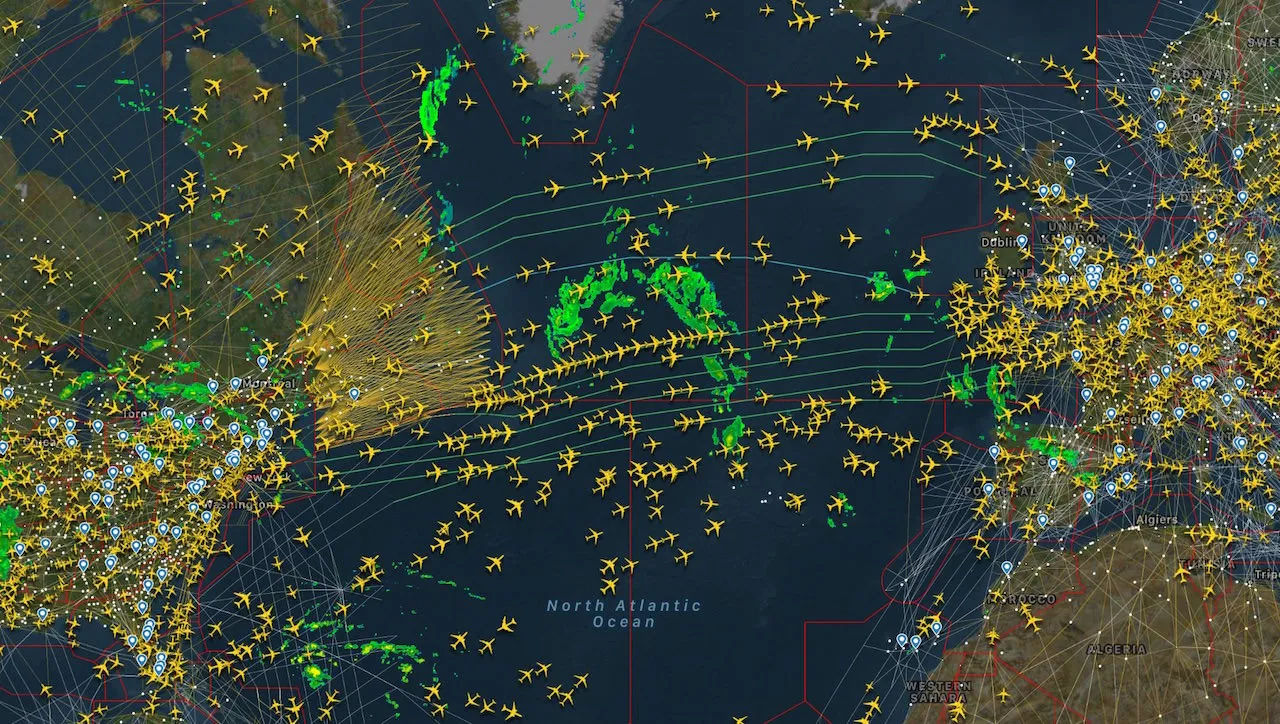
At the heart of global aviation are the advanced Air Traffic Control (ATC) systems. These complex software platforms integrate data from all surveillance sources (radar, ADS-B, flight plans), weather services, and communication systems. They provide controllers with interactive displays that show aircraft positions, altitudes, speeds, flight IDs, and projected paths. More than just visualization tools, these systems incorporate sophisticated algorithms for conflict detection, alerting controllers to potential collisions or airspace infringements. They also assist in sequencing arrivals and departures, managing traffic flow, and optimizing routes to minimize delays and fuel consumption. Modern ATC systems are designed with redundancy, cybersecurity, and scalability in mind, capable of handling surges in traffic while maintaining unwavering reliability. These systems are the digital brains that orchestrate the safe and efficient movement of millions of flights annually.
Public-Facing Flight Tracking Apps and Platforms
The same underlying data streams that feed ATC systems are also leveraged by a plethora of public-facing flight tracking applications and websites. Platforms like FlightAware, Flightradar24, and Plane Finder have democratized access to real-time flight data, allowing anyone with an internet connection to see virtually every commercial flight in the air. These apps process ADS-B signals collected by a global network of volunteers (using their own receivers) and integrate them with radar data and satellite ADS-B. The software behind these platforms translates complex aeronautical data into user-friendly graphical interfaces, displaying aircraft on a map, showing flight paths, speeds, altitudes, aircraft types, origins, and destinations. They often include additional features like historical flight data, airport delays, and weather overlays, making aviation accessible and engaging for millions worldwide.
Data Visualization and Predictive Analytics
Beyond simply showing where aircraft are, advanced software uses data visualization techniques to present complex air traffic situations clearly and intuitively. This includes customizable map layers, color-coding for different aircraft types or statuses, and graphical representations of weather fronts. More powerfully, predictive analytics algorithms are becoming increasingly integral. These algorithms analyze current traffic patterns, historical data, weather forecasts, and flight plans to anticipate future air traffic situations. They can predict potential bottlenecks, estimate arrival times more accurately, and even suggest optimal routes to avoid congestion or adverse weather. By leveraging machine learning, these systems continuously improve their predictive capabilities, offering controllers and airlines proactive insights rather than just reactive responses, thereby enhancing both safety and efficiency across the entire aviation ecosystem.
The Future of Air Traffic Management: AI, Automation, and Integration
The technological journey of air traffic management is far from over. The horizon promises even more sophisticated tools, driven by artificial intelligence, increased automation, and deeper integration, preparing the skies for unprecedented levels of traffic and new forms of aerial mobility.
Artificial Intelligence and Machine Learning in ATC
Artificial Intelligence (AI) and Machine Learning (ML) are poised to revolutionize air traffic control. AI algorithms can process vast amounts of data—from flight plans and weather to radar feeds and pilot communications—at speeds and scales beyond human capability. This allows for more sophisticated conflict detection, identifying potential issues much earlier and recommending optimal resolutions. ML models can learn from historical traffic patterns and controller decisions to predict congestion, optimize flight paths for fuel efficiency, and even forecast maintenance needs for ground equipment. AI-powered decision support tools can act as intelligent co-pilots for human controllers, offloading routine tasks, reducing workload, and enabling them to focus on critical decision-making. The goal is not to replace human controllers but to augment their capabilities, making the system more resilient, efficient, and safer.
Enhancing Safety and Efficiency Through Automation
Automation is already a significant component of modern ATC, but its role is set to expand dramatically. Future systems will feature higher levels of automated sequencing and separation, particularly in routine traffic flows. Automated departure and arrival management systems will optimize gate assignments, pushback times, and runway usage, minimizing ground delays and maximizing throughput. Automated flight path negotiation could allow aircraft to dynamically adjust routes in response to real-time conditions, without constant controller intervention, provided safety parameters are met. The challenge lies in designing automated systems that are robust, transparent, and can seamlessly integrate human oversight for unforeseen circumstances or critical decisions, ensuring that automation enhances, rather than compromises, human control and ultimate safety.
Unmanned Aerial Systems (UAS) Integration Challenges
The exponential growth of Unmanned Aerial Systems (UAS), commonly known as drones, presents both immense opportunities and significant challenges for air traffic management. Integrating hundreds of thousands, or even millions, of autonomous drones into already complex airspace alongside traditional manned aircraft requires entirely new technological frameworks. Concepts like Unmanned Traffic Management (UTM) are being developed, leveraging advanced communication, navigation, and surveillance technologies to manage drone operations at lower altitudes. This involves automated flight planning, dynamic airspace allocation, deconfliction services, and remote identification. The goal is to create a safe, scalable, and efficient system that allows for the widespread use of drones for delivery, surveillance, inspection, and urban air mobility, without compromising the safety of traditional aviation. This necessitates a robust, secure, and highly automated digital infrastructure.
Cybersecurity in the Digital Airspace
As air traffic management systems become increasingly digital, interconnected, and reliant on data exchange, cybersecurity becomes paramount. The integrity and availability of these systems are critical for national security and public safety. A breach could lead to catastrophic disruptions, loss of control, or even malicious manipulation of air traffic. Therefore, continuous investment in cutting-edge cybersecurity measures is essential. This includes robust encryption for data transmission, multi-factor authentication for access, intrusion detection and prevention systems, regular vulnerability assessments, and comprehensive incident response plans. Protecting the digital infrastructure of global aviation from cyber threats—whether from state-sponsored actors, criminal organizations, or rogue individuals—is an ongoing and evolving challenge that requires constant vigilance and innovation in digital security.
Beyond the Numbers: The Impact of Connected Skies
The ability to track every airplane in the air is more than a technical marvel; it underpins significant economic benefits and contributes to broader environmental goals. The connected skies facilitated by these technologies extend their impact far beyond the cockpit and control tower.
Economic Implications and Operational Insights
Real-time air traffic data and the systems that manage it have profound economic implications. For airlines, optimized routes, reduced delays, and more efficient gate management translate directly into massive fuel savings and operational cost reductions. Better predictability in arrival and departure times improves passenger experience, reduces missed connections, and enhances the overall reliability of air travel. For airports, efficient air traffic flow maximizes runway and terminal capacity, allowing for more flights and thus more revenue. Logistics companies can better track time-sensitive cargo, improving supply chain efficiency. Furthermore, the data itself becomes a valuable asset for market analysis, infrastructure planning, and predictive maintenance, fostering innovation and creating new economic opportunities within the aviation industry and beyond.
Environmental Monitoring and Optimized Routes
The sophisticated tracking and management systems also play a crucial role in environmental stewardship. By providing precise, real-time data, air traffic controllers and automated systems can guide aircraft along the most direct and fuel-efficient routes, avoiding unnecessary deviations and holding patterns. This “optimal trajectory management” directly reduces fuel consumption and, consequently, greenhouse gas emissions and noise pollution. Furthermore, the ability to monitor flights globally allows for better understanding of aviation’s environmental footprint. Research leverages this data to study contrail formation, atmospheric impacts, and noise patterns, informing strategies for more sustainable aviation practices. As the industry strives towards carbon neutrality, the technological backbone that enables precise flight management will be indispensable in achieving ambitious environmental targets.
In conclusion, the answer to “how many airplanes are in the air right now?” is not a static figure but a constantly fluctuating number, made observable and manageable by an extraordinary tapestry of interconnected technologies. From the venerable radar to the ubiquitous ADS-B, the far-reaching gaze of satellite tracking, and the intricate algorithms orchestrating it all, modern aviation stands as a testament to human ingenuity in conquering the third dimension. As we look to the future, with AI, advanced automation, and the integration of new aerial vehicles, the skies will only become more digitally intelligent, safer, and more efficient, showcasing an enduring commitment to technological advancement in the service of global connectivity.
aViewFromTheCave is a participant in the Amazon Services LLC Associates Program, an affiliate advertising program designed to provide a means for sites to earn advertising fees by advertising and linking to Amazon.com. Amazon, the Amazon logo, AmazonSupply, and the AmazonSupply logo are trademarks of Amazon.com, Inc. or its affiliates. As an Amazon Associate we earn affiliate commissions from qualifying purchases.