
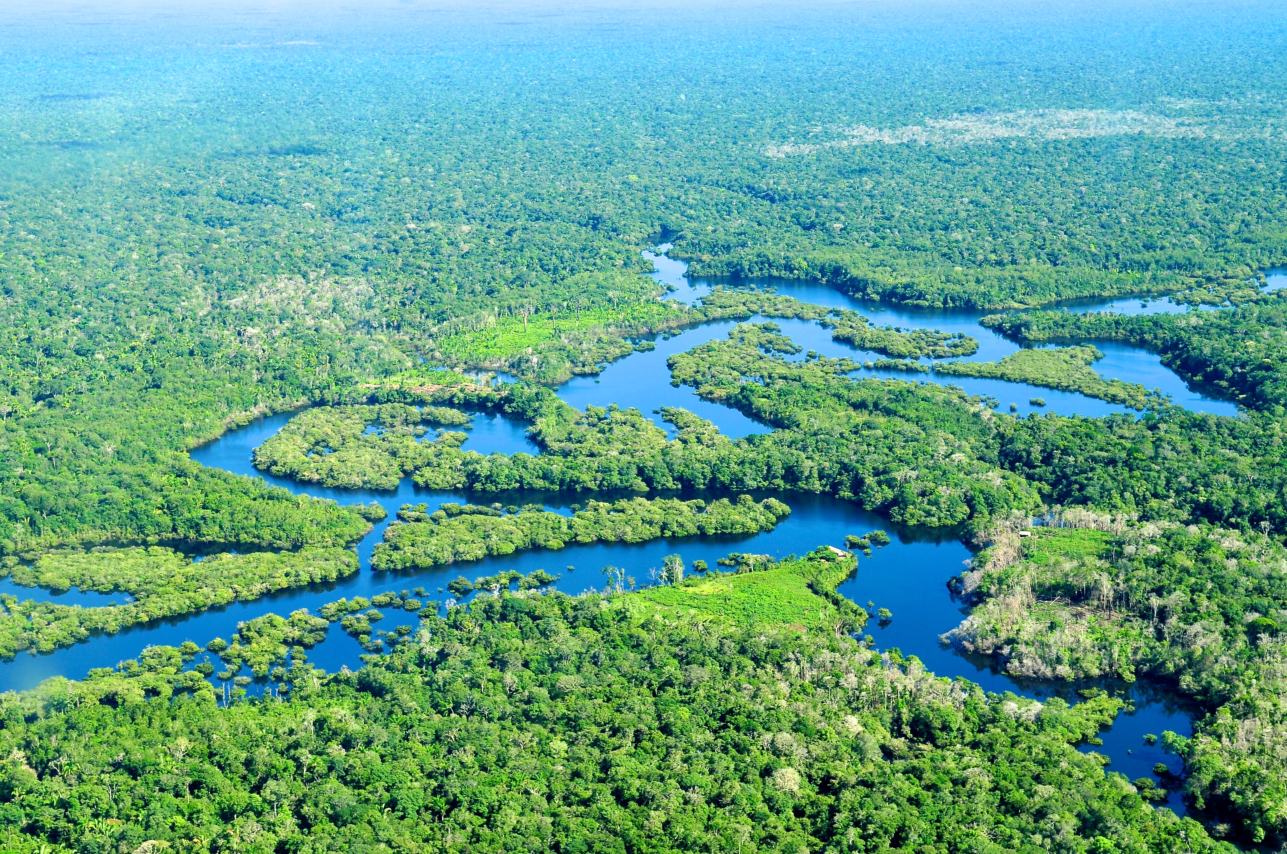
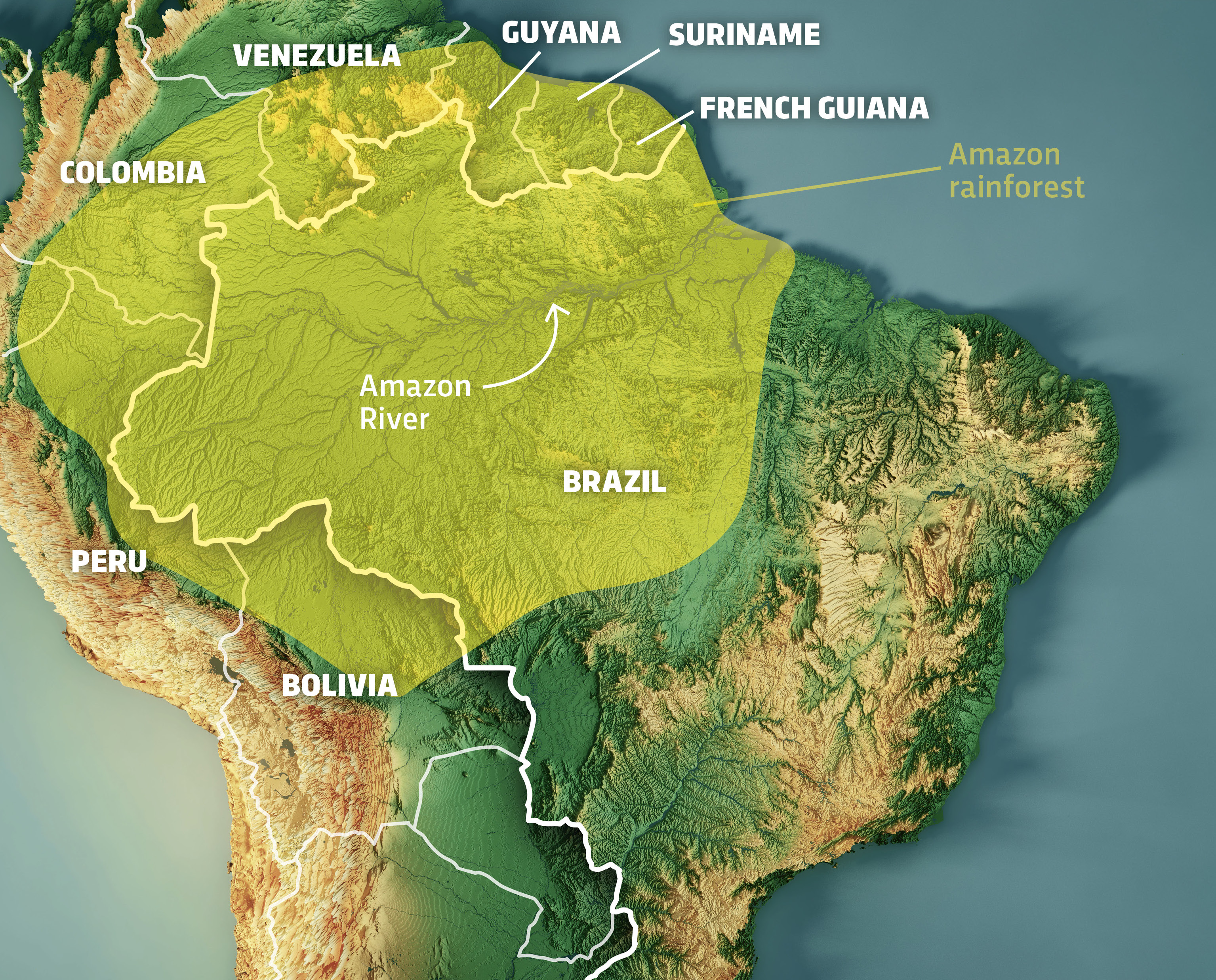
The Amazon Rainforest is often described as the “lungs of the planet,” but for data scientists, environmental engineers, and software developers, it represents one of the most complex geospatial challenges on Earth. When we ask, “how large is the Amazon Rainforest in Brazil,” we are not just looking for a static number—approximately 4 million square kilometers within Brazilian borders—but rather engaging with a dynamic, data-driven ecosystem that requires the most sophisticated technology available today to monitor, measure, and protect.
In the tech sector, the Amazon serves as a primary use case for high-resolution satellite imagery, artificial intelligence (AI), and remote sensing. Understanding the scale of this biome involves navigating layers of digital information that track changes in real-time. Brazil holds roughly 60% of the total Amazon basin, making its digital infrastructure critical for global environmental stability.
The Digital Architecture of Geospatial Monitoring
Determining the exact size of the Amazon in Brazil is a task that has evolved from ground-level surveys to high-altitude digital surveillance. The technological backbone of this effort is comprised of several interconnected systems that utilize different spectrums of light and data processing techniques.
PRODES and DETER: The Software Foundations
The National Institute for Space Research (INPE) in Brazil utilizes two primary software systems to quantify the rainforest’s expanse and health. PRODES (Program for Monitoring Deforestation in the Brazilian Amazon by Satellite) is the gold standard for annual reporting. It uses high-resolution imagery (typically from Landsat satellites) to produce an annual rate of clear-cutting.
DETER (Detection of Deforestation in Real Time), on the other hand, is an alert system. It functions like a digital security grid, identifying changes in the forest cover on a daily basis. This software is designed for speed rather than absolute precision, providing law enforcement with the “where” and “when” of land changes. For software developers, the DETER system represents a masterpiece in high-frequency data processing, handling terabytes of imagery to identify anomalies in the canopy.
Satellite Constellations and Resolution
The hardware behind the data comes from global satellite constellations. NASA’s Landsat series and the European Space Agency’s Sentinel-2 are the primary providers. Sentinel-2, in particular, has revolutionized the field by providing 10-meter resolution images that are updated every five days. This allows for a granular view of the 4 million square kilometers, enabling researchers to spot even small-scale degradation that was previously invisible to older sensors.
Private tech firms like Planet Labs have further pushed these boundaries. By deploying hundreds of “Doves” (miniature satellites), they offer daily imagery of the entire Amazon at 3-meter resolution. This “big data” approach to the environment creates a continuous digital record, allowing AI models to compare yesterday’s forest with today’s.
Artificial Intelligence and Machine Learning in Environmental Tracking
Quantifying the size of the Amazon is no longer a manual task of looking at photos. With the sheer volume of data generated by satellites, AI and Machine Learning (ML) have become indispensable tools for modern ecological monitoring.
Automated Change Detection
Machine learning algorithms, specifically Convolutional Neural Networks (CNNs), are trained to distinguish between different types of land cover. In the Brazilian Amazon, these AI tools must differentiate between primary forest, secondary growth, pasture land, and selective logging.
Training these models requires massive “ground truth” datasets. Developers use historical data from INPE to teach the AI what a healthy rainforest canopy looks like versus a degraded one. Once trained, these models can process millions of hectares in seconds, flagging illegal roads or new clearings far faster than any human analyst could.
Predictive Analytics for Deforestation
The next frontier in Amazonian tech is predictive modeling. By analyzing historical patterns—such as the appearance of illegal logging roads or the proximity of new clearings to existing infrastructure—AI tools can now predict where deforestation is likely to happen next. This “pre-emptive data” allows for proactive interventions. Tech startups are increasingly developing proprietary algorithms that fuse economic data (such as cattle prices) with geospatial data to forecast environmental impact.
Edge Computing and IoT
While satellites provide the macro-view, Internet of Things (IoT) sensors provide the micro-data. On the ground in the Brazilian Amazon, “digital guardians” use acoustic sensors equipped with AI. These devices, often recycled smartphones, are mounted to trees to listen for the sounds of chainsaws or trucks. The audio is processed at the “edge”—meaning the AI analysis happens on the device itself—and alerts are sent via satellite link to local authorities. This integration of edge computing and cloud-based alerts creates a comprehensive digital net over the forest.
LiDAR and the Move to Three-Dimensional Mapping
Knowing the horizontal size of the Amazon is only part of the equation. To understand its true scale and carbon capacity, tech professionals look to LiDAR (Light Detection and Ranging).
Measuring Biomass with Laser Precision
LiDAR technology uses laser pulses to create high-resolution 3D maps of the forest floor and the canopy structure. While traditional satellite imagery shows a “flat” green carpet, LiDAR penetrates the canopy to reveal the vertical complexity of the Amazon.
By flying LiDAR-equipped aircraft over the Brazilian Amazon, researchers can calculate the “above-ground biomass.” This tech allows us to quantify not just how many square kilometers the forest covers, but how many tons of carbon it holds. This is critical for the burgeoning carbon credit market, where precision and digital transparency are the currency.
GEDI: Space-Based LiDAR
The Global Ecosystem Dynamics Investigation (GEDI) is a specialized LiDAR instrument attached to the International Space Station. GEDI provides the tech community with the first high-resolution laser ranging of Earth’s forests. For the Brazilian Amazon, this means we now have a vertical profile of the forest that complements the horizontal data from Landsat. Integrating GEDI data into GIS (Geographic Information Systems) allows for a volumetric understanding of the Amazon’s size, which is a significant technological leap over 2D mapping.
Digital Security and Data Transparency
As the data regarding the Amazon’s size and health becomes more valuable, digital security and transparency have moved to the forefront. The tech used to monitor the forest must be immutable and verifiable to gain international trust.
Blockchain for Conservation
One of the most innovative tech trends in the Amazon is the use of blockchain to track land titles and carbon offsets. Because the Brazilian Amazon is so vast, land grabbing and fraudulent titles are persistent issues. By utilizing a decentralized ledger (blockchain), developers are creating systems where land ownership and conservation status are permanent, transparent, and unalterable.
This tech also supports the “Tokenization of the Amazon.” Companies can purchase digital tokens that represent a specific, geocoded hectare of forest. The status of that hectare is verified by the satellite and AI systems mentioned earlier, ensuring that the “asset” remains intact.
Open Data Platforms
Transparency is maintained through platforms like Google Earth Engine and Global Forest Watch. These cloud-computing platforms allow anyone—from researchers to software hobbyists—to access and analyze the data. Google Earth Engine, in particular, provides a massive computational backend that can process decades of Landsat data in a browser. This democratization of tech ensures that the “official” size of the Amazon reported by governments can be independently verified by the global tech community.
The Future of Amazonian Tech: Digital Twins
The ultimate goal for the tech industry regarding the Amazon is the creation of a “Digital Twin.” A Digital Twin is a virtual representation of a physical asset, updated in real-time with sensor data.
Real-Time Simulation
By synthesizing satellite imagery, LiDAR, IoT sensors, and weather data, developers are working toward a live 3D model of the Brazilian Amazon. This Digital Twin would allow scientists to run simulations on the impact of climate change, infrastructure projects, or policy changes before they happen in the real world.
Imagine a software interface where a user can adjust a “rainfall” slider or a “temperature” dial to see how the forest’s boundaries would recede or expand over the next 50 years. This level of sophisticated modeling represents the pinnacle of current software engineering and data visualization.

Conclusion: The Tech-Enabled Forest
So, how large is the Amazon Rainforest in Brazil? It is 4 million square kilometers of carbon, biodiversity, and moisture—but it is also a massive, multi-layered data set. The technology used to monitor this vast area has moved from simple observation to complex, real-time analysis. Through the integration of AI, satellite constellations, LiDAR, and blockchain, the tech community has turned the Amazon into one of the most monitored and analyzed places on the planet.
In the digital age, we no longer just look at the Amazon; we process it. The scale of the forest in Brazil is matched only by the scale of the technological effort required to understand it. For the software developer or the data scientist, the Amazon is not just a forest—it is a frontier for innovation, where every megabyte of data helps ensure the survival of the world’s most critical natural asset.
aViewFromTheCave is a participant in the Amazon Services LLC Associates Program, an affiliate advertising program designed to provide a means for sites to earn advertising fees by advertising and linking to Amazon.com. Amazon, the Amazon logo, AmazonSupply, and the AmazonSupply logo are trademarks of Amazon.com, Inc. or its affiliates. As an Amazon Associate we earn affiliate commissions from qualifying purchases.