
The Amazon Rainforest, a colossal expanse of biodiversity and a critical regulator of global climate, represents one of Earth’s most complex and vital ecosystems. Its sheer scale is difficult to grasp, stretching across multiple South American nations and covering an area that defies easy comprehension. For centuries, understanding the precise dimensions and intricate dynamics of this natural wonder was a monumental, often impossible, task. However, in the 21st century, the question “how big is the Amazon Rainforest?” is no longer solely a geographical inquiry but also a testament to the incredible advancements in technology. Today, we rely on sophisticated geospatial technologies, artificial intelligence, big data analytics, and an array of sensor networks to measure, monitor, and model the Amazon’s vastness with unprecedented accuracy. These technological tools not only help us quantify its immense size but also provide crucial insights into its health, the threats it faces, and the strategies required for its preservation. Without these innovations, our understanding of this planetary lung would remain rudimentary, hindering effective conservation and management efforts on a global scale.

Leveraging Geospatial Tech to Map the Amazon’s Vastness
The very definition of “how big” the Amazon is relies fundamentally on our ability to map and measure it. Traditional methods of surveying vast, often inaccessible, terrain are simply insufficient for an area spanning millions of square kilometers. This is where geospatial technology has revolutionized our capacity for environmental understanding, transforming a once-abstract concept of scale into quantifiable, data-driven insights.
Satellite Imagery and Remote Sensing
At the forefront of mapping the Amazon are satellite imagery and remote sensing technologies. Orbiting Earth at high altitudes, satellites equipped with advanced sensors continuously capture images across various spectra, from visible light to infrared and radar. These images provide a macroscopic view of the rainforest, allowing scientists to delineate its boundaries, track changes over time, and estimate its total area with remarkable precision. Missions like Landsat, Sentinel, and MODIS provide a continuous stream of data, allowing researchers to monitor everything from canopy density and biomass to water bodies and river systems.
Remote sensing goes beyond simple photography; it involves sophisticated algorithms that interpret spectral signatures to identify different types of vegetation, soil composition, and even the presence of hidden water bodies or human infrastructure. For instance, radar imagery can penetrate cloud cover and dense foliage, providing crucial data even during the Amazon’s frequently cloudy seasons. This capability is vital for consistently tracking deforestation and degradation, offering a near real-time understanding of land-use changes that would be impossible to observe from the ground or even traditional aerial surveys. The sheer volume and consistency of satellite data have transformed our ability to answer “how big” by providing the foundational data layers for all subsequent analysis.
GIS and Data Fusion for Comprehensive Views
Geographic Information Systems (GIS) are the operational backbone that transforms raw satellite data into actionable intelligence. GIS platforms allow environmental scientists and conservationists to integrate, analyze, and visualize geospatial data from diverse sources. This includes not just satellite imagery but also topographic maps, climatic data, population density maps, and even socio-economic indicators. By layering these different datasets, GIS creates a comprehensive digital model of the Amazon, offering a holistic perspective that transcends individual observations.
For instance, a GIS analyst can combine satellite-derived deforestation alerts with data on road networks, mining concessions, and indigenous territories to understand the spatial drivers of forest loss. Data fusion techniques within GIS allow for the combination of data from different sensors, resolutions, and temporal scales, creating a richer, more nuanced understanding of the rainforest’s dynamics. This capability is essential for defining the Amazon’s true size, which is not just a static boundary but a dynamic system influenced by ecological processes and human activities. GIS provides the framework to not only calculate the current size of the Amazon, estimated to be around 6.7 million square kilometers, but also to understand the context of this enormous figure, breaking it down into individual biomes, protected areas, and areas under various forms of land use. It enables a nuanced answer to “how big,” showing not just the total but the intricate geographical and ecological components.
AI and Machine Learning in Rainforest Monitoring
The monumental task of processing and interpreting the petabytes of data generated by geospatial technologies would be insurmountable without the intervention of artificial intelligence (AI) and machine learning (ML). These advanced computational methods are not just tools; they are powerful analytical engines that uncover patterns, predict trends, and automate processes that were once labor-intensive and prone to human error, thereby significantly enhancing our ability to monitor and understand the Amazon’s vastness and changes within it.
Automated Deforestation Detection
One of the most impactful applications of AI in the Amazon is the automated detection of deforestation. Traditionally, human analysts would manually review satellite images, a time-consuming and often subjective process. Machine learning algorithms, particularly deep learning models, are now trained on vast datasets of historical satellite imagery labeled with known deforestation events. These models can then analyze new satellite images with incredible speed and accuracy, identifying areas where forest cover has been removed or significantly degraded.
Systems like DETER (Detection of Deforestation in Real Time) in Brazil, which uses AI to process MODIS data, issue alerts often within days or even hours of forest clearing. This near real-time capability is crucial for rapid response by environmental enforcement agencies, allowing them to intervene before deforestation spreads further. AI’s ability to differentiate between natural forest disturbances (e.g., storm damage) and human-induced clearing (e.g., logging roads, clear-cuts) makes these alerts highly reliable. By continuously scanning the entire Amazon basin, AI algorithms provide an always-on, high-resolution watchdog, giving us an evolving, data-driven answer to “how big is the Amazon today?” and “how much of it did we lose yesterday?”.
Predictive Modeling for Environmental Changes
Beyond detection, AI and ML are instrumental in predictive modeling, forecasting future environmental changes within the Amazon. By analyzing historical trends in climate data, land use patterns, socio-economic factors, and environmental policies, machine learning models can predict areas at high risk of future deforestation, fire outbreaks, or biodiversity loss. This predictive capability is invaluable for proactive conservation strategies, allowing authorities to allocate resources more effectively and implement preventative measures.
For example, models can identify “deforestation frontiers” – areas where agricultural expansion or infrastructure projects are likely to lead to forest clearing. They can also predict the impact of various climate change scenarios on the Amazon’s unique ecosystems, helping scientists understand potential shifts in vegetation zones, water cycles, and species distribution. This moves beyond simply measuring the Amazon’s current size to understanding its future trajectory. By simulating different interventions or policy changes, AI offers insights into which strategies might best preserve the rainforest’s immense scale and ecological integrity, making the question of “how big” intrinsically linked to its resilience in the face of future challenges.
Big Data and Cloud Computing for Environmental Insight
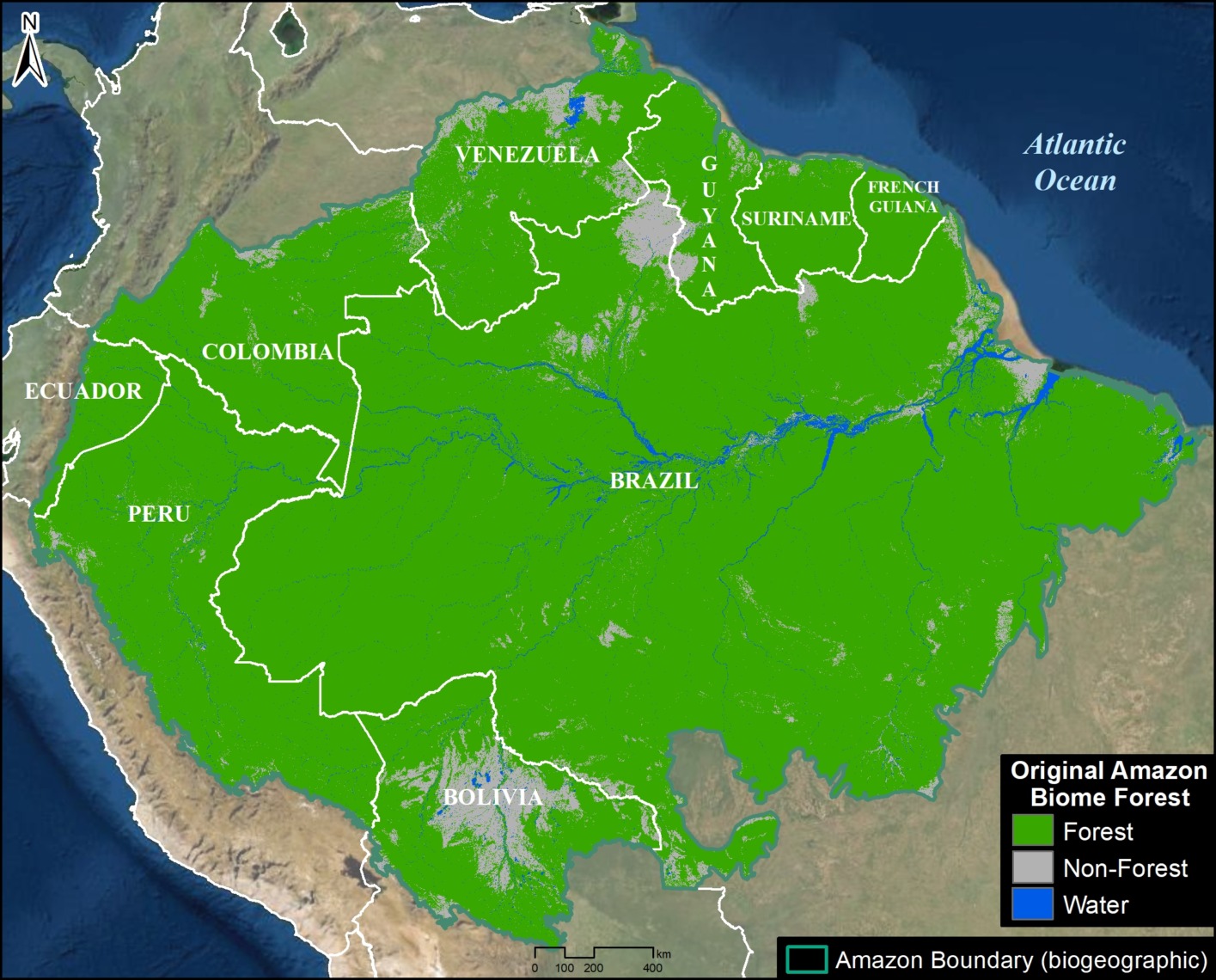
The data generated by satellites, ground sensors, and AI models across the Amazon rainforest is immense – petabytes of information collected continuously. Managing, storing, and processing this ‘big data’ requires an equally big solution, and that’s where cloud computing and advanced data infrastructure come into play. These technological frameworks are essential for transforming raw measurements into accessible, insightful knowledge about the Amazon’s scale and health.
Managing Petabytes of Geospatial Data
The volume of geospatial data related to the Amazon is staggering. Every day, multiple satellites capture images and sensor readings, adding terabytes to existing archives. This data includes high-resolution imagery, radar data, LiDAR scans, atmospheric readings, and more, spanning decades of observations. Traditional on-premise data storage and processing would be prohibitively expensive and inefficient. Cloud computing platforms, such as Google Earth Engine, Amazon Web Services (AWS), and Microsoft Azure, provide scalable, cost-effective solutions for storing these colossal datasets.
These platforms offer virtually limitless storage capacity and flexible computing power, allowing researchers to access and process vast amounts of data without needing to download it. This significantly reduces the technical barriers to entry for scientists and conservationists worldwide. Researchers can query petabytes of satellite imagery in minutes, analyzing historical trends in deforestation, land cover change, and river dynamics across the entire Amazon basin. This access to consolidated, organized big data is fundamental to accurately answering “how big is the Amazon rainforest?” and, more importantly, “how has its size changed over time?”
Collaborative Platforms for Global Research
Beyond storage, cloud computing fosters unparalleled collaboration in Amazon research and conservation. Cloud-based platforms allow multiple researchers, institutions, and government agencies from different countries to access and work with the same datasets simultaneously, regardless of their geographical location. This global cooperation is vital given that the Amazon spans nine nations and its conservation is a global concern.
These collaborative environments enable the sharing of algorithms, models, and findings, accelerating the pace of discovery and policy formulation. For instance, the SERVIR program, a joint initiative between NASA and USAID, leverages cloud technology to provide satellite-based data and decision-support tools to countries in the Amazon basin. Such platforms facilitate the integration of diverse perspectives and expertise, from indigenous knowledge to advanced scientific modeling. By democratizing access to powerful data and computational resources, cloud computing ensures that a collective, informed effort can be mounted to protect the Amazon, providing the most comprehensive and globally validated answers to the question of its true scale and the challenges it faces.
Emerging Technologies for Conservation and Sustainability
While satellites and AI provide the macro view, a new wave of localized, real-time technologies is emerging to complement these efforts, offering granular data and immediate insights into the Amazon’s health. These innovations bridge the gap between continental-scale monitoring and on-the-ground action, providing a comprehensive toolkit for answering “how big” in terms of ecological footprint and localized threats.
Drone Technology for Localized Monitoring
Drones, or Unmanned Aerial Vehicles (UAVs), are transforming localized monitoring efforts across the Amazon. While satellites provide broad coverage, drones offer unparalleled flexibility and high-resolution imagery at a much finer scale. Equipped with visible light cameras, thermal sensors, or even LiDAR, drones can capture detailed data over specific areas of interest that might be difficult or dangerous to access on foot.
Conservationists use drones to monitor small-scale illegal logging operations, track wildlife, map specific forest plots for reforestation projects, and assess the impact of localized disturbances like illegal mining or small fires. Their ability to fly low and capture ultra-high-resolution images (often down to a few centimeters per pixel) allows for the identification of individual trees, small clearings, and even poaching traps. Furthermore, drones can quickly respond to alerts generated by satellite systems, providing immediate on-site verification and detailed evidence for law enforcement. This ground-level, yet aerial, perspective refines our understanding of the Amazon’s true “size” by documenting the minute changes and localized threats that contribute to the larger picture of forest health and loss.
IoT and Sensor Networks for Real-time Data
The Internet of Things (IoT) is bringing unprecedented levels of real-time data collection directly from within the Amazon. Networks of interconnected sensors are being deployed across the rainforest to monitor a variety of environmental parameters continuously. These sensors can detect changes in temperature, humidity, rainfall, water levels in rivers, and even the sounds of chainsaws or vehicles, transmitting data wirelessly to central platforms.
A compelling example is the use of acoustic sensors that can pick up the unique sound signatures of illegal logging, gunshots (indicating poaching), or unusual wildlife activity. When a suspicious sound is detected, an alert can be sent to rangers or conservation agencies, along with GPS coordinates, enabling immediate investigation. Other IoT devices can track the movement of specific species, monitor water quality in critical river systems, or measure soil moisture to assess drought risk. This real-time, granular data augments the broader satellite observations, offering a dynamic, moment-by-moment pulse of the rainforest. By providing immediate feedback on localized conditions and threats, IoT and sensor networks are crucial for truly understanding the dynamic “bigness” of the Amazon, not just in area but in its living, breathing complexity.
Conclusion: The Evolving Answer to the Amazon’s Scale
The question “how big is the Amazon Rainforest?” has evolved dramatically with the advent of modern technology. What was once a rough estimation based on arduous expeditions and limited cartography is now a dynamic, data-driven assessment. From the orbital vantage point of satellites providing millions of square kilometers of imagery to the granular detail offered by drones and real-time insights from IoT sensor networks, technology has fundamentally reshaped our comprehension of this planetary giant.
Geospatial technologies, underpinned by powerful GIS and remote sensing capabilities, allow us to delineate the Amazon’s vast 6.7 million square kilometers with unprecedented accuracy, tracking its precise boundaries and the subtle shifts within them. Artificial intelligence and machine learning algorithms have transformed passive data into actionable intelligence, automating the detection of deforestation and predicting future environmental changes with critical foresight. The immense datasets generated by these systems are managed and analyzed through big data solutions and cloud computing, enabling global collaboration and democratizing access to vital environmental insights.
Emerging technologies like drones and IoT further refine our understanding, providing localized, real-time monitoring that complements macro-level observations. These tools collectively paint a comprehensive, ever-updating picture of the Amazon’s immense scale, its ecological richness, and the myriad threats it faces. Ultimately, the continuous advancement of technology is not just answering “how big is the Amazon Rainforest?” but also equipping humanity with the essential tools to protect, preserve, and sustainably manage this irreplaceable global treasure for generations to come. The scale of the challenge is matched only by the scale of the technological innovation dedicated to its stewardship.
aViewFromTheCave is a participant in the Amazon Services LLC Associates Program, an affiliate advertising program designed to provide a means for sites to earn advertising fees by advertising and linking to Amazon.com. Amazon, the Amazon logo, AmazonSupply, and the AmazonSupply logo are trademarks of Amazon.com, Inc. or its affiliates. As an Amazon Associate we earn affiliate commissions from qualifying purchases.