
The phrase “Ice Age” conjures images of colossal glaciers, woolly mammoths roaming frozen plains, and a dramatically altered global landscape. While our ancestors experienced this harsh reality firsthand, our understanding today is largely a product of scientific inquiry, powered by increasingly sophisticated technological tools. Far from being a purely historical or paleontological pursuit, unraveling the appearance of the world during the Pleistocene epoch—the last glacial period—is a testament to the power of modern technology, from high-resolution imaging and data analysis to complex climate modeling and virtual reconstruction. This article delves into how technology illuminates the Ice Age, allowing us to “see” a world that existed thousands of years ago, understand its dynamics, and draw crucial lessons for our present and future.
Reconstructing the Glacial Landscape: From Fossil Fuels to Digital Archives
The initial glimpses into the Ice Age environment were, by necessity, piecemeal and reliant on direct, often arduous, fieldwork. However, technology has revolutionized our ability to gather, analyze, and visualize this data, transforming speculative reconstructions into robust, evidence-based narratives.
The Technological Toolkit of Paleoclimatology
Paleoclimatology, the study of past climates, is a field profoundly shaped by technological innovation. Core sampling, a cornerstone of this discipline, has been dramatically enhanced by advanced drilling techniques and materials. Ice cores, extracted from the ancient ice sheets of Greenland and Antarctica, act as invaluable archives, containing trapped air bubbles that preserve atmospheric composition from millennia ago. Sophisticated gas chromatography and mass spectrometry techniques are then employed to analyze these bubbles, revealing precise concentrations of greenhouse gases, isotopes of oxygen and hydrogen (which provide temperature proxies), and even volcanic ash layers that help with dating.
Similarly, sediment cores, extracted from the ocean floor and lakebeds, provide a rich tapestry of environmental information. Advanced sonar and seismic imaging technologies allow researchers to map subsurface geological structures and identify potential coring sites. Once retrieved, these cores are subjected to high-resolution X-ray fluorescence (XRF) and other elemental analysis techniques to identify mineral content, offering clues about erosion patterns, sediment sources, and past vegetation. For marine sediments, the analysis of fossilized microorganisms, such as foraminifera, using advanced microscopy and genetic sequencing, provides detailed information about sea surface temperatures, ocean currents, and salinity.
Digitizing and Visualizing Ancient Worlds
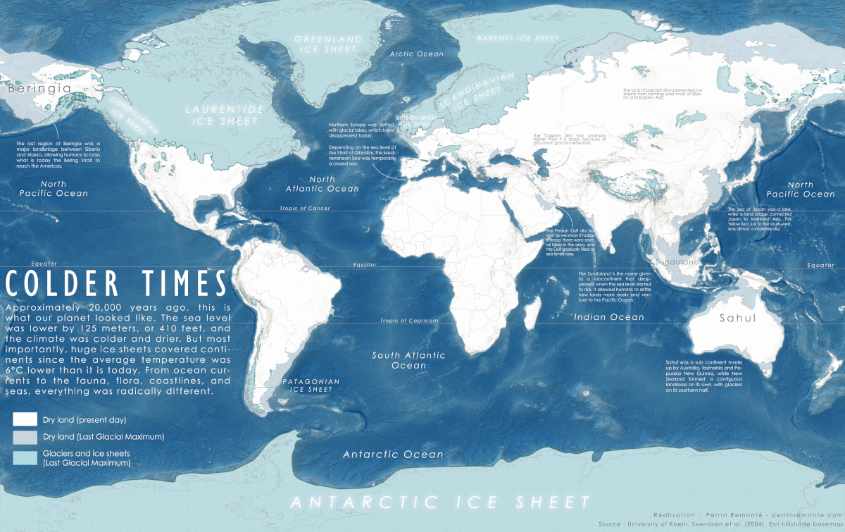
Beyond data acquisition, the interpretation and presentation of Ice Age data have been transformed by digital technologies. Geographic Information Systems (GIS) have become indispensable for integrating vast datasets from various sources—paleoclimate records, geological surveys, fossil distribution, and genetic studies. GIS allows scientists to create dynamic maps that illustrate the extent of ice sheets, sea levels, vegetation zones, and animal migration routes across different periods of the Ice Age. These digital maps are not static representations; they can be layered and animated, providing a visual narrative of environmental change over time.
Furthermore, advancements in 3D scanning and photogrammetry have enabled the creation of highly detailed digital models of fossils, geological formations, and even ancient hominin sites. This allows researchers worldwide to collaborate on and study these artifacts without the need for physical transport, fostering a more open and efficient scientific process. The integration of these diverse digital datasets with high-performance computing has paved the way for a more comprehensive and nuanced understanding of the Ice Age environment, moving beyond anecdotal evidence to data-driven reconstructions.
Simulating Ice Age Ecosystems: The Power of Computational Models
While direct observation is impossible, computational modeling offers a powerful technological lens through which to simulate and understand the complex interactions that defined Ice Age ecosystems. These models move beyond simply describing the environment to exploring its dynamics and the factors that shaped life within it.
Climate Models: Recreating the Global Thermostat
The development of sophisticated Global Climate Models (GCMs) has been instrumental in understanding the drivers and consequences of glacial cycles. These models, built upon fundamental laws of physics and chemistry, simulate the Earth’s climate system, including the atmosphere, oceans, ice sheets, and land surfaces. By inputting specific boundary conditions representative of the Ice Age—such as orbital parameters, atmospheric CO2 concentrations, and land ice distribution—scientists can run simulations that aim to replicate the observed climate of the past.
These GCMs help researchers understand how variations in Earth’s orbit (Milankovitch cycles) triggered the advance and retreat of ice sheets, how atmospheric circulation patterns shifted, and how these changes impacted temperature and precipitation globally. The output of these models, often visualized through advanced rendering techniques, provides researchers with detailed maps of global temperature anomalies, wind patterns, and precipitation distributions, allowing for direct comparison with paleoclimate proxy data. This iterative process of model refinement and data validation is crucial for improving our understanding of climate system feedbacks and the sensitivity of the Earth to different forcings.
Ecological and Biogeographical Simulations

Beyond broad climate patterns, technology allows for the simulation of ecological dynamics and biogeographical shifts during the Ice Age. Species distribution models (SDMs), powered by statistical algorithms and GIS data, predict the potential range of plant and animal species under past climatic conditions. By analyzing fossil records and modern species’ environmental tolerances, these models can reconstruct the likely habitats of Ice Age megafauna, such as the woolly rhinoceros and the cave bear, and map out their migration corridors.
Furthermore, agent-based models are beginning to be used to simulate the behavior and interactions of individual organisms within Ice Age ecosystems. These models can explore how factors like food availability, predator-prey dynamics, and competition might have influenced population sizes and distributions. This level of granular simulation, while computationally intensive, offers profound insights into the resilience and vulnerability of Ice Age life and provides valuable context for understanding current biodiversity challenges. The ability to simulate these complex systems digitally allows us to test hypotheses and explore scenarios that would be impossible to study directly.
Virtual Realities of the Past: Immersive Exploration and Educational Outreach
Perhaps one of the most engaging technological advancements for understanding the Ice Age lies in the realm of virtual reality (VR) and augmented reality (AR). These immersive technologies offer a transformative way to experience and learn about past environments.
VR: Walking Among Giants and Glaciers
Virtual reality platforms, utilizing sophisticated 3D rendering engines and vast datasets, are enabling the creation of highly realistic simulations of Ice Age landscapes. Imagine donning a VR headset and finding yourself standing on a windswept Ice Age steppe, observing a herd of mammoths in the distance, or feeling the chilling presence of a massive ice sheet. These VR experiences are not mere entertainment; they are carefully crafted based on scientific data and reconstructions, translating complex geological and biological information into an immersive and understandable format.
These virtual environments allow users to explore different regions of the world at various points during the Pleistocene, witnessing firsthand the dramatic differences in geography, flora, and fauna compared to today. Interactive elements can allow users to zoom in on specific details, trigger informational overlays about the depicted species or geological features, and even experience simulated weather events. This direct, visceral engagement fosters a deeper appreciation for the scale and nature of Ice Age changes.
AR: Bringing the Ice Age into the Present
Augmented reality applications offer another innovative way to connect with the Ice Age. Imagine using your smartphone or tablet to project a life-sized 3D model of a saber-toothed cat onto your living room floor, or to overlay a map of ancient Ice Age coastlines onto your current view of a familiar beach. AR technologies can overlay digital information and imagery onto the real world, allowing for dynamic and interactive learning experiences.
Museum exhibits are increasingly incorporating AR to bring ancient creatures to life, allowing visitors to see skeletal structures, understand movement, and learn about habitats. Educational apps can use AR to guide users through virtual Ice Age field trips, identifying reconstructed plant life or showing the geological processes that shaped the landscape. The accessibility of AR on common devices democratizes access to these incredible insights, making the study of the Ice Age more engaging and educational for a wider audience.
Legacy and Future: Lessons from the Ice Age in a Digital Age
The technological journey to understand the Ice Age is far from over. Each breakthrough in data acquisition, analysis, and visualization refines our picture of this critical period in Earth’s history. The lessons learned from studying glacial cycles, including the impact of climate change on ecosystems and human populations, are more relevant than ever in our current era of rapid environmental shifts.
Leveraging Past Climate Data for Future Predictions
The detailed climate reconstructions and simulations of the Ice Age provide invaluable analogues for understanding the potential impacts of anthropogenic climate change. By comparing the speed and magnitude of natural climate shifts during the Pleistocene with current warming trends, scientists can better predict the rate and extent of future environmental changes. The technological tools developed to study the Ice Age—from ice core analysis to advanced GCMs—are now being applied and refined to model future climate scenarios, helping policymakers and societies prepare for the challenges ahead.

The Evolving Role of AI and Big Data
The future of Ice Age research, like many scientific fields, will be increasingly shaped by artificial intelligence (AI) and big data analytics. AI algorithms can process and identify patterns in massive datasets from satellite imagery, remote sensing, and geological surveys that would be impossible for humans to sift through manually. This could lead to the discovery of new Ice Age sites, the identification of previously unrecognized ecological connections, and more precise dating of geological events. Machine learning is also being used to improve the accuracy and resolution of climate models, allowing for more nuanced projections. As technology continues to advance, our ability to visualize, simulate, and understand the world during the Ice Age will only become more profound, offering crucial insights into the Earth’s past, present, and future.
aViewFromTheCave is a participant in the Amazon Services LLC Associates Program, an affiliate advertising program designed to provide a means for sites to earn advertising fees by advertising and linking to Amazon.com. Amazon, the Amazon logo, AmazonSupply, and the AmazonSupply logo are trademarks of Amazon.com, Inc. or its affiliates. As an Amazon Associate we earn affiliate commissions from qualifying purchases.