The Amazonas, a name that evokes images of unparalleled biodiversity, sprawling rivers, and dense, mysterious rainforests. It represents not just a geographical region but a vital global lung, a unique ecosystem, and a cultural heartland for countless indigenous communities. But in an era of rapid change, the question “Where is the Amazonas?” transcends simple cartography. It becomes a complex query about its precise location, its dynamic health, the threats it faces, and its evolving role in a digitally interconnected world. Answering this question effectively, with the depth and urgency it demands, now fundamentally relies on a sophisticated array of technological advancements. From satellite imagery that maps its furthest reaches to artificial intelligence that predicts environmental shifts, technology is redefining our understanding and interaction with this irreplaceable natural wonder.

Geospatial Technologies: Pinpointing the Amazon’s Vastness
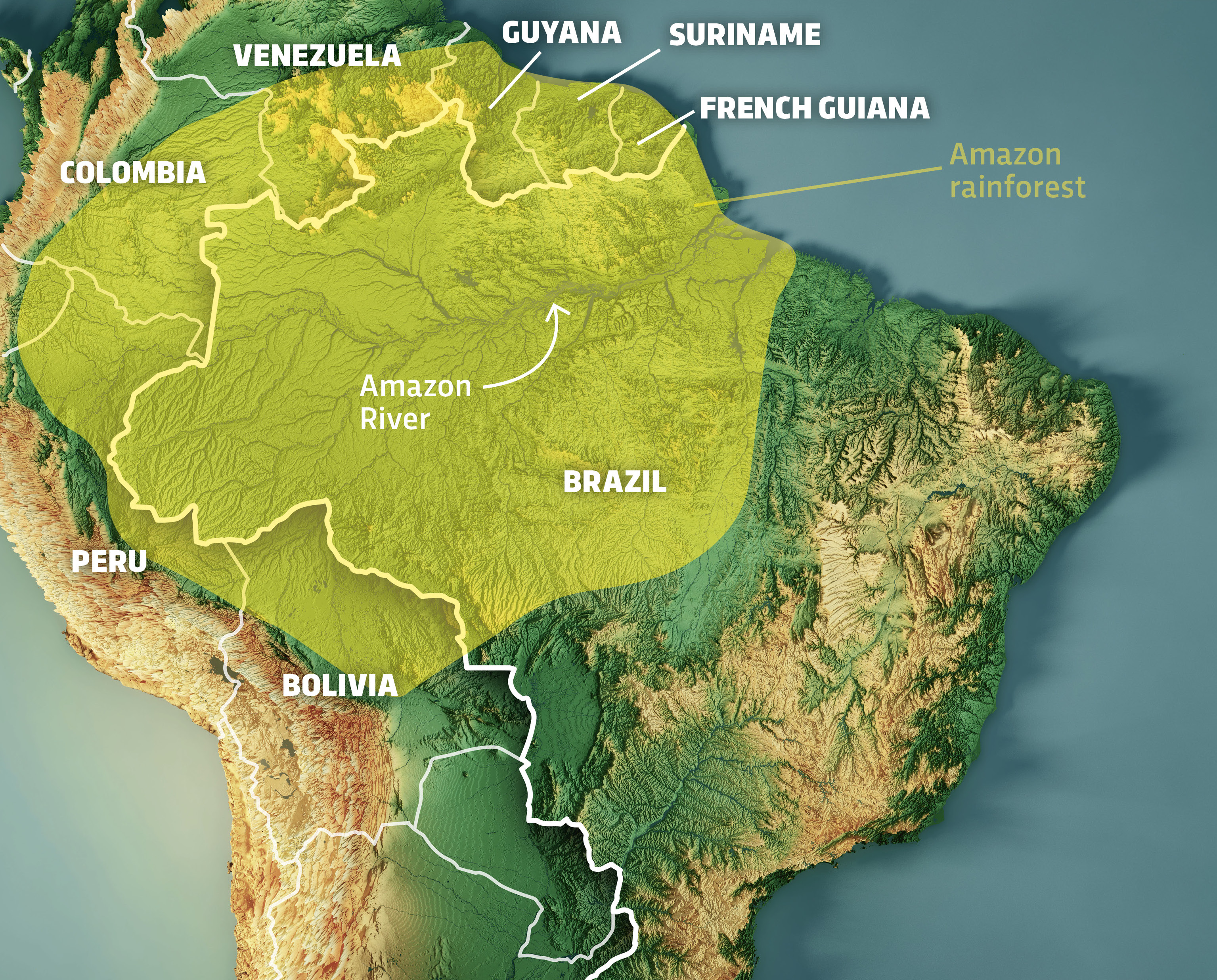
Understanding “where” the Amazonas is, in its most fundamental sense, begins with precise geographic identification. The Amazon Basin spans over 7.05 million square kilometers, encompassing territory across nine South American countries: Brazil, Peru, Ecuador, Colombia, Venezuela, Bolivia, Guyana, Suriname, and French Guiana. Its sheer scale and often inaccessible terrain make traditional ground-based surveying an insufficient method for comprehensive mapping and monitoring. This is where geospatial technologies become indispensable, offering a bird’s-eye view and granular detail previously unimaginable.
Satellite Imagery and Remote Sensing
At the forefront of locating and monitoring the Amazonas are satellite imagery and remote sensing technologies. Satellites like those in the European Space Agency’s Copernicus program (Sentinel series) and NASA’s Landsat missions provide continuous, high-resolution data that tracks everything from deforestation rates to water levels in the Amazon River and its tributaries. Synthetic Aperture Radar (SAR) systems, in particular, can penetrate cloud cover and vegetation, offering crucial data on forest structure and biomass, even during the Amazon’s perpetually cloudy rainy seasons. These images are not just static pictures; they form dynamic datasets that, when analyzed over time, reveal trends in land use change, illegal mining operations, and the overall health of the forest cover. This continuous stream of data allows researchers, conservationists, and governments to pinpoint exactly where environmental degradation is occurring, enabling targeted interventions and informing policy decisions.
Geographic Information Systems (GIS) and Drone Technology
Beyond raw satellite data, Geographic Information Systems (GIS) provide the crucial framework for organizing, analyzing, and visualizing this vast geographical information. GIS platforms integrate satellite images with ground-truth data, topographical maps, and socio-economic information, creating comprehensive digital models of the Amazon. This allows for multi-layered analysis, such as identifying biodiversity hotspots, mapping indigenous territories, or tracking the spread of fires. Complementing the macro view from satellites, drone technology offers unparalleled detail at a localized level. Drones equipped with high-resolution cameras, LiDAR (Light Detection and Ranging), and multispectral sensors can survey specific areas with extreme precision, providing detailed data on forest canopy health, wildlife populations, and human encroachment. This hyper-local information is vital for validating satellite data, conducting targeted ecological studies, and supporting enforcement efforts against illegal activities.
AI and Data Science: Understanding the Amazon’s Complexities
Knowing “where” the Amazonas is physically located is just the starting point. To truly understand its dynamic nature and future trajectory, technology must move beyond simple mapping to sophisticated analysis and predictive modeling. Artificial intelligence (AI) and advanced data science are transforming our ability to interpret the enormous datasets generated by geospatial technologies, offering deeper insights into the complex ecological processes and anthropogenic impacts shaping the region.
Predictive Analytics for Environmental Monitoring
The sheer volume of data emanating from the Amazon—from climate sensors, satellite images, and biodiversity surveys—is too vast for human analysts alone. AI, particularly machine learning algorithms, excels at sifting through this data to identify patterns, anomalies, and emerging threats. For instance, AI models are now trained to detect deforestation in near real-time by analyzing changes in satellite imagery, often flagging illegal logging activities faster than human observation could. These systems can also predict areas at high risk of future deforestation based on historical trends, road development, and land tenure patterns. Furthermore, AI helps in modeling the impacts of climate change on Amazonian ecosystems, predicting shifts in rainfall, temperature, and species distribution, which are crucial for developing proactive conservation strategies.
Biodiversity Informatics and Species Tracking
The Amazon is home to an estimated 10% of the world’s known species, many of which remain undiscovered or poorly understood. AI and data science are revolutionizing biodiversity informatics, helping scientists process vast amounts of genetic, photographic, and acoustic data to identify species, track populations, and understand ecological relationships. Machine learning algorithms can analyze vast datasets of camera trap images and audio recordings to automatically identify species, monitor their movements, and assess their health without human disturbance. This technological approach allows for more comprehensive and less invasive biodiversity surveys, providing crucial insights into where specific species are located and how their distributions are changing in response to environmental pressures. These tools are indispensable for conservation efforts, guiding decisions on protected areas and informing strategies for species recovery.
Connectivity and Communication: Bridging the Digital Divide
The question “Where is the Amazonas?” also relates to its place in the global information network. Despite its immense ecological significance, many parts of the Amazon remain physically and digitally isolated. Bridging this digital divide is crucial not only for empowering local communities but also for enhancing monitoring, data collection, and rapid response efforts for conservation. Technology aimed at improving connectivity is essential for bringing the Amazonas into the digital age, enabling real-time information flow from its heart to the wider world.
Satellite Internet and Local Networks
Traditional terrestrial internet infrastructure is virtually non-existent in much of the remote Amazon. However, advancements in satellite internet technology are beginning to change this. Low Earth Orbit (LEO) satellite constellations, such as Starlink, offer the potential for high-speed, low-latency internet access even in the most isolated communities. This connectivity is transformative, allowing indigenous groups to access educational resources, telemedicine, and global markets for sustainable products. For environmental efforts, it means that remote monitoring stations can transmit data in real-time, field researchers can upload findings instantly, and conservation agencies can coordinate responses more effectively, regardless of how deep into the rainforest they are. Complementary to satellite internet, the development of localized mesh networks and community-managed internet solutions using Wi-Fi and radio frequencies are also playing a vital role in connecting villages, offering affordable and sustainable access where larger infrastructures are impractical.
Mobile Technology for Community Empowerment and Data Collection
Mobile technology, even in its simpler forms, is a powerful tool for empowering Amazonian communities and enabling citizen science. Basic smartphones, increasingly accessible even in remote areas, allow local inhabitants to document environmental changes, report illegal activities, and communicate directly with authorities and conservation organizations. Apps designed for participatory monitoring enable indigenous rangers to record observations of wildlife, deforestation, or pollution, often geotagging their reports for precise location tracking. This not only provides valuable ground-truth data that complements satellite imagery but also strengthens local ownership over conservation efforts. Furthermore, mobile platforms facilitate the sharing of traditional ecological knowledge, promoting cultural preservation and intergenerational learning within and beyond the Amazonian region.
Emerging Tech: Innovating for Amazonian Preservation
The quest to fully comprehend and protect the Amazonas is an ongoing challenge that demands continuous innovation. As new technologies emerge, they offer novel approaches to locating, understanding, and sustainably managing this critical ecosystem. From securing supply chains to fostering immersive learning, the next wave of technological solutions promises to further revolutionize how we address the question “Where is the Amazonas?” in the context of its future.
Blockchain for Transparency and Sustainable Value Chains
One significant challenge in the Amazon is ensuring the traceability and sustainability of products sourced from the region. Products like timber, açai, and Brazil nuts often face issues of illegal sourcing or exploitative labor practices. Blockchain technology offers a powerful solution by creating immutable, transparent records for supply chains. By digitally tagging products at their point of origin, blockchain can verify their journey from the Amazon to the consumer, ensuring they come from legal, sustainable, and ethically sound sources. This helps to combat illegal deforestation by making it harder to launder illicit timber and provides consumers with assurance that their purchases are not contributing to environmental degradation. It also empowers producers who adhere to sustainable practices, allowing them to command fair prices and differentiate their products in the global market.

Virtual Reality (VR) and Immersive Education
While many may never physically visit the Amazonas, virtual reality (VR) and augmented reality (AR) technologies can transport individuals directly into its heart, fostering a deeper connection and understanding of its importance. Immersive VR experiences can allow students, policymakers, and the general public to explore the rainforest, encounter its wildlife, and learn about the cultures of its indigenous peoples. This technology serves as a powerful educational tool, raising global awareness about the beauty and fragility of the Amazon, thus answering “where is the Amazonas?” not just as a location but as an experience. Furthermore, VR can be used for training conservationists in remote field techniques or simulating disaster response scenarios, enhancing preparedness without needing to conduct disruptive physical exercises in sensitive environments.
The question “Where is the Amazonas?” is no longer a simple geographical inquiry but a multifaceted challenge that demands comprehensive, data-driven answers. Technology has emerged as an indispensable ally in this quest, offering unprecedented capabilities to locate its vast expanse, monitor its delicate health, understand its intricate ecosystems, and connect its remote communities to the global stage. From the orbital vantage point of satellites to the micro-level insights of AI, and from the digital connectivity of satellite internet to the transparency offered by blockchain, these technological advancements are not merely tools; they are the eyes, ears, and voice of the Amazon, helping humanity grasp its true location and its irreplaceable value in the 21st century. As we continue to innovate, technology will remain at the forefront of our efforts to preserve this global treasure for generations to come.
aViewFromTheCave is a participant in the Amazon Services LLC Associates Program, an affiliate advertising program designed to provide a means for sites to earn advertising fees by advertising and linking to Amazon.com. Amazon, the Amazon logo, AmazonSupply, and the AmazonSupply logo are trademarks of Amazon.com, Inc. or its affiliates. As an Amazon Associate we earn affiliate commissions from qualifying purchases.