For centuries, the question “where is the Amazon rainforest?” was answered with hand-drawn maps and vague geographical coordinates pointing toward the heart of South America. Today, however, the answer is no longer static. In the digital age, “where” the Amazon is—and what state it is in—is determined by a complex infrastructure of orbiting satellites, Artificial Intelligence (AI) algorithms, and sophisticated Geographic Information Systems (GIS). For the technology sector, the Amazon represents the ultimate challenge in remote sensing and big data management, serving as a high-stakes laboratory for the latest innovations in environmental tech.
The Digital Frontier of Conservation: Remote Sensing and Satellite Constellations
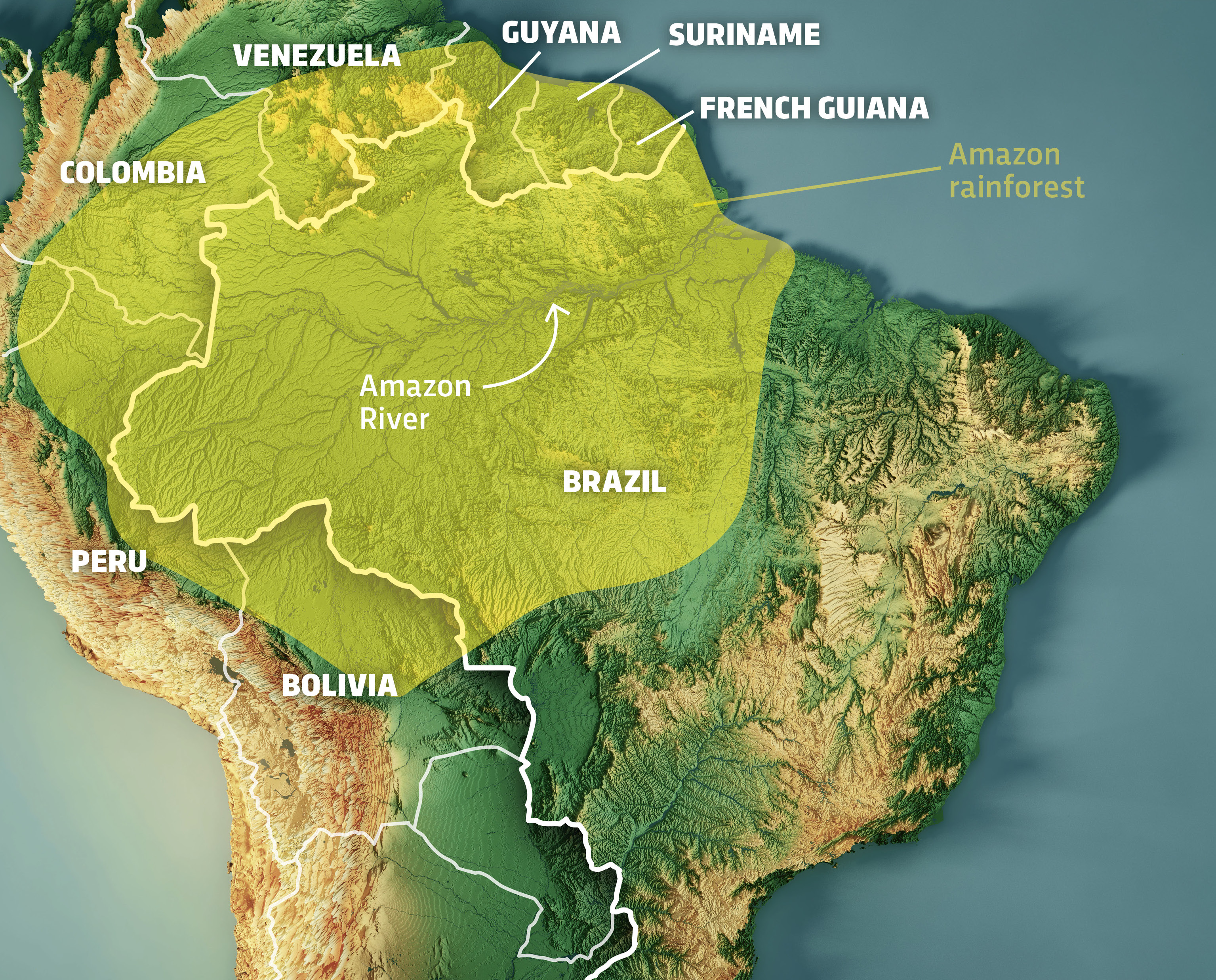
The physical location of the Amazon spans nine nations, primarily Brazil, Peru, and Colombia. However, from a technological perspective, the Amazon is “located” within petabytes of data captured by a growing constellation of Earth-observation satellites. Traditional optical photography is often insufficient for monitoring the rainforest due to the persistent cloud cover that characterizes tropical biomes. This has necessitated a shift toward more advanced sensing technologies.
Optical vs. SAR Imaging: Seeing Through the Clouds
To accurately map the Amazon, tech firms and government agencies utilize Synthetic Aperture Radar (SAR). Unlike optical sensors that rely on sunlight and clear skies, SAR emits its own microwave pulses and measures the reflection back from the ground. This allows tech platforms like those provided by the European Space Agency (ESA) and private firms like ICEYE to “see” through clouds, smoke, and even the darkness of night. This technology provides a 24/7 digital twin of the forest, allowing researchers to pinpoint illegal logging activities in real-time, regardless of weather conditions.
The Role of Landsat and Sentinel in Real-Time Monitoring
The bedrock of Amazonian geospatial data comes from the Landsat program (a joint NASA/USGS initiative) and the Copernicus Sentinel missions. These satellites provide high-resolution imagery that allows for the tracking of “canopy health.” By analyzing the Normalized Difference Vegetation Index (NDVI), software can determine the chlorophyll content of the leaves from hundreds of miles above. This data enables tech-driven conservation groups to identify areas of drought or degradation before they are visible to the naked eye.
Artificial Intelligence and Machine Learning: Locating Deforestation Before It Happens
The sheer volume of data generated by satellites is too vast for human analysts to process. This is where AI and Machine Learning (ML) become the primary tools for identifying the current state and location of the Amazon’s borders. “Where” the forest ends and where cattle ranching begins is a shifting line that AI is uniquely equipped to track.
Neural Networks for Pattern Recognition in Biomes
Modern AI tools use Convolutional Neural Networks (CNNs) to analyze satellite imagery. These models are trained to recognize the distinct patterns of “fishbone” deforestation—a characteristic shape created when illegal roads are cut into the jungle. By automating this detection, tech platforms can alert local authorities within hours of a new road being cleared. This shift from reactive to proactive monitoring is a direct result of advancements in computer vision and deep learning.
Predictive Analytics and Risk Modeling
Tech companies are now moving beyond mere detection into the realm of prediction. By feeding historical data, proximity to existing roads, and economic indicators into ML models, researchers can generate “heat maps” of future deforestation risks. These predictive tools allow for the deployment of resources to the most vulnerable areas of the rainforest, effectively using data science to draw a defensive perimeter around the most critical parts of the ecosystem.
Geographic Information Systems (GIS) and Big Data Integration

If satellites are the eyes and AI is the brain, then Geographic Information Systems (GIS) are the nervous system that organizes our understanding of where the Amazon rainforest is. GIS technology allows for the layering of disparate data sets to create a multi-dimensional view of the region.
Layers of Data: Soil, Hydrology, and Biodiversity
A modern digital map of the Amazon is not just a flat image. It is a stack of data layers. One layer might show soil moisture levels, another shows the migratory paths of indigenous species, and a third shows the legal boundaries of indigenous territories. Software like ArcGIS and QGIS allows scientists to perform complex spatial analysis, such as calculating the “carbon density” of specific forest blocks. This integration of big data is essential for the burgeoning carbon credit market, which relies on precise technological verification of forest preservation.
Open-Source Geospatial Platforms for Global Transparency
The democratization of Amazonian data is a significant tech trend. Platforms like Global Forest Watch (GFW) and Google Earth Engine have made high-end geospatial tools available to the public. These open-source environments allow any user with an internet connection to query “where is the Amazon rainforest disappearing?” and receive an data-driven answer. By hosting these massive datasets in the cloud, tech giants are ensuring that environmental data is transparent and difficult to manipulate for political purposes.
The Connectivity Revolution: Bringing the Internet of Things (IoT) to the Canopy
Determining the exact status of the Amazon also requires “boots on the ground”—or, more accurately, “sensors in the trees.” The integration of the Internet of Things (IoT) into the rainforest is bridging the gap between orbital data and ground-level reality.
Satellite Internet and Low-Earth Orbit (LEO) Solutions
One of the primary historical barriers to monitoring the Amazon was its extreme remoteness. Traditional cellular and fiber-optic networks do not exist in the deep jungle. However, the rise of Low-Earth Orbit (LEO) satellite constellations, such as SpaceX’s Starlink, has revolutionized connectivity in the region. These high-speed, low-latency links allow remote research stations and indigenous communities to upload high-resolution data and video in real-time, effectively bringing the “unmapped” parts of the forest into the global digital network.
Acoustic Monitoring: AI-Powered “Ears” in the Forest
Innovation isn’t limited to visual data. Tech-driven NGOs like Rainforest Connection are installing “Guardian” devices—repurposed smartphones powered by solar panels—high in the forest canopy. These devices use highly sensitive microphones to listen to the forest. AI algorithms on the edge (Edge AI) process the audio locally to identify the specific sound frequency of a chainsaw or a logging truck. Once a match is found, the device sends a real-time alert via satellite to local rangers. This “acoustic forensic” technology provides a layer of protection that visual satellites might miss, particularly under the dense canopy where smaller-scale illegal activity often hides.
The Digital Twin: Simulation and the Future of Amazonian Tech
The ultimate goal of many tech initiatives is the creation of a “Digital Twin” of the Amazon rainforest. A digital twin is a virtual representation that serves as the real-time digital counterpart of a physical object or process.
Climate Modeling and Supercomputing
By utilizing supercomputers, scientists are building complex simulations of the Amazon’s hydrological cycle—the “flying rivers” of water vapor that the forest releases into the atmosphere. These models help tech experts understand how the loss of forest in one specific “where” (e.g., the southeastern Amazon) affects rainfall in distant agricultural regions. These simulations require massive computational power, pushing the limits of current cloud computing architecture and providing invaluable data for global climate change mitigation strategies.
Blockchain for Land Tenure and Traceability
In the realm of digital security and data integrity, blockchain technology is being explored to answer the question of who owns “where” in the Amazon. By recording land titles and environmental permits on a decentralized ledger, the tech community aims to reduce land-grabbing and fraudulent claims. Furthermore, blockchain-based supply chain tools are being used to trace commodities like beef and soy back to their origin, ensuring they were not produced on recently deforested land. This technological “traceability” is becoming a requirement for brands operating in global markets.
In conclusion, “where is the Amazon rainforest” is a question that technology answers with increasing precision every day. We are no longer limited to static borders on a paper map. Through the synergy of satellite constellations, AI-driven analysis, GIS integration, and IoT connectivity, the Amazon is being mapped as a living, breathing digital entity. For the tech industry, the mission is clear: to continue refining the tools that provide the transparency and data necessary to protect this vital global resource. The future of the Amazon is not just in the soil of South America; it is in the servers, sensors, and software that allow us to monitor and understand it in real-time.
aViewFromTheCave is a participant in the Amazon Services LLC Associates Program, an affiliate advertising program designed to provide a means for sites to earn advertising fees by advertising and linking to Amazon.com. Amazon, the Amazon logo, AmazonSupply, and the AmazonSupply logo are trademarks of Amazon.com, Inc. or its affiliates. As an Amazon Associate we earn affiliate commissions from qualifying purchases.