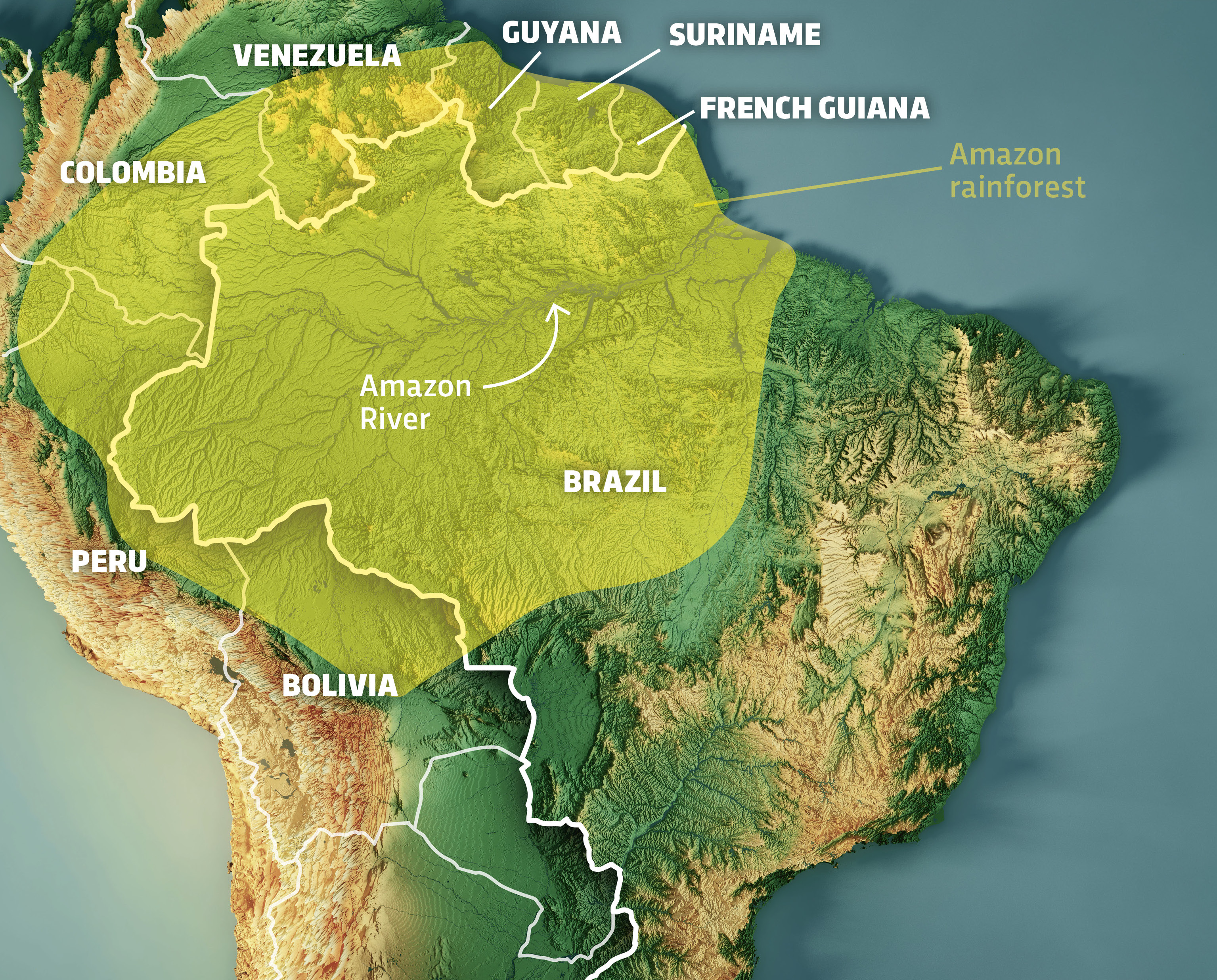
For decades, the question of where the Amazon forest is found was answered by simple physical geography: it spans nine nations in South America, primarily Brazil, Peru, and Colombia. However, in the modern digital era, “finding” the Amazon is no longer a matter of looking at a paper atlas. Today, we locate, define, and monitor the world’s largest rainforest through a sophisticated tech stack comprising satellite constellations, artificial intelligence, and hyperspectral imaging.
As the global climate crisis intensifies, the technology used to map the Amazon has transitioned from passive observation to proactive management. Understanding the precise coordinates of its borders, the density of its canopy, and the rate of its recession requires a synergy of hardware and software that represents the pinnacle of current technological trends.
The Geospatial Revolution: How We Map the Amazon’s Boundaries
Determining exactly where the Amazon forest begins and ends is a dynamic challenge. Because the biome is constantly shifting due to both natural processes and human intervention, static maps are obsolete. The tech industry has stepped in with geospatial tools that provide high-resolution, real-time data.
Satellite Imagery and Remote Sensing
The backbone of locating the Amazon today is remote sensing. Programs like the USGS Landsat and the European Space Agency’s Sentinel-2 provide a continuous stream of optical imagery. These satellites orbit the Earth, capturing data across various electromagnetic spectrums. By analyzing “false-color” imagery—where infrared light is mapped to the visible spectrum—scientists can distinguish between healthy tropical vegetation, degraded forest land, and agricultural encroachment.
The challenge with optical imagery in the Amazon is cloud cover. The rainforest is, by definition, rainy and often obscured. To solve this, “Synthetic Aperture Radar” (SAR) technology has become a game-changer. Unlike optical sensors, SAR emits microwave pulses that penetrate clouds and smoke, allowing tech platforms to “see” where the forest is found even in total darkness or during heavy tropical storms.
LiDAR Technology: Seeing Through the Canopy
While satellites tell us the “where” on a 2D plane, Light Detection and Ranging (LiDAR) tells us the “what” in 3D. LiDAR sensors, often mounted on specialized aircraft or high-altitude drones, pulse laser beams toward the forest floor. By measuring the time it takes for the light to bounce back, the software creates a high-definition “point cloud.”
This technology allows researchers to map the vertical structure of the Amazon. It reveals what lies beneath the upper canopy, identifying old-growth trees versus secondary growth. In the context of “finding” the forest, LiDAR is essential for calculating biomass and carbon storage, turning a visual map into a data-rich repository of environmental intelligence.
AI and Machine Learning: Detecting Real-Time Changes
Having millions of satellite images is useless without the computing power to process them. This is where Artificial Intelligence (AI) and Machine Learning (ML) have revolutionized our understanding of the Amazon’s geography.
Automated Deforestation Alerts
In the past, identifying forest loss required manual comparison of images, a process that could take months. Today, computer vision algorithms are trained to recognize patterns of “fishbone” deforestation—the tell-tale sign of illegal roads being cut into the jungle.
Systems like Global Forest Watch utilize ML models that scan incoming satellite feeds every day. When the software detects a change in pixels that suggests tree cover loss, it automatically triggers an alert. This tech-driven approach answers the question of where the forest is found today versus where it was yesterday, providing actionable data for law enforcement and NGOs to intervene before the damage becomes irreversible.
Predictive Analytics for Conservation
Tech is also being used to predict where the forest will be lost next. By feeding historical data, proximity to roads, and economic trends into neural networks, researchers can create heat maps of future risk. These predictive models allow for “precision conservation.” Instead of monitoring the entire 6.7 million square kilometers of the Amazon basin, resources can be funneled into high-risk zones identified by software, maximizing the impact of limited boots-on-the-ground resources.

The Role of Big Data in Protecting the World’s Lungs
The sheer volume of data generated by monitoring the Amazon is staggering. A single high-resolution pass over the basin can generate terabytes of data. Managing this requires a robust digital infrastructure that bridges the gap between raw data and user-friendly insights.
Open Data Platforms and Global Collaboration
The democratization of technology has played a massive role in Amazonian mapping. Platforms like Google Earth Engine have made planetary-scale geospatial analysis accessible to anyone with an internet connection. By hosting petabytes of satellite data in the cloud, these platforms allow researchers to run complex algorithms without needing a local supercomputer.
This open-tech approach ensures that the answer to “where is the Amazon forest found” is transparent. When data is siloed within government agencies, it can be subject to political manipulation. However, when the data is hosted on global cloud platforms and analyzed by independent tech companies, it creates a “single source of truth” that holds stakeholders accountable.
Cloud Computing Infrastructure for Environmental Monitoring
The move to the cloud has facilitated the integration of multi-source data. We are no longer just looking at pictures; we are layering data. A modern map of the Amazon might include layers of satellite imagery, precipitation data from weather IoT sensors, and socio-economic data regarding land titles.
Processing these layers simultaneously requires the massive parallel processing capabilities of modern cloud architecture. This allows for “near-real-time” monitoring. For example, if a fire breaks out in a remote corner of the Peruvian Amazon, thermal sensors on satellites detect the heat signature, the data is processed in a cloud server, and an alert is sent to a park ranger’s mobile app—all within hours.
Connectivity in the Deep Wild: Sensors and IoT
As we move from the macro-scale of satellites to the micro-scale of the forest floor, the Internet of Things (IoT) is defining the new frontier of Amazonian tech.
Acoustic Monitoring and Bioacoustics
You cannot always see what is happening in the Amazon, but you can always hear it. A growing trend in “Eco-Tech” involves the deployment of solar-powered acoustic sensors—often referred to as “top-of-canopy” IoT devices. These devices use AI to listen for the sounds of chainsaws or trucks.
The “Rainforest Connection” (RFCx) is a prime example of this technology. They repurpose old smartphones into sophisticated listening posts. These devices are hidden in the trees, where they continuously monitor the soundscape. When the AI detects the specific frequency of a chainsaw, it sends an alert via the cellular network. This technology extends the “findability” of the forest into the realm of sound, allowing us to locate illegal activity in real-time.
Future Trends: Blockchain and Traceability
Looking forward, the tech used to locate the Amazon forest is beginning to merge with the tech used to protect its products. Blockchain technology is being explored to create “digital twins” of forest areas. By tokenizing specific plots of land, organizations can create a transparent record of conservation.
Furthermore, blockchain-based supply chain tools are being used to ensure that products like beef, soy, and timber are not sourced from deforested areas. By linking GPS coordinates of where the Amazon forest is found directly to a product’s digital ledger, consumers and companies can verify that their purchases are not contributing to the forest’s disappearance. This represents a shift from simply observing the forest to digitally protecting it through financial and technological transparency.
Conclusion
The question of where the Amazon forest is found has evolved into a complex technological inquiry. It is found in the petabytes of data stored in cloud servers; it is found in the heat signatures captured by infrared satellite sensors; and it is found in the acoustic frequencies analyzed by AI on the forest floor.
As we advance, the integration of these technologies—from orbital satellites to blockchain-verified supply chains—creates a digital shield around the Amazon. The forest is no longer a dark, unmapped wilderness. Through the lens of modern technology, it is a transparent, monitored, and data-rich ecosystem. The survival of the Amazon likely depends on our ability to continue innovating, ensuring that our digital tools can keep pace with the physical challenges facing the world’s most vital forest.
aViewFromTheCave is a participant in the Amazon Services LLC Associates Program, an affiliate advertising program designed to provide a means for sites to earn advertising fees by advertising and linking to Amazon.com. Amazon, the Amazon logo, AmazonSupply, and the AmazonSupply logo are trademarks of Amazon.com, Inc. or its affiliates. As an Amazon Associate we earn affiliate commissions from qualifying purchases.