
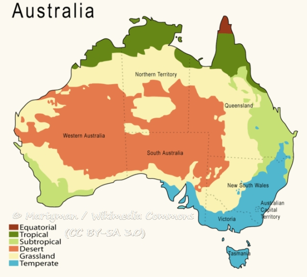
Australia is a continent defined by its meteorological volatility. From the tropical cyclones of the Top End to the blistering heatwaves of the Red Centre and the sudden, torrential “East Coast Lows,” the nation’s climate is as diverse as its geography. However, in the modern era, answering the question of “what weather in Australia” is no longer just about checking a thermometer or looking at a paper map. It has become a sophisticated technological endeavor involving high-performance computing, artificial intelligence, and a sprawling network of Internet of Things (IoT) sensors. For the tech-savvy observer, the story of Australian weather is a story of digital transformation and the relentless pursuit of data-driven precision.
The Digital Backbone: High-Performance Computing and Satellite Integration
At the heart of Australia’s meteorological capability is the Bureau of Meteorology (BoM), an organization that has transitioned from traditional observation to a data-centric powerhouse. The cornerstone of this infrastructure is “Australis,” one of the most powerful supercomputers in the Southern Hemisphere. This high-performance computing (HPC) cluster allows meteorologists to run complex Numerical Weather Prediction (NWP) models that simulate the atmosphere’s behavior with unprecedented granularity.
The Power of Australis and Global Modeling
The shift from 12-kilometer resolution grids to 1.5-kilometer grids has revolutionized how Australia predicts localized events. In the past, a thunderstorm over the Blue Mountains might have been missed by broader models; today, the sheer processing power of modern HPCs allows for the simulation of convective processes that drive such storms. These models integrate billions of data points—from atmospheric pressure to sea surface temperatures—to provide a four-dimensional view of the continent’s weather patterns. This isn’t just about knowing if it will rain; it’s about calculating the exact millimetric intensity and its impact on urban drainage systems and rural catchment areas.
Himawari-8 and the Era of Real-Time Satellite Imaging
Complementing the ground-based computing is the data stream from the Himawari-8 satellite. This geostationary satellite provides high-resolution imagery every ten minutes, capturing the Australian landmass in multiple spectral bands. This tech stack allows for the tracking of smoke plumes from bushfires, the development of tropical cyclones in the Arafura Sea, and even the movement of dust storms across the Nullarbor. The integration of this satellite data into software platforms allows emergency services to visualize weather threats in real-time, moving beyond static forecasts to dynamic, visual intelligence.
AI and Machine Learning: Predicting the Unpredictable
While traditional physics-based models are the foundation, the integration of Artificial Intelligence (AI) and Machine Learning (ML) is the new frontier in understanding Australian weather. These technologies are particularly adept at identifying patterns in “noisy” data that human analysts or rigid algorithms might overlook.
Transforming Bushfire Modeling with Generative AI
In Australia, weather and fire are inextricably linked. The concept of “fire weather”—where extreme heat, low humidity, and high winds create catastrophic conditions—is now being modeled using generative AI. By feeding decades of historical weather data and fire behavior into neural networks, researchers can predict how a fire might create its own weather systems, such as pyrocumulonimbus (fire-induced thunderstorms). These AI tools can run thousands of “what-if” scenarios in seconds, providing fire crews with a probabilistic map of where a blaze might jump containment lines based on micro-climatic shifts.
Deep Learning for Flash Flood Forecasting
Flash flooding is another area where AI is outperforming traditional tech. In urban environments like Brisbane or Sydney, the “what weather” question often centers on whether a sudden downpour will lead to inundated streets. Deep learning models are now being trained on radar data to recognize the “signatures” of slow-moving, high-intensity storm cells. By identifying these patterns earlier than traditional radar analysis, AI software provides an extra 15 to 30 minutes of lead time—a critical window for activating automated flood barriers and sending geo-targeted mobile alerts to residents.
The Proliferation of IoT and Hyper-Local Weather Data

The democratization of weather technology has moved the focus from national bureaus to the palms of individual citizens and the fields of smart farms. The Internet of Things (IoT) has facilitated a transition toward hyper-local weather tracking, filling the gaps between government-operated stations.
Smart Agriculture and Precision Weather Gadgets
In the vast Australian outback, a weather station 50 kilometers away is often irrelevant to a farmer’s specific micro-climate. Modern AgTech (Agricultural Technology) solutions now involve the deployment of on-site IoT sensors that measure soil moisture, leaf wetness, and localized wind speed. These devices sync via LoRaWAN or satellite links (like Starlink) to cloud-based dashboards. This allows for “precision weather” management, where automated irrigation systems trigger only when local evaporation rates hit a certain threshold, and drone-based crop spraying is scheduled for the exact moment wind speeds are lowest.
The Rise of Consumer Weather Apps and Software Ecosystems
For the average Australian, “what weather” is answered through a sophisticated app ecosystem. Apps like WillyWeather and the BoM Weather app have moved beyond simple icons. They now offer augmented reality (AR) overlays of rain radars and integration with smart home devices. Imagine a tech-integrated home where the smart blinds automatically close when the local station detects a spike in UV radiation or the smart garage door shuts because a hail-producing storm cell is detected within a 5-kilometer radius. This level of software integration is turning weather data into actionable home automation triggers.
Digital Security and Resilience in Meteorological Infrastructure
As weather data becomes more critical to Australia’s economy and safety, the digital security of this information has become a paramount concern. The infrastructure that tells us “what weather in Australia” is now classified as critical national infrastructure, making it a target for cyber threats and requiring robust digital defenses.
Protecting Critical Infrastructure from Cyber Threats
The sensors, satellites, and supercomputers that track Australian weather are part of a massive, interconnected network. A disruption to this data flow—whether through a DDoS attack on the Bureau’s servers or a sophisticated intrusion into emergency broadcast systems—could have catastrophic consequences. Consequently, there is a heavy investment in digital security protocols, including encrypted data transmission from remote weather stations and multi-layer authentication for accessing meteorological modeling software. The resilience of the Australian weather tech stack is as much about cybersecurity as it is about atmospheric science.
The Role of Cloud Computing in Disaster Response
During extreme weather events, the demand for weather data spikes exponentially. Traditional server architectures often struggle under the weight of millions of simultaneous requests. To combat this, the shift to cloud-native architectures allows weather services to “burst” their capacity. By utilizing cloud providers, weather platforms can scale their resources in real-time, ensuring that when a cyclone is making landfall, the public-facing apps and APIs remain responsive. This elasticity is a cornerstone of modern digital disaster management, ensuring that life-saving information is never throttled by server limitations.

The Future: Quantum Computing and the Next Leap Forward
Looking ahead, the next evolution in answering “what weather in Australia” lies in the realm of quantum computing. The atmosphere is a chaotic system where small changes can lead to vastly different outcomes—the proverbial “butterfly effect.” Current binary computers, powerful as they are, still struggle with the infinite variables of atmospheric fluid dynamics.
Quantum algorithms, however, are uniquely suited to solving these types of multi-variable optimization problems. In the coming decade, we can expect to see quantum-enhanced models that can predict the onset of El Niño or La Niña cycles with near-perfect accuracy months in advance. For the Australian tech sector, this represents a massive opportunity to lead the world in climate-adaptation technology. From AI-driven bushfire simulations to IoT-enabled smart cities, the technology behind Australian weather is not just about observation; it is about creating a digital shield against one of the most challenging environments on Earth.
As we continue to refine these tools, the answer to “what weather in Australia” will increasingly be found not in the clouds, but in the code, the silicon, and the sophisticated algorithms that map our changing world.
aViewFromTheCave is a participant in the Amazon Services LLC Associates Program, an affiliate advertising program designed to provide a means for sites to earn advertising fees by advertising and linking to Amazon.com. Amazon, the Amazon logo, AmazonSupply, and the AmazonSupply logo are trademarks of Amazon.com, Inc. or its affiliates. As an Amazon Associate we earn affiliate commissions from qualifying purchases.