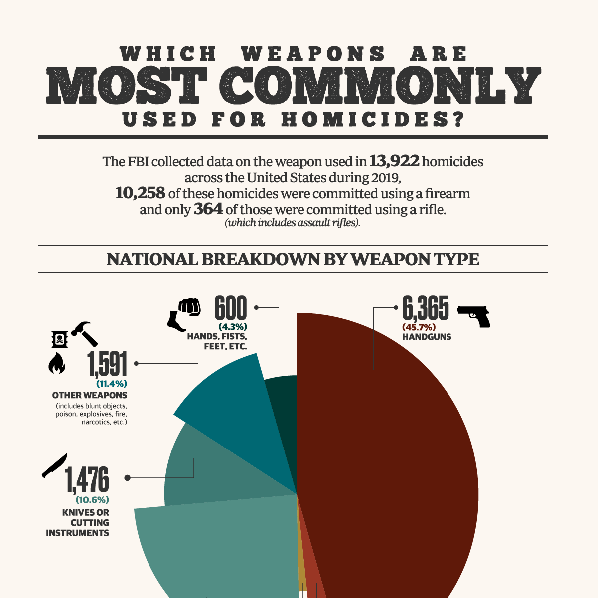
In the discourse of natural disasters, the public imagination is often captured by the cinematic destruction of tornadoes or the cinematic scale of hurricanes. However, when examining the data regarding which weather phenomenon kills the most people, the answer is often surprising: extreme heat. Traditionally, the human race was at the mercy of these atmospheric shifts. Today, the intersection of meteorology and advanced technology has shifted the paradigm. We are no longer passive observers; we are utilizing high-performance computing, artificial intelligence, and sophisticated sensor networks to mitigate the lethality of our changing climate.

This article explores the technological landscape designed to combat the world’s deadliest weather events, focusing on the software, hardware, and digital frameworks that are saving lives on a global scale.
The Silent Killer: Extreme Heat and the Evolution of Thermal Monitoring Tech
Statistically, extreme heat remains the deadliest weather-related phenomenon in many developed nations, including the United States. Unlike a flood or a storm, heat is a “silent killer” that leaves no debris path but puts immense strain on the human cardiovascular system. Technology has become the primary tool in identifying and mitigating these invisible heat waves.
IoT and Urban Heat Island Mapping
Internet of Things (IoT) sensors are now being deployed across major metropolises to map “Urban Heat Islands”—areas where concrete and lack of vegetation cause temperatures to soar significantly higher than in surrounding rural areas. These sensor networks provide real-time data to municipal dashboards, allowing city planners to identify high-risk zones. By using this tech-driven data, cities can deploy mobile cooling stations or trigger emergency “coolth” protocols specifically in the neighborhoods that need them most.
Predictive Analytics in Public Health Technology
Modern software platforms now integrate meteorological data with public health databases. Using predictive analytics, health departments can forecast spikes in heat-related hospitalizations days before a heatwave peaks. These algorithms analyze historical mortality data against projected humidity levels and nighttime lows (which are critical for human recovery). This allows for the automated distribution of alerts to vulnerable populations, such as the elderly or those with pre-existing conditions, via specialized health apps and SMS gateways.
Wearable Tech and Workforce Safety
In the industrial and construction sectors, wearable technology is being used to prevent heatstroke among outdoor workers. Smart vests and wristbands equipped with biometric sensors monitor core body temperature and heart rate variability. When the data indicates a worker is entering a high-risk zone for heat exhaustion, the device sends a haptic alert to the wearer and a notification to a central safety dashboard, mandating an immediate break.
Forecasting the Surge: Digital Innovations in Flooding and Hurricane Prediction
Flooding, often triggered by tropical cyclones or extreme rainfall, ranks as the second most lethal weather phenomenon globally. The technological challenge here is twofold: predicting the path of the water and ensuring that information reaches people in time to evacuate.
Advanced Hydrological Modeling Software
The transition from 2D to 3D hydrological modeling has revolutionized flood preparation. Software such as HEC-RAS (Hydrologic Engineering Center’s River Analysis System) now utilizes Lidar (Light Detection and Ranging) data to create highly accurate digital elevation models. These simulations can predict exactly which streets will be underwater given a specific amount of rainfall. For emergency managers, this software is the difference between a general evacuation order and a targeted, efficient operation that saves lives and resources.
Satellite Imagery and Real-Time Data Streams
The deployment of Next-Generation Satellites, such as the GOES-R series, provides high-resolution imagery with a frequency that was previously impossible. These satellites act as our “eyes in the sky,” tracking the convective pulses of developing storms. By feeding this real-time data into cloud-based processing units, meteorologists can detect the rapid intensification of hurricanes—a phenomenon that has historically been difficult to predict and highly lethal.
Digital Security and Emergency Communication
In the event of a catastrophic storm, digital security and communication integrity are paramount. Mesh networking technology—which allows devices to communicate directly with one another without relying on centralized cell towers—has become a vital tool for disaster response. When the primary infrastructure fails, these tech-driven decentralized networks ensure that emergency alerts and SOS signals can still move through the affected area.
Artificial Intelligence and the Future of Early Warning Systems
The most significant leap in reducing weather-related mortality is the integration of Artificial Intelligence (AI) and Machine Learning (ML). Traditional forecasting relies on “Numerical Weather Prediction” (NWP), which uses complex physics equations that require massive supercomputing power and significant time to run. AI is changing the speed of this equation.
Machine Learning in Meteorological Pattern Recognition
AI models, such as Google’s GraphCast or NVIDIA’s FourCastNet, are trained on decades of historical weather data. Unlike traditional models, these AI systems can recognize patterns and predict the trajectory of deadly storms in seconds rather than hours. This “lead time” is the most critical metric in saving lives. If a community has an extra six hours of warning for a flash flood or a tornado, the mortality rate drops exponentially.
The Role of Edge Computing in Disaster Response
While central AI models handle global forecasts, “Edge Computing” handles local data. Sensors located on bridges, dams, and in forests process data locally before sending it to the cloud. In the case of a sudden weather event, like a “dry lightning” storm that could trigger wildfires, edge devices can trigger local sirens and alerts instantly. This eliminates the latency of sending data to a distant server and waiting for a response, providing those vital seconds needed to seek shelter.
Neural Networks for Hyper-Local Forecasting
One of the greatest killers is the “micro-burst” or the “flash flood”—events that are too small for global models to catch. Neural networks are now being applied to “Nowcasting,” which focuses on the 0–6 hour window. By analyzing local radar data and atmospheric pressure changes, these AI tools can provide hyper-local warnings that are specific to a single zip code or even a single street, preventing people from being caught unaware by localized lethal weather.
Building Resilience through Structural and Digital Integration
The final frontier in using technology to combat lethal weather is the concept of “Smart Resilience.” This involves integrating digital intelligence directly into our physical world to ensure that when the deadliest weather strikes, our infrastructure can react autonomously.
Smart Infrastructure and Sensor Networks
Modern civil engineering now incorporates “smart” materials and sensors into bridges and skyscrapers. These sensors monitor structural integrity during high-wind events like tornadoes or hurricanes. If the software detects stress levels that exceed safety thresholds, it can automatically trigger the closure of transit routes or the lockdown of buildings. This automated digital oversight removes the element of human error from the safety equation.
Blockchain for Transparent Disaster Recovery Data
While recovery happens after the event, the efficiency of that recovery dictates the long-term mortality rate associated with displacement and disease. Blockchain technology is being explored as a method to manage disaster relief funds and supply chains. By using a decentralized ledger, NGOs and governments can ensure that life-saving resources—water, medicine, and food—are tracked and delivered to the most affected areas without the risk of data tampering or bureaucratic bottlenecks.
Digital Twins for Urban Simulation
A “Digital Twin” is a virtual replica of a physical city. Urban planners use these digital environments to simulate the most lethal weather scenarios—such as a 1-in-500-year flood or a month-long heatwave. By running these simulations in a digital space, technologists can identify “points of failure” in a city’s design. They can then implement tech-driven solutions, such as automated floodgates or smart grid rerouting, before the actual weather event occurs.
Conclusion: The Digital Shield Against the Elements
While extreme heat, floods, and storms continue to be the deadliest weather phenomena on Earth, the “tech-gap” between human vulnerability and atmospheric violence is closing. We are moving toward a future where “unpredictable” weather is a thing of the past. Through the power of AI-driven forecasting, IoT monitoring, and smart infrastructure, we are building a digital shield that protects the global population.
The data is clear: weather kills, but technology saves. As we continue to refine our software, enhance our hardware, and secure our digital communications, we are not just predicting the weather—we are engineering a world where the deadliest phenomena no longer have the power to claim lives on a massive scale. The investment in “Weather Tech” is not just an investment in gadgets or apps; it is a fundamental investment in the preservation of human life in an era of climatic uncertainty.
aViewFromTheCave is a participant in the Amazon Services LLC Associates Program, an affiliate advertising program designed to provide a means for sites to earn advertising fees by advertising and linking to Amazon.com. Amazon, the Amazon logo, AmazonSupply, and the AmazonSupply logo are trademarks of Amazon.com, Inc. or its affiliates. As an Amazon Associate we earn affiliate commissions from qualifying purchases.