The quest to identify the “strongest hurricane ever recorded” is less about a single definitive event and more about a testament to the astounding advancements in meteorological technology and data science. Our ability to measure, track, and analyze these colossal atmospheric engines has evolved dramatically, transforming from rudimentary observations to sophisticated, satellite-driven, AI-enhanced systems. This evolution directly influences what we consider “recorded” and how accurately we can quantify extreme events.
The Technological Quest for the “Strongest”: A Historical Perspective
The concept of “strength” in a hurricane is primarily defined by its lowest central atmospheric pressure and maximum sustained wind speeds. Historically, recording these parameters was a formidable challenge, relying on limited tools and often hazardous direct observations. The very definition of “recorded” has undergone a profound technological transformation.

Early Instrumentation and Analog Data Capture
Before the advent of modern digital and remote sensing technologies, meteorologists relied on basic, yet critical, instruments. Barometers provided essential central pressure readings, often from land-based stations or courageous ship crews who found themselves in the path of a storm. Anemometers, though less common in the open ocean, offered localized wind speed data. These early records, while invaluable, suffered from significant limitations: spatial sparsity, temporal discontinuity, and inherent inaccuracies. A ship caught in the eye of a monster storm might provide an astonishingly low pressure reading, but it was an isolated point of data, providing little context about the storm’s overall structure or sustained intensity. This analog era laid the groundwork but painted an incomplete picture, making a definitive “strongest” challenging to ascertain with high confidence.
Aerial Reconnaissance and Doppler Radar Revolution
The mid-20th century brought a significant leap with the introduction of aerial reconnaissance. Aircraft, specifically designed or modified for “hurricane hunting,” began flying directly into the eye of storms. Equipped with advanced barometers, thermometers, and later, dropsondes (disposable instruments parachuted into the storm to transmit atmospheric data), these flights provided unprecedented direct measurements of central pressure and wind profiles. This direct, in-situ data was a game-changer for validating satellite observations and refining intensity estimates.
Complementing aerial reconnaissance was the widespread deployment of Doppler radar systems. While primarily land-based, these systems offered detailed insights into storm structure, rainfall rates, and localized wind shear. The Doppler effect, utilized by these radars, allowed meteorologists to measure the velocity of precipitation within a storm, indirectly inferring wind speeds and rotation. This marked a crucial step towards understanding the internal dynamics of hurricanes in a continuous, near real-time manner, allowing for more robust data collection for intensity estimation and forecasting.
Satellite Surveillance and Advanced Remote Sensing
The true revolution in hurricane monitoring arrived with the space age. Satellites transformed our understanding and recording capabilities, offering continuous, wide-area surveillance that no ground-based or aerial system could match.
Geostationary and Polar-Orbiting Satellites: The Eyes in the Sky
Geostationary satellites, positioned to remain over a fixed point on Earth, provide continuous imagery of weather systems, including hurricane development and movement. Their rapid refresh rates (often every 5-15 minutes) allow for near real-time tracking of cloud patterns, eye formation, and intensity changes. Techniques like the Dvorak technique, which uses visible and infrared satellite imagery to estimate storm intensity, became standard tools, though they rely on skilled human interpretation.
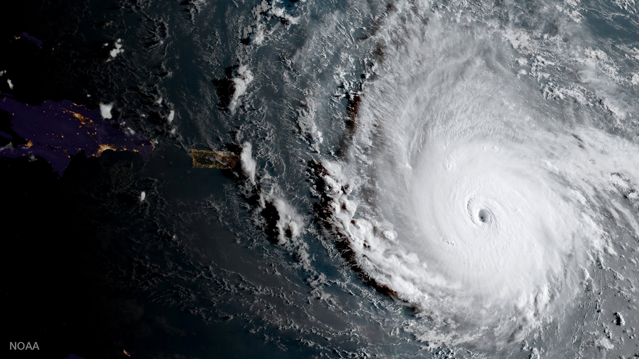
Polar-orbiting satellites, traversing the globe from pole to pole, offer higher resolution data and a different perspective. Equipped with passive microwave sensors, these satellites can peer through cloud tops to reveal the internal structure of a storm, including the presence and intensity of eyewall convection – a critical indicator of strength. By combining data from both types of satellites, meteorologists can create a much more comprehensive, three-dimensional view of a hurricane’s evolution. This fusion of data streams provides the robust evidence necessary to categorize and compare storms with unprecedented accuracy, leading to more definitive “strongest recorded” declarations. For instance, the rapid intensification of Hurricane Wilma (2005) to a central pressure of 882 mb—one of the lowest ever recorded in the Atlantic—was meticulously tracked and confirmed through a combination of satellite imagery and direct reconnaissance flights, highlighting the synergy of these technologies.
AI and Machine Learning in Image Analysis for Intensity Estimation
The sheer volume of data generated by satellite constellations has led to the integration of Artificial Intelligence (AI) and Machine Learning (ML) into hurricane analysis. Traditional Dvorak analysis, while effective, is subjective and labor-intensive. AI models, trained on vast datasets of historical satellite imagery paired with confirmed intensity measurements (from aircraft or buoys), can now automate and enhance the Dvorak technique. These algorithms can identify subtle patterns in cloud top temperatures, eye morphology, and spiral banding that human analysts might miss, providing more objective and consistent intensity estimates.
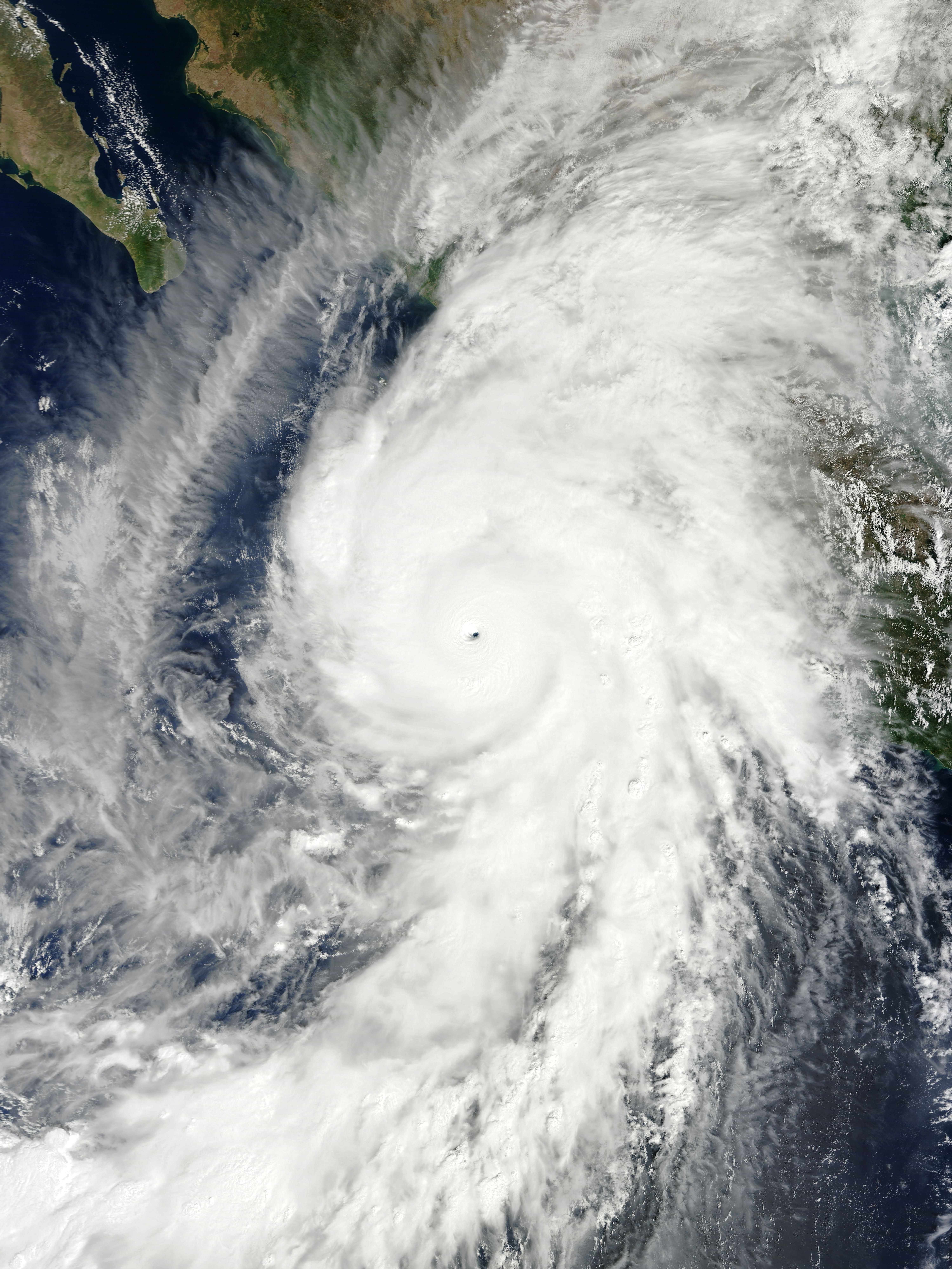
Furthermore, deep learning models are being developed to directly estimate maximum sustained winds and central pressure from satellite imagery without relying on intermediate steps. By processing multi-spectral satellite data, AI can detect features indicative of rapid intensification or weakening, allowing for quicker and more accurate updates to storm forecasts and intensity warnings. The precision afforded by these intelligent systems is continually refining our understanding of what constitutes “strongest,” enabling us to better benchmark historical and future events. For example, the incredibly low pressure of Typhoon Tip (1979) at 870 mb, or Hurricane Patricia (2015) in the Eastern Pacific at 872 mb, were validated through a combination of direct measurements (Tip) and the most advanced satellite and modeling techniques available at the time (Patricia), which continue to be refined by AI today.
Data Analytics and Predictive Modeling for Extreme Events
Beyond merely recording, modern technology allows us to anticipate and understand the complex dynamics that lead to a “strongest” hurricane. Data analytics and supercomputing power are at the heart of this predictive capability.
Supercomputing and Ensemble Forecasting Models
Forecasting the path and intensity of hurricanes requires immense computational power. Supercomputers run complex atmospheric models that simulate the physics of the atmosphere and oceans. These models ingest vast quantities of real-time data from satellites, buoys, radar, and weather stations globally. A significant leap in forecasting accuracy has come from “ensemble forecasting,” where the same model is run multiple times with slightly varied initial conditions. This produces a range of possible outcomes, giving forecasters a probabilistic view of a storm’s future track and intensity, including the likelihood of it reaching extreme strength. The ability to run these computationally intensive ensembles quickly provides critical lead time for preparedness, which is paramount when dealing with potentially record-breaking storms.
Real-time Data Streams and Decision Support Systems
The aggregation and analysis of real-time data streams are crucial for dynamic decision-making during a hurricane event. Geographic Information Systems (GIS) integrate meteorological data with demographic information, infrastructure maps, and evacuation routes, providing a visual and analytical platform for emergency managers. Cloud-based platforms facilitate the rapid sharing of this critical data among various agencies and the public. These digital decision support systems, fed by constantly updated meteorological models and observations, enable authorities to issue precise warnings, coordinate evacuations, and deploy resources efficiently. The effectiveness of these systems in mitigating the impact of an approaching “strongest” storm hinges directly on the speed and accuracy of the underlying technological infrastructure, from data collection to final dissemination.
The Digital Nexus of Resilience: From Observation to Action
The journey from detecting a burgeoning tropical depression to understanding and preparing for a potentially record-breaking hurricane is intrinsically linked to a robust digital infrastructure.
Cloud Computing and Global Data Sharing for Climate Science
The scale of data involved in climate science and extreme weather analysis necessitates advanced computing paradigms. Cloud computing provides the flexible, scalable infrastructure required to store, process, and analyze petabytes of meteorological data. This shared infrastructure also facilitates global collaboration among researchers. Scientists from different continents can access and jointly analyze the same comprehensive datasets, fostering a collective understanding of global weather patterns and the factors that contribute to the intensification of hurricanes. This global digital commons accelerates research into climate change impacts on hurricane frequency and intensity, helping refine our long-term strategies for resilience in the face of increasingly powerful storms.
Open-Source Platforms and Community Engagement in Disaster Tech
Technological innovation in disaster preparedness extends beyond government agencies and research institutions. The open-source community plays a vital role, developing tools for data visualization, real-time mapping, and citizen science initiatives. Platforms that allow individuals to report observations, share damage assessments, or access critical information through mobile applications significantly enhance situational awareness. These digital tools empower communities, making them active participants in disaster response and recovery. From crowdfunding platforms for immediate relief to sophisticated apps that guide individuals through evacuation procedures, technology democratizes access to information and fosters collective action. This blend of cutting-edge scientific instrumentation, AI-driven analysis, supercomputing power, and community-driven digital tools continually refines our definition of “strongest recorded” and strengthens our capacity to confront these formidable natural phenomena.
aViewFromTheCave is a participant in the Amazon Services LLC Associates Program, an affiliate advertising program designed to provide a means for sites to earn advertising fees by advertising and linking to Amazon.com. Amazon, the Amazon logo, AmazonSupply, and the AmazonSupply logo are trademarks of Amazon.com, Inc. or its affiliates. As an Amazon Associate we earn affiliate commissions from qualifying purchases.