
In the modern digital landscape, the question “What ward am I in DC?” is no longer answered by unfolding a tattered paper map or visiting a municipal office. Instead, it is solved through a sophisticated interplay of Geographic Information Systems (GIS), cloud-based data repositories, and high-speed API integrations. For residents of the District of Columbia, identifying their ward is the gateway to local civic participation, and for the tech community, it represents a masterclass in how smart city infrastructure delivers hyper-local data to the end-user.
This article explores the technological framework that powers the “Find My Ward” services in Washington, D.C., examining the software, data security protocols, and geospatial tools that make urban navigation possible in the digital age.
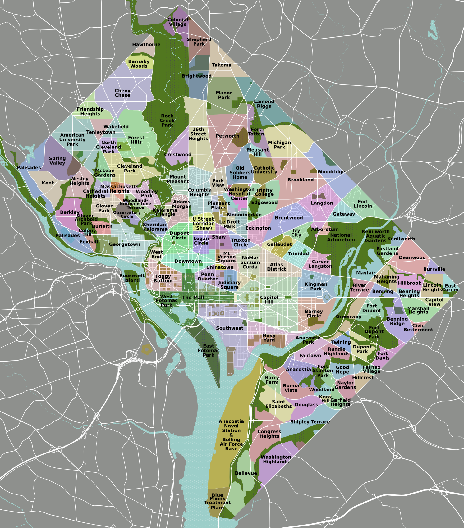
The Intersection of Geospatial Technology and Local Governance
At the heart of any location-based query lies Geographic Information Systems (GIS). In Washington, D.C., the Office of the Chief Technology Officer (OCTO) manages a robust GIS program that serves as the backbone for nearly all spatial data in the city. When a user enters an address to find their ward, they are interacting with a complex database where every square inch of the District is digitized and categorized.
Understanding GIS (Geographic Information Systems)
GIS is more than just a digital map; it is a framework for gathering, managing, and analyzing data. It roots data in geography, integrating various layers of information—such as ward boundaries, precinct lines, and property lots—using spatial location. For D.C., the GIS infrastructure utilizes vector data (points, lines, and polygons) to define the specific shapes of the eight wards.
When you search for your ward, the software performs a “point-in-polygon” analysis. The system converts your street address into a set of coordinates (latitude and longitude) and then checks which ward polygon those coordinates fall within. This process, known as geocoding, happens in milliseconds, showcasing the efficiency of modern spatial databases like Esri’s ArcGIS or open-source alternatives like PostGIS.
The Role of Open Data Portals in Urban Management
The District of Columbia is a pioneer in the “Open Data” movement. Through the Open Data DC portal, the government provides public access to the same datasets used by city officials. This transparency is powered by specialized software that allows developers and residents to download shapefiles or connect to live GeoJSON feeds.
By making ward boundary data public, the city enables a decentralized ecosystem of apps. Developers can pull this data into their own software, allowing real-time updates whenever boundaries shift due to redistricting. This “Data-as-a-Service” (DaaS) model ensures that whether you are checking your ward on a government site or a third-party neighborhood app, the information remains consistent and authoritative.
Essential Digital Tools for Locating Your Ward
The user experience of finding a ward in D.C. is defined by the tools designed to bridge the gap between complex municipal data and the average citizen. These tools range from simple search bars to comprehensive interactive mapping suites that offer a 360-degree view of local jurisdiction.
The DC Government’s Interactive Mapping Suite
The most direct way to answer “What ward am I in DC?” is through the District’s specialized web applications. These apps are built using responsive web design principles, ensuring that a resident can find their ward as easily on a smartphone as they can on a desktop.
The primary tool utilized is the “Master Address Repository” (MAR). The MAR is a high-performance database designed to resolve the common issues associated with urban addresses, such as abbreviations, unit numbers, and historical street names. When a user types into a “Find Your Ward” search box, the MAR provides “type-ahead” suggestions, using predictive algorithms to ensure the user selects a valid, geocoded address. This reduces user error and ensures that the resulting ward identification is 100% accurate based on current legal boundaries.
Third-Party API Integrations and Civic Apps
Beyond official government sites, the tech community leverages APIs (Application Programming Interfaces) to integrate ward data into broader software solutions. For example, real estate platforms, voting advocacy apps, and local news sites often embed “Ward Finder” widgets.

These integrations typically rely on RESTful APIs. When a user interacts with a third-party app, the app sends a request to a D.C. government server, which processes the location data and returns a JSON response containing the ward number, the name of the Councilmember, and even the local Advisory Neighborhood Commission (ANC) details. This modularity is a hallmark of modern software architecture, allowing hyper-local information to be ubiquitous across the digital landscape.
The Evolution of Digital Boundary Mapping
The precision we see today in digital mapping is a relatively recent achievement. The transition from physical record-keeping to a real-time, cloud-synced digital environment has fundamentally changed how the District manages its internal borders.
From Paper Maps to Real-Time Updates
Historically, ward boundaries were printed on physical maps that became obsolete the moment a new census was conducted or a street was renamed. Today, the D.C. government uses a “digital first” approach to redistricting. Following the decennial census, boundary changes are drawn directly into GIS software.
Once these boundaries are legally approved, the updates are pushed to the cloud. This means that “What ward am I in?” is a question that can be answered accurately even during transitional periods. The use of version-controlled databases ensures that historical data is preserved while the “live” environment reflects the current legal reality. This agility is crucial for administrative functions like voter registration, school lotteries, and trash collection schedules, all of which are ward-dependent.
Ensuring Data Accuracy and Security
With the digitization of address and boundary data comes the need for rigorous digital security and data integrity. The OCTO must ensure that the “authoritative source” of ward data is protected from unauthorized changes.
Technologically, this involves multi-factor authentication for database administrators and the use of encrypted connections (HTTPS) for all public-facing map services. Furthermore, data integrity is maintained through automated validation scripts. These scripts run periodically to ensure that there are no “gaps” or “overlaps” in the ward polygons—topological errors that could result in an address being assigned to two wards or none at all. In a tech-driven city, the accuracy of a polygon is just as important as the security of the server it sits on.
How Technology Shapes Civic Engagement in the District
The ultimate goal of providing tech-driven ward information is to foster a more connected and engaged citizenry. By lowering the barrier to entry for finding local information, the District uses technology as a tool for democratic empowerment.
Personalized Digital Services Based on Location
Once a user identifies their ward via digital tools, the “tech stack” of civic engagement expands. Modern CRM (Customer Relationship Management) systems used by the city can now provide personalized notifications. If you know you are in Ward 6, you can opt into SMS alerts for Ward 6 community meetings or emergency alerts specific to your geographic area.
This level of personalization is made possible by the “Spatial Join” capability of modern databases. By joining a user’s contact information with their ward’s spatial data, the city can move away from “blast” communications toward a more targeted, efficient information delivery system. This reduces digital noise and ensures that the information residents receive is relevant to their specific physical location.
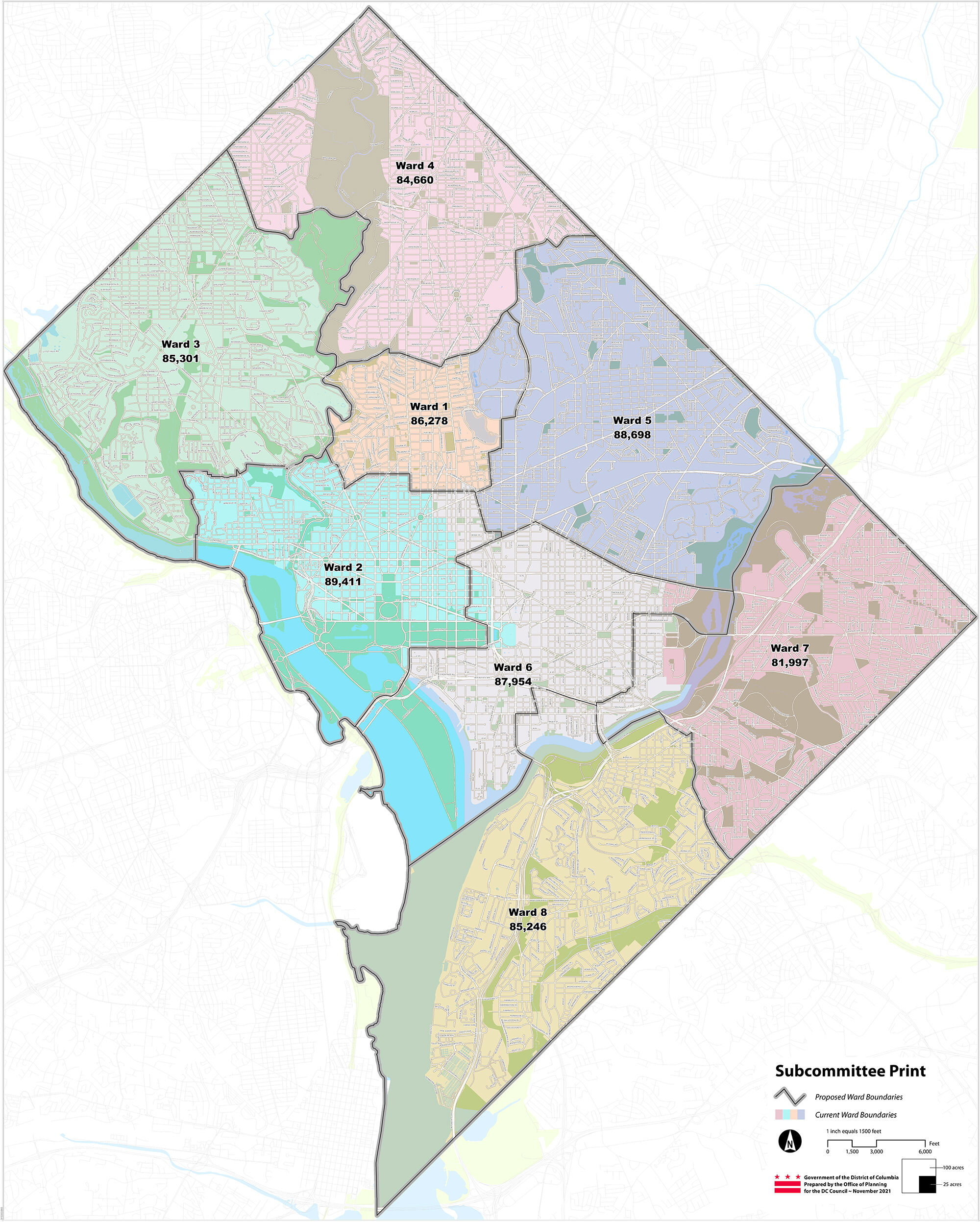
The Future of Smart Cities and Hyper-Local Information
Looking forward, the technology used to identify wards in D.C. will likely integrate with broader “Smart City” initiatives. We are moving toward an era where Internet of Things (IoT) sensors and Augmented Reality (AR) could play a role. Imagine pointing a smartphone camera down a street and seeing a digital overlay that indicates exactly where Ward 1 ends and Ward 2 begins.
Furthermore, as AI and machine learning become more integrated into urban planning, the data gathered from “Ward Finder” tools can help the city understand which areas have the highest demand for services. While individual privacy is protected through data anonymization, the aggregate “heat maps” of where people are searching from can inform where the city might need to deploy more digital kiosks or improve infrastructure.
In conclusion, the question “What ward am I in DC?” serves as a simple entry point into a sophisticated world of geospatial technology and digital governance. Through the use of GIS, robust APIs, and open data initiatives, Washington, D.C. has transformed a bureaucratic necessity into a seamless digital experience. As software continues to evolve, the bridge between the physical streets of the District and the digital maps we use to navigate them will only become more integrated, making civic participation more accessible for every resident.
aViewFromTheCave is a participant in the Amazon Services LLC Associates Program, an affiliate advertising program designed to provide a means for sites to earn advertising fees by advertising and linking to Amazon.com. Amazon, the Amazon logo, AmazonSupply, and the AmazonSupply logo are trademarks of Amazon.com, Inc. or its affiliates. As an Amazon Associate we earn affiliate commissions from qualifying purchases.