
In the realm of geological classification, the Yellowstone volcano is often categorized as a “rhyolitic caldera” or, more colloquially, a “supervolcano.” However, in the 21st century, understanding what type of volcano Yellowstone is requires more than just a geological definition; it requires an exploration of the massive technological infrastructure that monitors its every pulse. From satellite-based Interferometric Synthetic Aperture Radar (InSAR) to deep-earth seismic tomography powered by artificial intelligence, Yellowstone is no longer just a hole in the ground—it is a data-driven laboratory.
Defining the Yellowstone volcano today involves synthesizing petabytes of data to understand its subterranean architecture. By leveraging cutting-edge software and hardware, volcanologists are moving beyond static descriptions and into a dynamic, tech-first era of predictive modeling.

1. Defining the Supervolcano Through the Lens of Modern Geospatial Tech
To answer “what type of volcano” Yellowstone is, we must first look at its footprint. Unlike the conical peaks of Mount St. Helens or Fuji, Yellowstone is a massive depression in the earth. Identifying this “caldera” type requires sophisticated geospatial mapping tools that can see through dense forests and geothermal steam.
The Caldera System: High-Resolution LiDAR Mapping
Yellowstone is primarily a collapse caldera, formed when massive eruptions emptied its magma chambers, causing the ground above to sink. To map these features, scientists utilize LiDAR (Light Detection and Ranging). By firing millions of laser pulses from aircraft, researchers generate high-resolution 3D maps of the terrain. This tech allows geologists to identify subtle fault lines and previous lava flow boundaries that are invisible to the naked eye. Through LiDAR, we have identified that Yellowstone is not a single entity but a series of overlapping calderas, a structural complexity that defines its behavior.
Resurgent Domes and InSAR Technology
One of the key characteristics of a “restless” caldera is the presence of resurgent domes—areas where the ground actually rises and falls like a breathing chest. To monitor this, scientists employ InSAR. This satellite technology compares radar signals from different points in time to measure ground deformation with millimeter-precision. In the tech-heavy world of volcanology, InSAR has proven that Yellowstone is a dynamic system, with the Sour Creek and Mallard Lake domes constantly shifting due to the movement of hydrothermal fluids and magma miles below the surface.
2. The Internet of Things (IoT) and the Yellowstone Monitoring Network
Yellowstone is arguably the most instrumented volcano on Earth. The Yellowstone Volcano Observatory (YVO) operates a sprawling “Internet of Things” (IoT) network that provides real-time telemetry from one of the most remote and hostile environments in the United States.
Seismic Sensors and Real-Time Data Streaming
Yellowstone is a “seismically active” volcano, experiencing between 1,000 and 3,000 earthquakes a year. To track these, a network of over 30 seismometers is strategically placed across the park. These are not simple devices; they are high-frequency, broadband sensors capable of detecting vibrations smaller than a human heartbeat. The tech challenge lies in the data transmission. Using a combination of radio telemetry and satellite uplinks, this seismic data is streamed in real-time to servers at the University of Utah and the USGS. This digital nervous system allows for the immediate categorization of “swarms,” a hallmark of the Yellowstone volcanic type.
GPS and Ground Deformation Tracking
While InSAR provides a snapshot from space, a permanent network of high-precision GPS stations provides constant data on ground movement. These stations are anchored deep into the bedrock and use dual-frequency receivers to eliminate atmospheric interference. In the niche of volcanic tech, these GPS “biometrics” are vital. They tell us that the Yellowstone caldera is currently in a state of tectonic transition, moving a few centimeters per year—a critical metric for determining if the volcano is moving toward an eruptive state or simply adjusting to internal pressure.
3. AI and Machine Learning in Volcanic Prediction
The sheer volume of data generated by Yellowstone’s sensors is too vast for human analysts to process in real-time. This is where Artificial Intelligence (AI) and Machine Learning (ML) have become the most significant “apps” in the modern volcanologist’s toolkit.
Pattern Recognition in Swarm Seismicity
When Yellowstone experiences an earthquake swarm—sometimes hundreds of quakes in a single day—it can be difficult to distinguish between harmless tectonic shifts and the movement of magma (magmatic intrusion). AI algorithms are now trained to recognize the “signature” of different types of tremors. By using deep learning models, researchers can filter out background noise (like wind or heavy vehicles) and identify long-period events that might indicate fluid movement. This predictive tech is what transforms Yellowstone from a geological mystery into a manageable data set.
Predictive Modeling of Magma Chamber Dynamics
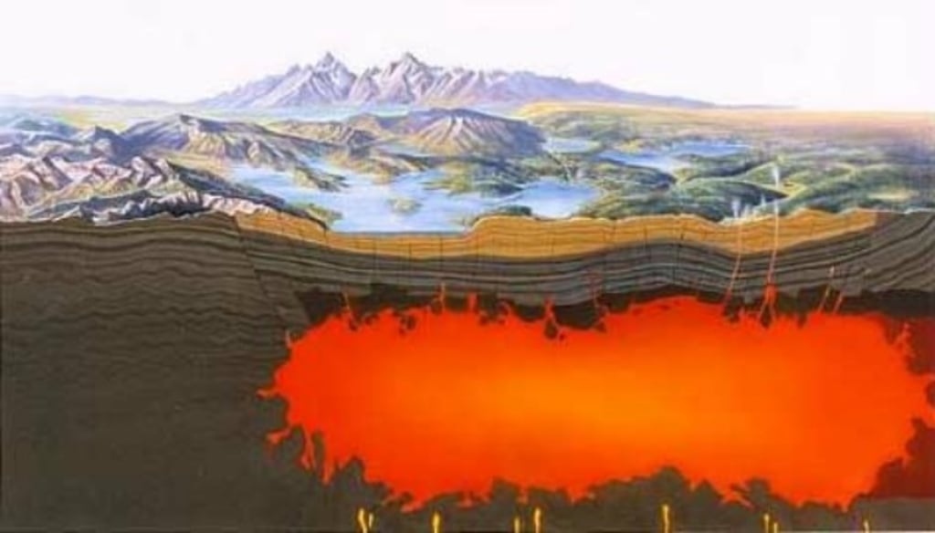
What type of volcano is Yellowstone at depth? It is a “dual-chamber” system. Below the surface lies a shallow rhyolitic chamber and a deeper, much larger basaltic reservoir. Modern supercomputing allows scientists to create 4D models of these chambers. Using Bayesian statistics and physics-based simulations, software can predict how heat transfers between these two layers. This “Digital Twin” of the Yellowstone volcano allows researchers to run “what-if” scenarios, simulating how the system would react to different pressure triggers without needing a real-world event to occur.
4. Hydrothermal Monitoring and Chemical Sensing Tech
Yellowstone is perhaps best known for its hydrothermal features—geysers, mud pots, and hot springs. These are not just tourist attractions; they are the “exhaust pipes” of the volcanic system. Monitoring their chemistry is a high-tech endeavor that defines our understanding of the volcano’s current thermal output.
Remote Gas Sensing and Spectrometry
A key indicator of volcanic type and activity is the composition of gases being released. Yellowstone is a high-silica, gas-rich system. To monitor emissions of Carbon Dioxide (CO2), Sulfur Dioxide (SO2), and Hydrogen Sulfide (H2S), scientists use Multi-GAS (Multiple Gas Sensing System) stations. These automated labs sniff the air and transmit chemical concentrations via cellular or satellite networks. Additionally, Fourier Transform Infrared (FTIR) spectrometry allows for the remote analysis of gas plumes from a distance, using infrared light to identify chemical signatures without placing researchers in harm’s way.
Monitoring Thermal Fluctuations with Satellite Imagery
The “type” of heat Yellowstone produces is colossal. To track the park’s total thermal energy, NASA’s Landsat satellites and the MODIS (Moderate Resolution Imaging Spectroradiometer) instruments are utilized. By analyzing thermal infrared bands, tech experts can calculate the “Radiated Thermal Power” of the entire park. If a new thermal area appears—as one did recently near Tern Lake—satellite tech is the first to detect the heat signature. This allows for a macro-level view of the volcano’s “metabolism” that ground sensors might miss.
5. The Future of Volcanology: Quantum Computing and Deep Earth Imaging
As we look forward, the technology used to categorize and monitor the Yellowstone volcano is entering the realm of science fiction. The goal is to move from reactive monitoring to proactive forecasting.
4D Seismic Tomography
Traditional tomography provides a 3D “X-ray” of the earth. However, the next frontier is 4D tomography—adding the element of time. By using ambient noise correlation (a technique that uses the earth’s natural hum to “see” underground), scientists are developing software that can create a moving picture of the magma chamber. This tech requires massive computational power, pushing the boundaries of current server architecture to visualize the “mush” (a mix of solid crystals and liquid melt) that characterizes the Yellowstone reservoir.

Towards an Early Warning System
The ultimate tech goal for the Yellowstone volcano is the development of an integrated Early Warning System (EWS). By combining IoT sensor data, satellite feeds, and AI-driven analysis into a single dashboard, the YVO aims to create a “volcanic weather forecast.” This digital infrastructure is designed to provide weeks or months of lead time before any significant geological event. While Yellowstone remains quiet for now, the technology surrounding it ensures that it is the most well-understood rhyolitic caldera in human history.
In conclusion, when we ask “what type of volcano is the Yellowstone volcano,” we are describing a complex, silicic super-system. But more importantly, from a tech perspective, Yellowstone is a massive, natural data-generator. It is a testament to human ingenuity that we can monitor a giant sleeping beneath the crust using a sophisticated web of software, satellites, and silicon. Through this technological lens, we don’t just see a volcano; we see the future of planetary monitoring and digital security for the natural world.
aViewFromTheCave is a participant in the Amazon Services LLC Associates Program, an affiliate advertising program designed to provide a means for sites to earn advertising fees by advertising and linking to Amazon.com. Amazon, the Amazon logo, AmazonSupply, and the AmazonSupply logo are trademarks of Amazon.com, Inc. or its affiliates. As an Amazon Associate we earn affiliate commissions from qualifying purchases.