
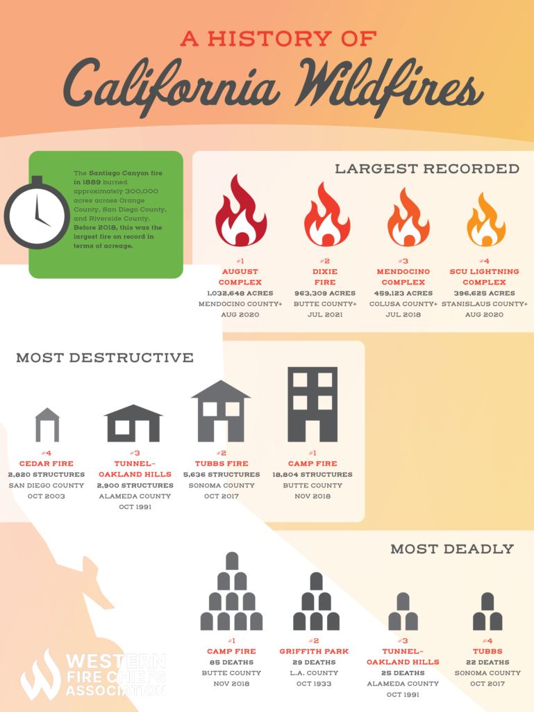
California’s annual wildfire season has become an increasingly dire reality, bringing with it immeasurable loss, ecological devastation, and a profound sense of urgency. The question “what started the wildfire in California?” resonates deeply not just as an inquiry into an immediate event, but as a critical technical challenge whose answer holds the key to future prevention. Beyond the tragic human and environmental toll, these fires represent complex puzzles that modern technology is increasingly adept at solving. From advanced forensic tools that pinpoint ignition sources to sophisticated AI models predicting risk and innovative infrastructure designed to mitigate hazards, technology is at the forefront of understanding, combating, and ultimately preventing the devastating blazes that plague the Golden State. This article delves into how technology, across its myriad applications, is revolutionizing our ability to unravel the origins of wildfires and build a more resilient future.
Unraveling Ignition Points: Digital Forensics in Wildfire Investigations
Understanding what initiates a wildfire is the first, most crucial step in preventing future occurrences. In California, where numerous factors—from human activity and faulty infrastructure to natural phenomena—can spark a blaze, technology offers an unprecedented capability for forensic analysis. Digital tools and advanced sensors are transforming the traditional investigation process, allowing experts to reconstruct events with remarkable precision.
Satellite Imagery and Remote Sensing for Origin Tracing
The vast scale of California’s landscape makes ground-level investigation alone incredibly challenging. This is where satellite technology provides a crucial vantage point. High-resolution satellite data from platforms like MODIS, VIIRS, and the European Space Agency’s Sentinel program offer invaluable post-fire insights. By analyzing thermal anomalies, which indicate heat signatures, and scrutinizing burn scar patterns, investigators can often narrow down potential ignition zones from orbit. Spectral analysis, which measures the unique light signatures reflected by different materials, further aids in differentiating between types of burnt vegetation or structures, offering subtle clues about the fire’s behavior and potential starting point. Overlays of historical satellite data can even reveal changes in vegetation density or dryness that might have contributed to the fire’s severity, helping to build a comprehensive picture of pre-fire conditions. These digital eyes in the sky serve as an essential first layer of forensic evidence, guiding more detailed investigations on the ground.
Drone Technology and AI-Enhanced Ground Surveys
Once satellite data has identified potential areas of interest, drone technology takes the investigation to a granular level. Unmanned Aerial Vehicles (UAVs) equipped with an array of sensors—including high-resolution optical cameras, thermal imagers, and LiDAR (Light Detection and Ranging) systems—can survey burn sites too dangerous or inaccessible for human investigators. Drones provide detailed, close-range data, mapping burn patterns with centimeter-level accuracy and identifying micro-features that could be critical evidence, such as the distinct charring patterns indicative of specific ignition sources (e.g., a lightning strike versus an electrical arc).
Crucially, the sheer volume of imagery and data collected by drones is increasingly processed by AI algorithms. These algorithms are trained to recognize patterns and anomalies indicative of particular causes, such as the unique marks left by a downed power line, discarded items, or even specific tree fall patterns. By automating the preliminary analysis of vast datasets, AI significantly accelerates the identification of critical evidence, allowing human experts to focus on in-depth examination of the most promising leads. This synergy between autonomous data collection and intelligent analysis represents a significant leap forward in pinpointing exact ignition points.
Data Integration and Predictive Modeling for Reconstruction
The final piece of the digital forensics puzzle lies in integrating all collected data into a cohesive, interactive framework. Geographic Information Systems (GIS) play a central role, layering satellite imagery, drone maps, weather data, topographical information, vegetation types, and infrastructure locations into a single, comprehensive digital environment. Forensic experts use these GIS platforms to meticulously reconstruct fire events, tracing the fire’s path backward from its spread pattern to its likely point of origin.
Further enhancing this process are sophisticated simulation software and predictive modeling tools. These applications can take observed burn patterns, combined with historical weather data and fuel models, and run simulations that essentially reverse-engineer the fire’s behavior. By identifying the initial spark that would most accurately produce the observed burn scar, these models provide powerful corroborating evidence or new hypotheses for the investigation team. This data-driven approach transforms wildfire forensics from a largely observational science into an exact, technology-enabled discipline capable of delivering highly accurate conclusions about what started the blaze.
Proactive Defenses: AI, IoT, and Predictive Analytics for Prevention
While understanding past ignitions is vital, the ultimate goal is to prevent future ones. Here, technology shifts from retrospective analysis to proactive defense, leveraging artificial intelligence, the Internet of Things, and advanced analytical models to predict, monitor, and mitigate wildfire risk before a spark ever ignades.
AI-Driven Risk Assessment and Early Warning Systems
Artificial Intelligence stands as a cornerstone of modern wildfire prevention, particularly in its capacity for predictive analysis. AI models, powered by machine learning algorithms, are trained on vast datasets encompassing historical fire occurrences, real-time weather patterns (temperature, humidity, wind speed, lightning strikes), fuel loads (vegetation type and dryness), and human activity patterns. These models can identify intricate correlations and subtle indicators that precede a fire event, allowing them to predict areas and conditions of high risk with unprecedented accuracy.
Sophisticated systems now create “digital twins” of entire landscapes, simulating how fire might behave under various environmental conditions, including different wind speeds, humidity levels, and fuel moistures. This allows planners to test prevention strategies virtually before implementing them. Furthermore, AI-driven systems are pivotal in triggering early warning alerts, notifying authorities and residents when conditions become ripe for ignition and rapid spread. These systems can issue warnings for potential “red flag” days, recommending preemptive actions like power shutoffs or increased surveillance, thereby directly addressing factors that could start a fire.
The Internet of Things (IoT) in Vegetation Management
The Internet of Things (IoT) provides the critical sensory layer for real-time environmental monitoring. Networks of rugged, low-power IoT sensors are strategically deployed across forests, wildland-urban interface (WUI) zones, and critical infrastructure corridors. These sensors continuously monitor key parameters such as ambient temperature, relative humidity, wind speed and direction, and crucially, fuel moisture content within vegetation.
By transmitting this data wirelessly to central analytical platforms, IoT devices provide a dynamic, granular picture of wildfire risk. Anomalously dry or hot spots, indicative of increased flammability, can be immediately identified. Automated alerts are generated for areas where vegetation might be reaching dangerously low moisture levels, prompting targeted vegetation management interventions, such as prescribed burns or mechanical clearing, to remove potential fuel sources before they can contribute to a wildfire’s start or spread. This constant, data-driven oversight helps proactive land managers tackle specific conditions that could otherwise lead to ignition.
Advanced Climate Modeling for Long-Term Strategy
Beyond immediate predictions, advanced climate modeling, powered by supercomputing capabilities, offers a long-term strategic perspective on wildfire prevention. These sophisticated models integrate global climate data with regional geographical specifics to predict long-term trends in drought severity, heatwave frequency, and seasonal precipitation patterns. For California, these models are indispensable in understanding how a changing climate is increasing the fundamental risk factors for wildfires.
The insights gleaned from climate modeling inform strategic land-use planning, guiding decisions on where to build, how to manage natural resources, and when to schedule large-scale prescribed burns. They help identify areas likely to experience prolonged periods of extreme dryness, directing investment towards targeted fuel reduction and infrastructure hardening in those zones years in advance. By providing a macro-level understanding of future conditions, climate models ensure that current prevention efforts are not just reactive but are aligned with the evolving environmental challenges that influence wildfire initiation.

Safeguarding Infrastructure: Tech-Driven Solutions Against Human and Equipment Errors
A significant portion of California’s wildfires has been linked to human activity and failures in critical infrastructure, particularly power utility equipment. Technology is now central to mitigating these specific ignition sources, transforming how utilities operate and how high-risk areas are monitored.
Smart Grid Technology and De-Energization Systems
Electric utility infrastructure, historically a major ignition source, is undergoing a profound transformation through smart grid technology. Advanced sensors installed on power lines, utility poles, and transformers continuously monitor for faults, arcing, and vegetation encroachment in real-time. These sensors can pinpoint the exact location of a problem, often before it causes a fire.
Critically, smart grids enable sophisticated Public Safety Power Shutoff (PSPS) systems. During periods of extreme fire weather, AI algorithms analyze real-time data from weather stations, fuel moisture sensors, and predictive models to determine when and where de-energizing power lines is necessary to prevent ignitions. These systems can be remotely activated, cutting power to specific sections of the grid to eliminate the risk of sparks from equipment failure or contact with vegetation, thereby directly preventing a potential fire start. AI also optimizes these decisions, aiming to minimize the impact on customers while maximizing safety.
Advanced Surveillance and Anomaly Detection
To catch potential ignitions early or identify unauthorized activities, advanced surveillance technologies are being deployed. Fixed cameras, often equipped with thermal imaging and AI-powered anomaly detection, provide continuous monitoring of high-risk wildland areas and sensitive infrastructure. These systems can automatically detect unusual heat signatures, smoke plumes, or even human presence in restricted zones, flagging potential ignition events much faster and more reliably than traditional human patrols.
Drones equipped with similar thermal and optical capabilities perform regular aerial patrols, especially during fire season, to inspect remote power lines, pipelines, and other infrastructure for faults or hazards. The AI component in these systems allows for rapid processing of visual data, identifying compromised equipment or unexpected heat sources that could indicate an imminent threat. This constant, automated vigilance significantly reduces the window for a small spark to escalate into a major wildfire.
Robotics and Automation in Maintenance and Hazard Reduction
Robotics and automation are increasingly being utilized for maintenance and hazard reduction, especially in areas that are dangerous or difficult for human crews to access. Automated vehicles and specialized robots can be deployed to clear overgrown vegetation around power lines, roads, and other potential ignition sources. These machines can operate on steep slopes or in dense brush, performing tasks that are hazardous and time-consuming for human workers.
Autonomous inspection drones are also invaluable for pre-emptive maintenance. They can meticulously inspect infrastructure, identifying frayed wires, failing components, or encroaching vegetation that needs to be cleared, often using high-resolution imaging and LiDAR to build 3D models of the infrastructure and surrounding environment. By systematically addressing these maintenance needs before they become ignition hazards, robotics and automation play a crucial role in preventing fires originating from equipment failures or vegetation contact.
Beyond the Burn: Leveraging Technology for Rapid Response and Future Resilience
Even with the most advanced prevention measures, wildfires will unfortunately still occur. In these scenarios, technology shifts focus to rapid response, minimizing damage, and then looking forward to building more resilient communities through tech-enabled planning and construction.
Real-Time Information for Firefighting and Emergency Management
Once a wildfire ignites, technology becomes the backbone of an effective response. GPS-enabled mapping systems provide real-time situational awareness for firefighters, displaying fire perimeters, crew locations, natural barriers, and evacuation routes on ruggedized tablets and in command centers. Integrated with real-time weather overlays and satellite communication, these systems allow incident commanders to make rapid, data-driven decisions on resource deployment and tactical maneuvers.
AI-driven fire spread prediction models are critical during an active blaze. These models synthesize real-time data on wind, topography, fuel type, and current fire behavior to project the fire’s probable path hours or days into the future. This allows emergency managers to issue precise evacuation orders, pre-position resources, and protect critical infrastructure more effectively. Furthermore, augmented reality (AR) is beginning to be used in command centers, overlaying complex data visualizations onto physical maps or 3D terrain models, providing an immersive and highly intuitive understanding of the unfolding crisis.
Building with Resilience: Tech in Fire-Resistant Construction
After a devastating fire, the imperative shifts to rebuilding smarter. Technology plays a crucial role in constructing fire-resistant homes and communities. New materials, often developed through advanced materials science, are designed to withstand extreme heat and embers, significantly reducing the likelihood of a structure igniting even when directly exposed to a wildfire. These include specialized exterior sidings, roofing materials, and fenestration (windows and doors) that meet rigorous fire-resistance standards.
Beyond materials, smart home systems are integrating wildfire defense features. Sensors can detect approaching embers or rising external temperatures, automatically activating exterior sprinkler systems or deploying fire-resistant shutters. Digital tools for architects and urban planners enable the design of fire-adapted communities, where defensible space, material choice, community-wide warning systems, and well-planned evacuation routes are integrated from the ground up, reducing the susceptibility of homes to ignition during future events.
Data-Driven Policy and Investment in Prevention
The comprehensive data collected through all these technological means—from forensic investigations and predictive analytics to real-time response data—forms an invaluable feedback loop for policy makers. This rich dataset provides an empirical basis for understanding which prevention strategies are most effective, where investments are most needed, and how regulations can be improved to mitigate future risks.
Data-driven insights justify significant investment in new technologies for prevention, early detection, and response. Governments and utility companies can use this information to allocate funds more strategically, funding research into next-generation fire detection sensors, deploying more advanced smart grid components, or expanding drone surveillance programs. This continuous cycle of data collection, analysis, and informed policy ensures that California’s approach to wildfires is constantly evolving, leveraging the latest technological advancements to build a future where the question “what started the wildfire?” is asked less frequently and answered with greater precision, leading to proactive solutions.
Conclusion
The question “what started the wildfire in California?” is no longer solely a mystery to be solved by boots-on-the-ground investigation. Today, it represents a multifaceted technological challenge that requires a holistic, data-driven approach. From the digital forensics that meticulously trace a fire’s origins back to a single spark, to the AI-powered predictive models that anticipate danger, and the smart infrastructure designed to eliminate common ignition sources, technology is rapidly transforming our capacity to understand, prevent, and respond to these devastating events. While the inherent complexities of California’s landscape and climate ensure that wildfires will remain a threat, the continuous innovation in tech—from sensors and software to robotics and advanced analytics—offers a powerful toolkit for building a more resilient future. The path forward is clear: sustained investment, collaborative development, and seamless integration of these technologies with human expertise are essential to safeguard California from the ever-present threat of wildfires, ensuring that “what started it” becomes a question with fewer answers each year.
aViewFromTheCave is a participant in the Amazon Services LLC Associates Program, an affiliate advertising program designed to provide a means for sites to earn advertising fees by advertising and linking to Amazon.com. Amazon, the Amazon logo, AmazonSupply, and the AmazonSupply logo are trademarks of Amazon.com, Inc. or its affiliates. As an Amazon Associate we earn affiliate commissions from qualifying purchases.