
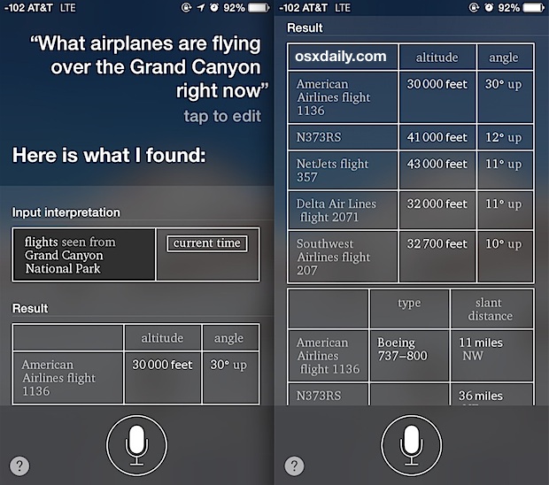
The hum of engines overhead is a familiar sound, a constant reminder of the intricate dance of air travel unfolding above us. For millennia, observing these aerial behemoths was a purely speculative exercise, relying on eyesight and a keen ear. Today, however, technology has transformed this casual curiosity into an accessible, real-time data experience. Whether you’re an aviation enthusiast, a concerned family member tracking a loved one’s flight, or simply intrigued by the aerial ballet unfolding in your local airspace, a wealth of digital tools puts unprecedented information at your fingertips. From sophisticated satellite networks to clever smartphone applications, understanding “what planes are over me right now” is no longer a mystery, but a testament to the power of modern technological convergence. This article delves into the fascinating world of flight tracking, exploring the underlying technologies, essential tools, and the broader implications of this real-time aerial surveillance.
The Technological Backbone: How Flight Tracking Works
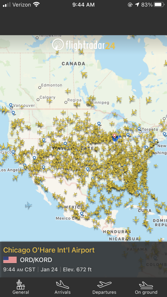
At its core, real-time flight tracking is a triumph of data aggregation and dissemination. It relies on a mosaic of technologies that capture, transmit, and interpret vast amounts of information generated by every aircraft in the sky. Far from being a single, monolithic system, it’s a dynamic interplay of broadcast signals, ground-based receivers, and sophisticated software platforms that piece together the global air traffic picture.
The Power of ADS-B: A Digital Broadcast from Every Aircraft
The cornerstone of modern flight tracking, particularly for civilian aircraft, is Automatic Dependent Surveillance-Broadcast (ADS-B). This revolutionary technology mandates that aircraft continuously broadcast their position, altitude, speed, heading, and other vital data directly from their onboard GPS receivers. Unlike traditional radar, which “pings” an aircraft and measures the reflected signal, ADS-B is an “out” system – the aircraft itself is broadcasting. This digital signal is openly available and can be picked up by anyone with a compatible receiver. The beauty of ADS-B is its precision and the sheer volume of data it provides, offering a much more granular and up-to-date picture than older systems. This technology has significantly enhanced air traffic control capabilities and safety, but its open nature also fuels the public flight tracking ecosystem.
Complementary Data Sources: Radar, Satellites, and Internet Connectivity
While ADS-B is dominant, it’s not the only piece of the puzzle. Traditional radar systems, operated by air traffic control agencies worldwide, still play a crucial role, especially for older aircraft not equipped with ADS-B or in areas with limited ADS-B ground coverage. Radar provides primary surveillance by detecting aircraft and secondary surveillance by interrogating transponders. Furthermore, satellite-based ADS-B receivers are becoming increasingly important. These satellites pick up ADS-B signals from aircraft flying over oceans and remote landmasses where ground-based receivers are non-existent, providing truly global coverage. Finally, the internet acts as the circulatory system, carrying all this disparate data – from ADS-B ground stations, satellite networks, and radar feeds – to central servers where it’s processed, combined, and then distributed to end-users via websites and applications.
From Raw Data to Real-Time Maps: The Role of Aggregators
The sheer volume of raw flight data would be incomprehensible without the sophisticated platforms that aggregate, filter, and visualize it. Companies like FlightAware, Flightradar24, and ADS-B Exchange operate vast networks of ADS-B receivers, often relying on a global community of volunteers who host these receivers. These aggregators collect the data, cross-reference it with flight plans, airline schedules, and airport information, and then present it on user-friendly maps. Advanced algorithms clean the data, predict flight paths, and calculate estimated times of arrival, transforming a stream of digital signals into the interactive, real-time flight maps we’ve come to rely on. This powerful aggregation capability is what truly makes identifying “what planes are over me right now” an intuitive and informative experience.
Essential Apps and Tools for Real-Time Aircraft Identification
The primary interface for most users to access this wealth of aerial information is through a variety of applications and online platforms. These tools transform complex data streams into intuitive, interactive maps and detailed flight information, suitable for both casual observers and dedicated aviation enthusiasts.
Top-Tier Flight Tracking Applications: A Comparative Look
Several leading applications dominate the flight tracking landscape, each with its strengths and unique features.
-
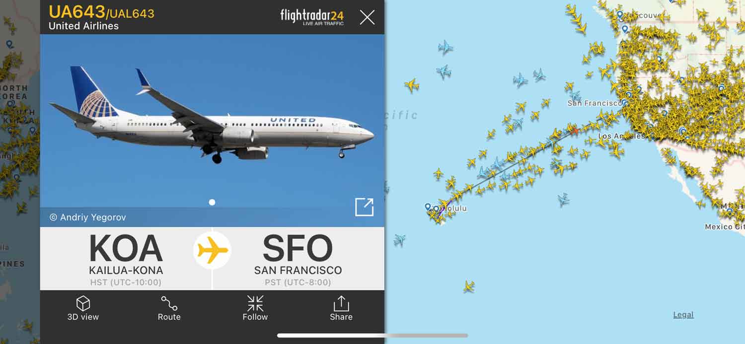
Flightradar24: Perhaps the most widely recognized, Flightradar24 offers an exceptionally user-friendly interface with global coverage. Its map displays a vibrant array of aircraft icons, clickable to reveal detailed information such as aircraft type, airline, flight number, origin, destination, altitude, speed, and even a 3D cockpit view for some flights. It leverages ADS-B, MLAT (Multilateration for non-ADS-B equipped aircraft), and satellite data.
-
FlightAware: Another robust contender, FlightAware provides comprehensive real-time flight tracking, historical data, and predictive capabilities. It’s often favored by aviation professionals and travelers due to its reliable data and extensive coverage, including private and general aviation flights in many regions. It also offers FlightAware Global, a premium service with advanced features.
-
ADS-B Exchange: For those who prefer raw, unfiltered data and a community-driven approach, ADS-B Exchange is invaluable. It focuses on providing as much open, unblocked ADS-B data as possible, making it a favorite for researchers and hobbyists interested in seeing all aircraft, including those often filtered out by commercial trackers for privacy reasons. Its interface is less polished but incredibly functional for detailed analysis.
-
Plane Finder: Offering similar functionalities to Flightradar24 and FlightAware, Plane Finder distinguishes itself with a clean interface and powerful augmented reality (AR) features. Pointing your device’s camera at the sky can overlay flight information directly onto your view, making identification of overhead aircraft incredibly intuitive.
Each app offers a free version with core features, often complemented by premium subscriptions that unlock historical data, advanced filters, commercial-free experiences, and more detailed aircraft information.
Beyond the Basics: Features That Enhance Your Sky-Gazing
Modern flight tracking apps go far beyond simple position plotting. Many offer features designed to enhance the user experience and provide deeper insights:
-
Augmented Reality (AR): As mentioned with Plane Finder, AR allows users to hold their smartphone or tablet up to the sky and see flight information superimposed directly onto the live camera feed, identifying planes with remarkable ease.
-
Push Notifications: Set up alerts for specific flights, airlines, or aircraft types. Receive notifications when a flight departs, arrives, or experiences delays, perfect for tracking loved ones or specific interesting aircraft.
-
Historical Data: Most apps offer access to historical flight data, allowing users to review past flights, analyze traffic patterns, or investigate specific incidents. Premium versions often provide more extensive historical archives.
-
Filters and Search: Refine your view by filtering aircraft based on airline, aircraft type, altitude, speed, origin/destination, or even specific registration numbers. This is invaluable for pinpointing exactly “what planes are over me right now” from a multitude of options.
-
Airport Activity: View real-time arrivals and departures boards for major airports, see ground movements, and track specific aircraft on the tarmac.
Hardware for the Enthusiast: Setting Up Your Own Receiver
For the ultimate enthusiast or those in areas with poor commercial tracking coverage, setting up your own ADS-B receiver is an accessible project. Using a relatively inexpensive Software Defined Radio (SDR) dongle connected to a computer or Raspberry Pi, along with a dedicated antenna, anyone can become a part of the global flight tracking network. By feeding your collected data to aggregators like Flightradar24 or ADS-B Exchange, you contribute to the collective intelligence, often receiving premium features in return. This DIY approach not only provides direct access to real-time data but also offers a fascinating insight into the technical underpinnings of the entire system.
Interpreting the Data: What Those On-Screen Details Mean
Once you’ve launched your chosen app and located aircraft overhead, the screen often presents a wealth of information. Understanding these details transforms a simple dot on a map into a comprehensive narrative about an aircraft’s journey and identity.
Deconstructing the Flight Information Panel
Clicking on an aircraft icon typically brings up a dedicated information panel, packed with critical data:
-
Flight Number (e.g., BA286, UAL345): This unique identifier corresponds to a specific scheduled service by an airline.
-
Airline and Aircraft Type (e.g., British Airways, Boeing 747): Identifies the operator and the model of the aircraft.
-
Origin and Destination (e.g., London Heathrow to Los Angeles LAX): The planned start and end points of the flight.
-
Altitude (e.g., 35,000 ft): The aircraft’s current height above sea level, typically displayed in feet.
-
Speed (e.g., 500 mph, 800 km/h, Mach 0.85): The ground speed or airspeed of the aircraft.
-
Heading/Track (e.g., 270° W): The direction the aircraft is currently flying.
-
Vertical Speed (e.g., +1000 ft/min, -500 ft/min): How quickly the aircraft is climbing or descending.
-
Estimated Time of Arrival (ETA): The projected time the flight will reach its destination.
-
Registration Number (e.g., G-XXXX, N123AB): A unique alphanumeric code painted on the aircraft, similar to a car’s license plate, indicating its country of registration and specific identity.
Understanding these parameters allows you to quickly grasp the context of any flight you observe, whether it’s a transatlantic journey or a local sightseeing tour.
Understanding Aircraft Types and Registrations
Beyond the flight numbers, identifying the specific aircraft type and its registration number adds another layer of detail for the keen observer. Aircraft types range from colossal Airbus A380s and Boeing 747s, to smaller regional jets like the Embraer E-Jets, and even tiny single-engine Cessnas. Each type has distinct characteristics and common routes.
The registration number is particularly interesting. Every aircraft globally carries a unique registration, typically starting with a prefix indicating its country of registration (e.g., ‘G-‘ for UK, ‘N’ for USA, ‘D-‘ for Germany). This number can be used to look up an aircraft’s full history, previous owners, and even specific details about its configuration. For enthusiasts, recognizing these numbers and the aircraft types is a core part of the hobby, allowing them to differentiate between commercial traffic, private jets, cargo planes, and even military aircraft if they broadcast ADS-B.
Tracking History and Predictive Flight Paths
Many applications provide not just current positions but also a historical track of an aircraft’s flight path. This feature allows users to see where a plane has been, trace its movements over time, and understand its adherence to its flight plan. Conversely, advanced algorithms use current data, historical patterns, and flight plan information to predict an aircraft’s future trajectory. This predictive capability is crucial for estimating arrival times and understanding potential deviations due to weather or air traffic control instructions. For instance, you can often see a shaded “cone of uncertainty” around an aircraft’s predicted path, indicating the system’s confidence level in its future position. This blend of past, present, and future data paints a complete picture of aerial activity.
Beyond Curiosity: Practical Applications and Broader Implications
The ability to track aircraft in real-time extends far beyond mere curiosity. This technology has profound practical applications, fosters communities, and raises important discussions about privacy and data access.
Enhancing Situational Awareness and Safety
For the general public, flight tracking significantly enhances situational awareness. Parents can track their children’s flights, knowing exactly when they’ve departed or are due to arrive. Travelers can monitor connecting flights, anticipate delays, and adjust their plans accordingly. For those living near airports, it provides insight into noise patterns or unusual flight paths.
More importantly, in specific circumstances, access to this data can be crucial for safety. During emergencies or incidents, real-time flight tracking can provide vital information to first responders and investigative bodies. While official channels have their own dedicated systems, the public availability of ADS-B data, particularly through unfiltered sources like ADS-B Exchange, has occasionally played a role in open-source intelligence gathering during major aviation events. It also allows ordinary citizens to report unusual aerial activity with concrete data points, potentially aiding authorities.
A Thriving Community: From Spotters to Air Traffic Observers
Flight tracking has cultivated a passionate global community. Aviation enthusiasts, known as “spotters,” use these tools to identify specific aircraft, plan their photography sessions, and document rare or interesting visitors to their local airfields. Online forums and social media groups buzz with discussions about unique liveries, military movements, and unusual flight patterns, all facilitated by accessible tracking data.
Beyond hobbyists, the ability to observe air traffic fosters a deeper understanding of the complex logistics and operations of the aviation industry. It allows citizen observers to gain insights into how air traffic control manages crowded airspace, how airlines manage their fleets, and even provides a transparent view into the environmental impact of air travel, through tracking flight altitudes and distances.
Privacy Concerns and the Future of Open Flight Data
While the democratization of flight data offers numerous benefits, it also introduces valid privacy concerns. Owners of private jets, for instance, may not wish their precise movements to be publicly trackable. Many commercial flight tracking services offer the option for aircraft owners to “block” their flights from public view, although this often only applies to the commercial platforms and not to raw, unfiltered ADS-B data streams. The debate between privacy rights and the public’s right to access open data is ongoing.
Looking ahead, the evolution of flight tracking technology promises even greater precision and coverage. Enhanced satellite networks, advancements in AI for predictive analytics, and the integration of new sensor technologies will likely make the sky an even more transparent and understandable space. As drone traffic increases and new forms of aerial mobility emerge, the principles of real-time tracking will undoubtedly expand to encompass these new layers of the airspace, continuing to put the answers to “what planes are over me right now” firmly in the hands of the public. The sky, once a realm of mystery, has become an open book, thanks to the relentless march of technological innovation.
aViewFromTheCave is a participant in the Amazon Services LLC Associates Program, an affiliate advertising program designed to provide a means for sites to earn advertising fees by advertising and linking to Amazon.com. Amazon, the Amazon logo, AmazonSupply, and the AmazonSupply logo are trademarks of Amazon.com, Inc. or its affiliates. As an Amazon Associate we earn affiliate commissions from qualifying purchases.