In the modern era, the phrase “Tornado Warning” has evolved from a simple siren on a street corner into a complex, multi-layered digital event. When your smartphone emits a piercing, high-pitched tone and a text box appears on your screen, you are witnessing the culmination of billions of dollars in aerospace technology, high-speed data processing, and sophisticated communication protocols. To understand what a tornado warning means in a technical sense is to understand the intersection of meteorology, computer science, and telecommunications infrastructure.
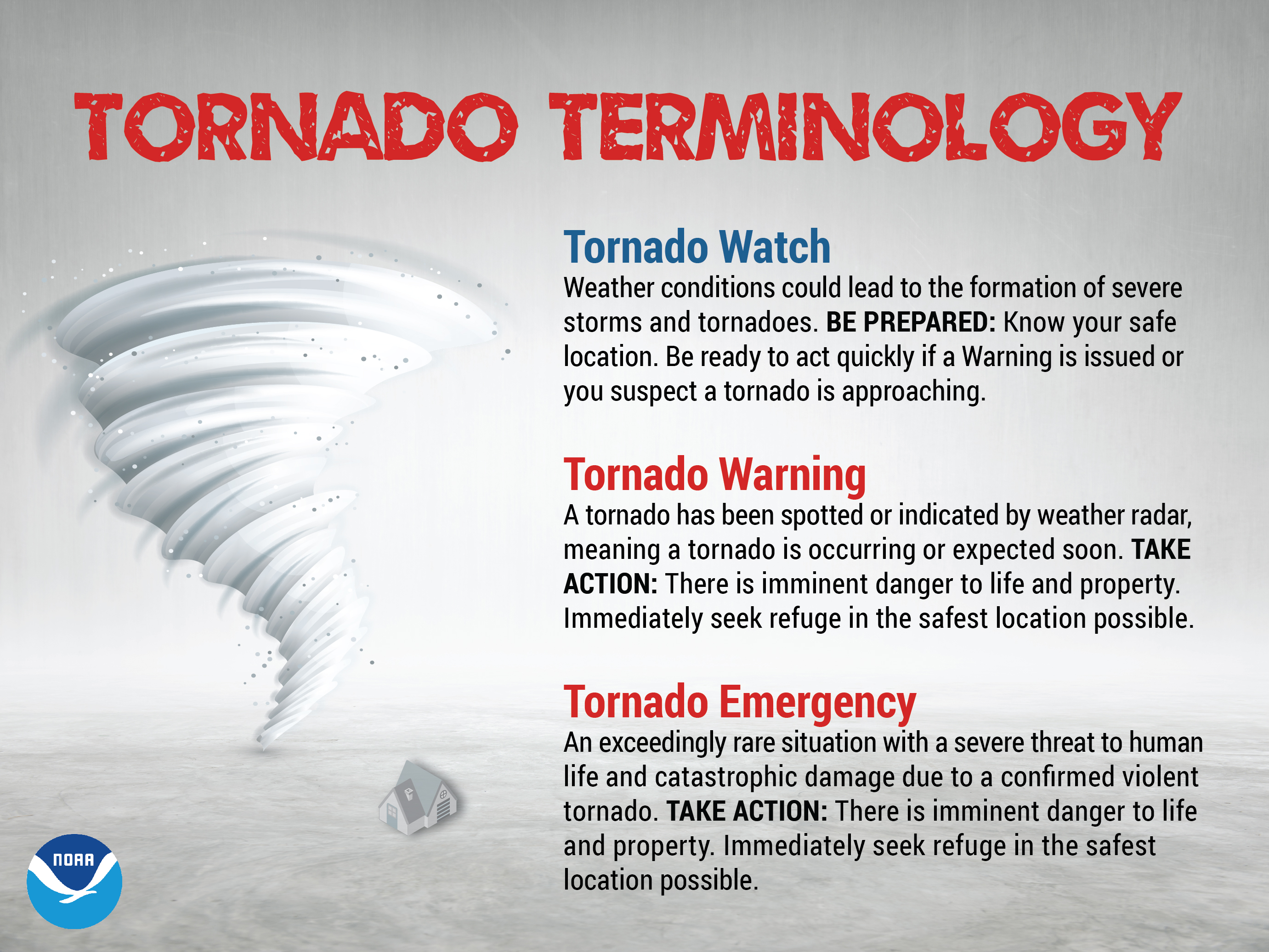
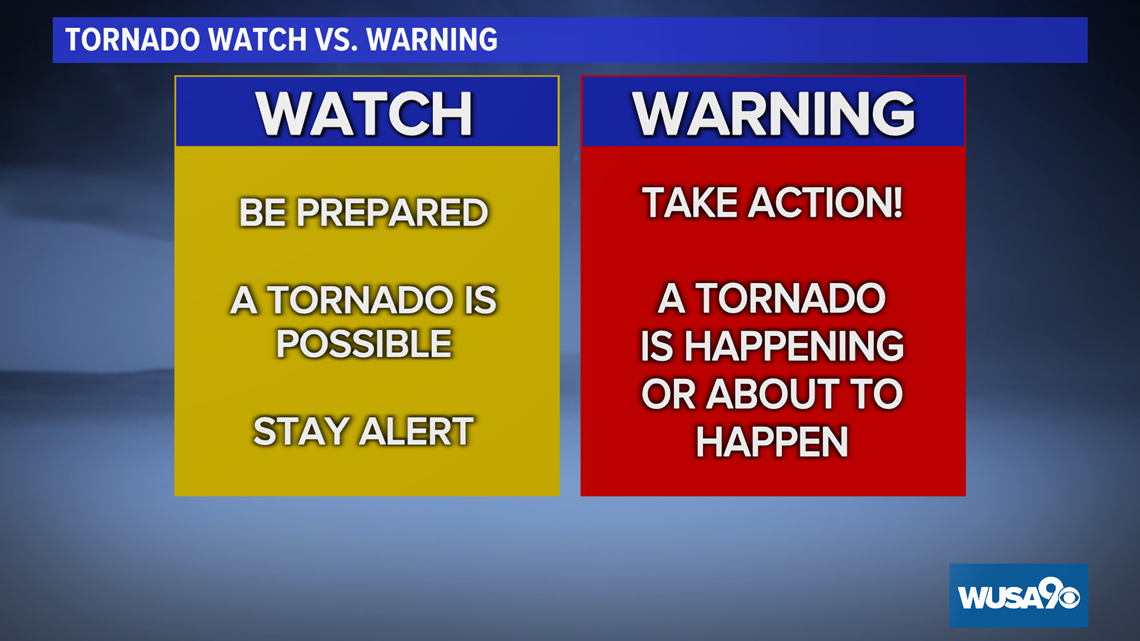
A tornado warning is a high-priority data packet triggered by specific atmospheric conditions or radar-detected signatures. Unlike a “tornado watch,” which signifies the potential for development based on predictive modeling, a “warning” indicates that a tornado is either occurring or is imminent. From a technological standpoint, this is the shift from probabilistic forecasting to real-time event detection and dissemination.
The Digital Infrastructure of Modern Meteorological Alerts
The journey of a tornado warning begins long before it reaches your device. It starts with a network of sophisticated hardware distributed across the landscape, primarily the NEXRAD (Next-Generation Radar) system.
From Pulse-Doppler Radar to Dual-Polarization
The technical backbone of the tornado warning system is the WSR-88D radar. Modern meteorology relies on Dual-Polarization (Dual-Pol) technology. Unlike older radars that only sent out horizontal pulses, Dual-Pol sends both horizontal and vertical pulses. This allows the system’s software to identify the size, shape, and variety of particles in the air.
When meteorologists look for a tornado, they aren’t just looking for a “hook echo” on a screen; they are looking for a Correlation Coefficient (CC) drop. This is a digital signature indicating that the radar pulses are hitting non-uniform objects—debris. When a computer algorithm identifies a “Tornado Debris Signature” (TDS), the data is flagged as a high-priority alert. This technological leap has significantly reduced false alarm rates and increased lead times.
The Role of Supercomputing in Pattern Recognition
Behind the raw radar data are massive supercomputers running Numerical Weather Prediction (NWP) models. These machines process petabytes of data from satellites, weather stations, and weather balloons. Algorithms like the Tornado Detection Algorithm (TDA) constantly scan radar volumes for specific patterns of gate-to-gate shear—essentially looking for pixels of air moving rapidly toward the radar adjacent to pixels moving rapidly away. This digital “vortex” detection allows the National Weather Service (NWS) to issue warnings with mathematical precision, often before a human eye has even spotted the rotation on a traditional display.
How Your Devices Interpret Warning Data
Once a warning is issued by a meteorologist, it enters a complex digital distribution network. What “tornado warning” means for your hardware is the reception of a specific set of protocols designed to bypass standard traffic.
Wireless Emergency Alerts (WEA) and Cell Broadcasting
The most common way people receive warnings today is through Wireless Emergency Alerts (WEA). This is not a standard SMS text message. If the government sent a text to every phone in a city simultaneously, the network would collapse under the congestion.
Instead, WEA uses “Cell Broadcasting.” This technology allows a cell tower to broadcast a message to every enabled handset within its reach without needing to know the specific phone numbers. The message is sent on a dedicated frequency that bypasses the normal voice and data channels. This is why you might receive an alert even if your signal is too weak to make a phone call or browse the web. The “meaning” of a tornado warning on your phone is a specialized hardware-level interrupt that forces the device to play a specific audio frequency and display a high-priority system dialogue.
The API Economy of Weather Apps
Beyond the built-in government alerts, a vast ecosystem of third-party apps (such as RadarScope, The Weather Channel, or Baron Critical Weather) utilizes APIs (Application Programming Interfaces) to pull data directly from the Integrated Public Alert and Warning System (IPAWS).
These apps translate the raw GeoJSON or CAP (Common Alerting Protocol) data into visual overlays. When a warning is issued, it is defined by a “polygon”—a set of GPS coordinates that form a box on a map. Your weather app constantly checks your device’s location against these dynamic polygons. If your coordinates fall within the mathematically defined boundaries, the app triggers a local notification. This geospatial filtering ensures that users are not alerted for storms that do not pose a direct threat to their specific location.
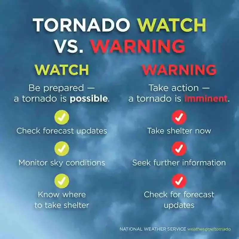
The Difference Between Watch and Warning: A Binary Perspective
In the world of tech and data, the difference between a “Watch” and a “Warning” can be viewed as the difference between a background process and an active system interrupt.
Predictive Modeling vs. Real-Time Detection
A Tornado Watch is the result of long-range predictive modeling. High-resolution ensemble models (like the HRRR—High-Resolution Rapid Refresh) run simulations every hour to determine where atmospheric instability is highest. From a software perspective, a watch is a “conditional statement”: If the temperature profile remains X and moisture reaches Y, then a storm is likely.
A Tornado Warning, however, is a “boolean true” event. It is triggered by “Ground Truth”—either a confirmed sighting by a trained spotter or a radar-confirmed debris ball. In the logic of emergency management, the warning is the execution of a pre-planned script. Once the “Warning” flag is set to “True,” the system automatically initiates a series of automated actions: sirens are triggered via radio frequency, television broadcasts are interrupted via the Emergency Alert System (EAS), and digital signs on highways are updated via centralized control software.
Validating Data: Ground Truth and Spotter Networks
Despite the power of AI and radar, “ground truth” remains a vital data point. This is where human-in-the-loop (HITL) systems come into play. Modern storm spotting uses apps like Spotter Network, which integrates GPS tracking with reporting software. When a spotter submits a report, it is digitally timestamped and geolocated, providing immediate validation to the NWS meteorologists. This data point is then ingested into the warning software to refine the polygon, ensuring that the digital warning matches the physical reality of the storm’s path.
Future Trends: AI and Hyper-Localized Forecasting
The meaning of a tornado warning is currently undergoing a digital transformation. We are moving away from broad county-based alerts toward hyper-localized, AI-driven predictions.
Machine Learning in Tornadogenesis Prediction
The next frontier in weather tech is the application of Machine Learning (ML) to the pre-tornadic environment. Current research focuses on training neural networks on decades of historical radar data to identify the subtle “pre-rotational” signatures that humans might miss.
The goal is to increase “lead time”—the interval between the warning and the actual impact. Currently, the average lead time is about 13 minutes. By using AI to analyze dual-pol variables in real-time, meteorologists hope to push this to 20 or 30 minutes. In this context, a “warning” becomes a predictive alert generated by an algorithm that has recognized a pattern of atmospheric behavior with a 90% or higher confidence interval.
The Integration of IoT and Smart Home Safety
As we move toward the “Internet of Things” (IoT), the meaning of a tornado warning will extend to our physical environment. We are already seeing the integration of emergency alerts with smart home ecosystems.
In the near future, a “Tornado Warning” data packet could automatically trigger a sequence of events in a smart home:
- Smart Lighting: All lights flash red or turn on to full brightness to wake sleeping residents.
- Security Systems: Smart locks on storm shelters automatically disengage for quick access.
- HVAC Systems: Air conditioning units shut down to prevent the intake of debris or smoke in the event of damage.
- Connected Vehicles: Teslas or other EVs could receive the alert and suggest a navigation route out of the storm’s projected path or move themselves into a garage if available.
This interconnectedness turns a warning from a passive message into an active safety protocol.
Conclusion: The Evolution of Digital Safety
Ultimately, what a tornado warning means is that a sophisticated technological net has successfully caught a rare and dangerous atmospheric event. It is a testament to the power of modern sensors, the speed of our cellular networks, and the precision of our software.
When you see that alert, you are seeing the output of a global tech stack designed for one purpose: the preservation of life through data. From the dual-polarized pulses of a radar dish to the cell-broadcast protocols of your smartphone, a tornado warning is the most critical notification you will ever receive. It is a call to action, powered by the most advanced technology humanity has to offer, signaling that it is time to step away from the digital world and seek physical safety. As AI and IoT continue to advance, these warnings will only become more accurate, more localized, and more integrated into the very fabric of our lives, transforming how we survive the most violent weather on Earth.
aViewFromTheCave is a participant in the Amazon Services LLC Associates Program, an affiliate advertising program designed to provide a means for sites to earn advertising fees by advertising and linking to Amazon.com. Amazon, the Amazon logo, AmazonSupply, and the AmazonSupply logo are trademarks of Amazon.com, Inc. or its affiliates. As an Amazon Associate we earn affiliate commissions from qualifying purchases.