
The stratosphere, a crucial layer of Earth’s atmosphere positioned above the troposphere and below the mesosphere, holds profound significance not just for climate science but also for a vast array of technological endeavors. When we ask, “What is the temperature of the stratosphere?”, we are probing a fundamental aspect of atmospheric physics that underpins everything from weather forecasting and climate modeling to aerospace engineering and satellite communication. Understanding its thermal dynamics is not a mere academic exercise; it’s an intricate dance with cutting-edge technology, sophisticated software, and powerful artificial intelligence, essential for navigating our planet’s complex systems and ensuring the resilience of our technological infrastructure.

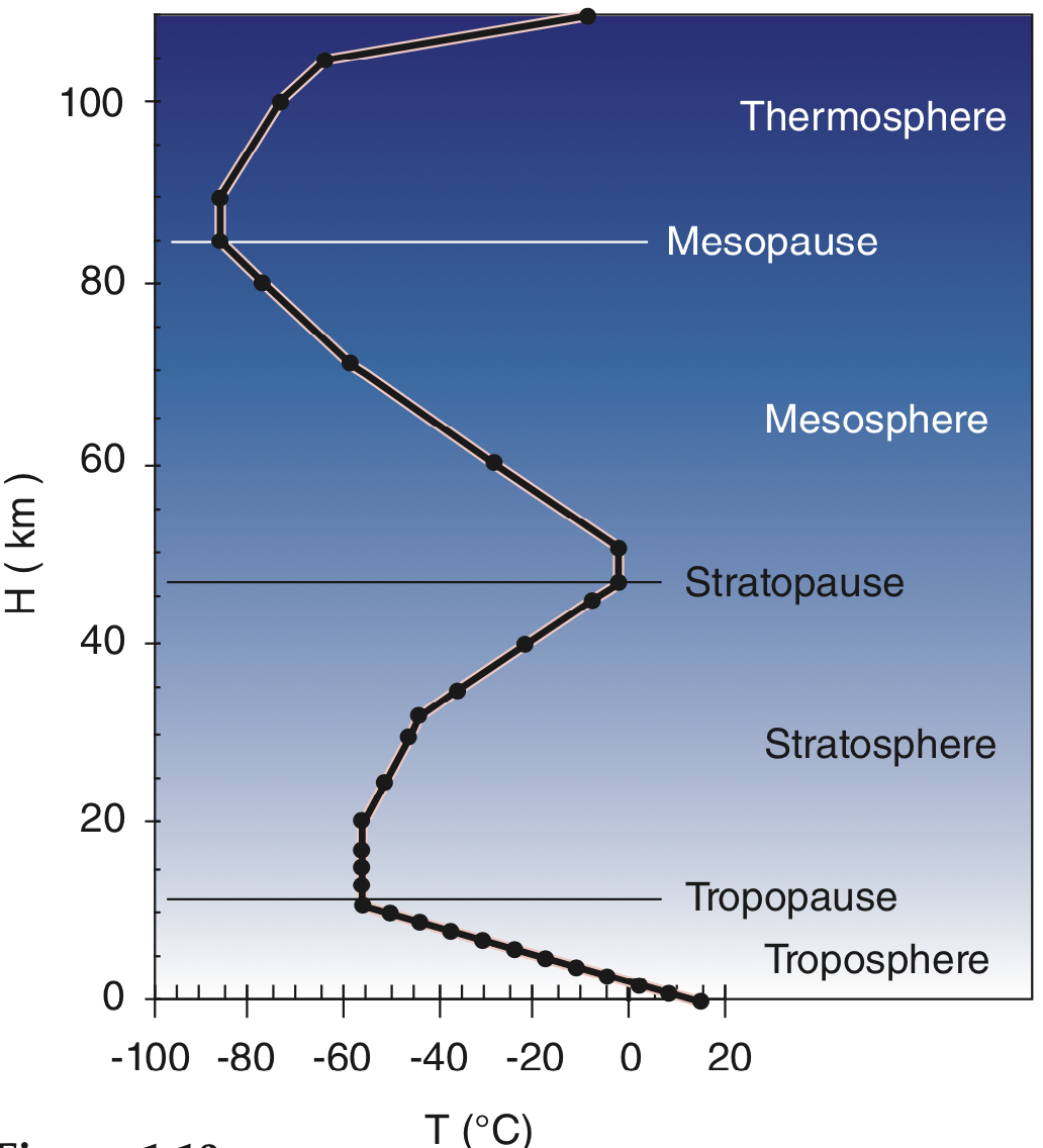
Unlike the troposphere, where temperature generally decreases with altitude, the stratosphere exhibits a unique characteristic: its temperature increases with height. This inverse temperature gradient is primarily due to the presence of the ozone layer, which absorbs ultraviolet (UV) radiation from the sun, converting it into heat. At its lowest point, near the tropopause (the boundary with the troposphere), temperatures can plummet to -60 to -80 degrees Celsius (-76 to -112 degrees Fahrenheit). As one ascends through the stratosphere, absorbing more UV radiation, temperatures gradually rise, reaching closer to 0 degrees Celsius (32 degrees Fahrenheit) or even slightly above at the stratopause, its upper boundary, typically around 50 kilometers (31 miles) above Earth’s surface. This temperature profile is dynamic, influenced by seasonal changes, latitude, solar activity, and even large-scale atmospheric phenomena like Sudden Stratospheric Warmings (SSWs). The ability to precisely measure, monitor, and predict these temperatures is a testament to extraordinary technological innovation.
Precision in the Upper Atmosphere: The Technological Backbone of Stratospheric Monitoring
Accurately determining the temperature of a vast, dynamic atmospheric layer requires a multifaceted approach, blending legacy technologies with state-of-the-art innovation. The continuous evolution of measurement tools and data acquisition systems forms the bedrock of our stratospheric understanding.
From Balloons to Beacons: The Evolution of Measurement Tools
The journey of stratospheric temperature measurement began with relatively simple, yet groundbreaking, tools. Radiosondes, balloon-borne instrument packages, have been a staple since the early 20th century. These weather balloons ascend through the atmosphere, measuring temperature, humidity, pressure, and wind speed, transmitting data back to ground stations. While limited in their spatial and temporal coverage, and ultimately burst at certain altitudes, radiosondes remain invaluable for providing high-resolution vertical profiles, especially for calibrating and validating data from other sources. Their enduring role in weather forecasting underscores their foundational importance.
The advent of the space age revolutionized stratospheric monitoring. Satellite remote sensing emerged as a game-changer, offering global coverage and continuous observation capabilities. Satellites equipped with advanced sensors, such as infrared and microwave radiometers, measure the radiation emitted or absorbed by various atmospheric gases at specific wavelengths. By analyzing these spectral signatures, scientists can infer temperature profiles across different altitudes and geographical regions. For instance, specific channels on instruments like the Atmospheric Infrared Sounder (AIRS) or the Microwave Sounding Unit (MSU) are designed to “see” into the stratosphere. These technologies operate on principles of Planck’s law and radiative transfer, translating emitted radiation intensities into temperature values.
Beyond space, ground-based technologies also play a crucial role. Lidar (Light Detection and Ranging) systems, for example, use pulsed laser beams to probe the atmosphere. By analyzing the backscattered light, scientists can derive precise temperature profiles, particularly useful for studying specific atmospheric layers and phenomena like polar stratospheric clouds. Similarly, advanced radar systems can track atmospheric disturbances and indirectly infer temperature changes. Each technology offers unique advantages, contributing to a comprehensive, multi-instrument view of the stratosphere.
Data Acquisition and Transmission: A Network of Sensors
The sheer scale of stratospheric monitoring demands robust data acquisition and transmission capabilities. Satellites orbiting hundreds of kilometers above Earth must constantly gather vast amounts of raw data, which is then downlinked to ground stations strategically positioned around the globe. This involves complex telemetry systems, ensuring reliable and high-bandwidth communication. The raw data, often subject to noise and atmospheric interference, then undergoes initial processing. For ground-based systems like lidar, localized data is collected and often networked into larger meteorological or climate research databases. The distributed nature of these sensor networks – from individual radiosonde launches to constellations of satellites – generates an immense volume of data with high velocity, posing significant challenges for storage, processing, and real-time analysis. The robust infrastructure supporting this global network is a critical, often unseen, technological marvel.
Navigating the Data Deluge: Software, AI, and Climate Modeling
The raw data flowing from our stratospheric sensors is just the beginning. To transform this cacophony of measurements into actionable insights, sophisticated software and cutting-edge artificial intelligence are indispensable. They form the intellectual engine driving our understanding of stratospheric temperature dynamics.
Sophisticated Software for Data Processing and Analysis
At the heart of stratospheric science lies an intricate ecosystem of sophisticated software for data processing and analysis. Raw satellite measurements, for instance, must undergo rigorous calibration and validation procedures to account for instrument biases, orbital variations, and atmospheric attenuation. Algorithms for noise reduction, atmospheric correction, and inversion are constantly being refined to extract the most accurate temperature information from complex spectral data. Programming languages like Python, MATLAB, and Fortran, coupled with specialized libraries for scientific computing, enable researchers to develop these intricate processing pipelines.
Furthermore, visualization tools are essential for making sense of spatial and temporal temperature datasets. Geographic Information Systems (GIS) platforms and custom-built scientific visualization software allow scientists to map temperature anomalies, track stratospheric warming events, and observe long-term trends across different altitudes and regions. The ability to integrate diverse datasets – combining satellite data with radiosonde profiles, lidar measurements, and even airborne research campaigns – is crucial for cross-validation and building a holistic picture of the stratosphere. This data fusion requires advanced software architectures capable of handling heterogeneous data types and formats.
Artificial Intelligence and Machine Learning in Stratospheric Science
The burgeoning field of Artificial Intelligence (AI) and Machine Learning (ML) is revolutionizing stratospheric science. AI algorithms are increasingly deployed for predictive modeling, enhancing our ability to forecast stratospheric temperature changes, including disruptive events like Sudden Stratospheric Warmings (SSWs). These events, characterized by rapid temperature increases in the polar stratosphere, can have profound “downward coupling” impacts on tropospheric weather patterns, influencing cold snaps and extreme weather events. ML models, trained on decades of observational data, can identify subtle precursors and improve the accuracy and lead time of these critical forecasts.
Anomaly detection is another powerful application. AI can sift through vast datasets to identify unusual temperature patterns, flag potential sensor malfunctions, or pinpoint novel atmospheric phenomena that might be missed by traditional statistical methods. Beyond detection, AI is also playing a significant role in improving the parameterization of complex physical processes within large-scale climate models. Atmospheric models often simplify or “parameterize” processes that occur at scales smaller than the model’s grid resolution. ML algorithms can learn from high-resolution simulations or observational data to develop more accurate and computationally efficient parameterizations for stratospheric dynamics, ozone chemistry, and radiative transfer, leading to more robust climate projections. Moreover, AI can optimize sensor placement and data collection strategies, guiding where new instruments should be deployed to maximize data utility or adapt sampling patterns in real-time based on evolving atmospheric conditions.
Stratospheric Dynamics and Technological Resilience
The intricate dance of stratospheric temperatures isn’t just a scientific curiosity; its fluctuations and long-term trends have tangible implications for human technology, demanding innovation in resilience and adaptation.
Impact on Space-Based Technologies and Communication
The stratosphere, and the layers above it, directly influence the performance and longevity of our space-based technologies. Variations in stratospheric temperature and density can affect the propagation of radio waves, impacting satellite communication links, GPS accuracy, and over-the-horizon radar systems. Unexpected temperature fluctuations can alter atmospheric refractive indices, leading to signal degradation or path errors.
For aerospace vehicles, understanding stratospheric conditions is paramount. High-altitude platforms (HAPs), such as stratospheric balloons and drones, operate directly within this layer, requiring precise knowledge of temperature, wind, and density for navigation, energy management, and payload stability. Supersonic jets and hypersonic vehicles transiting or operating in the lower stratosphere must contend with varying thermal stresses and atmospheric drag. For re-entry vehicles, accurate stratospheric temperature and density profiles are critical inputs for aerodynamic calculations, ensuring safe and predictable descent paths. Furthermore, instruments exposed to the extreme low pressures and varying temperatures of the stratosphere demand specialized material science challenges to ensure their structural integrity and operational reliability.
Climate Change and the Future of Stratospheric Monitoring Tech
In an era defined by climate change, the imperative for continuous, high-resolution stratospheric monitoring has never been greater. While the troposphere warms due to greenhouse gas accumulation, the stratosphere, particularly the upper stratosphere, is projected to cool in response to increased CO2. This differential warming/cooling has profound implications for atmospheric circulation, ozone recovery, and climate feedback mechanisms. Understanding these nuanced changes requires next-generation monitoring technologies.
The future points towards the development of new sensors that are smaller, more energy-efficient, and capable of higher spatial and temporal resolution. This includes miniaturized satellite payloads, networks of interconnected stratospheric drones, and advanced lidar systems that can operate autonomously. AI will be integrated directly into these sensors, enabling on-board processing and adaptive sampling. Furthermore, the sheer volume of data generated by these advanced systems necessitates robust big data analytics and cloud computing infrastructure. Cloud platforms provide the scalable storage and computational power required to process global climate models, integrate diverse observational datasets, and run complex AI simulations, fostering collaborative research and democratizing access to critical atmospheric data.
The Strategic Imperative: Beyond Pure Science
Understanding stratospheric temperature transcends pure scientific inquiry; it’s a strategic imperative with broad implications for planetary defense, global security, and economic innovation.
Early Warning Systems and Planetary Defense
Accurate stratospheric temperature data is a critical component of early warning systems for severe weather. Changes in the stratosphere can cascade downwards, influencing large-scale weather patterns in the troposphere, including the intensity and persistence of cold fronts, heatwaves, and even tropical cyclones. Predictive models, powered by stratospheric observations, contribute to better forecasting capabilities, allowing societies to prepare for and mitigate the impacts of extreme weather.
Beyond terrestrial weather, stratospheric data contributes to planetary defense by aiding in atmospheric entry calculations for space debris, meteoroids, and re-entering spacecraft. Precise knowledge of atmospheric density, influenced by temperature, is crucial for predicting trajectories and potential impact zones. Furthermore, understanding the upper atmosphere has geopolitical implications, as nations strive for superiority in aerospace capabilities, remote sensing, and even potential climate modification technologies, all of which are intrinsically linked to stratospheric conditions.

Innovation and Investment in Atmospheric Tech
The ongoing quest to understand the stratosphere fuels innovation and investment in atmospheric technology. The development of advanced sensors, AI algorithms for climate modeling, and robust data infrastructure requires substantial R&D expenditure from both the public and private sectors. Governments invest in national meteorological agencies and climate research initiatives, while private companies are exploring commercial applications for stratospheric platforms and atmospheric data services.
There’s a growing push for open-source tools and data platforms, fostering global scientific collaboration and accelerating progress. Initiatives that make satellite data and climate models publicly accessible empower researchers worldwide to contribute to our collective understanding. This field also presents significant career opportunities for engineers, data scientists, software developers, and atmospheric physicists, driving a vibrant sector focused on understanding and leveraging our planet’s upper atmosphere. From designing next-generation atmospheric radars to developing machine learning models that predict stratospheric-tropospheric coupling, the technological frontier in stratospheric science is continually expanding.
Conclusion
The seemingly simple question, “What is the temperature of the stratosphere?”, unravels a complex tapestry of scientific inquiry, technological prowess, and strategic importance. The ability to measure, analyze, and predict the thermal characteristics of this vital atmospheric layer relies fundamentally on an advanced technological ecosystem – from sophisticated satellite sensors and ground-based lidar systems to powerful AI algorithms and expansive cloud computing infrastructure. As our climate changes and our technological capabilities expand, the continued innovation in stratospheric monitoring tech will remain paramount, not just for scientific understanding, but for safeguarding our planet, enhancing our technological resilience, and charting a course for future exploration and innovation in the upper reaches of our world.
aViewFromTheCave is a participant in the Amazon Services LLC Associates Program, an affiliate advertising program designed to provide a means for sites to earn advertising fees by advertising and linking to Amazon.com. Amazon, the Amazon logo, AmazonSupply, and the AmazonSupply logo are trademarks of Amazon.com, Inc. or its affiliates. As an Amazon Associate we earn affiliate commissions from qualifying purchases.