
Navigating the digital landscape and the physical world requires an understanding of orientation. In the realm of technology—specifically within the development of navigation software, geolocation services, and augmented reality (AR) applications—the distinction between True North and Magnetic North is not merely academic. It is a fundamental technical requirement for building accurate, reliable, and user-friendly digital tools. Whether you are developing a mobile app that utilizes the device’s magnetometer or integrating GIS (Geographic Information System) data into a software platform, understanding these two directional references is the foundation upon which precision location technology is built.

The Technical Foundation: Defining the Two Norths
To understand navigation technology, developers and engineers must first recognize that our planet possesses two distinct “Norths.” These are not interchangeable, and software algorithms must account for their differences to ensure spatial accuracy.
True North: The Geodetic Constant
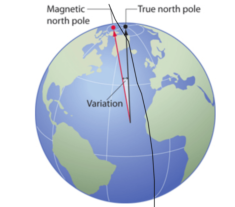
True North, also known as Geographic North or Geodetic North, is the fixed point on the Earth’s surface where the axis of rotation meets the crust. This is the North Pole. In terms of digital mapping and global positioning systems (GPS), True North serves as the static reference point for latitude and longitude grids. It is the absolute, unchanging north.
When you look at a digital map application like Google Maps or Apple Maps, the “top” of the screen typically aligns with True North. Software engineers use this as the master coordinate system because it provides a consistent, global standard that does not fluctuate over time, ensuring that data points placed on a digital map remain accurate regardless of external interference.
Magnetic North: The Dynamic Variable
Magnetic North is the point on the surface of the Earth’s Northern Hemisphere at which the planet’s magnetic field points vertically downward. Unlike True North, Magnetic North is not fixed. Because the Earth’s outer core consists of molten iron and nickel moving in complex, convective currents, the magnetic field is constantly shifting.
In the world of consumer electronics, the internal magnetometer—the sensor inside your smartphone that functions as a digital compass—detects this magnetic force. Because the magnetic poles move continuously, the “North” detected by your device’s hardware is in a state of constant drift. For software developers, this means that data gathered from sensors must be constantly recalibrated against the shifting reality of the magnetic field.
Integration Challenges in Software Development
The divergence between True North and Magnetic North creates a phenomenon known as “magnetic declination” or “magnetic variation.” This is the angle between the direction a compass needle points (Magnetic North) and the direction of the geographic North Pole (True North).
The Mathematical Correction: Magnetic Declination
When building apps that rely on compass orientation, developers cannot simply feed raw data from the magnetometer to the user. If an application displays a direction based solely on the raw magnetic reading without correcting for declination, the accuracy of the directional data will degrade the further the user is from an “agonic line”—a line where magnetic north and true north align.
To bridge this gap, software developers must incorporate the World Magnetic Model (WMM) or similar geomagnetic data sets into their code. These models calculate the estimated declination for any given latitude and longitude at a specific point in time. By applying this mathematical offset to the raw magnetic data, an application can output an orientation that correctly points the user toward True North, providing a seamless and intuitive navigation experience.
Hardware Limitations and Sensor Fusion
Modern mobile devices employ a technique called “Sensor Fusion” to provide reliable directional data. A smartphone does not rely on the magnetometer alone. To counteract the limitations of relying on Magnetic North, the operating system’s software stack fuses data from the gyroscope, accelerometer, and GPS.
The accelerometer helps determine the device’s tilt, the gyroscope tracks rotation, and the GPS tracks movement over time to establish a heading based on the path of travel. By combining these sensor inputs, the device can provide a “heading” that is much more stable than what a simple magnetic compass could provide. When developers build AR experiences or indoor navigation tools, they are essentially leveraging these complex software layers that resolve the conflict between magnetic interference and geodetic reality.
The Impact on Global Navigation Systems and Modern Apps
The importance of distinguishing between these two directional references extends deep into the infrastructure of our digital world. From autonomous vehicles to high-frequency trading servers that use atomic clock synchronization, the nuances of geographic orientation are critical.
Navigation Apps and AR Overlays
In augmented reality applications, such as those used for property visualization or gaming, the accuracy of the overlay depends entirely on the device’s ability to orient its virtual camera with the physical world. If a user is viewing a virtual building overlay through their phone screen, even a two-degree error caused by failing to account for magnetic declination will make the AR object appear disconnected from reality.
Software engineers building these tools must utilize real-time APIs that query the current magnetic variation based on the user’s GPS-verified location. By dynamically updating the “North” reference, the software ensures that the digital world stays locked to the physical world, maintaining the illusion of persistent spatial integration.
Indoor Positioning and Data Integrity
When GPS signals are unavailable—such as inside large shopping malls, tunnels, or subterranean infrastructure—applications often rely on “dead reckoning” using inertial sensors and compass headings. In these scenarios, the system is highly sensitive to the difference between True and Magnetic North.
If an indoor mapping system is pre-configured using blueprints aligned to True North, but the application is calculating the user’s movement based on magnetic heading without correction, the user’s digital avatar will eventually drift away from their actual physical position. This “positional drift” is a common technical hurdle that developers must overcome. Implementing a robust declination compensation algorithm is essential for maintaining accuracy in high-precision indoor environments, as even minor discrepancies can lead to significant navigation errors over a short distance.
Future-Proofing Digital Navigation
As technology progresses, the reliance on magnetic sensing may evolve, but the fundamental difference between the Earth’s physical axis and its shifting magnetic field will remain a primary constraint for developers.
The Role of Geodetic Data in Web 3.0 and IoT
With the rise of the Internet of Things (IoT) and the integration of spatial computing into the fabric of the web, accurate geographic referencing is becoming a commodity. Smart city sensors, drones, and autonomous delivery robots rely on high-fidelity geographic data to navigate physical spaces safely. These systems often operate on a dual-reference architecture: using GPS and GNSS (Global Navigation Satellite System) for high-level positioning and localized magnetic sensing for granular orientation.
Developers working in these fields must move beyond simple compass implementations. They are now tasked with creating adaptive software systems that can handle “magnetic noise”—interference from local metal structures, electrical conduits, and large urban environments that distort the local magnetic field. By understanding that Magnetic North is a localized, noisy signal and True North is a global, stable constant, architects of these systems can build more resilient, self-correcting algorithms.

Conclusion for the Digital Architect
Ultimately, the distinction between True North and Magnetic North is a lesson in the importance of context. In the digital realm, data is only as good as its reference point. Whether you are developing a basic utility app, a complex logistics platform, or an immersive AR experience, the accuracy of your directional output depends on your ability to synthesize disparate data streams.
By prioritizing the mathematical correction of magnetic declination and utilizing sophisticated sensor fusion, developers can provide users with the seamless, accurate navigation tools they expect. The gap between the magnetic pole and the geographic pole is, in essence, an opportunity for better software engineering—a chance to translate the erratic, shifting forces of the natural world into the precise, reliable digital experiences that define modern technology.
aViewFromTheCave is a participant in the Amazon Services LLC Associates Program, an affiliate advertising program designed to provide a means for sites to earn advertising fees by advertising and linking to Amazon.com. Amazon, the Amazon logo, AmazonSupply, and the AmazonSupply logo are trademarks of Amazon.com, Inc. or its affiliates. As an Amazon Associate we earn affiliate commissions from qualifying purchases.