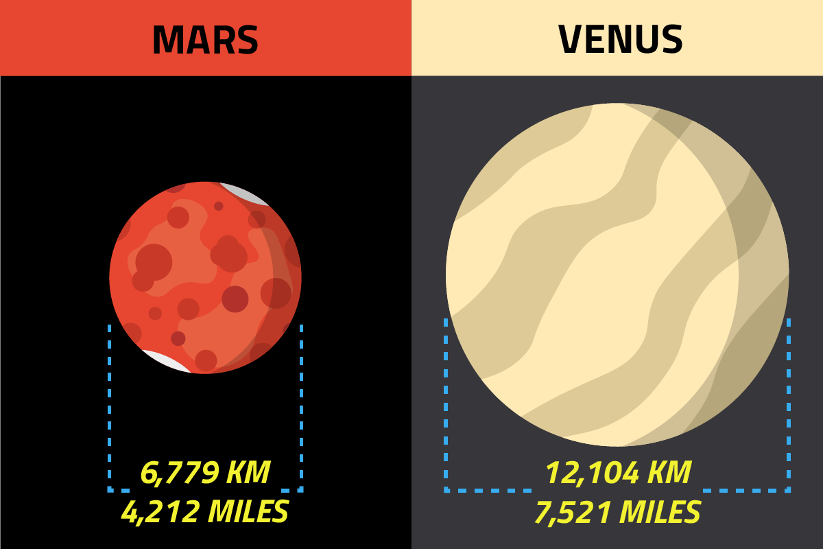
The Red Planet, Mars, a celestial neighbor captivating humanity for millennia, holds a specific and critical dimension: its diameter. Modern technology has allowed us to ascertain this figure with remarkable precision. The diameter of Mars is approximately 6,779 kilometers. This seemingly simple number, however, is a testament to centuries of scientific endeavor and, more recently, a dazzling array of technological advancements that continue to push the boundaries of space exploration and understanding. Far from being a mere astronomical fact, this measurement is a cornerstone for designing future missions, developing advanced exploration tools, and unraveling the solar system’s mysteries through cutting-edge tech.
The Technological Quest for Planetary Dimensions
Determining the precise dimensions of a distant celestial body like Mars is not a trivial task; it requires an intricate interplay of observational technology, computational power, and sophisticated data analysis. From the earliest telescopic observations to today’s multi-billion-dollar space probes, technology has been the relentless driver behind our increasingly accurate understanding of Mars’s physical characteristics.
Early Astronomical Instruments and Methodologies
Before the era of space probes, astronomers relied primarily on ground-based telescopes to measure planetary sizes. While revolutionary for their time, these instruments faced inherent limitations due to Earth’s atmosphere causing distortions and the vast distances involved. Techniques included measuring the angular diameter of Mars against known stellar backgrounds and calculating distance via parallax. Such measurements, though improving over centuries, were approximations heavily influenced by atmospheric conditions and instrument resolution. The advent of larger, more powerful optical telescopes, coupled with early photographic techniques, marked a significant step forward, allowing for more detailed visual data collection and initial estimates that hinted at Mars’s true scale.
The Rise of Space-Based Observatories
A monumental leap in precision came with the deployment of space-based observatories. Free from atmospheric interference, telescopes like the Hubble Space Telescope (HST) could capture Mars with unprecedented clarity. HST’s advanced imaging capabilities allowed for sharper resolution of Mars’s disk, enabling more accurate angular diameter measurements. Furthermore, its ability to observe across various wavelengths provided additional data points for modeling Mars’s shape and size. These space-based assets represent a paradigm shift, transforming astronomy from a solely ground-bound science to one that leverages orbital platforms as critical data collectors, laying the groundwork for even more direct measurement methods.
Space Probes: Precision Measurement through Robotic Emissaries
The ultimate technological advancement for determining planetary dimensions arrived with the launch of robotic space probes. These sophisticated spacecraft, equipped with an array of highly specialized instruments, have provided direct, in-situ measurements and high-resolution mapping, revolutionizing our understanding of Mars’s exact size and topography.
Orbiters and Their Advanced Instrumentation
Orbiting spacecraft, such as NASA’s Mars Reconnaissance Orbiter (MRO), Mars Odyssey, and ESA’s Mars Express, are engineering marvels designed for long-duration data collection. They circle Mars, systematically mapping its surface and atmospheric properties. Key instruments aboard these orbiters directly contribute to diameter determination:
- High-Resolution Cameras (e.g., HiRISE on MRO): These cameras capture incredibly detailed images of the Martian surface, allowing scientists to identify features and establish precise geographical coordinates. By mapping these features across the entire planet, and combining data from multiple orbits, the overall curvature and extent of the planet can be precisely modeled.
- Laser Altimeters (e.g., MOLA on Mars Global Surveyor, now defunct but foundational): Instruments like the Mars Orbiter Laser Altimeter (MOLA) played a critical role. MOLA bounced laser pulses off the Martian surface and measured the time it took for the light to return. By knowing the spacecraft’s orbital altitude and the speed of light, scientists could precisely calculate the surface elevation beneath the orbiter. Over thousands of orbits, MOLA created a detailed topographic map of Mars, from which its precise mean radius (and thus diameter) could be derived, accounting for variations in terrain. Modern altimeters continue to refine these measurements.
- Radio Science Experiments: By precisely tracking the radio signals exchanged between Earth and orbiting spacecraft, scientists can detect tiny variations in the spacecraft’s orbit caused by Mars’s gravitational field. These subtle changes provide crucial data about Mars’s mass distribution, which in turn helps refine models of its internal structure and overall shape, complementing surface elevation data.

These instruments, working in concert, provide a rich dataset that allows for the construction of highly accurate 3D models of Mars. The engineering behind these instruments — from precision optics to stable laser emitters and ultra-sensitive detectors — represents the pinnacle of modern technological achievement.
Data Transmission and Processing Technologies
The sheer volume of data generated by these probes is staggering. High-gain antennas on the spacecraft transmit gigabytes of information across millions of kilometers back to Earth. This requires advanced communication protocols, error correction algorithms, and robust ground station networks (like NASA’s Deep Space Network). Once received, this raw telemetry undergoes sophisticated processing. Specialized software stitches together thousands of individual images, corrects for orbital variations, integrates altimetry readings, and applies complex algorithms to filter noise and enhance signal quality. Without these advanced data handling and computational technologies, the vast streams of scientific data would remain unusable, and the precise diameter of Mars would remain elusive.
Data Science and Modeling: Refining Our Understanding
The raw data streamed back from space probes is just the beginning. The journey from scattered data points to a precise planetary diameter involves advanced data science, computational modeling, and increasingly, artificial intelligence.
Advanced Algorithms and Computational Models
Scientists employ sophisticated algorithms to integrate diverse datasets – optical images, laser altimetry, gravitational field data, and atmospheric measurements. Computational models are built to represent Mars’s shape as an oblate spheroid (a sphere slightly flattened at the poles due to rotation), accounting for its rotation rate and internal mass distribution. Iterative processes refine these models, continually adjusting parameters to best fit all available data. Techniques like spherical harmonics are used to describe the planet’s gravitational field and topography, allowing for a highly detailed representation of its shape and deviations from a perfect sphere. The processing power required to run these models and manage petabytes of data emphasizes the crucial role of high-performance computing in modern planetary science.
The Role of Artificial Intelligence and Machine Learning
The burgeoning fields of artificial intelligence (AI) and machine learning (ML) are increasingly being applied to astronomical data analysis, including planetary mapping. AI algorithms can autonomously process vast quantities of imagery to identify features, detect subtle changes over time, and even correct for instrument anomalies more efficiently than human analysts. ML models can be trained on existing datasets to predict terrain characteristics or identify regions of interest for future exploration. In the context of planetary dimensions, AI can assist in optimizing the stitching of surface maps, identifying inconsistencies in data from different instruments, and even improving the efficiency of data compression for transmission, ultimately leading to more robust and accurate diameter calculations. Predictive modeling, enhanced by AI, can also project how Mars’s shape might evolve over geological timescales, adding another layer of insight.
Why Knowing Mars’s Diameter Matters for Future Tech
The precise knowledge of Mars’s diameter, derived through cutting-edge technology, is far more than an academic curiosity; it is a fundamental piece of information critical for the design, planning, and execution of future space exploration missions and the development of next-generation space technology.
Mission Planning and Trajectory Design
For any mission to Mars, whether robotic or human, accurate planetary dimensions are indispensable. Trajectory planning for spacecraft entry, descent, and landing (EDL) relies heavily on these figures. The precise radius determines the altitude at which atmospheric braking begins, the required thrust for landing, and the exact coordinates for target landing sites. Errors in diameter calculation could lead to catastrophic mission failure. Furthermore, designing stable orbits for future Mars satellites or communication relays requires meticulous understanding of the planet’s gravitational field, which is intrinsically linked to its mass and precise shape derived from its diameter.
Designing Exploration Hardware and Habitats
As humanity looks towards sustained presence on Mars, knowing its diameter impacts the design of virtually every piece of hardware. Rovers and landers need to be engineered to traverse specific terrains and operate within the planet’s gravity, which is determined by its mass and radius. Future human habitats and infrastructure must be designed with an understanding of Martian gravity and topography for structural integrity and operational efficiency. The scale of the planet also informs resource mapping technologies; for example, technologies for detecting subsurface ice or minerals need to operate effectively over a known planetary surface area. Technologies for atmospheric entry, such as parachutes and aeroshells, are designed based on the planet’s size, mass, and atmospheric properties.
Robotics and Autonomous Systems for Martian Exploration
Advanced robotics and autonomous systems will be central to future Martian exploration. For these systems to navigate, map, and perform scientific tasks effectively, they require accurate digital elevation models and precise positioning relative to a known planetary reference frame, which originates from the planet’s fundamental dimensions. AI-powered navigation systems for rovers and drones, for instance, need to compute paths and avoid hazards using real-time sensor data correlated with high-fidelity 3D maps derived from altimetry and imaging data. The development of self-correcting AI for autonomous planetary operations is directly informed by our understanding of the precise physical environment, anchored by dimensions like the diameter. In essence, the diameter of Mars is not just a number; it’s a foundational data point enabling the next generation of interplanetary technological innovation.
aViewFromTheCave is a participant in the Amazon Services LLC Associates Program, an affiliate advertising program designed to provide a means for sites to earn advertising fees by advertising and linking to Amazon.com. Amazon, the Amazon logo, AmazonSupply, and the AmazonSupply logo are trademarks of Amazon.com, Inc. or its affiliates. As an Amazon Associate we earn affiliate commissions from qualifying purchases.