In the realm of meteorology and emergency management, language is a tool as critical as radar. When the National Weather Service (NWS) issues a “Particularly Dangerous Situation” (PDS) Tornado Warning, it isn’t merely a weather update; it is a high-level technological communication triggered by specific data thresholds. While a standard tornado warning indicates that a tornado is “indicated by radar” or “sighted by spotters,” a PDS warning represents a tier of urgency reserved for the most violent, life-threatening atmospheric events.
To understand what a PDS warning is, we must look beyond the sirens and delve into the sophisticated technological infrastructure—ranging from dual-polarization radar to machine learning algorithms—that allows meteorologists to identify these rare and catastrophic events with high confidence.
Understanding the PDS Designation: A Data-Driven Approach
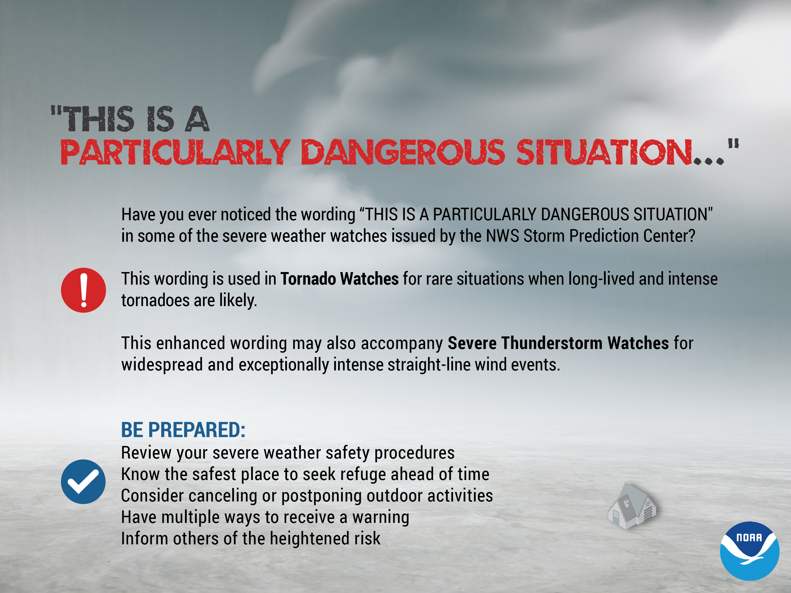
The “Particularly Dangerous Situation” (PDS) label is an enhanced wording used in NWS products. In the context of a tornado warning, it serves as a digital flag to signify that there is a high likelihood of a violent, long-track tornado that could cause “incredible” or “catastrophic” damage. From a technical standpoint, this is not a subjective call but a decision based on integrated data streams.
The Criteria for a Particularly Dangerous Situation
A PDS warning is typically triggered when meteorologists have “high confidence” of a significant threat. This confidence usually stems from two sources: ground-truth confirmation from storm spotters or, more commonly in the digital age, a “Tornado Debris Signature” (TDS) appearing on radar. When the software detects debris being lofted thousands of feet into the air, the threat level transitions from “radar-indicated” to “confirmed large and extremely dangerous.” This is the point where the PDS tag is applied to the metadata of the warning, alerting newsrooms and emergency apps to prioritize the notification.
How Digital Forecasting Models Identify High-End Risks
Before a PDS warning is ever issued, predictive tech is at work. High-Resolution Rapid Refresh (HRRR) models and the North American Mesoscale (NAM) models process millions of data points every hour. These models look for specific indices, such as high “Significant Tornado Parameter” (STP) values. When these digital models align with real-time observation, meteorologists can anticipate the “PDS” environment hours before the first cloud rotates, allowing for the pre-positioning of emergency tech and resources.
The Tech Stack of Modern Meteorology: Doppler Radar and Dual-Pol Technology
The backbone of any PDS warning is the NEXRAD (Next-Generation Radar) system. However, the shift from basic Doppler to “Dual-Polarization” (Dual-Pol) technology has been the single most important advancement in identifying PDS-level threats.
Evolution from Analog to Digital Radar
Traditional radar sent out horizontal pulses, measuring the intensity of precipitation. While effective, it struggled to differentiate between heavy rain, hail, and debris. Modern Dual-Pol radar sends both horizontal and vertical pulses. This allows the system to measure the size, shape, and orientation of objects in the sky. When a tornado strikes a populated area, it lofts debris—insulation, wood, metal—into the air. These objects are non-spherical and irregular, creating a specific digital signature known as a “Correlation Coefficient” (CC) drop.
Using Debris Signatures (TDS) to Confirm PDS Status
When a meteorologist sees a “velocity couplet” (intense rotation) co-located with a “debris ball” on the CC product, they have digital proof of a tornado on the ground causing damage. In the past, meteorologists had to wait for a phone call from a spotter to confirm a tornado. Today, the tech allows them to “see” the destruction in real-time on their monitors. This technological confirmation is what allows the NWS to issue a PDS warning with the confidence that it will not be a “false alarm,” thereby maintaining the credibility of the emergency alert system.
Artificial Intelligence and Machine Learning in Severe Weather Prediction

As the volume of data from satellites and radar stations increases, the human ability to process it in real-time is stretched to the limit. This is where Artificial Intelligence (AI) and Machine Learning (ML) are beginning to play a pivotal role in the issuance of PDS warnings.
Probabilistic Hazard Information (PHI) and Real-Time Analysis
The NOAA National Severe Storms Laboratory is currently testing a system called Forecasting a Continuum of Environmental Threats (FACETs). This tech uses AI to provide “Probabilistic Hazard Information.” Instead of a simple “yes/no” warning polygon, AI algorithms generate a probability grid that updates every minute. If the AI detects a 90% probability of a violent tornado based on historical pattern matching of supercell structures, it assists the meteorologist in deciding whether a PDS tag is warranted.
Neural Networks and Pattern Recognition in Supercells
Modern meteorology software employs neural networks trained on decades of radar data. These networks can identify the “Hook Echo” or the “Bounded Weak Echo Region” (BWER) with higher precision than ever before. By comparing real-time radar scans to thousands of past violent tornadoes (like the EF-5 Moore or Joplin events), the software can flag “signature” movements that precede a PDS event. This predictive tech buys precious minutes—sometimes up to 30 minutes of lead time—which is the difference between life and death in a PDS scenario.
The Digital Infrastructure of Emergency Alerting
Issuing a PDS warning is only half the battle; the other half is the technological dissemination of that warning to the public. The infrastructure involved in “getting the word out” is a complex web of satellite communication, cellular protocols, and API integrations.
Wireless Emergency Alerts (WEA) and Geospatial Targeting
Most people receive PDS warnings via their smartphones through the Wireless Emergency Alerts (WEA) system. This tech utilizes “geofencing” to send a specific signal to every cell tower within the warning polygon. Unlike a standard text message, WEA uses a dedicated radio channel to avoid network congestion. When a PDS warning is issued, the “imminent threat” alert level is used, which triggers a unique, high-decibel tone and vibration pattern on mobile devices, ensuring the user recognizes the gravity of the situation.
The Role of Social Media and API Integration in Rapid Dissemination
In the digital age, PDS warnings are instantly converted into various data formats (like JSON or XML) via the Integrated Public Alert and Warning System (IPAWS). This data is then consumed by APIs for social media bots, weather apps, and automated broadcast systems. Within seconds of a meteorologist hitting “send,” the PDS warning is live on Twitter, localized weather apps, and “crawls” across digital television screens. This automated pipeline removes human latency from the communication chain.
Future Innovations: The Next Generation of Tornado Detection Technology
While our current tech is impressive, the goal is to reach a “Zero Lead Time” failure rate for PDS events. New technologies currently in the prototype phase promise to make tornado warnings even more precise and localized.
Phased Array Radar (PAR) and its Impact on Warning Times
One of the limitations of current NEXRAD radar is that the dish must physically rotate, taking about 4 to 5 minutes to complete a full scan of the atmosphere. In a rapidly evolving PDS situation, a tornado can form and dissipate between scans. Phased Array Radar (PAR)—technology borrowed from the defense industry’s missile tracking systems—uses stationary panels that scan the sky electronically. This allows for a full scan in less than 60 seconds. With PAR, meteorologists can watch a tornado’s lifecycle in high-definition, providing a smoother and more accurate data stream for PDS warnings.
Integrating IoT and Smart Home Tech for Enhanced Safety
The future of PDS warnings lies in the “Internet of Things” (IoT). Imagine a scenario where a PDS warning is issued, and your smart home automatically responds: the lights turn red to signal danger, your smart speakers broadcast the latest NWS audio, and your smart thermostat shuts off the HVAC system to prevent the spread of fire or gas in the event of structural damage. Tech companies are already exploring how to integrate NWS data streams into smart home hubs to ensure that even if a person is sleeping or away from their phone, the house itself acts as an early warning system.
Conclusion
A “PDS Tornado Warning” is the intersection of atmospheric science and cutting-edge technology. It represents the pinnacle of our current ability to monitor the planet’s most violent forces. Through the use of Dual-Pol radar, AI-driven predictive modeling, and a robust digital alert infrastructure, we have moved from a world of “duck and cover” to a world of “detect and notify.” As we continue to refine Phased Array Radar and IoT integrations, the PDS warning will become an even more surgical tool, providing the digital “shield” necessary to save lives in the face of nature’s most “particularly dangerous” moments.
aViewFromTheCave is a participant in the Amazon Services LLC Associates Program, an affiliate advertising program designed to provide a means for sites to earn advertising fees by advertising and linking to Amazon.com. Amazon, the Amazon logo, AmazonSupply, and the AmazonSupply logo are trademarks of Amazon.com, Inc. or its affiliates. As an Amazon Associate we earn affiliate commissions from qualifying purchases.