
Understanding your home’s elevation can be crucial for a variety of reasons, from assessing potential flood risks and planning construction projects to simply satisfying curiosity about your property’s geographical standing. Fortunately, the advancement of technology has made determining this precise measurement more accessible than ever, moving beyond expensive professional surveys to a realm of intuitive online tools, mobile applications, and sophisticated digital mapping services. This guide delves into the technological landscape available to homeowners, outlining how to leverage these digital and physical tools to accurately ascertain your home’s elevation.
Why Leveraging Technology for Elevation Data is Essential
The question of “what is my home’s elevation” isn’t merely academic. For many, it’s a practical inquiry with significant implications. For instance, flood zone determinations often rely on precise elevation data relative to sea level or local benchmarks. Construction projects, especially those involving significant grading or drainage, demand accurate topographical information. Even understanding microclimates or solar panel efficiency can subtly link back to a property’s elevation and orientation.
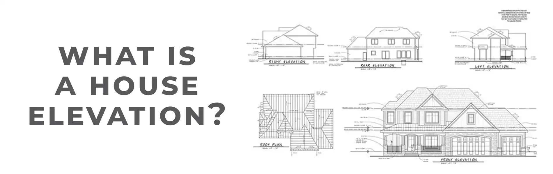
Before the digital age, obtaining this data typically required hiring a land surveyor—a costly and time-consuming endeavor. Today, Geographic Information Systems (GIS), satellite technology, and advanced algorithms have democratized access to elevation data, placing powerful tools directly into the hands of homeowners. These technologies provide not only the raw numbers but also contextual maps and analytical capabilities, transforming a complex surveying task into a readily achievable digital query.
Leveraging Online Tools for Instant Elevation Data
The internet offers a wealth of resources for determining your home’s elevation with varying degrees of accuracy. These tools typically utilize publicly available Digital Elevation Models (DEMs), which are raster-based files where each pixel represents an elevation value for a specific area.
Web-Based Topographic Map Viewers
Many government agencies and private mapping services provide online viewers that integrate DEMs with satellite imagery and street maps. These platforms allow users to zoom into a specific location and often display elevation contours or point-specific elevation readings.
- How They Work: These viewers pull data from global or regional DEMs, such as those derived from Shuttle Radar Topography Mission (SRTM) data or LiDAR (Light Detection and Ranging) scans. When you click or hover over a spot on the map, the system queries its underlying elevation database and displays the corresponding value.
- Key Features: Look for tools that offer a draggable pin, allowing you to precisely pinpoint your home’s foundation or specific points on your property. Many also provide elevation profiles along a drawn path, offering insight into the slope and undulation of surrounding terrain.
- Accuracy Considerations: The resolution of the underlying DEM is paramount. Some global DEMs might have a resolution of 30 meters or more, meaning the elevation value represents an average over a 30×30 meter square. Higher-resolution LiDAR-derived DEMs, often available from local or state government portals, can offer sub-meter accuracy, which is significantly more precise for specific property analysis.
Dedicated Elevation Finder Websites
Beyond general mapping services, numerous websites are specifically designed to provide elevation data. These often streamline the process, requiring only an address or GPS coordinates to return an elevation reading.
- How They Work: These sites typically interface with APIs (Application Programming Interfaces) from major mapping providers (like Google Maps or OpenStreetMap) to locate the address, and then cross-reference that location with a chosen DEM source. Some might aggregate data from multiple sources to provide a composite or averaged reading.
- User Interface: Simplicity is a hallmark. Input your address, and the site generates a map with your location marked, often displaying the elevation prominently. Some even allow for dynamic measurement by moving a cursor or pin across the map.
- Comparative Analysis: It’s often insightful to use two or three different elevation finder websites. While they might pull from similar underlying DEMs, slight variations can occur due to interpolation methods, the specific DEM version used, or how they define “sea level” (orthometric vs. ellipsoidal height). This comparison can give you a range of plausible elevations.
Mobile Apps: Elevation at Your Fingertips
Smartphones have become powerful portable tools for environmental data, and elevation is no exception. With built-in GPS capabilities and access to vast data networks, mobile apps offer convenient and often surprisingly accurate elevation readings on the go.
GPS-Enabled Elevation Apps
Many apps are specifically designed to measure and display your current elevation, using your phone’s internal GPS receiver.
- How They Work: Your smartphone’s GPS receiver calculates your position in three dimensions (latitude, longitude, and altitude) by triangulating signals from multiple satellites. These apps then interpret this raw GPS altitude data.
- Enhancing Accuracy: Raw GPS altitude (ellipsoidal height) is often less accurate than horizontal position and can drift. Many sophisticated elevation apps improve accuracy by:
- Barometric Altimeter Integration: Modern smartphones often include a barometric pressure sensor. Since atmospheric pressure decreases with altitude, apps can combine GPS data with barometric readings for more stable and precise elevation. This is particularly useful for relative changes in elevation (e.g., hiking), but still needs calibration for absolute elevation.
- DEM Referencing: Some apps cross-reference your GPS-derived location with stored or online DEMs to provide an orthometric (mean sea level) height, which is generally more relevant for real-world applications like flood plains.
- Network Assisted GPS (A-GPS): By using cellular tower and Wi-Fi network data in addition to satellite signals, A-GPS can speed up initial positioning and improve accuracy, especially in urban environments where satellite signals might be obstructed.
- Features to Look For:
- Real-time updates: Essential for tracking elevation changes as you move.
- Map integration: Visualizing your elevation on a map, often with contour lines.
- Data logging: Recording elevation profiles over time or distance.
- User calibration: The ability to manually input a known elevation point to calibrate the barometric altimeter for improved absolute accuracy.
Integrating Mapping Apps for Elevation Insights

Popular mapping applications, such as Google Maps or Apple Maps, while not primarily dedicated elevation tools, can often provide elevation insights through their advanced features.
- Google Earth Pro: The desktop version (free to download) offers a highly detailed 3D globe. By hovering your mouse over any point, you can see its elevation displayed in the status bar. It leverages high-resolution satellite imagery and extensive DEMs, making it a powerful visual tool for understanding terrain. The mobile app version may offer similar, though often less precise, features.
- Specialized Topo Apps: Apps designed for hikers, cyclists, and outdoor enthusiasts often incorporate detailed topographic maps with elevation contours. While primarily for navigation, they can be excellent for obtaining elevation data for your property within the context of its surrounding terrain. These apps often allow offline map downloads, making them useful even without a cellular signal.
Beyond Digital: Physical Devices and Professional Services
While digital tools offer immense convenience, there are situations where physical devices or professional expertise still hold an advantage, particularly concerning extreme precision or official documentation. These also leverage advanced technology.
Altimeters and Handheld GPS Devices
Dedicated altimeters and GPS devices, especially those designed for surveying or serious outdoor activities, often offer higher accuracy than a typical smartphone.
- How They Work:
- Barometric Altimeters: These devices measure air pressure to determine altitude. They require calibration against a known elevation point or regular updates with local weather station pressure for optimal accuracy, as pressure changes with weather.
- High-Precision GPS Devices: Unlike consumer-grade smartphone GPS, professional-grade handheld GPS units often employ dual-frequency receivers, advanced signal processing, and differential GPS (DGPS) or Real-Time Kinematic (RTK) corrections. DGPS uses a network of fixed, ground-based reference stations to broadcast correction data to GPS receivers, significantly improving accuracy. RTK takes this further, providing centimeter-level precision in real-time.
- When to Use: For detailed land surveys, determining foundation elevations for construction, or when smartphone signal/accuracy is insufficient, these devices offer a robust solution. They are also rugged and designed for field use.
Surveying Professionals (Leveraging Cutting-Edge Technology)
For legally binding elevation certificates, detailed flood plain analysis, or complex construction projects, a licensed land surveyor remains the gold standard. They employ sophisticated, highly accurate technological instruments.
- How They Work: Surveyors use advanced equipment like total stations, robotic total stations, and specialized GNSS (Global Navigation Satellite System) receivers.
- Total Stations: These optical instruments measure angles and distances to provide precise coordinate data for points on the ground. Modern total stations are electronic and often integrate with computer software for data processing.
- GNSS Receivers: High-end GNSS receivers (which include GPS, GLONASS, Galileo, BeiDou) used by surveyors are far more sensitive and accurate than consumer GPS. They often operate in conjunction with RTK or PPK (Post-Processed Kinematic) techniques, utilizing ground base stations or networked corrections to achieve centimeter to millimeter accuracy.
- LiDAR Scanners: For large-area mapping or highly detailed 3D models of properties, surveyors may employ terrestrial LiDAR scanners which use pulsed laser light to measure distances and create extremely dense point clouds representing the ground and features.
- When to Use: When official documentation (e.g., for flood insurance), legal disputes, or projects requiring sub-inch accuracy are involved, the investment in a professional surveyor is warranted. Their technology and expertise provide the highest level of precision and reliability.
Understanding Elevation Accuracy and Limitations
While technology offers unprecedented access to elevation data, it’s crucial to understand the nuances of accuracy and the limitations inherent in different methods.
Factors Affecting GPS Precision
The accuracy of GPS-derived elevation, whether from a smartphone or a handheld device, can be influenced by several factors:
- Satellite Availability and Geometry: The more satellites in view and the better their geometric distribution, the more accurate the position fix (including altitude). Obstructions like buildings, dense tree cover, or steep terrain can reduce visible satellites and degrade accuracy.
- Atmospheric Conditions: The Earth’s atmosphere (ionosphere and troposphere) can delay GPS signals, introducing errors. Dual-frequency receivers and atmospheric models help mitigate this.
- Multipath Error: When GPS signals bounce off surfaces (buildings, ground) before reaching the receiver, they can arrive via multiple paths, confusing the receiver and leading to incorrect position calculations.
- GPS vs. Orthometric Height: GPS receivers inherently calculate an “ellipsoidal height” relative to an idealized mathematical model of the Earth (an ellipsoid). Most practical applications, however, require “orthometric height,” which is elevation above mean sea level (geoid). The difference between the ellipsoid and the geoid varies across the Earth. Many online tools and apps automatically apply a geoid model to convert ellipsoidal to orthometric height, but the accuracy of this conversion can vary.
Data Source Reliability and Resolution
The underlying DEMs that online tools and many apps rely upon vary significantly in their resolution and vintage.
- Resolution: A 1-meter DEM will provide far more localized detail than a 30-meter DEM. Using a low-resolution DEM for a small property might average out significant local variations, leading to a less representative elevation.
- Data Age: Elevation data might be several years old. While natural processes like erosion or geological shifts are generally slow, human alterations (construction, grading, mining) can significantly change local elevation. Always check the data source’s metadata for acquisition dates if available.
- Vertical Datum: Ensure that the elevation data you are comparing or using is referenced to the same vertical datum (e.g., NAVD88, NGVD29). Mixing datums without proper conversion can lead to discrepancies.
By understanding the technological underpinnings and limitations, homeowners can effectively utilize the array of digital tools and services to accurately determine their home’s elevation, empowering informed decisions about their property.
aViewFromTheCave is a participant in the Amazon Services LLC Associates Program, an affiliate advertising program designed to provide a means for sites to earn advertising fees by advertising and linking to Amazon.com. Amazon, the Amazon logo, AmazonSupply, and the AmazonSupply logo are trademarks of Amazon.com, Inc. or its affiliates. As an Amazon Associate we earn affiliate commissions from qualifying purchases.