
Geospatial Information Systems (GIS) represent a powerful technological framework that bridges the gap between the physical world and the digital realm. At its core, GIS is a system designed to capture, store, manipulate, analyze, manage, and present all types of geographically referenced data. This means GIS deals with information that has a location – whether it’s a specific address, a city, a country, or even a broader geographical feature like a mountain range or an ocean. In essence, GIS allows us to visualize, understand, question, interpret, and visualize data in ways that reveal relationships, patterns, and trends in the form of maps, globes, reports, and charts. It’s not merely about creating maps; it’s about using spatial data to solve complex problems and make better decisions across a vast array of industries and applications.
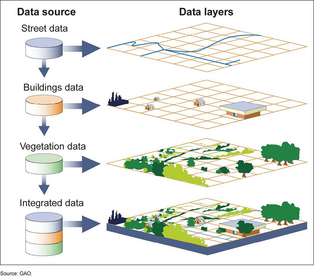
The Fundamental Building Blocks of GIS
Understanding what GIS is necessitates a grasp of its core components. These elements work in concert to enable the sophisticated analysis and visualization of spatial data. Without these foundational pieces, the power of GIS would remain largely untapped.
Data: The Spatial Foundation
The lifeblood of any GIS is its data. This data can be broadly categorized into two main types: spatial data and attribute data.
Spatial Data: Where Things Are
Spatial data describes the geographic location and shape of geographic features. This is the defining characteristic of GIS, providing the “where” to the information. Spatial data is typically represented in two primary formats: vector and raster.
-
Vector Data: This format uses discrete geometric shapes—points, lines, and polygons—to represent geographic features. Points are used for singular locations (e.g., a well, a street light, a city). Lines represent linear features (e.g., roads, rivers, power lines). Polygons represent areas with defined boundaries (e.g., lakes, buildings, administrative districts). The advantage of vector data is its precision and its ability to store detailed information about individual features. For instance, a point representing a city could have attributes like population, name, and elevation. A line representing a road could store its name, speed limit, and surface type.
-
Raster Data: This format represents the world as a grid of cells, also known as pixels. Each cell has a value that represents a characteristic of that location, such as temperature, elevation, or land cover type. Satellite imagery and aerial photographs are classic examples of raster data. Raster data is excellent for representing continuous phenomena that vary across space, like rainfall, temperature, or elevation. The resolution of the raster grid (the size of each cell) determines the level of detail; finer resolutions capture more detail but result in larger file sizes.
Attribute Data: What Things Are
Attribute data provides descriptive information about the spatial features. It’s the “what” associated with the “where.” For example, if a point represents a school, its attribute data might include the school’s name, address, number of students, and principal’s name. This data is typically stored in tables, where each row corresponds to a spatial feature and each column represents an attribute. The power of GIS lies in its ability to link spatial data with attribute data, allowing for complex queries and analyses. You can ask questions like, “Show me all schools within a 5-mile radius of a new park” or “Identify all residential areas with a population density exceeding 1,000 people per square mile.”
Hardware and Software: The Enabling Tools
GIS functionality is delivered through specialized hardware and software.
GIS Software: The Engine of Analysis
GIS software provides the tools and interface for users to work with geospatial data. This includes functions for data input and editing, data management, spatial analysis, and the creation of maps and visualizations. Prominent GIS software platforms include ArcGIS (from Esri), QGIS (an open-source option), and GRASS GIS (another open-source powerhouse). These software packages offer a wide range of capabilities, from basic map creation to advanced spatial modeling and data manipulation. They enable users to:
- Visualize Data: Displaying spatial data on maps, allowing for intuitive understanding of geographic patterns.
- Edit and Create Data: Digitizing new features from aerial imagery or creating new spatial datasets.
- Query and Analyze Data: Asking complex questions of the data, such as finding locations that meet specific criteria, measuring distances and areas, or identifying spatial relationships.
- Geoprocessing: Performing a variety of spatial operations, like buffering (creating zones around features), overlaying layers, or reclassifying data based on certain rules.
- Map Production: Designing and generating high-quality maps for reports, presentations, and public dissemination.
Hardware: The Physical Infrastructure
While GIS software is crucial, the underlying hardware is equally important. This includes powerful computers with sufficient processing power and memory to handle large datasets, high-resolution displays for accurate visualization, and potentially specialized input devices like GPS receivers and scanners for data capture. The performance of GIS operations is directly tied to the capabilities of the hardware.
People and Procedures: The Human Element
GIS is not just about technology; it’s also about the people who use it and the workflows they follow.
GIS Professionals: The Architects of Spatial Insight
GIS professionals, such as GIS analysts, technicians, and developers, are responsible for designing, implementing, and maintaining GIS systems. They are skilled in data management, spatial analysis, cartography, and often programming. Their expertise is vital for extracting meaningful insights from geospatial data and applying them to solve real-world problems.
Methodologies and Workflows: The Operational Framework
Established methodologies and standardized procedures are essential for ensuring the accuracy, consistency, and efficiency of GIS operations. This includes data collection protocols, quality control measures, and best practices for spatial analysis and map design. Without these frameworks, GIS projects can become unmanageable and unreliable.
The Power of Spatial Analysis in GIS
The true strength of GIS lies in its ability to perform spatial analysis, allowing users to uncover hidden patterns and relationships within geographic data. This goes far beyond simply displaying information on a map; it involves using sophisticated techniques to derive new insights and support decision-making.
Understanding Spatial Relationships
Spatial analysis techniques allow us to understand how different geographic features relate to each other in space. This can involve identifying proximity, connectivity, and spatial overlap.
Proximity Analysis: Measuring “Nearness”
Proximity analysis, often performed using buffering, helps us understand what is near what. For example, a buffer around a river might identify all properties within a certain distance of that river, crucial for flood plain management. Similarly, buffering a proposed retail store location can identify all residential areas within a 5-minute drive, aiding in market analysis.
Overlay Analysis: Combining Geographic Information
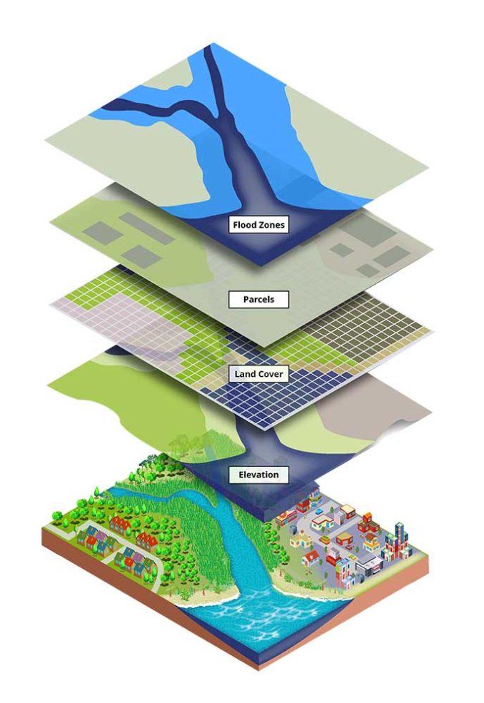
Overlay analysis is a fundamental technique where two or more layers of spatial data are combined to create a new dataset that incorporates the information from the original layers. This is incredibly powerful for identifying areas that meet multiple criteria. For instance, to find suitable locations for a new school, one might overlay layers of population density, existing school locations, and zoning regulations to identify areas with high demand and appropriate land availability.
Network Analysis: Navigating and Optimizing Routes
Network analysis is specifically designed for analyzing linear networks, such as road systems or utility lines. It can be used to find the shortest or fastest route between two points, identify the service areas of facilities (e.g., fire stations or hospitals), or determine the optimal placement of resources. This is critical for logistics, emergency response, and urban planning.

Identifying Patterns and Trends
GIS enables the identification of spatial patterns and trends that might otherwise go unnoticed.
Spatial Statistics: Quantifying Geographic Distributions
Spatial statistics techniques help us understand the distribution of phenomena across space. This can include identifying clusters of disease outbreaks, analyzing the spatial autocorrelation of environmental data, or determining if a pattern is random, clustered, or dispersed.
Geostatistics: Modeling Continuous Phenomena
Geostatistics, a specialized branch of spatial statistics, is used to model and analyze spatially continuous phenomena. Techniques like kriging are employed to estimate values at unmeasured locations based on known values, allowing for the creation of continuous surfaces representing things like soil salinity or groundwater contamination levels.
Predictive Modeling and Scenario Planning
GIS can be used to build models that predict future outcomes based on current spatial data and trends.
Suitability Analysis: Finding the Best Locations
Suitability analysis combines various spatial criteria to identify the most appropriate locations for a specific purpose. This is used in everything from selecting sites for renewable energy installations to planning agricultural land use. By weighting different factors (e.g., slope, soil type, proximity to infrastructure), GIS can rank potential sites based on their suitability.
Simulation and Forecasting: Visualizing Future Landscapes
GIS can be used to simulate the impact of various events or policy changes on the landscape. For example, models can be built to predict the spread of wildfires, the impact of sea-level rise on coastal communities, or the potential growth of urban areas. This foresight is invaluable for proactive planning and risk mitigation.
Applications of GIS Across Industries
The versatility of GIS means it is applied in virtually every sector imaginable, transforming how organizations operate and make decisions.
Environmental Management and Conservation
GIS plays a crucial role in understanding and protecting our environment. It aids in tracking deforestation, mapping pollution sources, monitoring wildlife habitats, and assessing the impact of climate change. For example, conservation organizations use GIS to identify critical habitats for endangered species and plan wildlife corridors. Environmental agencies use it to monitor compliance with regulations and respond to environmental disasters.
Urban Planning and Development
Cities worldwide rely on GIS for effective urban planning. It helps in zoning, infrastructure development, transportation planning, and emergency management. City planners use GIS to analyze population growth, identify areas for new housing or commercial development, optimize public transport routes, and plan for the efficient delivery of services like water and electricity. Its ability to visualize proposed developments against existing infrastructure is invaluable for informed decision-making.
Public Safety and Emergency Services
In critical situations, GIS is a life-saving tool. It supports emergency response by mapping incident locations, optimizing dispatch routes, and identifying vulnerable populations. During natural disasters like floods or earthquakes, GIS helps assess damage, coordinate rescue efforts, and allocate resources effectively. Law enforcement agencies use GIS for crime mapping and analysis, identifying patterns and deploying resources more efficiently.
Transportation and Logistics
The transportation industry leverages GIS for route optimization, fleet management, and infrastructure planning. Logistics companies use it to minimize delivery times and fuel costs, while transportation authorities use it to plan new roads, bridges, and public transit systems. Understanding traffic patterns and optimizing routes is paramount for efficiency and cost savings in this sector.
Agriculture and Resource Management
Modern agriculture benefits immensely from GIS through precision farming techniques. It allows farmers to analyze soil conditions, optimize irrigation and fertilization, and monitor crop health on a field-by-field basis. Resource managers use GIS to inventory and manage forests, water resources, and mineral deposits, ensuring sustainable extraction and utilization.
Business and Marketing
Businesses use GIS for site selection, market analysis, and customer segmentation. Retailers can identify prime locations for new stores based on demographic data and competitor analysis. Marketing teams can use GIS to target specific customer demographics within geographical areas, optimizing advertising campaigns and improving customer outreach. Understanding where your customers are and how to reach them is a key competitive advantage.
The Future of Geospatial Information Systems
The field of GIS is continually evolving, driven by advancements in technology and an ever-increasing demand for spatial insights.
Integration with Big Data and AI
The convergence of GIS with big data analytics and artificial intelligence (AI) is opening up new frontiers. AI algorithms can analyze vast geospatial datasets to identify complex patterns and make predictions with unprecedented accuracy. Machine learning models can automate tasks like feature extraction from satellite imagery, significantly accelerating data processing and analysis. This integration promises more intelligent and responsive spatial decision-making.
Real-Time Data and Cloud Computing
The ability to access and analyze real-time geospatial data is becoming increasingly important. With the rise of IoT devices and widespread sensor networks, GIS is moving towards real-time monitoring and analysis. Cloud computing platforms are providing scalable infrastructure and accessible tools, democratizing GIS and making powerful spatial analysis capabilities available to a broader range of users and organizations, regardless of their IT infrastructure.
Enhanced Visualization and Interactivity
Future GIS will offer even more immersive and interactive visualization experiences. Advancements in augmented reality (AR) and virtual reality (VR) will allow users to interact with geospatial data in 3D environments, providing deeper insights and more intuitive understanding. Web-based GIS applications are becoming more sophisticated, enabling seamless sharing and collaboration on spatial projects globally.
In conclusion, Geospatial Information Systems are a transformative technology that empowers us to understand and interact with the world around us in fundamentally new ways. By integrating location-based data with powerful analytical tools, GIS provides the foundation for informed decision-making, efficient resource management, and innovative problem-solving across a multitude of disciplines. As technology continues to advance, the capabilities and impact of GIS are set to grow exponentially, shaping our understanding of the planet and our place within it.
aViewFromTheCave is a participant in the Amazon Services LLC Associates Program, an affiliate advertising program designed to provide a means for sites to earn advertising fees by advertising and linking to Amazon.com. Amazon, the Amazon logo, AmazonSupply, and the AmazonSupply logo are trademarks of Amazon.com, Inc. or its affiliates. As an Amazon Associate we earn affiliate commissions from qualifying purchases.