
Controlled Traffic Farming (CTF) represents one of the most significant shifts in agricultural engineering and precision technology over the last few decades. At its core, CTF is a high-tech management system designed to minimize soil damage caused by heavy machinery. By confining all field vehicle wheels to the fewest possible permanent tracks, CTF creates a clear distinction between the “road” (where the machines drive) and the “bed” (where the crops grow).
While traditional farming treats the entire field as a surface to be driven upon, CTF utilizes advanced geospatial technology to ensure that up to 80-90% of a field remains completely untouched by heavy tires. This technological intervention is not merely a matter of driving in straight lines; it is a complex integration of satellite positioning, mechanical standardization, and data analytics aimed at optimizing the physical environment for plant growth.
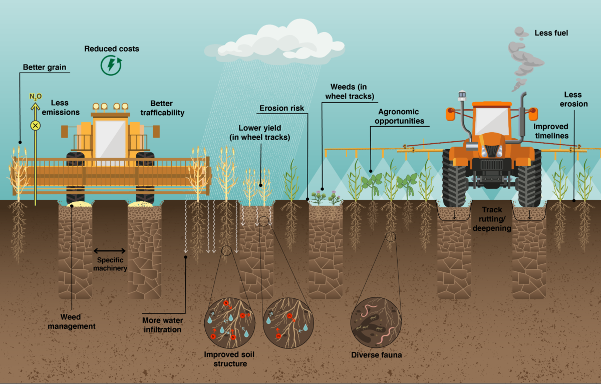
The Technological Infrastructure of Controlled Traffic Farming
The implementation of CTF is impossible without a robust suite of hardware and software solutions. It is a discipline of AgTech that requires high levels of precision, often down to the centimeter. Unlike standard GPS systems found in consumer vehicles, which may have a margin of error of several meters, CTF demands a level of accuracy that only specialized agricultural technologies can provide.
GNSS and RTK Connectivity
The backbone of any CTF system is Global Navigation Satellite System (GNSS) technology, specifically enhanced by Real-Time Kinematic (RTK) positioning. RTK technology uses a ground-based reference station to provide corrections to the satellite signals received by the tractor or harvester. This allows for “pass-to-pass” accuracy of approximately 2 centimeters.
This level of precision is critical because the entire concept of CTF relies on repeatability. A machine must be able to return to the exact same tracks season after season, year after year. Without RTK, the “drift” inherent in standard satellite signals would cause machinery to slowly encroach upon the crop zones, defeating the purpose of the permanent traffic lanes.
Machinery Standardization and Tracking Widths
One of the greatest technical hurdles in CTF is the synchronization of machinery widths. In a non-CTF environment, a farmer might use a 3-meter seeder, a 24-meter sprayer, and a 9-meter harvester. In a controlled traffic system, these widths must be mathematically compatible—often referred to as “the modular approach.”
Engineers must modify the “track gauge” (the distance between the wheels) of various implements so they all fit into the same permanent lanes. This often involves the use of axle extensions for tractors or specialized headers for combines. The software side of this equation involves sophisticated path-planning algorithms that calculate the most efficient route for all machines to ensure they never deviate from the designated digital map of the field.
Software Integration and Digital Mapping
Modern CTF is managed through centralized Farm Management Information Systems (FMIS). Before a single seed is planted, a digital “master plan” of the field is created. This map dictates every movement the machinery will make for the next decade. These digital lines are uploaded into the autosteer systems of every vehicle in the fleet, ensuring a unified operational language across different brands and types of equipment.
Solving the Soil Compaction Crisis Through Engineering
The primary technical objective of CTF is the mitigation of soil compaction. To understand why this is a tech-heavy endeavor, one must look at the physics of soil. When a heavy machine drives over soil, it collapses the macropores—the tiny gaps that hold air and water. This results in “pancaked” soil that roots cannot penetrate and water cannot infiltrate.
The Physics of Random Traffic vs. Controlled Lanes
In traditional “random traffic” farming, studies show that heavy machinery can cover up to 85% of a field’s surface in a single season. From a technical perspective, this is highly inefficient. It means the soil is being constantly “re-damaged,” requiring more energy (fuel) to till and break up the hardpan created by the tires.

By using CTF, the compaction is localized to specific “tramlines.” These lanes actually benefit from being compacted; they become hard, permanent “underground roads” that provide better traction. This reduces rolling resistance, meaning the tractor requires less power and fuel to move across the field. The tech essentially optimizes the field surface for two different functions: high-density paths for transport and low-density zones for biological production.
Remote Sensing and Soil Health Analytics
To measure the success of a CTF system, technologists use a variety of remote sensing tools. Normalized Difference Vegetation Index (NDVI) sensors mounted on drones or satellites can visually demonstrate the difference between CTF fields and traditionally managed ones. In a CTF system, crop growth is remarkably uniform because the soil structure is consistent across the entire “bed.”
Furthermore, soil moisture sensors and telemetry data provide real-time feedback on how the uncompacted soil is performing. Data often shows that uncompacted CTF soils have significantly higher water-holding capacity, reducing the technological load on irrigation systems and increasing the farm’s resilience to climate variability.
Automation, AI, and the Future of Field Operations
As we look toward the next generation of agriculture, Controlled Traffic Farming is becoming the prerequisite for full farm automation. Artificial Intelligence (AI) and autonomous robotics thrive in environments with high degrees of predictability—and CTF provides exactly that.
Autonomous Navigation Systems
The transition from “driver-assist” to “fully autonomous” is much easier in a CTF framework. Because the paths are digitally “locked,” an autonomous tractor does not need to “decide” where to go; it simply follows the high-precision RTK path programmed into its logic board. Computer vision and LiDAR (Light Detection and Ranging) are used as secondary safety layers to detect obstacles, but the primary navigation is a direct evolution of CTF’s digital mapping.
Telemetry and Real-Time Optimization
Modern CTF-enabled machinery is a rolling data center. Every pass over the field generates millions of data points regarding fuel consumption, engine load, and wheel slip. Because the machines are always on the same tracks, this data is highly comparable year-over-year.
AI algorithms can analyze this telemetry to optimize “workability windows.” For instance, because CTF tracks are hard and stable, they can support the weight of machinery even when the rest of the field is too wet to drive on. Software can predict exactly when a farmer can enter a field without getting stuck, a technical advantage that “random traffic” farmers simply do not have.
Integration with the Broader AgTech Ecosystem
Controlled Traffic Farming does not exist in a vacuum; it acts as a foundational layer for other precision technologies. When the physical location of every plant and every wheel track is known to a high degree of certainty, other tech-driven practices become much more effective.
Variable Rate Application (VRA)
Variable Rate Application allows farmers to apply fertilizer, chemicals, and seeds at different rates across a field based on digital maps. In a CTF system, VRA becomes even more precise. Since the soil health is more uniform (due to the lack of random compaction), the algorithms used to calculate nutrient requirements become more accurate. The “noise” in the data caused by soil compaction variables is removed, allowing for more surgical applications of inputs.
The Rise of Swarm Robotics
The future of CTF may see a shift from massive, heavy tractors to “swarms” of smaller, autonomous robots. However, the principle of controlled traffic remains vital. Even small robots can cause compaction over time if they wander aimlessly. Future CTF systems will likely involve fleets of lightweight robots programmed to follow the same digital “highways” established by their larger predecessors. These robots will communicate via 5G or local mesh networks to coordinate their movements, ensuring that the crop beds remain a “no-go zone” for wheels of any size.

Conclusion: The Digital Transformation of the Field
Controlled Traffic Farming is the ultimate marriage of mechanical engineering and spatial data science. It transforms the farm from a chaotic, variable environment into a structured, digitalized production facility. By leveraging GNSS, RTK, and advanced path-planning software, CTF allows farmers to manage their soil with the same precision that a silicon chip manufacturer manages a clean room.
As global populations rise and the pressure on arable land increases, the technological efficiency provided by CTF will transition from a “high-tech luxury” to an industry standard. It proves that the most effective way to improve biological yields is through the rigorous application of precision technology to the very ground we walk on. In the world of AgTech, CTF is not just about driving; it is about creating a permanent, digital, and physical architecture for the future of food production.
aViewFromTheCave is a participant in the Amazon Services LLC Associates Program, an affiliate advertising program designed to provide a means for sites to earn advertising fees by advertising and linking to Amazon.com. Amazon, the Amazon logo, AmazonSupply, and the AmazonSupply logo are trademarks of Amazon.com, Inc. or its affiliates. As an Amazon Associate we earn affiliate commissions from qualifying purchases.