In an era where precise location data underpins an ever-expanding array of technologies and services, understanding the foundational systems that enable this capability is crucial. While terms like GPS might be commonplace, the broader landscape of satellite navigation encompasses a more comprehensive set of technologies. At the heart of this global positioning infrastructure lies the acronym GNSS. But what exactly does GNSS stand for, and why is it more than just a single system?
GNSS is an acronym that represents Global Navigation Satellite System. This term is not tied to any single country or specific constellation of satellites; rather, it serves as an umbrella designation for any satellite-based radio-navigation system that provides autonomous geo-spatial positioning with global or regional coverage. Essentially, GNSS refers to the overarching technology that allows devices to determine their position, velocity, and time anywhere on or near the Earth’s surface using signals from satellites.
The concept of GNSS is critical for anyone involved in the technology sector, from app developers and IoT implementers to automotive engineers and geospatial professionals. A deep understanding of its components, principles, and applications is becoming an indispensable part of modern technological literacy. This article will delve into the meaning of GNSS, explore its key constituent systems, and highlight its profound impact across various technological domains.
The Foundation: Understanding Satellite Navigation
Before diving into the specifics of GNSS, it’s beneficial to grasp the fundamental principles of satellite navigation. The core idea behind all GNSS is trilateration, a geometric method used to determine a position in three-dimensional space. This process relies on measuring the distances between a receiver and a known set of reference points. In the case of GNSS, these reference points are satellites orbiting the Earth.
How Satellite Navigation Works
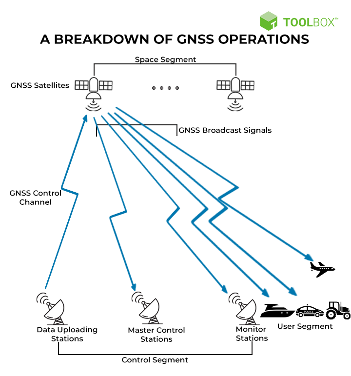
The process begins with a constellation of satellites strategically placed in medium Earth orbit. Each satellite carries highly accurate atomic clocks and broadcasts precise timing signals and its orbital data (ephemeris) to receivers on the ground. A GNSS receiver on Earth picks up these signals.
To determine its position, a receiver needs to calculate its distance from multiple satellites simultaneously. The distance to a satellite is calculated by measuring the time it takes for a signal to travel from the satellite to the receiver. Since the speed of light is constant, multiplying this time difference by the speed of light gives the pseudo-range (an approximation of the true range, accounting for clock errors).
With signals from at least four satellites, a receiver can resolve four unknowns: its latitude, longitude, altitude, and the precise time. The fourth satellite is necessary to correct for the receiver’s own clock inaccuracies, which are much less precise than the atomic clocks on board the satellites.
The Role of Timing and Orbital Data
Precise Timing is Paramount: The accuracy of a GNSS fix is directly proportional to the accuracy of the timing signals. Even a nanosecond error in timing can translate to significant positional errors. This is why satellites are equipped with sophisticated atomic clocks, and ground control segments constantly monitor and update their performance.
Ephemeris Data: Each satellite broadcasts its ephemeris, which is detailed information about its exact orbital path and position in space at any given time. This data is crucial for the receiver to accurately calculate its distance from the satellite. Ground stations meticulously track the satellites and upload updated ephemeris data regularly to ensure ongoing accuracy.
Beyond GPS: The Constituent Systems of GNSS
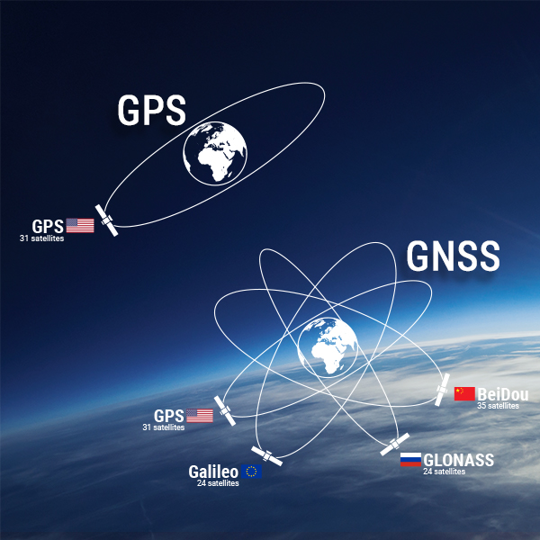
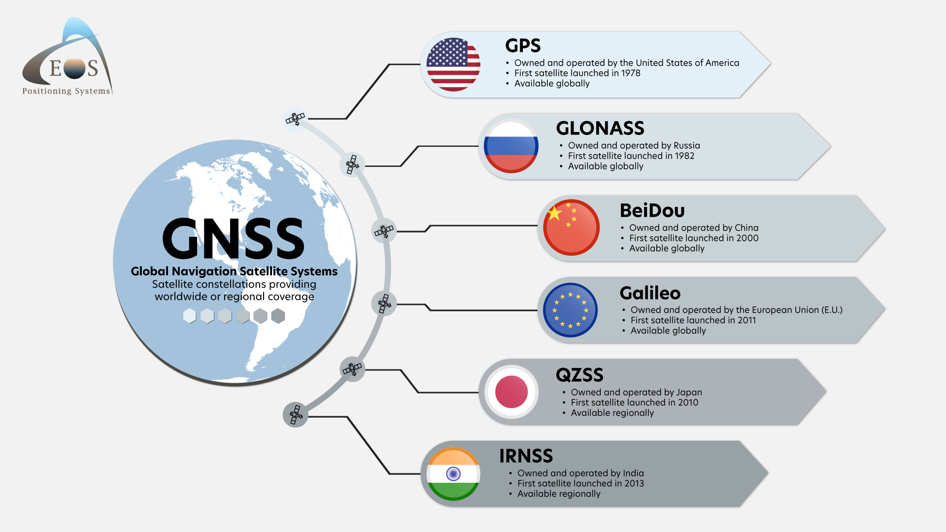
The term GNSS is often used interchangeably with GPS, but this is a common misconception. GPS (Global Positioning System) is a specific GNSS developed and operated by the United States. However, other countries and regions have developed their own independent satellite navigation systems, all falling under the broader GNSS umbrella. Understanding these different systems reveals the complexity and redundancy built into global positioning.
The United States’ Global Positioning System (GPS)
Developed by the U.S. Department of Defense, GPS was the first operational GNSS and remains the most widely recognized. It consists of a constellation of approximately 30 satellites orbiting the Earth. GPS provides standard positioning service (SPS), which is freely available for civilian use, and a precise positioning service (PPS) for authorized military users. The widespread adoption of GPS has made it a de facto standard for navigation and location-based services worldwide.
Russia’s GLONASS (Global Navigation Satellite System)
GLONASS is the Russian counterpart to GPS, developed by the Russian Aerospace Defense Forces. It also consists of a constellation of satellites in medium Earth orbit. GLONASS was initially designed for military purposes but is now accessible for civilian use. While it shares similar functionalities with GPS, GLONASS uses a different orbital plane and frequency division multiple access (FDMA) for some of its signals, meaning each satellite transmits on a slightly different frequency. This can offer complementary positioning data when used in conjunction with GPS.
Europe’s Galileo
Galileo is a global navigation satellite system created by the European Union through the European Space Agency (ESA) and the European Global Navigation Satellite Systems Agency (GSA). Galileo is designed to be a high-accuracy, high-integrity, and reliable positioning system for civilian use. It offers several service levels, including an open service that is free for basic use, a commercial service with enhanced performance, a public regulated service for government-authorized users, and a search and rescue service. Galileo’s design emphasizes interoperability with GPS and GLONASS, aiming to provide users with more accurate and robust positioning.
China’s BeiDou Navigation Satellite System (BDS)
BeiDou is China’s indigenous satellite navigation system, which has evolved from a regional system (BeiDou-1 and BeiDou-2) to a global system (BeiDou-3). BDS offers services comparable to other GNSS constellations, including positioning, navigation, and timing. It is designed to be compatible and interoperable with other GNSS, providing enhanced global coverage and accuracy. BeiDou’s development represents a significant advancement in China’s independent technological capabilities.
Other Regional Systems
While the four major systems (GPS, GLONASS, Galileo, and BeiDou) provide global coverage, several regional systems also contribute to the broader GNSS landscape:
- India’s NavIC (Navigation with Indian Constellation): Formerly known as IRNSS, NavIC is a regional navigation satellite system that provides accurate position information within the borders of India and a region extending about 1,500 km from its borders. It is designed for terrestrial, aerial, and marine applications.
- Japan’s QZSS (Quasi-Zenith Satellite System): QZSS is a four-satellite regional system that orbits Japan. It is designed to enhance GPS accuracy, particularly in urban canyons and mountainous areas where satellite signals can be obstructed. QZSS acts as a complementary system to GPS, improving its availability and integrity.
The existence of multiple GNSS constellations offers significant advantages. By using signals from satellites belonging to different systems simultaneously, receivers can achieve better accuracy, faster convergence times, and improved reliability, especially in challenging environments.
The Technological Impact of GNSS
The advent and evolution of GNSS have revolutionized countless technological sectors. Its ability to provide precise, real-time location data has become a cornerstone of modern innovation, enabling applications that were once the realm of science fiction.
Precision Agriculture and Surveying
In precision agriculture, GNSS allows farmers to precisely guide tractors for planting, fertilizing, and harvesting, optimizing resource allocation and minimizing waste. Automated steering systems, variable rate application of inputs, and precise field mapping all rely heavily on GNSS. Similarly, in surveying and mapping, GNSS receivers, particularly those with differential GNSS (DGNSS) or real-time kinematic (RTK) capabilities, enable highly accurate topographic surveys, boundary determination, and construction site layout. This has significantly reduced the time and labor required for traditional surveying methods.
Transportation and Automotive
The transportation sector has been profoundly transformed by GNSS. From the familiar in-car navigation systems that guide drivers to their destinations to the sophisticated systems used in aviation and maritime navigation, GNSS ensures safe and efficient movement. In the automotive industry, GNSS is a critical component for autonomous driving systems, providing the essential positional awareness for vehicles to navigate roads, avoid obstacles, and adhere to traffic rules. It also supports intelligent transport systems (ITS) for traffic management and vehicle tracking.
Telecommunications and Synchronization
Beyond positioning, GNSS’s precise timing capabilities are vital for telecommunications networks. Mobile phone base stations and other communication infrastructure rely on GNSS signals for precise time synchronization, which is essential for managing the handover of calls and data packets, preventing interference, and ensuring the overall stability of the network. This precise timing also underpins the operation of financial trading systems, power grids, and scientific research instruments that require highly accurate timekeeping.
Emerging Technologies and Future Trends
The influence of GNSS continues to grow with emerging technologies. Internet of Things (IoT) devices often incorporate GNSS modules for tracking assets, monitoring environmental conditions, and enabling location-aware services. Drones utilize GNSS for autonomous flight paths and navigation. Even in augmented reality (AR), GNSS plays a role in accurately overlaying digital information onto the real world based on the user’s location.
The ongoing development of new GNSS signals, augmentation systems (like SBAS and GBAS), and multi-constellation receivers promises even greater accuracy, integrity, and robustness in the future. As GNSS technology matures and becomes more integrated into our daily lives, its role as a fundamental enabler of technological advancement will only deepen. Understanding what GNSS stands for is the first step in appreciating the sophisticated global infrastructure that underpins so much of our connected world.
aViewFromTheCave is a participant in the Amazon Services LLC Associates Program, an affiliate advertising program designed to provide a means for sites to earn advertising fees by advertising and linking to Amazon.com. Amazon, the Amazon logo, AmazonSupply, and the AmazonSupply logo are trademarks of Amazon.com, Inc. or its affiliates. As an Amazon Associate we earn affiliate commissions from qualifying purchases.