
The sky, an ever-shifting canvas, frequently presents us with spectacles that are both awe-inspiring and foreboding. Among these natural marvels, the shelf cloud stands out as a particularly dramatic and visually striking phenomenon. Often mistaken for a wall cloud or even a tornado, a shelf cloud, scientifically known as an arcus cloud, signals the arrival of significant weather, typically a thunderstorm or a squall line. Its appearance is so distinctive that once you know what to look for, it becomes an unmistakable herald of change in the atmospheric landscape.
Yet, understanding such a phenomenon isn’t merely about appreciating nature’s grandeur. In our increasingly interconnected world, the visual identification of weather events like shelf clouds has profound implications across technology, branding, and even financial strategy. From the AI-powered tools that predict their formation to the brand messaging of emergency services, and the financial decisions influenced by the storms they precede, the shelf cloud serves as a vivid reminder of how deeply natural phenomena are intertwined with our modern existence. This article will delve into the precise visual characteristics of a shelf cloud, exploring its anatomy, and then bridging the gap to discuss its broader relevance in the realms of technology, branding, and finance.

The Anatomy of a Shelf Cloud: A Visual Deconstruction
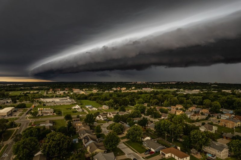
A shelf cloud is an impressive meteorological formation, distinguished by its unique structure and placement relative to the storm it accompanies. Its visual impact is undeniable, often evoking a sense of wonder mixed with apprehension due to its sheer scale and the power it represents. To truly answer “what does a shelf cloud look like?”, one must consider its various dimensions, from its overall shape to its intricate textures and dynamic movements.
Distinguishing Features and Formation
At its core, a shelf cloud is characterized by its long, low-hanging, wedge-shaped, or shelf-like appearance. This is the defining feature that gives it its common name. Imagine a massive, dark plank or shelf extending across the horizon, often appearing to ‘lean’ forward from the main storm system. Unlike a wall cloud, which typically forms within the storm and signals potential tornadic activity, a shelf cloud forms at the leading edge of a thunderstorm or line of storms. It’s essentially the visible manifestation of the cold, dense air rushing out from the storm’s downdraft, forcing warm, moist air upwards. As this warm, moist air rises and condenses, it creates the visible cloud structure.
Key visual identifiers include:
- A flat, smooth base: The underside of a shelf cloud is remarkably flat and often very well-defined, resembling the bottom of a solid object. This contrasts sharply with the often chaotic appearance of the main storm behind it.
- Ragged or turbulent underside: While the leading edge can be smooth, the underside of the shelf cloud, especially closer to the ground, can appear ragged, torn, or turbulent. This is due to the mixing of cold and warm air, creating eddies and smaller cloud features that sometimes resemble scud clouds, but are directly attached to the main shelf.
- Detached appearance: A critical visual cue is that the shelf cloud often appears somewhat detached or separate from the main precipitation area of the storm. You’ll see the shelf cloud first, moving towards you, with the rain and lightning following behind it.
- Horizontal orientation: It stretches horizontally across the sky, often spanning several miles, rather than vertically like a typical cumulonimbus tower or a rotating supercell feature. Its length can be truly epic, dominating the entire horizon.
Colors, Textures, and Dynamics
The visual appeal of a shelf cloud is further enhanced by its variations in color, texture, and the palpable sense of motion it conveys.
- Color Palette: The dominant color of a shelf cloud is usually a dark, menacing grey or blue-grey. This is due to the sheer density and depth of the cloud mass, which blocks out sunlight. However, depending on the time of day and the atmospheric conditions, other hues can be observed. If seen near sunrise or sunset, the shelf cloud can take on a more dramatic, almost ominous reddish or orange tint from the low-angle sunlight. If it’s picking up dust or dirt from the ground as it advances, it might even have a brownish or yellowish cast. The contrast between the dark shelf cloud and the lighter, often brighter sky above it is a common and striking feature.
- Textures: While its base is typically smooth, the cloud itself can display a variety of textures. Some shelf clouds exhibit a very smooth, laminar flow appearance, almost like a solid, sculpted mass. Others can be incredibly turbulent and chaotic, with swirling tendrils, wavy patterns, or even “knuckles” forming along their leading edge. These turbulent features are often indicative of stronger winds and more intense atmospheric mixing.
- Dynamic Movement: A shelf cloud is rarely static. It usually advances with a powerful, deliberate motion, often appearing to roll or churn as it moves. The leading edge seems to push forward, while the trailing edge might be obscured by the main storm’s precipitation. The speed at which it moves can be surprisingly fast, giving observers little time to react. The wind associated with the cold outflow, known as the gust front, often precedes the cloud, announcing its arrival with a sudden drop in temperature and an increase in wind speed, sometimes reaching severe levels. This dynamic nature contributes significantly to its imposing presence.
In summary, a shelf cloud looks like a colossal, low-slung, dark wedge or plank extending across the horizon, often with a smooth, defined base and a ragged, turbulent underside. It moves purposefully, typically preceding a storm, and its dark, dense appearance is a clear indicator of significant weather approaching.
Beyond the Visuals: The Science and Technology Behind Shelf Cloud Observation and Prediction
While the visual identification of a shelf cloud is crucial for immediate awareness, our understanding and ability to react to such phenomena have been profoundly enhanced by advancements in science and technology. Modern tools allow us to not only observe these formations with unprecedented detail but also to predict their arrival and assess their potential impact, transforming mere observation into actionable intelligence.
Leveraging AI and Data Analytics for Early Detection
The prediction of severe weather, including the conditions conducive to shelf cloud formation, is a complex endeavor that benefits immensely from cutting-edge technology. Artificial Intelligence (AI) and machine learning (ML) models are now at the forefront of this effort. These systems process vast quantities of meteorological data collected from a myriad of sources:
- Doppler Radar: Provides real-time information on precipitation, wind speed, and direction, identifying areas of updraft and downdraft critical for shelf cloud formation.
- Satellite Imagery: Offers broad-scale views of cloud patterns, atmospheric moisture, and temperature gradients across vast regions.
- Ground-Based Sensors and Weather Stations: Deliver localized data on temperature, humidity, pressure, and wind at the surface, which are crucial for detecting the gust front preceding a shelf cloud.
- Numerical Weather Prediction (NWP) Models: Complex simulations that use atmospheric physics to forecast future weather conditions, continually refined by AI algorithms.

AI algorithms can identify subtle patterns and correlations in this data that human forecasters might miss, improving the accuracy and lead time of severe weather warnings. For instance, an AI tool might analyze specific radar signatures, atmospheric instability indices, and surface conditions to predict the likelihood of a strong gust front forming and subsequently, a shelf cloud. These systems can also rapidly update forecasts, providing dynamic, real-time insights as conditions evolve, allowing meteorologists to issue more precise alerts for events like shelf cloud-associated severe winds. Data visualization tools then transform this complex data into intuitive, actionable displays, helping forecasters and emergency managers interpret the AI’s output efficiently.
Gadgets and Software for Weather Enthusiasts and Professionals
The integration of technology extends beyond supercomputing centers to everyday users and specialized professionals. The proliferation of weather applications and dedicated software has democratized access to meteorological data.
- Mobile Weather Apps: Many modern weather apps now incorporate high-resolution radar, satellite loops, and even predictive models that can visually represent the leading edge of storms and potential shelf cloud formation. Features like real-time wind gusts, temperature drops, and severe weather alerts become crucial for anyone under an approaching shelf cloud.
- Personal Weather Stations (PWS): For enthusiasts and community scientists, PWS devices allow individuals to collect highly localized data on temperature, humidity, wind speed, and barometric pressure. This data, when aggregated and shared (often through platforms like Weather Underground), contributes to a denser network of observations that can help confirm the arrival of gust fronts and the conditions under a shelf cloud.
- Specialized Software for Meteorologists: Professional meteorologists utilize advanced software suites for analyzing raw radar data, interpreting atmospheric soundings, and running localized weather models. These tools provide the granular detail necessary to understand the microclimates and dynamics that lead to specific cloud formations.
- Drones and Remote Sensing: For research and documentation, drones equipped with high-resolution cameras and atmospheric sensors are becoming increasingly valuable. They can safely approach and photograph shelf clouds from unique perspectives, capturing their structure and movement in detail, which aids in post-event analysis and public education. These tools, whether simple apps or complex AI systems, fundamentally change how we perceive and interact with phenomena like shelf clouds, moving us from passive observation to active engagement and preparedness.
The Brand of the Sky: Communicating Weather Phenomena and Community Preparedness
In the face of dramatic weather events like a shelf cloud, effective communication becomes paramount. The way meteorological organizations, emergency services, and even individuals convey information about these phenomena significantly impacts public understanding, trust, and ultimately, safety. This process, often subconscious, is deeply rooted in principles of branding and reputation management.
Branding Severe Weather Communication
Meteorological services and emergency management agencies essentially “brand” their severe weather warnings. This isn’t about catchy slogans, but about establishing a consistent, reliable, and easily recognizable voice and visual identity that instills confidence and prompts action.
- Consistent Visual Language: When a shelf cloud is approaching, the visual cues used in warnings (e.g., radar maps with color-coded alerts, standardized graphics for wind gusts, a clear visual depiction of the cloud itself) are critical. These visuals need to be instantly understandable, regardless of the platform (TV, mobile app, roadside digital display). A clear, consistent “look” for storm warnings builds familiarity and ensures critical information is absorbed quickly.
- Reputation for Accuracy and Timeliness: The “brand” of a weather service hinges on its reputation for accurate and timely forecasts. If a service consistently provides precise warnings about the approach of a shelf cloud and its associated gust front, trust builds. Conversely, frequent false alarms or missed warnings erode public confidence, making people less likely to heed future alerts. This is about maintaining the integrity of the information source.
- Empathetic and Actionable Messaging: Beyond accuracy, the language used in warnings is vital. Messaging needs to be clear, concise, and actionable, advising the public exactly what to do when a shelf cloud signals impending severe weather (e.g., “Seek shelter immediately,” “Secure loose outdoor objects”). The tone should be authoritative but also empathetic, acknowledging potential fear without causing undue panic. This careful crafting of messages is a form of brand communication designed to protect life and property.
Personal Branding for Weather Content Creators and Storm Chasers
Beyond institutional branding, the age of social media has given rise to a new form of personal branding centered around weather phenomena. Storm chasers, meteorology enthusiasts, and citizen journalists leverage platforms like X (formerly Twitter), Instagram, and YouTube to share their experiences and insights, often showcasing spectacular visuals of shelf clouds.
- Visual Storytelling: A high-quality photograph or video of a shelf cloud, captured at a dramatic moment, can go viral, instantly establishing the creator’s authority and reach. These individuals use compelling imagery and narrative to build a personal brand around their expertise or passion for weather. The visual impact of a shelf cloud, with its imposing structure and dynamic movement, is perfect for engaging online audiences.
- Educational Influence: Many of these content creators become informal educators, explaining the science behind a shelf cloud’s formation or differentiating it from other cloud types. Their personal brand becomes synonymous with reliable, accessible weather information, often reaching audiences who might not tune into traditional weather channels.
- Community Building: Through their content, these individuals foster communities of like-minded weather enthusiasts. They engage in discussions, share tips for safety, and even coordinate observations. This community engagement further strengthens their personal brand and amplifies their message, turning a natural phenomenon into a shared experience and a platform for education and advocacy. In this way, the majestic “brand” of the sky is reflected and amplified through both institutional and personal communication strategies, ultimately serving to inform and protect.
The Economic Ripple Effect: Financial Implications of Shelf Cloud-Associated Storms
The spectacular visual of a shelf cloud is not just a meteorological curiosity; it’s a precursor to weather events that can carry significant financial ramifications. From personal finances to corporate investments and national infrastructure, the storms associated with shelf clouds have a tangible economic footprint, necessitating careful planning, risk assessment, and strategic investment.
Insurance, Risk Assessment, and Financial Planning
The severe winds, heavy rain, and sometimes hail that often follow a shelf cloud can cause extensive damage, leading to substantial financial losses.
- Insurance Industry Impact: The insurance sector is directly on the front lines. Damage to homes, vehicles, and businesses due to wind, falling trees, and flooding results in millions, sometimes billions, in claims. Insurers continually refine their risk assessment models, using meteorological data (including frequency of severe weather like shelf cloud-producing storms) to calculate premiums and manage their exposure. Understanding weather patterns helps actuaries predict future claim payouts and allocate capital more efficiently.
- Personal Financial Planning: For individuals, the financial impact can be immediate. Homeowners might face deductibles, repair costs exceeding coverage, or increased premiums. Renters might lose belongings. Financial preparedness, such as maintaining an emergency fund, reviewing insurance policies, and taking mitigation steps (e.g., securing loose outdoor items before a storm signaled by a shelf cloud), becomes a crucial aspect of personal financial planning.
- Business Continuity and Losses: Businesses, particularly those reliant on physical infrastructure or outdoor operations, face threats to their continuity. Damage to premises, inventory, or supply chains can lead to operational disruptions, lost revenue, and recovery costs. Business interruption insurance is vital, but so is pre-emptive planning based on reliable weather forecasts, allowing for timely closures, securing assets, and activating disaster recovery protocols when a shelf cloud is spotted.
Investing in Resilient Infrastructure and Green Technologies
Beyond immediate damage, the increasing frequency and intensity of severe weather events, potentially signaled by phenomena like shelf clouds, are driving long-term investment decisions.
- Infrastructure Investment: Governments and private entities are investing heavily in making infrastructure more resilient to extreme weather. This includes stronger building codes, storm-resistant materials, upgraded power grids (e.g., undergrounding lines in vulnerable areas), and improved drainage systems. While costly upfront, these investments reduce future financial losses from repairs and disruptions. The data from meteorological observations, including the patterns of severe weather accompanying shelf clouds, directly informs where and how these investments are prioritized.
- Investment in Renewable Energy: The connection extends to green technologies. For instance, wind farms must be designed to withstand severe wind gusts associated with powerful storms. Research and development in stronger turbine materials, smarter grid management, and advanced predictive maintenance are critical investment areas to ensure the resilience and efficiency of renewable energy assets in the face of challenging weather. Similarly, solar panel arrays need robust mounting systems and sometimes even automated stowing mechanisms to protect them from high winds.
- Climate Change Adaptation and Mitigation: On a broader scale, understanding the increasing prevalence or intensity of severe weather phenomena fuels investment in climate change adaptation strategies. This includes financial instruments like catastrophe bonds, investments in climate-resilient agriculture, and funding for research into climate modeling and mitigation technologies. The visual drama of a shelf cloud thus serves as a powerful, recurring reminder of the tangible economic stakes tied to our planet’s atmospheric dynamics.
In conclusion, the shelf cloud is far more than just a striking meteorological spectacle. While its ominous, low-slung, dark, and often turbulent form provides a clear visual signal of an approaching storm, its significance extends deeply into the fabric of our technologically advanced, branding-conscious, and financially intricate society. From the sophisticated AI algorithms that predict its arrival and the essential “branding” of public safety messages, to the multi-billion-dollar financial implications for individuals, businesses, and infrastructure, the shelf cloud serves as a compelling intersection of natural power and human ingenuity, demanding both respect and proactive engagement. Understanding “what a shelf cloud looks like” is therefore not just about weather literacy, but about comprehensive preparedness in a world increasingly shaped by both natural forces and our response to them.
aViewFromTheCave is a participant in the Amazon Services LLC Associates Program, an affiliate advertising program designed to provide a means for sites to earn advertising fees by advertising and linking to Amazon.com. Amazon, the Amazon logo, AmazonSupply, and the AmazonSupply logo are trademarks of Amazon.com, Inc. or its affiliates. As an Amazon Associate we earn affiliate commissions from qualifying purchases.