
In an era defined by unparalleled technological advancement, from autonomous vehicles to augmented reality, a fundamental understanding of spatial orientation remains as crucial as ever. At the heart of this understanding lie the cardinal directions: North, South, East, and West. These four principal directions, seemingly simple concepts we learn early in life, form the bedrock upon which countless modern technologies are built, enabling everything from global navigation systems to sophisticated robotics. While their definition might appear elementary, their profound integration into the digital landscape underscores their enduring relevance and the ingenious ways tech harnesses these age-old principles for new frontiers. This article delves into the essence of cardinal directions and explores their indispensable role across the vast spectrum of technology.
The Foundational Pillars of Orientation
Before we explore the technological ramifications, it’s essential to firmly grasp what cardinal directions are and why they have been indispensable throughout human history. They are not merely labels but represent a universal framework for understanding and traversing space.
Defining North, South, East, and West
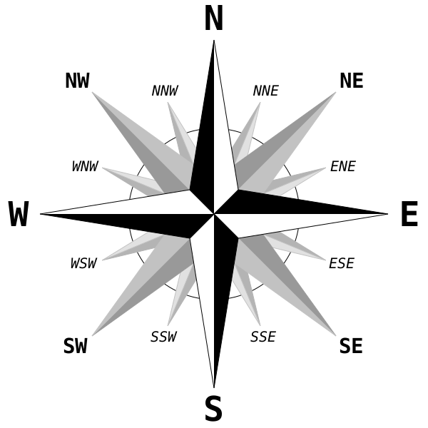
Cardinal directions refer to the four primary points of a compass: North, South, East, and West. They are typically represented by their initial letters (N, S, E, W) and are mutually perpendicular, forming the basis of a global coordinate system.
-
North: By convention, North is typically at the top of a map and often aligns with the Earth’s geographic North Pole. In practice, compasses point to the magnetic North Pole, which is slightly different from the geographic North Pole. Understanding this distinction (true North vs. magnetic North) is vital for precise navigation, particularly in aerospace and maritime applications.
-
South: Directly opposite North, South points towards the Earth’s geographic South Pole.
-
East: Located at a 90-degree angle clockwise from North, East is the direction in which the sun appears to rise.
-
West: Directly opposite East, West is where the sun appears to set, positioned 90 degrees counter-clockwise from North.
Intermediate directions, known as ordinal or intercardinal directions, further refine this system, such as Northeast (NE), Southeast (SE), Southwest (SW), and Northwest (NW). These directions provide an even finer grid for orientation and movement.
Historical Significance and Early Applications
Long before digital maps and GPS, cardinal directions were fundamental to human survival, exploration, and development. Ancient civilizations relied on celestial bodies—the sun, moon, and stars—to determine direction. The North Star (Polaris) has served as a consistent guide in the Northern Hemisphere for millennia, pointing reliably towards true North. Early mariners developed magnetic compasses, a revolutionary technology that allowed navigation without constant celestial observation, dramatically expanding trade routes and enabling global exploration.
From constructing pyramids and temples with precise astronomical alignment to mapping unknown territories, cardinal directions provided the essential framework. This historical reliance underscores their innate human utility and established the conceptual groundwork upon which modern technological navigation and spatial understanding are built. The ability to orient oneself and communicate location accurately has been a constant human need, a need that technology now addresses with unprecedented precision.
Navigating the Digital World: Cardinal Directions in Modern Tech
The foundational simplicity of cardinal directions belies their complex and critical integration into the technological marvels that guide our daily lives. From microchips in our smartphones to satellites orbiting Earth, these directions are indispensable for digital navigation and spatial awareness.
GPS and Satellite Navigation Systems
Perhaps the most prominent technological application of cardinal directions is the Global Positioning System (GPS) and its counterparts (Galileo, GLONASS, BeiDou). These satellite navigation systems work by triangulating a receiver’s position on Earth based on signals from multiple satellites. While GPS primarily provides latitude and longitude coordinates, its utility for navigation is inherently tied to cardinal directions.
When you use a navigation app, your current position is determined, and your destination is located. The app then calculates the optimal route, providing real-time directional cues like “turn North on Main Street” or “head East for two miles.” This seamless translation from raw coordinate data to human-understandable cardinal directions is crucial for intuitive user experience. Fleet management, logistics, emergency services, and even precision agriculture rely heavily on the GPS framework, which ultimately interprets and utilizes cardinal directions to guide movement across vast distances with remarkable accuracy.
The Ubiquitous Digital Compass
Modern smartphones, smartwatches, and other portable devices come equipped with built-in digital compasses. These miniature marvels typically utilize magnetometers, sensors that detect the Earth’s magnetic field. By measuring the strength and direction of this field, the device can determine its orientation relative to magnetic North. Sophisticated algorithms then compensate for magnetic declination (the difference between magnetic and true North) and integrate data from accelerometers and gyroscopes to provide a stable and accurate heading.
The digital compass is more than just a novelty; it powers a multitude of applications. It enables augmented reality (AR) experiences where digital objects are overlaid onto the real world, correctly oriented based on your viewing direction. It’s used in mapping apps to show you which way you’re facing, helping you orient yourself on a map. Furthermore, it plays a role in mobile gaming, specialized surveying tools, and even in helping visually impaired individuals navigate their surroundings by providing directional audio cues. The consistent, real-time directional data provided by these digital compasses is a testament to how fundamental cardinal directions are to modern personal tech.
Beyond the Map: Cardinal Directions in Advanced Technologies
The utility of cardinal directions extends far beyond mere navigation, permeating advanced technological domains where precision and spatial understanding are paramount.
Robotics, Drones, and Autonomous Systems
For robotics, drones, and autonomous vehicles, understanding cardinal directions is not just helpful but absolutely critical for their functionality. These systems operate within a defined environment, and their ability to perceive, plan, and execute movements relies heavily on accurate directional data.
-
Pathfinding and Navigation: Autonomous robots, whether factory floor manipulators, warehouse logistics bots, or household vacuum cleaners, use internal maps and sensor data (LIDAR, cameras, ultrasonic sensors) to determine their position and desired direction of travel. Algorithms convert abstract spatial goals into precise directional commands, ensuring the robot moves North, turns West, or navigates in a specific cardinal or intercardinal bearing.
-
Obstacle Avoidance: Knowing its own orientation relative to an obstacle (e.g., an obstacle is to the robot’s Northeast) allows the system to calculate an appropriate evasive maneuver, often involving a shift in a specific cardinal direction.
-
Drone Operations: Drones for delivery, surveillance, or aerial mapping require highly accurate GPS and inertial measurement units (IMUs) to maintain stable flight paths, execute precise maneuvers, and return to home base, all guided by pre-programmed or real-time cardinal directional commands.
-
Self-Driving Cars: These vehicles combine vast amounts of sensor data, high-definition maps, and AI to understand their surroundings. Every lane change, turn, and movement is ultimately a series of finely tuned adjustments based on cardinal and relative directions, ensuring safe and efficient transit.

Augmented Reality (AR) and Location-Based Services (LBS)
Augmented Reality (AR) systems seamlessly blend digital content with the real world, and cardinal directions are pivotal in achieving this immersive experience. For AR applications to correctly place virtual objects (e.g., a virtual arrow pointing to a café, or a fantastical creature appearing on a park bench), the system must accurately know the user’s current location, orientation, and viewing direction. This relies on fusing GPS data with digital compass readings and gyroscope data to establish a precise understanding of which cardinal direction the user is facing and how their device is tilted.
Similarly, Location-Based Services (LBS) leverage directional awareness to provide contextually relevant information. Whether it’s finding the nearest restaurant by walking North for two blocks, receiving alerts about points of interest to your East, or playing location-aware games like Pokémon Go, LBS relies on knowing not just where you are, but also which way you’re looking or moving. This enhances user experience by delivering highly personalized and spatially aware information.
Data Visualization and Geographic Information Systems (GIS)
Geographic Information Systems (GIS) are powerful tools for capturing, storing, manipulating, analyzing, managing, and presenting all types of geographical data. Cardinal directions form the fundamental grid upon which all this data is organized and visualized. Urban planners use GIS to analyze population density, infrastructure development, and environmental impact, often representing data relative to cardinal directions (e.g., “the industrial zone lies to the West of the residential area”). Environmental scientists track climate change patterns, resource distribution, and disaster impacts, using GIS to visualize how phenomena spread in specific directions. Furthermore, in fields like archaeology and geology, mapping and understanding the orientation of features relative to cardinal directions is crucial for analysis and discovery. The ability to spatially organize and interpret information using a universal directional framework makes GIS an indispensable tool across numerous disciplines.
Designing with Direction: User Experience and Interface Considerations
The integration of cardinal directions into technology is not just about raw data processing; it’s also about how this information is presented to users in an intuitive and accessible manner. Good design translates complex directional data into actionable insights.
Intuitive Interfaces for Directional Guidance
For technology to be truly useful, the underlying directional information must be communicated clearly and effectively. User interface (UI) and user experience (UX) designers leverage cardinal directions to create intuitive guidance systems. Navigation apps, for instance, don’t just show a dot on a map; they use arrows that point in the direction of travel, often aligned with cardinal directions, and provide spoken instructions that reference them (“Head North on Main Street”). Compass apps typically feature a clear dial rotating to indicate your current bearing. These visual and auditory cues are designed to mimic our natural understanding of direction, making technology an extension of our innate spatial awareness. Consistent use of North at the top of maps is another design convention that makes digital maps universally understood, allowing users to quickly orient themselves relative to cardinal points.
API Integration and Developer Tools
Behind every intuitive app lies robust software development, and the availability of sophisticated Application Programming Interfaces (APIs) and developer tools is key to integrating directional capabilities. Mapping platforms like Google Maps API, Apple MapKit, and OpenStreetMap offer developers a rich set of functionalities to incorporate location and directional services into their applications. These APIs provide methods to fetch current location, calculate routes, display maps, and even access device sensor data like compass readings. This empowers developers to build applications that understand and respond to the user’s orientation and movement in real-time. For instance, a developer can easily integrate a feature that shows the user’s current heading or provides turn-by-turn directions referencing cardinal points, accelerating the creation of diverse location-aware services and innovative experiences.
The Future Horizon: Cardinal Directions in Emerging Technologies
As technology continues to evolve at an astonishing pace, the role of cardinal directions remains central, adapting to new challenges and enabling cutting-edge innovations.
Hyper-Precision and Indoor Navigation
While GPS provides excellent outdoor navigation, its signals are often weak or unavailable indoors, creating a significant challenge for precise directional awareness. Emerging technologies are tackling this “last mile” problem. Ultra-Wideband (UWB) technology offers highly accurate indoor positioning, allowing systems to determine location and relative direction with centimeter-level precision. Wi-Fi triangulation and Bluetooth Low Energy (BLE) beacons are also used to create indoor positioning systems that can provide directional cues. Inertial Measurement Units (IMUs), incorporating accelerometers, gyroscopes, and magnetometers, are becoming increasingly sophisticated, enabling dead reckoning (estimating current position based on previous position and velocity) even without external signals. These advancements are crucial for applications like guiding emergency responders through complex buildings, enhancing smart factory automation, and creating immersive indoor AR experiences where precise directional understanding is paramount.
AI, Machine Learning, and Contextual Awareness
The synergy between cardinal directions and artificial intelligence (AI) is set to revolutionize how we interact with spatial information. AI and machine learning algorithms can process vast amounts of directional data from various sensors, learn patterns, and provide more intelligent, predictive, and contextual navigational assistance. For example, an AI-powered system might not just tell you to “head North,” but also recognize that the North-facing path is currently congested and suggest an alternative route, even if it’s longer but faster, based on real-time traffic data and your typical preferences.
Furthermore, AI can enhance autonomous systems by allowing them to interpret complex environments with greater nuanced directional awareness. This includes predicting the movement of pedestrians or other vehicles in specific cardinal directions, optimizing drone flight paths to account for wind patterns from the West, or dynamically adjusting a robot’s trajectory to navigate unforeseen obstacles more smoothly. AI makes directional guidance smarter, more adaptive, and ultimately more useful.

Ethical Considerations and Data Privacy
As our technological ability to track and utilize cardinal directional data becomes more precise and pervasive, important ethical considerations surrounding data privacy and surveillance emerge. Highly accurate location and directional tracking, while beneficial for many applications, also raise concerns about individual privacy. The “digital breadcrumbs” we leave through our devices can paint a detailed picture of our movements and habits. Developers and policymakers face the challenge of designing systems that harness the power of directional data for innovation while upholding robust privacy protections. This includes implementing anonymization techniques, securing data storage, and ensuring transparency about how directional information is collected, used, and shared. Balancing technological advancement with individual rights will be a critical task as directional technologies continue to evolve.
In conclusion, the cardinal directions—North, South, East, and West—are far more than simple geographical concepts. They are the universal language of spatial orientation, a fundamental framework that underpins the vast majority of our technological world. From the ancient mariner’s compass to the sophisticated algorithms guiding autonomous vehicles, these four points have consistently served as the bedrock for navigation, exploration, and understanding our place in the world. As we push the boundaries of AI, robotics, and immersive digital experiences, the precise and intelligent application of cardinal directions will continue to be an indispensable ingredient, driving innovation and shaping the future of how we interact with and move through our increasingly connected world.
aViewFromTheCave is a participant in the Amazon Services LLC Associates Program, an affiliate advertising program designed to provide a means for sites to earn advertising fees by advertising and linking to Amazon.com. Amazon, the Amazon logo, AmazonSupply, and the AmazonSupply logo are trademarks of Amazon.com, Inc. or its affiliates. As an Amazon Associate we earn affiliate commissions from qualifying purchases.