
In an increasingly connected world, the ability to monitor real-time events across the globe has become a powerful tool, both for professionals and curious enthusiasts alike. Among these capabilities, tracking the journey of an aircraft from takeoff to touchdown stands out as particularly fascinating. What was once the exclusive domain of air traffic controllers and dispatchers is now readily accessible to anyone with an internet connection, thanks to remarkable advancements in technology. Whether you’re eagerly awaiting a loved one’s arrival, monitoring a critical cargo shipment, or simply captivated by the intricate ballet of air traffic above, understanding “how can I track a plane” opens up a window into the complex, data-driven world of aviation.
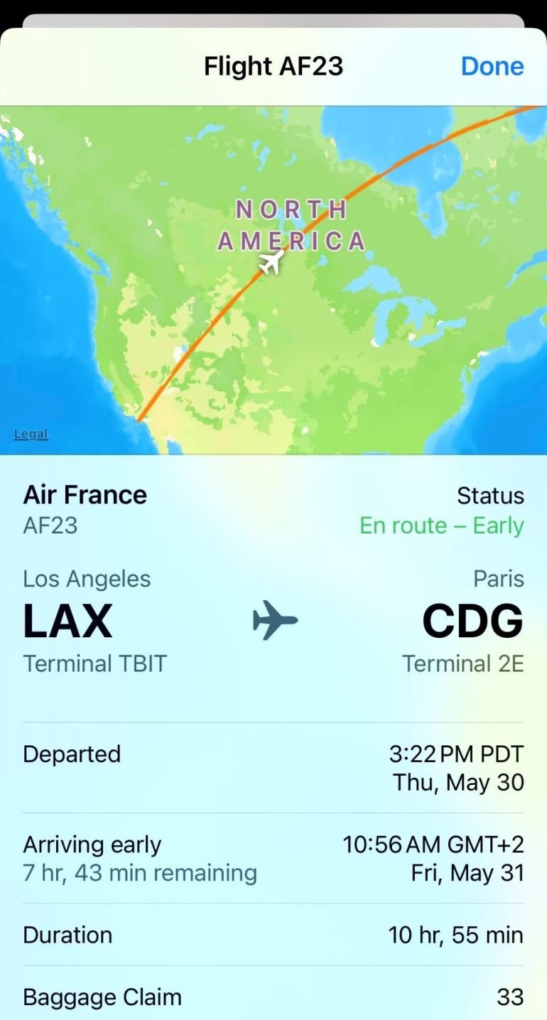
This article delves into the technological underpinnings that make real-time flight tracking possible, explores the most popular platforms and applications, guides you through the practical steps of using these tools, and even touches upon advanced methods and future trends. Prepare to embark on a journey that deciphers the digital signals and satellite streams transforming our perception of air travel.
The Core Technologies Powering Flight Tracking
At the heart of modern flight tracking lies a sophisticated interplay of radio signals, satellite communication, and ground-based networks. These technologies work in concert to collect, process, and disseminate aircraft positional data with remarkable accuracy and speed. Understanding these fundamental components is key to appreciating the robust infrastructure behind real-time flight maps.
ADS-B (Automatic Dependent Surveillance-Broadcast): The Backbone of Modern Tracking
The primary technology driving the majority of publicly available flight tracking is Automatic Dependent Surveillance-Broadcast, or ADS-B. This revolutionary system represents a significant upgrade from traditional radar by decentralizing the surveillance process. Instead of waiting for a radar beam to ping an aircraft, ADS-B-equipped aircraft broadcast their position, velocity, and other critical data at regular intervals. This information is derived from the aircraft’s onboard GPS or other navigation systems.
Ground-based ADS-B receivers, often operated by enthusiasts, private companies, and aviation organizations, pick up these signals. Once received, the data is transmitted to central servers, aggregated, and then displayed on flight tracking websites and apps. The beauty of ADS-B lies in its simplicity and effectiveness: it provides highly accurate, real-time data with relatively low infrastructure costs compared to traditional radar. Its global adoption, particularly mandated in many regions for new aircraft, has made it the undisputed backbone of modern flight tracking. However, ADS-B signals travel line-of-sight, meaning coverage is limited over vast oceans or remote land areas where ground receivers are sparse.
Radar and MLAT (Multilateration): Bridging the Gaps
While ADS-B is dominant, older technologies still play a crucial role, especially in air traffic control and in supplementing ADS-B coverage. Traditional radar systems, for instance, operate by emitting radio waves that bounce off an aircraft and return to the receiver, allowing the system to calculate the aircraft’s distance and bearing. This technology, while foundational, is primarily used by air traffic control agencies and is not typically the source for public flight tracking due to its proprietary nature and the significant infrastructure required.
However, a more accessible complementary technology is Multilateration (MLAT). MLAT is employed when an aircraft is not equipped with ADS-B, or when an ADS-B signal cannot be received by enough ground stations. Instead of relying on the aircraft to broadcast its GPS position, MLAT systems calculate an aircraft’s position by measuring the time difference of arrival (TDOA) of a signal (such as a Mode S transponder signal) at multiple geographically dispersed ground receivers. By precisely timing when the same signal reaches at least four different receivers, a computer can triangulate the aircraft’s exact location. MLAT is particularly effective for tracking aircraft in regions with dense networks of receivers but where ADS-B might not yet be fully ubiquitous. It cleverly fills in the tracking blanks, providing a more comprehensive air traffic picture.
Satellite-Based Tracking: Global Reach Achieved
The inherent limitation of ground-based ADS-B and MLAT—their reliance on line-of-sight or proximity to ground stations—means that vast expanses of the Earth, particularly oceans, polar regions, and remote landmasses, traditionally remained untracked. This changed dramatically with the advent of satellite-based ADS-B reception.
Companies like Aireon, in partnership with Iridium, have deployed ADS-B receivers on low-Earth orbit satellites (specifically, the Iridium NEXT constellation). These satellites continuously collect ADS-B signals directly from aircraft below and relay them to ground stations. This groundbreaking development extends ADS-B coverage to virtually every corner of the planet, providing truly global, real-time flight tracking. This has profound implications for aviation safety, efficiency, and environmental monitoring, allowing air traffic controllers to manage flights more precisely over previously dark areas, and ensuring that no flight goes “missing” from surveillance. Satellite-based tracking represents the pinnacle of current flight tracking technology, offering unparalleled global coverage.
Popular Platforms and Applications for Flight Tracking
With these powerful technologies at work, various platforms have emerged to aggregate and display flight data in user-friendly formats. These tools range from sophisticated web interfaces to intuitive mobile apps, catering to a wide spectrum of users from casual observers to aviation professionals.
Web-Based Flight Trackers: Accessibility at Your Fingertips
The most common entry point for anyone wanting to track a plane is through web-based platforms. These websites typically feature interactive maps, detailed flight information, and powerful search functionalities accessible from any internet-connected device.
- FlightAware: One of the pioneers in flight tracking, FlightAware offers comprehensive real-time and historical flight data. Users can track flights by airline, flight number, route, or airport. Its interface is robust, providing details like aircraft type, speed, altitude, squawk code, and estimated arrival times. FlightAware also offers predictive tools, showing potential delays and cancellations. While a free version provides extensive features, premium subscriptions unlock advanced functionalities like weather overlays, historical data access for longer periods, and fewer ads.
- FlightRadar24: Known for its slick, visually engaging interface and extensive global coverage (thanks to a vast network of ground receivers and satellite data), FlightRadar24 is a favorite among enthusiasts. Beyond basic tracking, it often displays live cockpit views (for equipped aircraft), detailed aircraft specifications, and even allows users to “rewind” and play back historical flights. Its map features are highly customizable, with options for different map types and filters for aircraft types, airlines, and airports.
- PlaneFinder: Similar to its competitors, PlaneFinder offers real-time tracking, flight details, and historical data. It’s often praised for its intuitive interface and its unique “augmented reality” feature in its mobile app (which we’ll discuss next). These platforms frequently rely on a blend of ADS-B, MLAT, and satellite data to provide the most complete picture possible, continuously updating aircraft positions every few seconds.
Mobile Applications: Tracking on the Go
For convenience and portability, dedicated mobile applications have become incredibly popular. These apps often mirror the functionality of their web-based counterparts but add features optimized for smartphones and tablets, making flight tracking accessible from anywhere.
- FlightAware (iOS/Android): The mobile app provides all the core functionalities of the website, including flight search, real-time map tracking, and flight status alerts. Its push notifications are particularly useful for receiving updates on delays, gate changes, and arrival/departure times directly to your device.
- FlightRadar24 (iOS/Android): Considered by many to have one of the best mobile interfaces, FlightRadar24’s app is rich with features. Beyond real-time tracking, it includes a powerful augmented reality (AR) mode: simply point your phone at the sky, and the app will identify planes flying overhead, displaying their flight information directly on your screen. This feature is a game-changer for spotting enthusiasts.
- PlaneFinder (iOS/Android): PlaneFinder also offers an excellent mobile experience with its own AR feature and a user-friendly design. Many of these apps allow users to filter flights, save favorite aircraft or routes, and delve into detailed aircraft information, often including photos and operational history. The convenience of having real-time flight data in your pocket has made mobile apps an indispensable tool for travelers, aviation enthusiasts, and anyone curious about the planes above.
Specialized Tools for Enthusiasts and Professionals
Beyond mainstream public platforms, specific tools cater to niche audiences with more advanced requirements or a desire for a deeper dive into the data.
For aviation hobbyists, especially those who enjoy building and tinkering, setting up a personal ADS-B receiver offers a direct connection to the raw flight data. Using affordable hardware like an SDR (Software Defined Radio) dongle and a Raspberry Pi computer, enthusiasts can create their own ground stations to receive local ADS-B signals. Software like PiAware (from FlightAware) or FlightAware’s own feeder software allows these hobbyists to contribute their collected data to the global network, often receiving a premium subscription to the tracking service in return. This not only empowers individuals to have a hyper-local, real-time view of air traffic but also strengthens the overall coverage of the public tracking services.
On the professional front, airlines, airport operations, and air traffic control centers utilize highly sophisticated, proprietary systems that integrate various data sources beyond what’s publicly available. These systems offer granular control, predictive analytics, and integration with operational databases to manage fleets, optimize routes, and ensure air safety. While these tools are not publicly accessible, they represent the apex of flight tracking technology, built upon the same fundamental data streams discussed earlier.
Practical Guides: How to Start Tracking a Plane

Getting started with flight tracking is remarkably simple, thanks to the intuitive design of modern platforms. Whether you’re tracking a specific flight or just exploring air traffic, a few basic steps will get you up and running.
Step-by-Step: Using a Web-Based Tracker
Let’s use a common platform like FlightAware as an example:
- Navigate to the Website: Open your web browser and go to www.flightaware.com (or FlightRadar24.com, PlaneFinder.net).
- Locate the Search Bar: Typically, a prominent search bar is located at the top or center of the homepage.
- Enter Flight Information: You can search using:
- Flight Number: The most direct method (e.g., “UA123”).
- Route: Enter the departure and arrival airports (e.g., “SFO to JFK”).
- Airline and Aircraft Type: Less precise but useful for general exploration (e.g., “Delta 737”).
- Airport Code: Search for all arrivals or departures at a specific airport (e.g., “LAX”).
- Initiate Search: Click the search button or press Enter.
- View Flight Details: If a specific flight is found, you’ll be taken to its dedicated page, showing its position on a map, current speed, altitude, estimated arrival time, and other relevant data.
- Explore the Map: The interactive map allows you to zoom in/out, pan, and click on other aircraft to see their details. You can often apply filters to view specific types of flights (e.g., cargo, private, commercial).
Step-by-Step: Using a Mobile App
Using a mobile app offers a similar experience, often with added convenience and features:
- Download the App: Search for “FlightAware,” “FlightRadar24,” or “PlaneFinder” in your device’s app store (Google Play Store for Android, Apple App Store for iOS) and install it.
- Open the App and Grant Permissions: The app may request location services permission to utilize features like “point at sky” AR.
- Use the Search Function: Similar to the web version, a search icon or bar will be present to input flight numbers, routes, or airport codes.
- Explore Features:
- Live Map: The default view is usually a live map of air traffic.
- AR Mode (FlightRadar24/PlaneFinder): Look for an AR button (often an icon resembling a camera). Tap it, point your phone towards the sky, and planes overhead will be identified with their flight details overlaid on your camera view.
- Notifications: Most apps allow you to “star” or “follow” a flight to receive push notifications for status updates, delays, or gate changes.
- Customize Filters: Use filter options to narrow down the displayed aircraft by airline, aircraft type, altitude, or speed.
Interpreting Flight Data: Beyond the Basics
Once you’re tracking a plane, understanding the data presented enhances the experience:
- Altitude (FL/Feet): Usually displayed in thousands of feet or as a Flight Level (FL), where FL350 means 35,000 feet.
- Speed (knots/mph): Ground speed (speed relative to the ground) is common. Indicated airspeed (IAS) is what the pilot sees, and true airspeed (TAS) is speed relative to the airmass.
- Squawk Code (Transponder Code): A four-digit octal number assigned by air traffic control. Certain codes have special meanings (e.g., 7700 for emergency, 7600 for radio failure, 7500 for hijack).
- Aircraft Type: The model of the aircraft (e.g., Boeing 737, Airbus A320).
- Registration (Tail Number): A unique identifier for the aircraft (e.g., N12345 in the US, G-ABCD in the UK).
- Origin/Destination: The departure and arrival airports.
- Estimated Time of Arrival (ETA): The projected arrival time, dynamically updated based on the flight’s progress and any delays.
- Flight History: Often accessible, showing previous flights of that specific aircraft.
By understanding these data points, you gain a richer, more insightful perspective into each flight’s journey and the broader air traffic ecosystem.
Advanced Tracking and Future Trends
The world of flight tracking is constantly evolving, with ongoing innovations promising even greater accuracy, coverage, and integration into our daily lives. From DIY projects to cutting-edge AI, the future holds exciting possibilities.
Building Your Own ADS-B Receiver: A Hobbyist’s Guide
For those with a technical bent and a desire for a deeper engagement, building a personal ADS-B receiver is an incredibly rewarding project. This setup allows you to directly receive aircraft signals in your local area and contribute to global tracking networks.
The core components typically include:
- SDR Dongle (Software Defined Radio): A low-cost USB device that can receive a wide range of radio frequencies, including the 1090 MHz band used by ADS-B.
- Antenna: A specialized antenna designed for the 1090 MHz frequency to maximize signal reception.
- Raspberry Pi: A small, affordable single-board computer that acts as the processing unit, running Linux and specialized software.
- Software: Programs like dump1090 (to decode ADS-B messages) and feeding software (e.g., FlightAware’s PiAware or FlightRadar24’s feeder) that send your decoded data to the central tracking services.
This DIY approach offers several benefits: a highly localized and real-time view of air traffic, the satisfaction of contributing to a global data network, and often, a free premium subscription to the tracking services as a thank you for your data contribution. It’s a perfect blend of technology, hobby, and community.
The Future of Flight Tracking: Enhanced Accuracy and Coverage
The trajectory of flight tracking points towards even greater precision and ubiquitous coverage. Satellite-based ADS-B, as demonstrated by Aireon, is continually expanding and improving, ensuring that virtually no corner of the planet remains untracked. This capability is not just for curiosity; it’s a critical component for future air traffic management, enabling more efficient flight paths, reducing fuel consumption, and significantly enhancing safety, especially over oceans.
Furthermore, the integration of Artificial Intelligence (AI) and machine learning (ML) is poised to revolutionize how we interpret and utilize flight data. AI can analyze vast datasets of historical flights, weather patterns, air traffic control directives, and airline schedules to provide more accurate predictive analytics. This could mean more precise estimations of delays, better forecasting of flight disruptions, and even proactive rerouting suggestions to mitigate adverse events. The ability to predict potential issues before they arise will be invaluable for airlines, airports, and passengers alike. The potential for tracking beyond traditional aircraft, such as commercial drones and urban air mobility vehicles, is also an emerging area that will leverage similar technologies.
Privacy and Data Security Considerations
While the accessibility of flight tracking data is largely beneficial, it also brings forth important discussions around privacy and data security. Most public tracking platforms implement measures to filter or restrict the display of certain types of flights, particularly those related to military operations, sensitive government movements, or private aircraft whose owners have requested their flight data not be publicly broadcast (often through programs like the FAA’s LADD program).
The data collected from ADS-B and other sources is generally limited to positional and operational information, not personal data about passengers or crew. However, the ability to track the movement of specific individuals or corporate jets can raise concerns. Operators of tracking services are generally diligent in adhering to regulations and respecting privacy requests where applicable, striving to balance transparency with legitimate security and privacy needs. As technology advances, these considerations will continue to evolve, requiring ongoing dialogue and policy adjustments to ensure responsible data utilization.

Conclusion
The journey from traditional radar to sophisticated satellite-based systems has transformed how we perceive and interact with air travel. What was once a complex, specialized field is now an accessible realm, thanks to the continuous innovation in communication, data processing, and user interface design. The question “how can I track a plane?” no longer hints at a technical challenge but points to a readily available tool offering a wealth of information.
From satisfying a simple curiosity about a passing aircraft to providing critical real-time updates for travelers and logistics professionals, flight tracking technology has become an integral part of our digital landscape. As we look to the future, the convergence of advanced sensor technology, global satellite networks, and intelligent AI will undoubtedly bring even more powerful and insightful ways to monitor the skies, making air traffic an even more transparent and interconnected spectacle for all. So, the next time you glance up at a plane soaring overhead, remember that its journey is no longer a mystery, but a dynamic data stream waiting to be explored.
aViewFromTheCave is a participant in the Amazon Services LLC Associates Program, an affiliate advertising program designed to provide a means for sites to earn advertising fees by advertising and linking to Amazon.com. Amazon, the Amazon logo, AmazonSupply, and the AmazonSupply logo are trademarks of Amazon.com, Inc. or its affiliates. As an Amazon Associate we earn affiliate commissions from qualifying purchases.